EP0915321A2 - System zur Messung der Höhe eines Fahrzeuges, verbunden mit einem GPS-Satellitennavigationssystem - Google Patents
System zur Messung der Höhe eines Fahrzeuges, verbunden mit einem GPS-Satellitennavigationssystem Download PDFInfo
- Publication number
- EP0915321A2 EP0915321A2 EP99100029A EP99100029A EP0915321A2 EP 0915321 A2 EP0915321 A2 EP 0915321A2 EP 99100029 A EP99100029 A EP 99100029A EP 99100029 A EP99100029 A EP 99100029A EP 0915321 A2 EP0915321 A2 EP 0915321A2
- Authority
- EP
- European Patent Office
- Prior art keywords
- altitude
- gps
- calculated
- vehicle
- detecting
- Prior art date
- Legal status (The legal status is an assumption and is not a legal conclusion. Google has not performed a legal analysis and makes no representation as to the accuracy of the status listed.)
- Withdrawn
Links
Images






Classifications
-
- G—PHYSICS
- G01—MEASURING; TESTING
- G01C—MEASURING DISTANCES, LEVELS OR BEARINGS; SURVEYING; NAVIGATION; GYROSCOPIC INSTRUMENTS; PHOTOGRAMMETRY OR VIDEOGRAMMETRY
- G01C21/00—Navigation; Navigational instruments not provided for in groups G01C1/00 - G01C19/00
- G01C21/26—Navigation; Navigational instruments not provided for in groups G01C1/00 - G01C19/00 specially adapted for navigation in a road network
- G01C21/28—Navigation; Navigational instruments not provided for in groups G01C1/00 - G01C19/00 specially adapted for navigation in a road network with correlation of data from several navigational instruments
-
- G—PHYSICS
- G01—MEASURING; TESTING
- G01C—MEASURING DISTANCES, LEVELS OR BEARINGS; SURVEYING; NAVIGATION; GYROSCOPIC INSTRUMENTS; PHOTOGRAMMETRY OR VIDEOGRAMMETRY
- G01C5/00—Measuring height; Measuring distances transverse to line of sight; Levelling between separated points; Surveyors' levels
- G01C5/005—Measuring height; Measuring distances transverse to line of sight; Levelling between separated points; Surveyors' levels altimeters for aircraft
-
- G—PHYSICS
- G01—MEASURING; TESTING
- G01S—RADIO DIRECTION-FINDING; RADIO NAVIGATION; DETERMINING DISTANCE OR VELOCITY BY USE OF RADIO WAVES; LOCATING OR PRESENCE-DETECTING BY USE OF THE REFLECTION OR RERADIATION OF RADIO WAVES; ANALOGOUS ARRANGEMENTS USING OTHER WAVES
- G01S19/00—Satellite radio beacon positioning systems; Determining position, velocity or attitude using signals transmitted by such systems
- G01S19/38—Determining a navigation solution using signals transmitted by a satellite radio beacon positioning system
- G01S19/39—Determining a navigation solution using signals transmitted by a satellite radio beacon positioning system the satellite radio beacon positioning system transmitting time-stamped messages, e.g. GPS [Global Positioning System], GLONASS [Global Orbiting Navigation Satellite System] or GALILEO
- G01S19/42—Determining position
- G01S19/45—Determining position by combining measurements of signals from the satellite radio beacon positioning system with a supplementary measurement
- G01S19/47—Determining position by combining measurements of signals from the satellite radio beacon positioning system with a supplementary measurement the supplementary measurement being an inertial measurement, e.g. tightly coupled inertial
Definitions
- the present invention relates to a navigation system mounted on vehicles such as automobiles, aircrafts and vessels, and more particularly to a system for detecting an altitude in the navigation system.
- a position detecting means as a Global Positioning System (GPS).
- GPS Global Positioning System
- a receiver mounted on the vehicle receives radio waves transmitted from a plurality of GPS satellites to calculate the present position.
- a mark representing the position is indicated on a map shown on a display.
- the GPS generally uses three or more GPS satellites to determine a two-dimensional position of the vehicle. That is the latitude and longitude are calculated based on position data of each satellite and a pseudo-distance between the vehicle and each satellite including a time offset caused by a time lag of the receiver.
- radio waves are transmitted from more than four satellites, thereby enabling to detect the three-dimensional position of the vehicle. Namely, the altitude of the vehicle is further calculated in addition to the latitude and the longitude.
- the conventional GPS accordingly calculates the altitude only when radio waves from more than four satellites are received.
- the two-dimensional position is calculated, setting the known altitude calculated at the last three-dimensional positioning as the current altitude.
- the known altitude may deviate from the actual altitude, especially when the vehicle is driven in a mountainous region where the altitude largely fluctuates.
- the difference between the actual altitude and the set altitude increases with a lapse of time, thereby causing error in the calculated position of the vehicle.
- an external memory such as a CD-ROM storing a corresponding altitude obtained from a map or obtained by a manometer for detecting altitude dependent on ambient pressure of the vehicle, is provided on the vehicle for the GPS to determine the actual altitude.
- an altitude derived from the memory is used to calculate the position of the vehicle. The difference between the altitude calculated at the last four-satellite detection and the actual altitude may be so great that a mark indicating the position of the vehicle on the display abruptly jumps to another position.
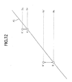
- Fig. 12 shows an example of altitude variation.
- the line AL shows an actual variation of altitude
- a point A is a last detection position of the four-satellite detection
- a point B is a resumed detection position by the four-satellite detection. Therefore, the detection between points A and B is performed by the three-satellite detection.
- the altitude Hp at the point A is obtained by the memory
- the altitude HG at a point A' is obtained by the four-satellite detection.
- the altitude Hc at the point B is obtained by a memory
- the altitude Hc' at a point B' is obtained by the four-satellite detection. There is a large deviation from the actual altitude Hc.
- An object of the present invention is to provide a positioning system where the mark on the display smoothly moves.
- a system for detecting an altitude of a vehicle dependent on a global positioning system comprising, determining means for determining that the altitude can not be calculated from data applied from satellites and for producing a provisional calculation demand, calculating means responsive to the provisional calculation demand for calculating a provisional altitude by correcting a GPS altitude obtained by the GPS at a last time and a reference altitude obtained by outside means with a smoothing coefficient.
- GPS global positioning system
- a GPS receiver 10 mounted on a vehicle has a GPS receiving section 20 to which radio waves from four satellites are applied through a GPS antenna 11, preamplifier 12 and a bandpass filter 13.
- the GPS receiver 10 has a crystal oscillator 14 for generating a reference frequency which is a timing control signal for the entire receiver 10.
- a clock 15 is further provided for generating clock pulses in accordance with the reference frequency fed from the crystal oscillator 14.
- the GPS receiving section 20 has a frequency synthesizer 21 which is applied with the reference frequency from the crystal oscillator 14 to generate a signal having the same pattern as a carrier wave from the GPS satellites and a data signal representing data such as the positions of the GPS satellites and the states of the clocks therein.
- a code generator 22 is provided in the GPS receiving section 20 for generating a code signal in accordance with the clock pulses.
- the code signal has the same pattern as a distance signal applied from the GPS satellites.
- the radio waves applied to the GPS receiving section 20 is multiplied by the synthesized signal from the frequency synthesizer 21 and by the code signal from the code generator 22 and fed to a data signal detector 23 and to a distance signal detector 24.
- the data signal detector 23 extracts the data signal representing the positions of the GPS satellites from the received signal.
- the distance signal detector 24 extracts the distance signal representing the distance between each GPS satellite and the vehicle in accordance with the code signal.
- the data signal and the distance signal are applied to a signal processor 16.
- the signal processor 16 is applied with the clock pulses generated by the clock pulse generator 15 so as to process the fed signals at the timing which coincides with the clock pulses.
- the processed signals are applied to a calculator 17 to produce GPS data D G , that is data concerning the position of the vehicle.
- the calculator 17 is provided with means for correcting the calculated altitude, the operation of which is described in detail hereinafter.
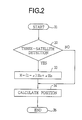
- the program for determining the position of the vehicle starts at a step 31.
- the signal processor 16 determines at a step 32 that a three-satellite detection instead of a four-satellite detection is to be carried out.
- H G is an altitude which was obtained at the last four-satellite detection
- H O is a reference altitude obtained by such devices as a manometer
- ⁇ (0 ⁇ ⁇ ⁇ 1) is a predetermined smoothing coefficient.
- the position is calculated in accordance with the calculated altitude H and the program ends at a step 35.
- the altitude smoothly changes.
- the program goes directly from the step 32 to the step 34.
- the program is repeated at a regular interval.
- the operation in accordance with the second embodiment starts at a step 41 and at a step 42, it is determined whether the three-satellite detection is carried out.
- the answer is YES
- the signal processor 16 determines that it is the first routine since the change
- the program proceeds to a step 45 wherein the altitude H is calculated in accordance with the equation (1) described in the first embodiment. Accordingly, the position of the vehicle is calculated at a step 49 and the routine ends at a step 50.
- the period ⁇ T is compared with a period T2 which is an empirically predetermined value appropriate for correcting the altitude H .
- the program goes to the step 45 where the altitude is calculated in accordance with the equation (1) and the position is further calculated at a step 49.
- the altitude H is set at the actual altitude H O .
- the program jumps from the step 42 to the step 49 without correcting the altitude and ends at a step 50.
- the altitude H is corrected only for a predetermined period of time.
- the third embodiment of the present invention is also adapted to prevent the altitude H from excessively deviating from the actual altitude H O .
- the smoothing coefficient is set between 0 and 1 (0 ⁇ ⁇ ⁇ 1) and should not exceed 1 despite the calculation of the above equation.
- the altitude H is hence calculated in accordance with the equation (1) at a step 57. Thereafter, the position is calculated at a step 58 and the program ends at a step 59.
- the smoothing coefficient increases with the lapse of time.
- the calculated altitude gradually approximates the actual altitude H O until, when the smoothing coefficient reaches 1, the altitude equals H O .
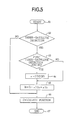
- a vertical dilution of precision (VDOP) is detected in order to obtain the smoothing coefficient ⁇ . More particularly, when the precision of the calculated altitude H is high so that the value of the VDOP is small, the smoothing coefficient ⁇ is set at a small value.
- steps 61 to 63 are identical to the steps 51 to 53 in Fig. 4.
- the coefficient ⁇ is set in accordance with the VDOP as follows.
- a small smoothing coefficient ⁇ is set so that the calculated altitude H is close to the altitude H G .
- the smoothing coefficient also increases, thereby rendering the altitude H to approximate the actual altitude H O .
- the program goes from the step 63 to the step 65 without obtaining the smoothing coefficient ⁇ .
- the coefficient ⁇ is thus constant throughout the three-satellite detection.
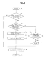
- the steps 71 to 73 are identical to steps 61 to 63 of Fig. 5.
- the program proceeds to a step 74 where code numbers of the satellites are stored in a memory.
- the altitude H is calculated in the same manner as in the first and second embodiments, and the position of the vehicle is accordingly calculated at a step 78.
- the routine thus ends at a step 79.
- the program goes from the step 73 to a step 76 where the code numbers of three-satellites transmitting waves to the GPS receiver 10 are compared with the code numbers stored in the memory at the step 74. If the numbers are the same, the program proceeds to the step 75 to calculate the altitude H .
- the code numbers differ, it means that the combination of the functioning satellite has changed. In such a case, there may be an error in the altitude H G so that it is undesirable to use the altitude H G in calculating the altitude H and hence the position of the vehicle. Accordingly, the actual altitude H O itself is determined as the altitude H without any correction.
- the position of the vehicle is calculated at the step 78 in accordance with the actual altitude H O .
- a point C is a present position the altitude H Gn of which is to be calculated
- a point B shows a last position the reference altitude H P (n-1) of which has been obtained from a memory at the last time
- a point A shows a point before last the reference altitude H P (n-2) has been obtained from the memory at the time before last.
- B' is a point representing a GPS altitude H G (n-1) detected by the last four-satellite detection
- A' is a point representing a GPS altitude H G (n-2) at the time before last.
- the altitude difference between GPS altitudes H G (n-1) and H G (n-2) is equal to the difference ⁇ H C .
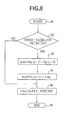
- H Gn H G (n-1) + ⁇ H O .
- ⁇ H O is calculated at a step 83.
- the height H Gn is calculated at a step 84, and the position is calculated at a step 85.
- the embodiment is to obtain the height at the point B of Fig. 7.
- the position of the point A is calculated.
- the height H G (n-1) at the point B is calculated as a step 95.
- Fig. 10 is the combination of the sixth embodiment of Fig. 8 and the fifth embodiment of Fig. 6.
- Fig. 11 is the combination of the embodiment of Fig. 9 and the embodiment of Fig. 6.
Landscapes
- Engineering & Computer Science (AREA)
- Radar, Positioning & Navigation (AREA)
- Remote Sensing (AREA)
- Physics & Mathematics (AREA)
- General Physics & Mathematics (AREA)
- Computer Networks & Wireless Communication (AREA)
- Automation & Control Theory (AREA)
- Position Fixing By Use Of Radio Waves (AREA)
- Navigation (AREA)
Applications Claiming Priority (5)
| Application Number | Priority Date | Filing Date | Title |
|---|---|---|---|
| JP407193A JPH06213997A (ja) | 1993-01-13 | 1993-01-13 | Gps受信機 |
| JP407093A JPH06213996A (ja) | 1993-01-13 | 1993-01-13 | Gps受信機 |
| JP4070/93 | 1993-01-13 | ||
| JP4071/93 | 1993-01-19 | ||
| EP94100314A EP0606890A1 (de) | 1993-01-13 | 1994-01-11 | System zur Messung der Höhe eines Fahrzeuges, verbunden mit einem GPS-Satellitennavigationssystem |
Related Parent Applications (1)
| Application Number | Title | Priority Date | Filing Date |
|---|---|---|---|
| EP94100314A Division EP0606890A1 (de) | 1993-01-13 | 1994-01-11 | System zur Messung der Höhe eines Fahrzeuges, verbunden mit einem GPS-Satellitennavigationssystem |
Publications (2)
| Publication Number | Publication Date |
|---|---|
| EP0915321A2 true EP0915321A2 (de) | 1999-05-12 |
| EP0915321A3 EP0915321A3 (de) | 1999-06-02 |
Family
ID=26337790
Family Applications (2)
| Application Number | Title | Priority Date | Filing Date |
|---|---|---|---|
| EP99100029A Withdrawn EP0915321A3 (de) | 1993-01-13 | 1994-01-11 | System zur Messung der Höhe eines Fahrzeuges, verbunden mit einem GPS-Satellitennavigationssystem |
| EP94100314A Withdrawn EP0606890A1 (de) | 1993-01-13 | 1994-01-11 | System zur Messung der Höhe eines Fahrzeuges, verbunden mit einem GPS-Satellitennavigationssystem |
Family Applications After (1)
| Application Number | Title | Priority Date | Filing Date |
|---|---|---|---|
| EP94100314A Withdrawn EP0606890A1 (de) | 1993-01-13 | 1994-01-11 | System zur Messung der Höhe eines Fahrzeuges, verbunden mit einem GPS-Satellitennavigationssystem |
Country Status (2)
| Country | Link |
|---|---|
| US (1) | US5434574A (de) |
| EP (2) | EP0915321A3 (de) |
Cited By (1)
| Publication number | Priority date | Publication date | Assignee | Title |
|---|---|---|---|---|
| EP1892540A1 (de) * | 2006-08-25 | 2008-02-27 | Seiko Epson Corporation | Positioniervorrichtung, Verfahren zur Steuerung der Positioniervorrichtung und Aufzeichnungsmedium |
Families Citing this family (17)
| Publication number | Priority date | Publication date | Assignee | Title |
|---|---|---|---|---|
| US8352400B2 (en) | 1991-12-23 | 2013-01-08 | Hoffberg Steven M | Adaptive pattern recognition based controller apparatus and method and human-factored interface therefore |
| US10361802B1 (en) | 1999-02-01 | 2019-07-23 | Blanding Hovenweep, Llc | Adaptive pattern recognition based control system and method |
| US5781146A (en) * | 1996-03-11 | 1998-07-14 | Imaging Accessories, Inc. | Automatic horizontal and vertical scanning radar with terrain display |
| US5828332A (en) * | 1996-03-11 | 1998-10-27 | Imaging Accessories, Inc. | Automatic horizontal and vertical scanning radar with terrain display |
| US5761095A (en) * | 1997-03-10 | 1998-06-02 | Rgs, Llc | System for monitoring the depth of snow |
| DE19717829A1 (de) * | 1997-04-26 | 1998-11-05 | Bosch Gmbh Robert | Verfahren zur Positionsbestimmung zum Zwecke der Navigation eines Kraftfahrzeugs im Straßenverkehr |
| US6151549A (en) * | 1997-09-03 | 2000-11-21 | Cummins Engine Co Inc | System for controlling engine fueling according to vehicle location |
| US7268700B1 (en) | 1998-01-27 | 2007-09-11 | Hoffberg Steven M | Mobile communication device |
| US7966078B2 (en) | 1999-02-01 | 2011-06-21 | Steven Hoffberg | Network media appliance system and method |
| RU2173862C2 (ru) * | 1999-04-28 | 2001-09-20 | Государственное предприятие - "КБ Оризон-Навигация" | Способ и устройство обработки радиосигналов навигационных спутников gps и глонасс |
| US6756938B2 (en) * | 2001-11-06 | 2004-06-29 | Motorola, Inc. | Satellite positioning system receivers and methods therefor |
| US9818136B1 (en) | 2003-02-05 | 2017-11-14 | Steven M. Hoffberg | System and method for determining contingent relevance |
| US7299113B2 (en) | 2004-01-15 | 2007-11-20 | The Boeing Company | System and method for determining aircraft tapeline altitude |
| RU2416102C2 (ru) * | 2007-12-26 | 2011-04-10 | Закрытое акционерное общество "Конструкторское бюро навигационных систем" (ЗАО "КБ НАВИС") | Приемник аппаратуры потребителей сигналов глобальных спутниковых навигационных систем |
| US20090267832A1 (en) * | 2008-04-29 | 2009-10-29 | Texas Instruments Incorporated | Systems and methods for dynamically determining position |
| RU2435307C1 (ru) * | 2010-05-25 | 2011-11-27 | Государственное образовательное учреждение высшего профессионального образования Московский авиационный институт (государственный технический университет) (МАИ) | Устройство для обработки навигационных сигналов глонасс, gps и галилео |
| US20130197800A1 (en) * | 2012-01-31 | 2013-08-01 | Autotalks Ltd. | Method and system for gps augmentation using cooperative altitude learning |
Family Cites Families (14)
| Publication number | Priority date | Publication date | Assignee | Title |
|---|---|---|---|---|
| JPS61137086A (ja) * | 1984-12-07 | 1986-06-24 | Nissan Motor Co Ltd | 車両用位置計測装置 |
| JPS61173303A (ja) * | 1985-01-28 | 1986-08-05 | Hitachi Ltd | 位置決め装置 |
| JPS62882A (ja) * | 1985-06-27 | 1987-01-06 | Toshiba Corp | 航法装置 |
| JPS63151880A (ja) * | 1986-12-16 | 1988-06-24 | Furuno Electric Co Ltd | Gps測位装置 |
| JPH02181681A (ja) * | 1989-01-07 | 1990-07-16 | Fujitsu Ltd | 推測航法併用の全世界測位システム |
| US5072227A (en) * | 1989-09-26 | 1991-12-10 | Magnavox Government And Industrial Electronics Company | Method and apparatus for precision attitude determination |
| JPH0470584A (ja) * | 1990-07-11 | 1992-03-05 | Mitsubishi Electric Corp | 衛星航法装置 |
| US5185610A (en) * | 1990-08-20 | 1993-02-09 | Texas Instruments Incorporated | GPS system and method for deriving pointing or attitude from a single GPS receiver |
| US5030957A (en) * | 1991-02-26 | 1991-07-09 | The United States Of America As Represented By The Secretary Of The Navy | Method of simultaneously measuring orthometric and geometric heights |
| JPH04369492A (ja) * | 1991-06-18 | 1992-12-22 | Pioneer Electron Corp | Gps測位装置 |
| JPH0526678A (ja) * | 1991-07-17 | 1993-02-02 | Pioneer Electron Corp | Gpsナビゲーシヨン装置 |
| JPH0545436A (ja) * | 1991-08-13 | 1993-02-23 | Matsushita Electric Ind Co Ltd | Gps受信機 |
| US5170171A (en) * | 1991-09-19 | 1992-12-08 | Environmental Research Institute Of Michigan | Three dimensional interferometric synthetic aperture radar terrain mapping employing altitude measurement |
| JPH05172929A (ja) * | 1991-12-26 | 1993-07-13 | Nec Corp | 高度平滑化装置 |
-
1994
- 1994-01-03 US US08/176,651 patent/US5434574A/en not_active Expired - Fee Related
- 1994-01-11 EP EP99100029A patent/EP0915321A3/de not_active Withdrawn
- 1994-01-11 EP EP94100314A patent/EP0606890A1/de not_active Withdrawn
Cited By (2)
| Publication number | Priority date | Publication date | Assignee | Title |
|---|---|---|---|---|
| EP1892540A1 (de) * | 2006-08-25 | 2008-02-27 | Seiko Epson Corporation | Positioniervorrichtung, Verfahren zur Steuerung der Positioniervorrichtung und Aufzeichnungsmedium |
| US7557750B2 (en) | 2006-08-25 | 2009-07-07 | Seiko Epson Corporation | Positioning device, method of controlling positioning device, and recording medium |
Also Published As
| Publication number | Publication date |
|---|---|
| EP0915321A3 (de) | 1999-06-02 |
| US5434574A (en) | 1995-07-18 |
| EP0606890A1 (de) | 1994-07-20 |
Similar Documents
| Publication | Publication Date | Title |
|---|---|---|
| US5434574A (en) | System for detecting an altitude of a vehicle dependent on a global positioning system | |
| US5276451A (en) | Navigation system with navigational data processing | |
| EP0522862B1 (de) | GPS-Navigationssystem mit selektiver Positions-Offset-Korrektur | |
| US4912645A (en) | Automotive navigation system | |
| US5210540A (en) | Global positioning system | |
| EP0522860B1 (de) | GPS-Navigationssystem mit PDOP Genauigkeits-Bewertung | |
| US5856802A (en) | Vehicle navigator | |
| US5265025A (en) | Navigation system using satellite signals | |
| EP0699894B1 (de) | Navigationssystem | |
| US5459763A (en) | Navigation message receiver for global positioning system | |
| US5703597A (en) | Adaptive carrier phase lock loop in a GPS receiver | |
| US6608998B1 (en) | Method for reducing inter-frequency bias effects in a receiver | |
| EP0528530A1 (de) | GPS-Navigationssystem mit selektivem Updating | |
| JPH0666916A (ja) | Gps受信機 | |
| EP0875731A2 (de) | Navigationsvorrichtung | |
| JP2981025B2 (ja) | Gpsデータのフィルタリング処理装置 | |
| JP3126751B2 (ja) | 距離補正係数の自動補正装置 | |
| JPH1090390A (ja) | 車両用ナビゲーション装置 | |
| JP2618051B2 (ja) | 移動体用ナビゲーション装置 | |
| JP3076088B2 (ja) | 距離補正係数の自動補正装置 | |
| JPS63238423A (ja) | ナビゲ−シヨン装置 | |
| JPS63238479A (ja) | 車両用ナビゲ−シヨン装置 | |
| JP2976286B2 (ja) | 方位測定回路 | |
| JPH06213996A (ja) | Gps受信機 | |
| KR0148849B1 (ko) | 글로벌위치설정 시스템을 이용한 차량항법 시스템의 적응 도착예정시간 추정방법 |
Legal Events
| Date | Code | Title | Description |
|---|---|---|---|
| PUAI | Public reference made under article 153(3) epc to a published international application that has entered the european phase |
Free format text: ORIGINAL CODE: 0009012 |
|
| PUAL | Search report despatched |
Free format text: ORIGINAL CODE: 0009013 |
|
| AC | Divisional application: reference to earlier application |
Ref document number: 606890 Country of ref document: EP |
|
| AK | Designated contracting states |
Kind code of ref document: A2 Designated state(s): DE FR GB |
|
| AK | Designated contracting states |
Kind code of ref document: A3 Designated state(s): DE FR GB |
|
| RHK1 | Main classification (correction) |
Ipc: G01S 5/14 |
|
| 17P | Request for examination filed |
Effective date: 19990816 |
|
| 17Q | First examination report despatched |
Effective date: 20010418 |
|
| STAA | Information on the status of an ep patent application or granted ep patent |
Free format text: STATUS: THE APPLICATION IS DEEMED TO BE WITHDRAWN |
|
| 18D | Application deemed to be withdrawn |
Effective date: 20010801 |