EP1069403A2 - Procédé pour représenter graphiquement une route à venir - Google Patents
Procédé pour représenter graphiquement une route à venir Download PDFInfo
- Publication number
- EP1069403A2 EP1069403A2 EP00115354A EP00115354A EP1069403A2 EP 1069403 A2 EP1069403 A2 EP 1069403A2 EP 00115354 A EP00115354 A EP 00115354A EP 00115354 A EP00115354 A EP 00115354A EP 1069403 A2 EP1069403 A2 EP 1069403A2
- Authority
- EP
- European Patent Office
- Prior art keywords
- point
- line
- path
- road
- points
- Prior art date
- Legal status (The legal status is an assumption and is not a legal conclusion. Google has not performed a legal analysis and makes no representation as to the accuracy of the status listed.)
- Granted
Links
Images

Classifications
-
- G—PHYSICS
- G01—MEASURING; TESTING
- G01C—MEASURING DISTANCES, LEVELS OR BEARINGS; SURVEYING; NAVIGATION; GYROSCOPIC INSTRUMENTS; PHOTOGRAMMETRY OR VIDEOGRAMMETRY
- G01C21/00—Navigation; Navigational instruments not provided for in groups G01C1/00 - G01C19/00
- G01C21/26—Navigation; Navigational instruments not provided for in groups G01C1/00 - G01C19/00 specially adapted for navigation in a road network
- G01C21/34—Route searching; Route guidance
- G01C21/36—Input/output arrangements for on-board computers
- G01C21/3667—Display of a road map
Definitions
- the invention relates to a method for the graphic representation of a preceding one Road in the middle of the local road direction, especially in a close-up area.
- a vehicle ahead is to be driven through Road course from a road database and from navigation data calculated and continuously in an image field on the driver screen with different objects important for vehicle control, such as approaches of the Secondary roads at intersections, obstacles on the road and virtual guardrails, but presented without an extensive cartographic environment.
- the driver can see this information with a quick glance at the driver's screen capture and will be in driving situations in which on the one hand his attention to a large extent dedicated to the real driving scene and on the other hand he such information is instructed, not distracted.
- the street display is possible in different versions.
- the course of the road is shown in perspective (also called Aerial View, Bird View).
- perspective also called Aerial View, Bird View
- ergonomic For the sake of an approximation of the actual view of the driving area. Accordingly, it is a representation of the current location of the vehicle inevitable in the direction of travel, and the disadvantage of a limited Overview with a strong change of direction ahead must be purchased be taken.
- This disadvantage is due to the advantages of the perspective representation, like conveying the feeling of space, plausible staggering of a far-reaching one Representation and highlighting of curves by compressing the representation weighed.
- the location and the direction of travel are known from navigation data, so the perspective view with a computer graphic Transformation system is obtained directly from the digital map.
- the representation is as from vertical View from above (also called map view), comparable to a route sketch.
- the display is also oriented in the direction of travel. This way of presenting difficult, as already described, before a curve or turn Overview of the road ahead.
- the invention has for its object a method of the aforementioned To create a way with which the middle direction of the vehicle to be driven through The course of the road can be determined, the following requirements being met Need to become:
- the middle direction must correspond to the driver's feeling and is plausible his. It's the direction a driver would turn a map section if he has a section of his route in the head-up direction want.
- the sequence of the middle directions must not contain jumps, so that there is a total results in a quiet sequence of the display orientation.
- the middle direction must be continuously available for each new vehicle location stand so that the orientation of the representation while driving continuously he follows.
- the middle direction must be adapted to the distance range shown in the image field be so that when the road is winding, there may be differences medium directions for a chosen small or a chosen large distance range surrender.
- Image orientation d. H. the direction of the guideline as the direction of the image vertical used in the assigned leader point.
- the center of the image field or another suitable reference point of the image field lies in the assigned guideline point and determines the image position.
- the image position and the image direction are in this way based on the guide line constantly carried along according to the vehicle's travel.
- the leader line also has the prerequisites for sequenced presentation, which has already been described in the aforementioned publication. To do this, the image is held at a leader point until the The vehicle has reached a certain point ahead. Then will the image at increased speed on the guideline up to the one ahead Guideline point tracked that of the vehicle ahead reached path point corresponds.
- the distance between these path points is advantageously dimensioned so small that a Movement of the vehicle from track point to track point an almost continuous Represents movement.
- a smoothing operation is applied to the path points.
- the smoothing operation extends over one current and one in one certain area ahead and past path points. From these train points becomes a point on a smoothed line, which is the current leader point, calculated.
- the smoothing operation is preferably the calculation of the center of gravity from the current path point and ahead and in a certain area previous path points, these path points having the same weights, and this center of gravity as a point associated with the current path point the guideline is used.
- chord to smooth the course of the road.
- a chord is stretched between two support points, namely from a point back to the current path point to a path point ahead.
- the direction of the image in this version corresponds to the direction of this chord.
- the center of the image field or another suitable reference point of the image field lies on the middle of the tendon or on a point in the lower area the tendon.
- the tendon can also be stretched in such a way that initially on the two Support points two short tendons, and the directional and position-determining tendon then between the centers of the two short tendons.
- known interpolative Splines e.g. Bezier Curves, B-Splines
- B-Splines Bezier Curves, B-Splines
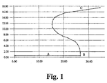
- the road shown in Fig. 1 begins at the bottom left and runs over points A, B. to point C.
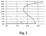
- Fig. 2 are equidistant for the road shown in Fig. 1 by linear interpolation Path points calculated and shown as black points.
- FIG. 3 shows a section of FIG. 2, the railway line of the street in the area of path point B and the dashed guide line in the same Area. From path point B and five in front and one behind The points of focus were won in each case, the used ones Path points were considered to be points of equal mass.
- the double arrow points to path point B and the associated guideline point.
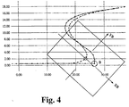
- FIG. 4 shows the image field with the axes XB, YB, the image field vertical YB in the direction of the tangent of the guide line at the respective guide point lies.
- the point of origin of the image field is located as a position point in the leadership point.
- the invention advantageously fulfills the requirements for calculating the mean Direction in the following way:
- the guideline intersects the curves and angles of the road more or more less and less curvature.
- the image field contains a representation of the course of the road in the middle local Direction, and the display is without jumps.
- the orientation of the display adapts continuously while driving, because A corresponding guide point is available for each location of the vehicle.
- the smoothing is as shown Distance range adjustable.
Landscapes
- Engineering & Computer Science (AREA)
- Radar, Positioning & Navigation (AREA)
- Remote Sensing (AREA)
- Automation & Control Theory (AREA)
- Physics & Mathematics (AREA)
- General Physics & Mathematics (AREA)
- Navigation (AREA)
- Processing Or Creating Images (AREA)
- Train Traffic Observation, Control, And Security (AREA)
Applications Claiming Priority (2)
| Application Number | Priority Date | Filing Date | Title |
|---|---|---|---|
| DE1999133503 DE19933503A1 (de) | 1999-07-16 | 1999-07-16 | Verfahren zur grafischen Darstellung einer vorausliegenden Straße |
| DE19933503 | 1999-07-16 |
Publications (3)
| Publication Number | Publication Date |
|---|---|
| EP1069403A2 true EP1069403A2 (fr) | 2001-01-17 |
| EP1069403A3 EP1069403A3 (fr) | 2003-10-22 |
| EP1069403B1 EP1069403B1 (fr) | 2015-05-13 |
Family
ID=7915089
Family Applications (1)
| Application Number | Title | Priority Date | Filing Date |
|---|---|---|---|
| EP20000115354 Expired - Lifetime EP1069403B1 (fr) | 1999-07-16 | 2000-07-14 | Procédé pour représenter graphiquement une route à venir |
Country Status (2)
| Country | Link |
|---|---|
| EP (1) | EP1069403B1 (fr) |
| DE (1) | DE19933503A1 (fr) |
Family Cites Families (4)
| Publication number | Priority date | Publication date | Assignee | Title |
|---|---|---|---|---|
| JPH07257228A (ja) * | 1994-03-18 | 1995-10-09 | Nissan Motor Co Ltd | 車両用表示装置 |
| JPH08254436A (ja) * | 1995-01-20 | 1996-10-01 | Mitsubishi Electric Corp | ナビゲーション装置 |
| US5874905A (en) * | 1995-08-25 | 1999-02-23 | Aisin Aw Co., Ltd. | Navigation system for vehicles |
| DE19738764A1 (de) * | 1997-09-04 | 1999-03-11 | Bayerische Motoren Werke Ag | Vorrichtung zur graphischen Darstellung einer vorausliegenden Straße |
-
1999
- 1999-07-16 DE DE1999133503 patent/DE19933503A1/de not_active Ceased
-
2000
- 2000-07-14 EP EP20000115354 patent/EP1069403B1/fr not_active Expired - Lifetime
Also Published As
| Publication number | Publication date |
|---|---|
| EP1069403A3 (fr) | 2003-10-22 |
| EP1069403B1 (fr) | 2015-05-13 |
| DE19933503A1 (de) | 2001-01-25 |
Similar Documents
| Publication | Publication Date | Title |
|---|---|---|
| DE60200382T2 (de) | Darstellung der Krümmung geographischer Merkmale mit Hilfe von Biegekoeffizienten | |
| DE102013105046B9 (de) | Zielspurauswahlverfahren mittels Navigationseingabe in Straßenwechselszenarien | |
| DE102005031409B4 (de) | Fahrzeugnavigationssystem und Computerprogrammprodukt | |
| EP2641057B1 (fr) | Procédé d'affichage d'instructions de navigation | |
| EP0942403B1 (fr) | Méthode et dispositif pour la représentation d'informations pour un appareil de navigation | |
| DE10146744A1 (de) | Verfahren und System zum Bereitstellen von Fahrspurempfehlungen | |
| DE102006015719A1 (de) | Navigationssystem und Programm | |
| DE4405771C2 (de) | Navigationssystem mit einem Routenbestimmungsverfahren zum schnellen und genauen Bestimmen einer gewünschten Route | |
| DE102008003395A1 (de) | Verfahren zum Betrieb eines Navigationssystems | |
| EP1886093B1 (fr) | Procede pour determiner la geometrie d'un tronçon de route | |
| EP1957940B1 (fr) | Procede de navigation pour au moins un moyen de deplacement | |
| EP3649434B1 (fr) | Procédé et dispositif pour afficher des informations concernant des voies de circulation dans un véhicule | |
| DE102010029822A1 (de) | Kraftfahrzeug mit einem Navigationssystem | |
| EP1873493B1 (fr) | Procédé destiné à la détermination automatique par ordinateur d'une route adaptée aux véhicules | |
| DE102004063034A1 (de) | Navigationsvorrichtung | |
| DE102014209751A1 (de) | Anzeige von Manöverhinweisen für eine Fahrtroute | |
| DE102011083370A1 (de) | Verfahren und Vorrichtung zum Bestimmen einer zu bevorzugenden Route aus einer Mehrzahl von Routen zwischen einem Startpunkt und einem Zielpunkt | |
| DE102009046855A1 (de) | Verfahren und Navigationsgerät zum Bereitstellen von Zusatzdaten in einer digitalen Straßenkarte | |
| DE102022130172A1 (de) | Verfahren und Fahrerassistenzsystem zur Unterstützung eines Fahrers beim Fahren in einem Proximitätsbereich einer Trajektorie | |
| WO2023138822A1 (fr) | Dispositif et procédé permettant de déterminer un profil de référence | |
| EP2028445A2 (fr) | Procédé et dispositif de détermination d'un itinéraire dans un réseau routier | |
| EP1069403B1 (fr) | Procédé pour représenter graphiquement une route à venir | |
| EP1309836B1 (fr) | Procede de representation d'un itineraire | |
| EP1069406B1 (fr) | Méthode pour la représentation graphique d'une rue à l'avance | |
| EP1255092B1 (fr) | Dispositif et procédé pour afficher de l'information dans un véhicule |
Legal Events
| Date | Code | Title | Description |
|---|---|---|---|
| PUAI | Public reference made under article 153(3) epc to a published international application that has entered the european phase |
Free format text: ORIGINAL CODE: 0009012 |
|
| AK | Designated contracting states |
Kind code of ref document: A2 Designated state(s): AT BE CH CY DE DK ES FI FR GB GR IE IT LI LU MC NL PT SE |
|
| AX | Request for extension of the european patent |
Free format text: AL;LT;LV;MK;RO;SI |
|
| PUAL | Search report despatched |
Free format text: ORIGINAL CODE: 0009013 |
|
| AK | Designated contracting states |
Kind code of ref document: A3 Designated state(s): AT BE CH CY DE DK ES FI FR GB GR IE IT LI LU MC NL PT SE |
|
| AX | Request for extension of the european patent |
Extension state: AL LT LV MK RO SI |
|
| RIC1 | Information provided on ipc code assigned before grant |
Ipc: 7G 01C 7/04 A Ipc: 7G 01C 21/34 B |
|
| 17P | Request for examination filed |
Effective date: 20031113 |
|
| AKX | Designation fees paid |
Designated state(s): DE FR GB IT |
|
| 17Q | First examination report despatched |
Effective date: 20071213 |
|
| RAP1 | Party data changed (applicant data changed or rights of an application transferred) |
Owner name: BAYERISCHE MOTOREN WERKE AKTIENGESELLSCHAFT |
|
| REG | Reference to a national code |
Ref country code: DE Ref legal event code: R079 Ref document number: 50016405 Country of ref document: DE Free format text: PREVIOUS MAIN CLASS: G01C0007040000 Ipc: G01C0021360000 |
|
| GRAP | Despatch of communication of intention to grant a patent |
Free format text: ORIGINAL CODE: EPIDOSNIGR1 |
|
| RIC1 | Information provided on ipc code assigned before grant |
Ipc: G01C 21/36 20060101AFI20141125BHEP |
|
| INTG | Intention to grant announced |
Effective date: 20141223 |
|
| GRAS | Grant fee paid |
Free format text: ORIGINAL CODE: EPIDOSNIGR3 |
|
| GRAA | (expected) grant |
Free format text: ORIGINAL CODE: 0009210 |
|
| AK | Designated contracting states |
Kind code of ref document: B1 Designated state(s): DE FR GB IT |
|
| REG | Reference to a national code |
Ref country code: GB Ref legal event code: FG4D Free format text: NOT ENGLISH |
|
| REG | Reference to a national code |
Ref country code: DE Ref legal event code: R096 Ref document number: 50016405 Country of ref document: DE Effective date: 20150625 |
|
| REG | Reference to a national code |
Ref country code: DE Ref legal event code: R097 Ref document number: 50016405 Country of ref document: DE |
|
| PLBE | No opposition filed within time limit |
Free format text: ORIGINAL CODE: 0009261 |
|
| STAA | Information on the status of an ep patent application or granted ep patent |
Free format text: STATUS: NO OPPOSITION FILED WITHIN TIME LIMIT |
|
| 26N | No opposition filed |
Effective date: 20160216 |
|
| PG25 | Lapsed in a contracting state [announced via postgrant information from national office to epo] |
Ref country code: IT Free format text: LAPSE BECAUSE OF FAILURE TO SUBMIT A TRANSLATION OF THE DESCRIPTION OR TO PAY THE FEE WITHIN THE PRESCRIBED TIME-LIMIT Effective date: 20150513 |
|
| REG | Reference to a national code |
Ref country code: FR Ref legal event code: PLFP Year of fee payment: 17 |
|
| PGFP | Annual fee paid to national office [announced via postgrant information from national office to epo] |
Ref country code: GB Payment date: 20160722 Year of fee payment: 17 Ref country code: DE Payment date: 20160726 Year of fee payment: 17 |
|
| PGFP | Annual fee paid to national office [announced via postgrant information from national office to epo] |
Ref country code: FR Payment date: 20160722 Year of fee payment: 17 |
|
| REG | Reference to a national code |
Ref country code: DE Ref legal event code: R119 Ref document number: 50016405 Country of ref document: DE |
|
| GBPC | Gb: european patent ceased through non-payment of renewal fee |
Effective date: 20170714 |
|
| REG | Reference to a national code |
Ref country code: FR Ref legal event code: ST Effective date: 20180330 |
|
| PG25 | Lapsed in a contracting state [announced via postgrant information from national office to epo] |
Ref country code: DE Free format text: LAPSE BECAUSE OF NON-PAYMENT OF DUE FEES Effective date: 20180201 Ref country code: GB Free format text: LAPSE BECAUSE OF NON-PAYMENT OF DUE FEES Effective date: 20170714 |
|
| PG25 | Lapsed in a contracting state [announced via postgrant information from national office to epo] |
Ref country code: FR Free format text: LAPSE BECAUSE OF NON-PAYMENT OF DUE FEES Effective date: 20170731 |