EP1245017B1 - Procede pour decrire et produire des reseaux routiers et reseau routier correspondant - Google Patents
Procede pour decrire et produire des reseaux routiers et reseau routier correspondant Download PDFInfo
- Publication number
- EP1245017B1 EP1245017B1 EP00977460A EP00977460A EP1245017B1 EP 1245017 B1 EP1245017 B1 EP 1245017B1 EP 00977460 A EP00977460 A EP 00977460A EP 00977460 A EP00977460 A EP 00977460A EP 1245017 B1 EP1245017 B1 EP 1245017B1
- Authority
- EP
- European Patent Office
- Prior art keywords
- traffic information
- nodes
- points
- node
- network
- Prior art date
- Legal status (The legal status is an assumption and is not a legal conclusion. Google has not performed a legal analysis and makes no representation as to the accuracy of the status listed.)
- Expired - Lifetime
Links
- 238000000034 method Methods 0.000 title claims abstract description 25
- 238000004891 communication Methods 0.000 claims abstract description 5
- 238000001514 detection method Methods 0.000 claims description 7
- 230000003068 static effect Effects 0.000 claims description 4
- 230000033001 locomotion Effects 0.000 claims description 3
- 230000001360 synchronised effect Effects 0.000 description 8
- 230000005540 biological transmission Effects 0.000 description 5
- 230000002123 temporal effect Effects 0.000 description 3
- 230000004807 localization Effects 0.000 description 2
- 230000006978 adaptation Effects 0.000 description 1
- 230000002457 bidirectional effect Effects 0.000 description 1
- 150000001875 compounds Chemical class 0.000 description 1
- 230000001419 dependent effect Effects 0.000 description 1
- 238000011161 development Methods 0.000 description 1
- 230000018109 developmental process Effects 0.000 description 1
- 238000010586 diagram Methods 0.000 description 1
- 238000012545 processing Methods 0.000 description 1
- 238000012797 qualification Methods 0.000 description 1
- 238000012549 training Methods 0.000 description 1
- 230000007704 transition Effects 0.000 description 1
Images



Classifications
-
- G—PHYSICS
- G08—SIGNALLING
- G08G—TRAFFIC CONTROL SYSTEMS
- G08G1/00—Traffic control systems for road vehicles
- G08G1/01—Detecting movement of traffic to be counted or controlled
-
- G—PHYSICS
- G09—EDUCATION; CRYPTOGRAPHY; DISPLAY; ADVERTISING; SEALS
- G09B—EDUCATIONAL OR DEMONSTRATION APPLIANCES; APPLIANCES FOR TEACHING, OR COMMUNICATING WITH, THE BLIND, DEAF OR MUTE; MODELS; PLANETARIA; GLOBES; MAPS; DIAGRAMS
- G09B29/00—Maps; Plans; Charts; Diagrams, e.g. route diagram
- G09B29/003—Maps
- G09B29/006—Representation of non-cartographic information on maps, e.g. population distribution, wind direction, radiation levels, air and sea routes
Definitions
- the invention relates to a method for describing and generating road networks for the determination of traffic information or traffic status data and / or the Determination of travel times on routes or route sections by at least one mobile detector, in particular a vehicle, wherein the mobile detector a Position determining device and a device for data communication with a central office and, a road network for the determination of Traffic information and / or the determination of travel times by at least one mobile detector, in particular a vehicle.
- From the German patent application DE 197 50 775 A1 discloses a method for Selecting traffic information sent from a control panel and a route of a vehicle, known.
- the route is in the form of Waypoints between a starting point and a destination point in the transport network determined and the selection of relevant traffic information is done by between each two waypoints a zone is defined and a location in the zone relevant traffic information is selected as relevant while a place Outside the zone traffic information defined as not relevant become.
- the zone becomes a corridor between two parallels to one Connecting line between two waypoints with predetermined or predefinable Distance to the connecting line defined.
- German patent application DE 197 53 170 A1 discloses a method for Transmission of a recommended route of a vehicle in a traffic network relevant route information from a traffic center to a terminal in one Vehicle described in which the route information on the route of the vehicle refer to lying waypoints, with a waypoint each defined at a location becomes, at which the vehicle can continue in several directions.
- To each Waypoint are the place of the waypoint determining location data, the Crossing geometry of the waypoint related geometry data and the route transmit transition data defining the waypoint.
- German patent application DE 196 43 454 A1 a method for the transmission of traffic situation assessment data.
- data for traffic situation assessment in sections a road network and transmitted to a central office To judge the Traffic situation is further provided that from the detected sensor data in the vehicle in each case a current driving profile is formed and from the current driving profile characteristic properties are derived in the sense of actual values.
- Farther become characteristic in the vehicle on the basis of given traffic situation information
- German patent application DE 197 50 774 A1 discloses a method for Transmission of a traffic network, representing the traffic situation Traffic information from a traffic center to a terminal of a vehicle described, wherein at least one route of the transport network concerned Traffic information is transmitted to each segment of the route at least under predetermined qualification of the traffic situation in the form of representing qualified speeds in the track segments Speeds.
- the document EP 0 902 406 A2 discloses a method for Transmission of route data, in particular by mobile, between a vehicle and a central office, wherein route data is transmitted are given names of one or more adjacent edges comprising partial paths, wherein at least some partial paths comprise several edges.
- the document EP o 889 454 A2 shows a method for the analysis of a traffic network having edges and nodes, that in the form of at least information about compounds of Nodes and / or comprehensive by edge ends, the spatial structure of the transport network representative output file is present.
- the road network is essentially by junctions described, for example, at intersections, motorway junctions, motorway triangles, Connection points, but also to rest areas or parking lots are set.
- contour points are introduced on the route, which preferably the describe the geographical location of a link.
- a link is preferably a connection between two nodes.
- Sync points are in one specific distance from a node on the link. This distance will preferably by the node geometry, in particular the number and the angle of the outgoing links, determined and is freely selectable.
- Sync points are used for detection a link traveled by the mobile detector or for determining on which part the asynchronous traffic status messages from the mobile detector to the link Central office to be sent.
- the circles of node, contour or synchronous points do not cover.
- individual tight adjacent node and / or contour points each as a node or Contour point are defined with comprehensive node perimeter.
- comprehensive Node circumference can thus detect more complex intersections with a central node which will reduce the complexity of the road network.
- Another embodiment of the invention provides that links, so the connection between node, contour and / or sync points, as an alley or corridor of Coordinates, preferably with a width equal to the diameter of the circles of Synchronous points corresponds, are defined.
- the left detection, d. H. on which link the mobile detector is located takes place by means of the last passed through node and the after reached synchronization point.
- Node, contour, and / or sync points, and thus links should also be included changeable, addable, deletable, time-activatable and / or deactivatable and / or be displaceable.
- nodes and / or the Left static and / or dynamic attributes in particular the road type and / or the type of road or medium speed, has.
- a preferred embodiment of the invention provides that the determination and / or Change or adaptation of the road network at the headquarters takes place and Traffic status detection and / or driving time determination on sections of a route the mobile detector is sent.
- the road network in one Device of the mobile detector is stored.
- A, in particular synchronous traffic status determination is preferably carried out at Reaching the end of the link. This is done by adding at the end of each link Comparison of detected and / or detected while driving the link Motion parameters of the mobile detector with stored for the link Reference values and a message when a predefined difference occurs from the mobile detector to the central office.
- the generation of the road network according to the invention is preferably carried out in a data processing device, wherein by means of a digitized road map of the real road network set node contour and sync points and thus also the individual links are defined and saved.
- the generated data records can be available following any number of mobile detectors be put.
- Fig. 1 is a system for detecting traffic information and / or the Travel times on one of at least one mobile detector 1, in particular a Motor vehicle, traveled route shown.
- the mobile detector 1 which has a position determining device for determining the geographical coordinates of its current location, preferably one Satellite-based detection device 2, and at least one device 6 for Data communication with a central office 3, sends in the simplest case continuously its geographical coordinates to the central office 3, which from the temporal Change of geographical coordinates Traffic conditions and travel times determined. In other cases, are recorded by on-board sensors Movement data evaluated by the mobile sensor 1 and, for example, depending a comparison with expected values sent to the center 3. Such procedures are for example from DE 195 13 640 C2, DE 196 43 454 A1 or WO 98/36397 known. The problem with these methods is that the mobile Sensor 1 only its geographical position, but not its position in the actual Transport network knows. There is a risk of false reports or one large number of no or only slightly relevant traffic status messages.
- the traffic information detection network 5 which is permanently stored in the mobile detector 1, with changes or adjustments, so-called up-date's of the center 3 via the data communication link 4, which is bidirectional in this case, to the mobile Detectors 1 are sent. It is conceivable that the stored road network or parts thereof have only a temporal validity, for example, that in traffic rush hours another network has validity, as on Sundays and public holidays.
- the traffic network 5, which serves as the basis for the traffic information determination, is stored as a network of a number of links St and a number of nodes Kp (FIG. 2), where at relevant points of the traffic network relevant for the traffic status determination, such as road intersections, Motorway intersections, triangles, junctions nodes Kp are defined and stored.
- nodes Kp can also be introduced at motorway rest stops and parking lots.
- the nodes Kp also represent start and end points of links St, respectively. If the distance between adjacent nodes Kp and thus the connecting links St exceeds the average length substantially, expectant contour points Kop are introduced.
- the contour points Kop serve to approximate a link St to the real road course. This approximation is achieved with an average of five contour points Kop between two nodes Kp, which describe the geopraphic position of the links St.
- For generating the contour points Kop the extreme points of a road course are determined. For this purpose, a virtual airline connection between two nodes Kp is formed.
- the largest distance of the road to this virtual airline connection as well as the intersections with the airline connection is determined. If the road has no intersection with the straight-line connection, maxima and minima are determined alternately.
- the contour points Kop can now be determined from these described extremes. If there are more extremes than contour points Kop are to be set, a decision is made as to whether each of the largest absolute values in terms of magnitude is set as contour points Kop or whether an additional node Kp is inserted.
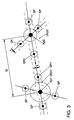
- synchronous points SP are introduced as shown in FIG.
- the synchronization points SP are at predetermined distances from the node Kp on the link St. These distances are due to the local conditions, such as turning lanes, the angles of the roads leaving the real intersection KR and the links St from the intersection Kp and the complexity of the intersection determined in itself and are freely selectable.
- the synchronization points SP serve on the one hand to delimit an area around the node Kp, in which asynchronous traffic status messages are excluded, and on the other hand make the clear assignment of the traveled link St possible.
- the message of a detected asynchronous traffic condition is released only when reaching the node Kp1 following start synchronization point SP1 on the link St.
- Asynchronous traffic conditions include traffic jams with very long traffic jams or road blocks.
- the end synchronization point SP2 is reached, an asynchronous message is disabled.
- the message of a synchronous traffic condition such as a classic stop-and-go situation, only at the end of the link St, deposited at the node Kp2 to the headquarters.
- each link must be a St Start synchronization point SP1 have.
- the position determining device of the mobile Detector identifies the start synchronization point SP1 following the node Kp1 Driving direction and can make the assignment to a link clearly.
- the nodes Kp, but also the contour Kop and synchronization points SP are through constant coordinates are determined as points. To avoid inaccuracies in the Position determination, especially in a satellite-based Positioning occur, compensate, are around the nodes Kp orbits Ukp or Fangradien arranged. Such circuits Ukp can despite that in the Embodiment is not provided, even to the contour Kop or Synchronous points SP are arranged. All determined positions of the mobile Detectors with co-ordinates that are in the vicinity then become the respective ones Point duly counted. The dimensions of the circles Ukp or Fangradien must adapted to the particular local conditions of the actual street scene become.
- the perimeter Ukp with a fixed default value for example, the inaccuracy of Position determining device corresponds to be occupied. But as soon as intersections become more complex and more outgoing roads, ramps or intermediate pieces , the perimeter Ukp must be determined accordingly. This is by all Roads that pass the node Kp, the minimum distance to the node Kp determined. The largest of these distances s results in addition to the Inaccuracy su the position detector of the mobile detector the Radius of the circumference (Fig.4). The maximum radius is set to a specific value set, that is, the largest of the determined distances s may be in addition to the largest Inaccuracy su the position determination device does not exceed this value. If this is the case, the intersection with several nodes Kp is detected.
- the road network described for the determination and forwarding of traffic conditions and / or driving time should not be static, but designed dynamically and to the respective traffic and thus to the relevance of Traffic status messages as well as changing spatial and temporal Framework conditions and special requirements, for example, the customers of Traffic information, be adaptable.
- Each link of the road network according to the invention can at any time according to the Demand can be activated or deactivated, for example on low-traffic times as well as daily, Ranzeit- and season-dependent.
- links St different functions or attributes are assigned, so links can only be used for asynchronous traffic status messages or for asynchronous ones Status messages provided within the road network according to the invention become.
Landscapes
- Physics & Mathematics (AREA)
- Engineering & Computer Science (AREA)
- General Physics & Mathematics (AREA)
- Theoretical Computer Science (AREA)
- Ecology (AREA)
- Mathematical Physics (AREA)
- Business, Economics & Management (AREA)
- Educational Administration (AREA)
- Educational Technology (AREA)
- Life Sciences & Earth Sciences (AREA)
- Traffic Control Systems (AREA)
- Navigation (AREA)
- Mobile Radio Communication Systems (AREA)
- Instructional Devices (AREA)
Claims (26)
- Procédé pour décrire et produire une image de réseaux routiers sous la forme d'un réseau d'acquisition d'informations de trafic (5) pour l'évaluation d'informations de trafic et/ou l'évaluation de temps de trajet, avec lequel des données géographiques sont détectées au moyen d'un dispositif de détermination de la position (2) d'au moins un détecteur mobile (1), notamment d'un véhicule, une transmission de données peut être effectuée et/ou est effectuée entre le détecteur (1) et une centrale (3), le réseau routier réel ou des parties du réseau routier réel sont décrits dans le réseau d'acquisition d'informations de trafic par des points nodaux (Kp) et des liaisons (St) qui relient les points nodaux (Kp), caractérisé en ce que des points de synchronisation (SP) sont fixés au moins sur une partie des liaisons (St) vers un point nodal (Kp) décrivant une intersection à des distances à chaque fois prédéfinies, et la détection de la liaison (St) sur laquelle se trouve le détecteur mobile s'effectue au moyen du dernier point nodal (Kp) franchi et du point de synchronisation atteint ensuite.
- Procédé selon la revendication 1, caractérisé en ce que la distance entre le point de synchronisation (SP) et le point nodal (Kp) est déterminée par la forme géométrique du noeud du point nodal (Kp), laquelle est prédéfinie par le réseau routier réel.
- Procédé selon l'une des revendications précédentes, caractérisé en ce qu'une liaison (St) entre deux points nodaux (Kp) est approchée du tracé des routes du réseau routier réel en introduisant des points de contournement (Kop) si la liaison entre ces deux points nodaux (Kp) dépasse une longueur préalablement définie.
- Procédé selon la revendication 3, caractérisé en ce que les points de contournement (Kop) d'une liaison (St) sont définis par le fait que les écarts extrêmes par rapport à une ligne à vol d'oiseau entre deux points nodaux (Kp) sont déterminés à partir du tracé réel de la route.
- Procédé selon la revendication 3 ou 4, caractérisé en ce qu'un point de synchronisation (SP) est un point de contournement (Kop) qui suit un point nodal (Kp) sur une liaison (St).
- Procédé selon la revendication 1, caractérisé en ce que les points nodaux (Kp), les points de contournement (Kop) et les points de synchronisation (SP) sont à chaque fois déterminés par des coordonnées géographiques constantes en tant que points qui présentent à chaque fois une circonférence (Ukp, Ukop, USP) déterminée par une plage de coordonnées, les cordonnées de la plage de coordonnées correspondante étant évaluées en association avec les cordonnées constantes du point nodal (Kp) correspondant ou du point de contournement (Kop) correspondant ou du point de synchronisation (SP) correspondant.
- Procédé selon la revendication 6, caractérisé en ce que les dimensions des circonférences (Ukp, Ukop, USP) sont déterminées par la forme géométrique du noeud qui est prédéfinie par le réseau routier réel.
- Procédé selon la revendication 6 ou 7, caractérisé en ce que les dimensions des circonférences (Ukp, Ukop, USP) sont déterminées par la vitesse moyenne à la quelle est empruntée la circonférence correspondante.
- Procédé selon l'une des revendications 1 à 8, caractérisé en ce que des deux côtés d'une liaison est formée une voie qui comprend des coordonnées géographiques qui se trouvent au sein d'un écart donné par rapport à la liaison (St), le fait de quitter la liaison (St) étant détecté par le fait de quitter la voie.
- Procédé selon l'une des revendications 1 à 9, caractérisé en ce que les points nodaux (Kp), les points de contournement (Kop) et/ou les points de synchronisation (SP) peuvent être modifiés, ajoutés, supprimés, activés dans le temps et/ou désactivés dans le temps et/ou déplacés.
- Procédé selon l'une des revendications 1 à 10, caractérisé en ce qu'au moins une partie des poins nodaux (Kp) et/ou des liaisons (St) présente des attributs statiques et/ou dynamiques du réseau routier réel.
- Procédé selon l'une des revendications 1 à 11, caractérisé en ce qu'une détection de l'état du trafic est effectuée lorsque le détecteur mobile (1) atteint la fin de la liaison (St).
- Procédé selon la revendication 12, caractérisé en ce qu'à la fin de chaque liaison a lieu une comparaison entre les paramètres de déplacement du détecteur mobile déterminés ou détectés pendant le parcours de la liaison (SP) et des valeurs de référence enregistrées pour la liaison et, en présence d'une différence prédéfinie, un message est envoyé du détecteur mobile (1) vers la centrale (3).
- Réseau d'acquisition d'informations de trafic (5) représentant un réseau routier réel pour l'évaluation d'informations de trafic et/ou l'évaluation de temps de trajet dans un réseau routier réel par le biais d'au moins un détecteur mobile (1), notamment un véhicule, le réseau d'informations de trafic représentant au moins partiellement une image du réseau routier réel, le réseau routier réel ou des parties du réseau routier réel sont décrits par des points nodaux (Kp) et des liaisons (St) qui relient les points nodaux (Kp) au sein du réseau d'acquisition d'informations de trafic, caractérisé en ce que des points de synchronisation (SP) sont fixés au moins sur une partie des liaisons vers un point nodal (Kp) décrivant une intersection à des distances à chaque fois prédéfinies, que la détection de la liaison (St) sur laquelle se trouve le détecteur mobile s'effectue au moyen du dernier point nodal (Kp) franchi et du point de synchronisation atteint ensuite.
- Réseau d'acquisition d'informations de trafic (5) selon la revendication 14, caractérisé en ce que la distance entre un point de synchronisation (SP) et le point nodal (Kp) est déterminée par la forme géométrique du point nodal (Kp), laquelle est prédéfinie par le réseau routier réel.
- Réseau d'acquisition d'informations de trafic (5) selon l'une des revendications 14 à 15, caractérisé en ce qu'une liaison (St) entre deux points nodaux (Kp) est approchée du tracé des routes du réseau routier réel en introduisant des points de contournement (Kop) si la liaison entre les deux points nodaux (Kp) dépasse une longueur préalablement définie.
- Réseau d'acquisition d'informations de trafic (5) selon la revendication 16, caractérisé en ce qu'un point de synchronisation (SP) est un point de contournement (Kop) qui suit un point nodal (Kp) sur une liaison (St).
- Réseau d'acquisition d'informations de trafic (5) selon l'une des revendication 16 à 17, caractérisé en ce que les points nodaux (Kp) et/ou les points de contournement (Kop) et/ou les points de synchronisation (SP) sont à chaque fois déterminés par des coordonnées géographiques constantes en tant que points qui présentent à chaque fois une circonférence (Ukp, Ukop, USP) déterminée par une plage de coordonnées, les cordonnées de la plage de coordonnées correspondante étant évaluées en association avec les cordonnées constantes du point nodal (Kp) correspondant ou du point de contournement (Kop) correspondant ou du point de synchronisation (SP) correspondant.
- Réseau d'acquisition d'informations de trafic (5) selon la revendication 18, caractérisé en ce que les dimensions des circonférences (Ukp, Ukop, USP) sont déterminées par la forme géométrique du noeud qui est prédéfinie par le réseau routier réel.
- Réseau d'acquisition d'informations de trafic (5) selon la revendication 18 ou 19, caractérisé en ce que les dimensions des circonférences (Ukp, Ukop, USP) sont déterminées par la vitesse moyenne à la quelle est empruntée la circonférence correspondante.
- Réseau d'acquisition d'informations de trafic (5) selon l'une des revendications 18 à 20, caractérisé en ce que les dimensions des circonférences (Ukp, Ukop, USP) des points nodaux (Kp) et/ou des points de contournement (Kop) et/ou des points de synchronisation (SP) peuvent être modifiées par la centrale (3).
- Réseau d'acquisition d'informations de trafic (5) selon l'une des revendications 18 à 21, caractérisé en ce que les circonférences (Ukp, Ukop, USP) des points nodaux (Kp), des points de contournement (Kop) et des points de synchronisation (SP) ne se chevauchent pas.
- Réseau d'acquisition d'informations de trafic (5) selon l'une des revendications 14 à 22, caractérisé en ce que des deux côtés d'une liaison (St) est formée une voie qui comprend des coordonnées qui se trouvent au sein d'un écart donné par rapport à une liaison (St).
- Réseau d'acquisition d'informations de trafic (5) selon l'une des revendications 14 à 23, caractérisé en ce que les points nodaux (Kp) et/ou les points de contournement (Kop) et/ou les points de synchronisation (SP) peuvent être ajoutés, supprimés, activés dans le temps et/ou désactivés dans le temps et/ou déplacés.
- Réseau d'acquisition d'informations de trafic (5) selon l'une des revendications 14 à 24, caractérisé en ce qu'au moins une partie des poins nodaux (Kp) et/ou des liaisons (St) présente les données des attributs statiques et/ou dynamiques du réseau routier réel.
- Réseau d'acquisition d'informations de trafic (5) selon l'une des revendications 14 à 25, caractérisé en ce que le réseau d'acquisition d'informations de trafic (5) peut être logé ou est logé dans un dispositif d'un détecteur mobile.
Applications Claiming Priority (5)
| Application Number | Priority Date | Filing Date | Title |
|---|---|---|---|
| DE19954498 | 1999-11-11 | ||
| DE19954498 | 1999-11-11 | ||
| DE10052109 | 2000-10-20 | ||
| DE10052109.6A DE10052109B4 (de) | 1999-11-11 | 2000-10-20 | Verfahren zum Beschreiben und Erzeugen von Straßennetzen und Straßennetz |
| PCT/EP2000/010790 WO2001035370A1 (fr) | 1999-11-11 | 2000-11-02 | Procede pour decrire et produire des reseaux routiers et reseau routier correspondant |
Publications (2)
| Publication Number | Publication Date |
|---|---|
| EP1245017A1 EP1245017A1 (fr) | 2002-10-02 |
| EP1245017B1 true EP1245017B1 (fr) | 2005-07-06 |
Family
ID=26007439
Family Applications (1)
| Application Number | Title | Priority Date | Filing Date |
|---|---|---|---|
| EP00977460A Expired - Lifetime EP1245017B1 (fr) | 1999-11-11 | 2000-11-02 | Procede pour decrire et produire des reseaux routiers et reseau routier correspondant |
Country Status (6)
| Country | Link |
|---|---|
| US (1) | US6850840B1 (fr) |
| EP (1) | EP1245017B1 (fr) |
| JP (1) | JP2003514238A (fr) |
| AT (1) | ATE299284T1 (fr) |
| AU (1) | AU1517101A (fr) |
| WO (1) | WO2001035370A1 (fr) |
Families Citing this family (13)
| Publication number | Priority date | Publication date | Assignee | Title |
|---|---|---|---|---|
| EP1830478B1 (fr) * | 1998-03-26 | 2008-12-10 | Mitsubishi Denki Kabushiki Kaisha | Procédé de communication à spectre étalé |
| US6587781B2 (en) | 2000-08-28 | 2003-07-01 | Estimotion, Inc. | Method and system for modeling and processing vehicular traffic data and information and applying thereof |
| JP4749594B2 (ja) * | 2001-04-27 | 2011-08-17 | パナソニック株式会社 | デジタル地図の位置情報伝達方法 |
| US7620402B2 (en) | 2004-07-09 | 2009-11-17 | Itis Uk Limited | System and method for geographically locating a mobile device |
| AU2005100125B4 (en) * | 2005-02-11 | 2006-11-30 | Mojarrabi, Bahram Mr | Scale free network of urban traffic |
| JP2007079653A (ja) * | 2005-09-12 | 2007-03-29 | Japan Radio Co Ltd | 道路情報ガイダンス方法およびシステム |
| KR100822010B1 (ko) * | 2006-11-30 | 2008-04-15 | 에스케이에너지 주식회사 | 교통정보 수집용 수치지도를 이용한 교통정보 제공 시스템및 방법 |
| US7447588B1 (en) | 2007-07-16 | 2008-11-04 | Wenshine Technology Ltd. | Method and system for partitioning a continental roadway network for an intelligent vehicle highway system |
| GB0901588D0 (en) | 2009-02-02 | 2009-03-11 | Itis Holdings Plc | Apparatus and methods for providing journey information |
| GB2492369B (en) | 2011-06-29 | 2014-04-02 | Itis Holdings Plc | Method and system for collecting traffic data |
| TW201327458A (zh) * | 2011-12-29 | 2013-07-01 | Chunghwa Telecom Co Ltd | 一種應用車輛探測資料之交通路網生成方法 |
| US9453734B2 (en) * | 2012-06-05 | 2016-09-27 | Apple Inc. | Smart loading of map tiles |
| US9122702B2 (en) * | 2012-10-16 | 2015-09-01 | Nokia Technologies Oy | Method and apparatus for providing location trajectory compression based on map structure |
Family Cites Families (17)
| Publication number | Priority date | Publication date | Assignee | Title |
|---|---|---|---|---|
| DE19508468B4 (de) | 1994-11-25 | 2006-05-24 | Matsushita Electric Works, Ltd., Kadoma | Stromversorgungseinrichtung |
| DE19513640C2 (de) | 1994-11-28 | 1997-08-07 | Mannesmann Ag | Verfahren zur Reduzierung einer aus den Fahrzeugen einer Fahrzeugflotte zu übertragenden Datenmenge |
| JPH08249593A (ja) * | 1995-03-10 | 1996-09-27 | Honda Motor Co Ltd | 車両制御装置 |
| JP2902340B2 (ja) * | 1995-12-28 | 1999-06-07 | アルパイン株式会社 | 車両位置修正方法 |
| DE59704345D1 (de) * | 1996-03-25 | 2001-09-27 | Mannesmann Ag | Verfahren zur Referenzierung von ortsfesten Objekten |
| DE19643454C2 (de) | 1996-10-10 | 2003-08-21 | Mannesmann Ag | Verfahren und Vorrichtung zur Übermittlung von Daten zur Verkehrslagebeurteilung |
| DE19753170A1 (de) | 1996-12-16 | 1998-06-18 | Mannesmann Ag | Verfahren zur Übertragung von eine empfohlene Route eines Fahrzeuges in einem Verkehrsnetz betreffenen Routeninformationen von einer Verkehrszentrale an ein Endgerät in einem Fahrzeug, Endgerät und Zentrale |
| DE19750775B4 (de) | 1996-12-16 | 2005-08-18 | Atx Europe Gmbh | Verfahren zum Selektieren von eine Route eines Fahrzeuges mit einem Endgerät in einem Verkehrsnetz betreffenden, von einer Zentrale ausgesendeten Verkehrsinformationen, Endgerät und Zentrale zum Durchführen des Verfahrens |
| DE19750774A1 (de) | 1996-12-16 | 1998-07-23 | Mannesmann Ag | Verfahren und Vorrichtung zum Übermitteln von ein Verkehrsnetz betreffenden, die Verkehrssituation repräsentierenden Verkehrsinformationen von einer Verkehrszentrale an ein Endgerät eines Fahrzeuges |
| WO1998036397A1 (fr) | 1997-02-14 | 1998-08-20 | Mannesmann Ag | Procede de determination de donnees relatives au trafic et central d'information sur le trafic |
| DE19729914A1 (de) | 1997-07-04 | 1999-01-07 | Mannesmann Ag | Verfahren zur Analyse eines Verkehrsnetzes, Verkehrsanalyse, Verkehrsprognose sowie Erzeugung einer historischen Verkehrsdatenbank und Verkehrsanalyse- und -prognosezentrale |
| DE19741116B4 (de) | 1997-09-12 | 2004-02-26 | Mannesmann Ag | Verfahren zur Übertragung von Wegedaten, Verfahren zur Analyse eines Verkehrswegenetzes, Verkehrserfassungszentrale und Endgerät |
| JP3525789B2 (ja) * | 1999-03-18 | 2004-05-10 | 株式会社デンソー | 車載用ナビゲーション装置 |
| CA2266208C (fr) * | 1999-03-19 | 2008-07-08 | Wenking Corp. | Systeme d'echange de donnees sur la circulation routiere a distance et de vehicules routiers intelligents |
| JP3481168B2 (ja) * | 1999-08-27 | 2003-12-22 | 松下電器産業株式会社 | デジタル地図の位置情報伝達方法 |
| JP3521817B2 (ja) * | 1999-10-26 | 2004-04-26 | 株式会社エクォス・リサーチ | ナビゲーション装置 |
| JP4479028B2 (ja) * | 1999-11-18 | 2010-06-09 | 株式会社エクォス・リサーチ | 通信型車載情報処理装置、及び通信型情報センタ |
-
2000
- 2000-11-02 US US10/129,864 patent/US6850840B1/en not_active Expired - Lifetime
- 2000-11-02 AT AT00977460T patent/ATE299284T1/de not_active IP Right Cessation
- 2000-11-02 AU AU15171/01A patent/AU1517101A/en not_active Abandoned
- 2000-11-02 EP EP00977460A patent/EP1245017B1/fr not_active Expired - Lifetime
- 2000-11-02 JP JP2001537028A patent/JP2003514238A/ja active Pending
- 2000-11-02 WO PCT/EP2000/010790 patent/WO2001035370A1/fr not_active Ceased
Also Published As
| Publication number | Publication date |
|---|---|
| JP2003514238A (ja) | 2003-04-15 |
| US6850840B1 (en) | 2005-02-01 |
| ATE299284T1 (de) | 2005-07-15 |
| EP1245017A1 (fr) | 2002-10-02 |
| AU1517101A (en) | 2001-06-06 |
| WO2001035370A1 (fr) | 2001-05-17 |
Similar Documents
| Publication | Publication Date | Title |
|---|---|---|
| EP2979261B1 (fr) | Étage de sortie pour systèmes d'aide à la conduite | |
| DE19525291C1 (de) | Verfahren und Vorrichtung zur Aktualisierung von digitalen Straßenkarten | |
| DE60201075T2 (de) | Verkehrsleitsystem mit vom verstopfungsgrad der strassen abhängenden strassenbenutzungsgebühren | |
| EP0902406B1 (fr) | Procédé de transmission de données routières et d'analyse du réseau de circulation routière, unité centrale de mesure du trafic routier et terminal associé | |
| DE102018211941B4 (de) | Verfahren zum Ermitteln einer Kreuzungstopologie einer Straßenkreuzung | |
| EP0941534B1 (fr) | Procede de determination de donnees d'itineraires | |
| DE102023001318A1 (de) | Verfahren und Vorrichtung zum assistierten Fahren eines Fahrzeugs an Kreuzungen | |
| EP1245017B1 (fr) | Procede pour decrire et produire des reseaux routiers et reseau routier correspondant | |
| EP1303845B1 (fr) | Procede de determination d'informations relatives a la situation du trafic | |
| DE102017201665A1 (de) | Verfahren zur Einbindung eines dynamischen Objektes in eine digitale Karte eines hochautomatisierten Fahrzeugs (HAF) | |
| WO2013171088A1 (fr) | Procédé et système de création d'une représentation actuelle d'une situation | |
| DE102007056225A1 (de) | Verfahren und Vorrichtung zum Steuern eines Verkehrsflusses an einer Kreuzung | |
| DE102004039854A1 (de) | Verfahren zum Ermitteln von Verkehrsinformationen, Verfahren zum Steuern des Verkehrs, sowie System zum Durchführen der Verfahren | |
| EP3688659B1 (fr) | Procédé d'identification automatisée des surfaces de stationnement et/ou des surfaces de non stationnement | |
| EP3669341B1 (fr) | Procédé, dispositif et support de stockage lisible par ordinateur avec instructions pour le traitement de données dans un véhicule automobile en vue d'un envoie à un back-end | |
| EP1281933B1 (fr) | Procédé et système pour trouver un lieu dans une carte numérique | |
| DE102008022349A1 (de) | Verfahren und Vorrichtung zur Ermittlung von Rückstaulängen an Lichtsignalanlagen | |
| EP0889454A2 (fr) | Procédé et centrale de pronostic et d'analyse d'un réseau de circulation | |
| EP1957939B1 (fr) | Dispositif et procede de fourniture d'informations de guidage vers une destination dans un systeme de navigation | |
| EP1262934B1 (fr) | Méthode pour la detection de la situation du trafic routier | |
| DE10225782B4 (de) | Verfahren zum Informieren von Verkehrsteilnehmern | |
| DE10052109B4 (de) | Verfahren zum Beschreiben und Erzeugen von Straßennetzen und Straßennetz | |
| EP3062301A1 (fr) | Procede d'attribution d'une trajectoire a un vehicule automobile et procede de commande d'un systeme de transport | |
| EP1022703B1 (fr) | Procédé d'aménagement des flux de circulation pour un contôle optimisé du trafic, de même la planification des réseaux routiers en fonction des besoins | |
| DE10234367B3 (de) | Verfahren zur Abbildung des Verkehrszustandes und System zur Verkehrsorganisation |
Legal Events
| Date | Code | Title | Description |
|---|---|---|---|
| PUAI | Public reference made under article 153(3) epc to a published international application that has entered the european phase |
Free format text: ORIGINAL CODE: 0009012 |
|
| 17P | Request for examination filed |
Effective date: 20020611 |
|
| AK | Designated contracting states |
Kind code of ref document: A1 Designated state(s): AT BE CH CY DE DK ES FI FR GB GR IE IT LI LU MC NL PT SE TR |
|
| AX | Request for extension of the european patent |
Free format text: AL;LT;LV;MK;RO;SI |
|
| 17Q | First examination report despatched |
Effective date: 20021031 |
|
| GRAP | Despatch of communication of intention to grant a patent |
Free format text: ORIGINAL CODE: EPIDOSNIGR1 |
|
| GRAS | Grant fee paid |
Free format text: ORIGINAL CODE: EPIDOSNIGR3 |
|
| GRAA | (expected) grant |
Free format text: ORIGINAL CODE: 0009210 |
|
| AK | Designated contracting states |
Kind code of ref document: B1 Designated state(s): AT BE CH CY DE DK ES FI FR GB GR IE IT LI LU MC NL PT SE TR |
|
| PG25 | Lapsed in a contracting state [announced via postgrant information from national office to epo] |
Ref country code: ES Free format text: LAPSE BECAUSE OF FAILURE TO SUBMIT A TRANSLATION OF THE DESCRIPTION OR TO PAY THE FEE WITHIN THE PRESCRIBED TIME-LIMIT Effective date: 20050706 Ref country code: TR Free format text: LAPSE BECAUSE OF FAILURE TO SUBMIT A TRANSLATION OF THE DESCRIPTION OR TO PAY THE FEE WITHIN THE PRESCRIBED TIME-LIMIT Effective date: 20050706 Ref country code: NL Free format text: LAPSE BECAUSE OF FAILURE TO SUBMIT A TRANSLATION OF THE DESCRIPTION OR TO PAY THE FEE WITHIN THE PRESCRIBED TIME-LIMIT Effective date: 20050706 Ref country code: FI Free format text: LAPSE BECAUSE OF FAILURE TO SUBMIT A TRANSLATION OF THE DESCRIPTION OR TO PAY THE FEE WITHIN THE PRESCRIBED TIME-LIMIT Effective date: 20050706 Ref country code: IE Free format text: LAPSE BECAUSE OF FAILURE TO SUBMIT A TRANSLATION OF THE DESCRIPTION OR TO PAY THE FEE WITHIN THE PRESCRIBED TIME-LIMIT Effective date: 20050706 |
|
| REG | Reference to a national code |
Ref country code: GB Ref legal event code: FG4D Free format text: NOT ENGLISH |
|
| REG | Reference to a national code |
Ref country code: CH Ref legal event code: EP |
|
| REG | Reference to a national code |
Ref country code: IE Ref legal event code: FG4D Free format text: LANGUAGE OF EP DOCUMENT: GERMAN |
|
| REF | Corresponds to: |
Ref document number: 50010682 Country of ref document: DE Date of ref document: 20050811 Kind code of ref document: P |
|
| PG25 | Lapsed in a contracting state [announced via postgrant information from national office to epo] |
Ref country code: DK Free format text: LAPSE BECAUSE OF FAILURE TO SUBMIT A TRANSLATION OF THE DESCRIPTION OR TO PAY THE FEE WITHIN THE PRESCRIBED TIME-LIMIT Effective date: 20051006 Ref country code: GR Free format text: LAPSE BECAUSE OF FAILURE TO SUBMIT A TRANSLATION OF THE DESCRIPTION OR TO PAY THE FEE WITHIN THE PRESCRIBED TIME-LIMIT Effective date: 20051006 Ref country code: SE Free format text: LAPSE BECAUSE OF FAILURE TO SUBMIT A TRANSLATION OF THE DESCRIPTION OR TO PAY THE FEE WITHIN THE PRESCRIBED TIME-LIMIT Effective date: 20051006 |
|
| GBT | Gb: translation of ep patent filed (gb section 77(6)(a)/1977) |
Effective date: 20050917 |
|
| PG25 | Lapsed in a contracting state [announced via postgrant information from national office to epo] |
Ref country code: CY Free format text: LAPSE BECAUSE OF FAILURE TO SUBMIT A TRANSLATION OF THE DESCRIPTION OR TO PAY THE FEE WITHIN THE PRESCRIBED TIME-LIMIT Effective date: 20051102 Ref country code: AT Free format text: LAPSE BECAUSE OF NON-PAYMENT OF DUE FEES Effective date: 20051102 |
|
| PG25 | Lapsed in a contracting state [announced via postgrant information from national office to epo] |
Ref country code: LU Free format text: LAPSE BECAUSE OF NON-PAYMENT OF DUE FEES Effective date: 20051130 Ref country code: MC Free format text: LAPSE BECAUSE OF NON-PAYMENT OF DUE FEES Effective date: 20051130 Ref country code: CH Free format text: LAPSE BECAUSE OF NON-PAYMENT OF DUE FEES Effective date: 20051130 Ref country code: BE Free format text: LAPSE BECAUSE OF NON-PAYMENT OF DUE FEES Effective date: 20051130 Ref country code: LI Free format text: LAPSE BECAUSE OF NON-PAYMENT OF DUE FEES Effective date: 20051130 |
|
| PG25 | Lapsed in a contracting state [announced via postgrant information from national office to epo] |
Ref country code: PT Free format text: LAPSE BECAUSE OF FAILURE TO SUBMIT A TRANSLATION OF THE DESCRIPTION OR TO PAY THE FEE WITHIN THE PRESCRIBED TIME-LIMIT Effective date: 20051212 |
|
| NLV1 | Nl: lapsed or annulled due to failure to fulfill the requirements of art. 29p and 29m of the patents act | ||
| REG | Reference to a national code |
Ref country code: IE Ref legal event code: FD4D |
|
| ET | Fr: translation filed | ||
| PLBE | No opposition filed within time limit |
Free format text: ORIGINAL CODE: 0009261 |
|
| STAA | Information on the status of an ep patent application or granted ep patent |
Free format text: STATUS: NO OPPOSITION FILED WITHIN TIME LIMIT |
|
| 26N | No opposition filed |
Effective date: 20060407 |
|
| REG | Reference to a national code |
Ref country code: CH Ref legal event code: PL |
|
| REG | Reference to a national code |
Ref country code: FR Ref legal event code: TP |
|
| REG | Reference to a national code |
Ref country code: GB Ref legal event code: 732E |
|
| BERE | Be: lapsed |
Owner name: VOLKSWAGEN A.G. Effective date: 20051130 Owner name: PTV A.G. PLANUNG TRANSPORT UND VERKEHR Effective date: 20051130 |
|
| REG | Reference to a national code |
Ref country code: FR Ref legal event code: PLFP Year of fee payment: 16 |
|
| REG | Reference to a national code |
Ref country code: FR Ref legal event code: PLFP Year of fee payment: 17 |
|
| REG | Reference to a national code |
Ref country code: FR Ref legal event code: PLFP Year of fee payment: 18 |
|
| PGFP | Annual fee paid to national office [announced via postgrant information from national office to epo] |
Ref country code: DE Payment date: 20191125 Year of fee payment: 20 |
|
| PGFP | Annual fee paid to national office [announced via postgrant information from national office to epo] |
Ref country code: FR Payment date: 20191121 Year of fee payment: 20 Ref country code: IT Payment date: 20191120 Year of fee payment: 20 |
|
| PGFP | Annual fee paid to national office [announced via postgrant information from national office to epo] |
Ref country code: GB Payment date: 20191125 Year of fee payment: 20 |
|
| REG | Reference to a national code |
Ref country code: DE Ref legal event code: R071 Ref document number: 50010682 Country of ref document: DE |
|
| REG | Reference to a national code |
Ref country code: GB Ref legal event code: PE20 Expiry date: 20201101 |
|
| PG25 | Lapsed in a contracting state [announced via postgrant information from national office to epo] |
Ref country code: GB Free format text: LAPSE BECAUSE OF EXPIRATION OF PROTECTION Effective date: 20201101 |