EP1437573A2 - Procédé d'affichage d'un serveur de navigation et navigation - Google Patents
Procédé d'affichage d'un serveur de navigation et navigation Download PDFInfo
- Publication number
- EP1437573A2 EP1437573A2 EP20040000436 EP04000436A EP1437573A2 EP 1437573 A2 EP1437573 A2 EP 1437573A2 EP 20040000436 EP20040000436 EP 20040000436 EP 04000436 A EP04000436 A EP 04000436A EP 1437573 A2 EP1437573 A2 EP 1437573A2
- Authority
- EP
- European Patent Office
- Prior art keywords
- information
- traffic jam
- traffic
- navi
- data
- Prior art date
- Legal status (The legal status is an assumption and is not a legal conclusion. Google has not performed a legal analysis and makes no representation as to the accuracy of the status listed.)
- Withdrawn
Links
- 238000000034 method Methods 0.000 title claims description 21
- 230000002159 abnormal effect Effects 0.000 claims description 16
- 239000003086 colorant Substances 0.000 claims description 5
- 238000012545 processing Methods 0.000 description 37
- 238000004891 communication Methods 0.000 description 18
- 230000033228 biological regulation Effects 0.000 description 17
- 230000003467 diminishing effect Effects 0.000 description 11
- 230000006870 function Effects 0.000 description 9
- 230000001413 cellular effect Effects 0.000 description 7
- 238000001514 detection method Methods 0.000 description 7
- 230000008859 change Effects 0.000 description 5
- 230000003292 diminished effect Effects 0.000 description 3
- 239000000284 extract Substances 0.000 description 3
- 238000006243 chemical reaction Methods 0.000 description 2
- 230000004044 response Effects 0.000 description 2
- 239000000523 sample Substances 0.000 description 2
- 230000007704 transition Effects 0.000 description 2
- 238000012935 Averaging Methods 0.000 description 1
- 230000005856 abnormality Effects 0.000 description 1
- 230000002547 anomalous effect Effects 0.000 description 1
- 238000010276 construction Methods 0.000 description 1
- 238000005516 engineering process Methods 0.000 description 1
- 239000004973 liquid crystal related substance Substances 0.000 description 1
- 238000013507 mapping Methods 0.000 description 1
- 230000008719 thickening Effects 0.000 description 1
Images







Classifications
-
- G—PHYSICS
- G01—MEASURING; TESTING
- G01C—MEASURING DISTANCES, LEVELS OR BEARINGS; SURVEYING; NAVIGATION; GYROSCOPIC INSTRUMENTS; PHOTOGRAMMETRY OR VIDEOGRAMMETRY
- G01C21/00—Navigation; Navigational instruments not provided for in groups G01C1/00 - G01C19/00
- G01C21/26—Navigation; Navigational instruments not provided for in groups G01C1/00 - G01C19/00 specially adapted for navigation in a road network
- G01C21/34—Route searching; Route guidance
- G01C21/36—Input/output arrangements for on-board computers
- G01C21/3691—Retrieval, searching and output of information related to real-time traffic, weather, or environmental conditions
- G01C21/3694—Output thereof on a road map
-
- G—PHYSICS
- G01—MEASURING; TESTING
- G01C—MEASURING DISTANCES, LEVELS OR BEARINGS; SURVEYING; NAVIGATION; GYROSCOPIC INSTRUMENTS; PHOTOGRAMMETRY OR VIDEOGRAMMETRY
- G01C21/00—Navigation; Navigational instruments not provided for in groups G01C1/00 - G01C19/00
- G01C21/26—Navigation; Navigational instruments not provided for in groups G01C1/00 - G01C19/00 specially adapted for navigation in a road network
-
- G—PHYSICS
- G08—SIGNALLING
- G08G—TRAFFIC CONTROL SYSTEMS
- G08G1/00—Traffic control systems for road vehicles
- G08G1/09—Arrangements for giving variable traffic instructions
- G08G1/0962—Arrangements for giving variable traffic instructions having an indicator mounted inside the vehicle, e.g. giving voice messages
- G08G1/0968—Systems involving transmission of navigation instructions to the vehicle
- G08G1/0969—Systems involving transmission of navigation instructions to the vehicle having a display in the form of a map
Definitions
- the present invention relates to a navigation system consisting of a server and in-vehicle terminal, and in particular, to a navi-server controlling traffic information and a navigation apparatus outputting the traffic information by making data communications with the navi-server
- a conventional navigation apparatus notifies a driver of information such as a traffic jam and traffic regulation provided from a traffic information center through an FM multi-broadcast, electric waves/light beacons, and telephone networks by displaying the information in characters and simple graphics and displaying it overlapped on a map.
- the traffic information draws a traffic jam road and parallel line thereto beside a road, and represents a traffic jam degree by a color of the line and a traffic jam length by a length of the line.
- the driver can know the traffic information centered on a position of his/her car and smoothly drive it.
- Japanese Patent Laid-Open Publication 2001-124577 has proposed a method for performing an animation display that shows whether a traffic jam will be improved or aggravated hereafter, and another method for displaying graphics showing an increase trend and decrease trend of the traffic jam on a map. For example, it is proposed to show a traffic jam extending trend by thickening a back end of an arrow mark and a traffic jam diminishing trend by thinning the back end of the arrow mark.
- the conventional technology cannot judge whether provided traffic jam information is a traffic jam that frequently occurs or an abrupt one due to an accident and construction.
- the information is a traffic jam that frequently occurs, it is difficult to judge how many hours it usually takes for the traffic jam to be eliminated.
- a first object of the present invention is to provide a navigation system having means to notify a user of a point where a traffic jam frequently occurs, a road zone, further an occurrence time zone of the traffic jam, and the like.
- a second object of the invention is to provide a navigation system clearly displaying a traffic jam point and the like in a simple display method.
- a navi-server configuring the navigation system of the invention to achieve the objects is characterized by being equipped with a traffic jam statistical information making means that makes traffic jam statistical information configured of traffic jam information such as a traffic jam occurrence frequency and an average traffic jam degree in a predetermined point like an intersection or a road zone between intersections, and a reliability of the traffic jam information, based on stored past traffic information.
- traffic jam statistical information configured of traffic jam information such as a traffic jam occurrence frequency and an average traffic jam degree in a predetermined point like an intersection or a road zone between intersections, and a reliability of the traffic jam information, based on stored past traffic information.
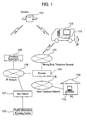
- FIG. 1 is a drawing showing a general configuration of the navigation system.
- the system consists of a satellite 101; a user's vehicle 102; a user's terminal 122; a moving body telephone network 103; a provider 104 performing a connection to the Internet; a broadcast corporation 105 receiving data sent from the satellite, and distributing the received data to users via an IP network 106; a navi-server 107 connected to the IP network 106 used for sending/receiving data that is distributed between the broadcast corporation 105 and provider 104; a fixed telephone network 108 to send/receive data through the IP network 106 or moving body telephone network 103 with being connected to the provider 104; a personal computer 110 at each user's home 109; VICS Center; and Japan Road Traffic Information Center (JARTIC), or a traffic information providing center 100 such as an ATIS that provides traffic information.
- JARTIC Japan Road Traffic Information Center
- the user's vehicle 102 is not always to be a vehicle and may be a person (pedestrian) when the user's terminal 122 is a hand held terminal such as a cellular phone, a PHS, Bluetooth, a wireless LAN, or an ETC terminal, equipped with a wireless communications function.
- a hand held terminal such as a cellular phone, a PHS, Bluetooth, a wireless LAN, or an ETC terminal, equipped with a wireless communications function.
- the navi-server 107 receives a latitude and longitude of a user's terminal in question, a moving speed of the user's terminal, its moving direction, a user ID number, an authentication password, an engine rotation number and other parameters representing vehicle conditions, that are sent from the user's terminal 122 mounted on the user's vehicle 102 through the IP network 106; and data relating to such a request service ID which the user desires.
- the navi-server 107 sends the above sent data to any one of function units of a user control unit 111, a map edit unit 114, a route search unit 116, and a traffic information control unit 112 depending on a service requested by the user.
- CGI common gate interface
- information relating to the service in response to the user's request is sent to the user's terminal 122 of the user's vehicle 102 through the CGI 115, IP network 106, provider 104, and moving body telephone network 103 (hereinafter this route is called “communications network”). Or else when using a broadcast in sending the information relating the service, the information is sent to the user's terminal 122 through the CGI 115, IP network 106, broadcast corporation 105, and satellite 101 (hereinafter this route is called “broadcast network").
- a fixed telephone network is used and the information is sent to the personal computer 110 at each user's home 109 through the CGI 115, IP network 106, provider 104, and fixed telephone network 108.
- the user control unit 111 is equipped with a user information database 118 and a user information registration/edit portion 117. When there exists a request for a user information registration/edit among data sent from a user, the unit 111 registers/edits relevant items checking the user information database 118 based on a relevant user ID
- the map edit unit 114 is configured of a map data base 125 and map cut-out portion 124.
- the unit 114 sends the map data of a predetermined area including the designated place to him/her by reading it with the map cut-out portion 124 from the map data base 125.
- the map edit unit 114 is automatically called, cuts out the relevant area of the map data, and downloads it to a user side.
- the route search unit 116 is configured of an option information database 126, a route search engine 127, an option information setting/changing portion 128, and a guide point making portion 129.
- the option information setting/changing portion 128 sets/changes option information based on information of a departure place (present place) and a destination sent from the user or else a route point, and moreover based on the option information (for example, prevalently utilizing common roads/highways, being able to arrive in shortest time, and the like) if any; and then, the route search engine 127 computes a route from his/her car position to the destination using a route search method such as Dijkstra method.
- the guide point making portion 129 extracts a point indicating an intersection to turn right/left and a point to change a lane on the route obtained by the route search engine 127, reads simple graphics such as an enlarged intersection map and a lane at each extracted point, sound data for a guide, and the like from the option information database 126, thereby making guide point information.
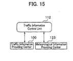
- the traffic information control unit 112 is configured of a traffic information DB 113 (traffic information database), a traffic jam forecast portion 120, and a traffic jam statistical processing portion 121.
- the traffic information control unit 112 stores traffic information such as a traffic amount, a traffic jam, travel time, and accident/regulation information that is periodically sent from the traffic information providing center 100.
- traffic jam information and the like obtained from collected information (probe information) by a probe car may also be stored in the traffic information DB 113.
- the traffic jam statistical processing portion 121 uses the stored traffic information, the traffic jam statistical processing portion 121 computes the occurrence frequency of the traffic jam at an intersection and each road zone, thereby making traffic jam statistical data consisting of a traffic jam frequent occurrence point, its occurrence frequency, and the like.
- the traffic jam forecast portion 120 makes forecast data (hereinafter called "traffic jam forecast data") relating to a traffic jam trend such as whether each traffic jam tends to be in an extending trend or in an extending trend hereafter or else a traffic jam situation does not change. And the traffic information control unit 112 stores the made traffic jam statistical data and traffic jam forecast data in the traffic information DB 113.
- traffic jam forecast data relating to a traffic jam trend such as whether each traffic jam tends to be in an extending trend or in an extending trend hereafter or else a traffic jam situation does not change.
- traffic information control unit 112 stores the made traffic jam statistical data and traffic jam forecast data in the traffic information DB 113.
- the navi-server 107 When a request for downloading traffic information in a vicinity of a designated place such as a present place from a user for the navi-server 107, the navi-server 107 reads real-time traffic information distributed from the traffic information providing center 100, traffic jam forecast data and traffic jam statistical data processed/made at the traffic information control unit 112 from the traffic information DB 113, and sends them to the user in response to his/her request. In addition, when traffic information on a route is requested, the navi-server 107 obtains the route data from the user control unit 111, extracts the traffic information (similar information to that in the vicinity of the designated place) on the route, and sends it to the user.
- a fare calculation unit 119 is a portion where an accounting processing of a service fare for an in-vehicle terminal.
- the unit 119 has a function of an accounting for contents such as map data, route data, and traffic information data and another function of notifying respective in-vehicle terminals of communications fares by counting packets of communications data.
- contents such as map data, route data, and traffic information data
- FIG. 3 a configuration of a car navigation (navi) terminal that is one example of the user's terminal 122 mounted on the user's vehicle 102 is described.
- the navi-terminal is equipped with a display apparatus 130, a GPS receiver 131, a cellular phone 134, a mike 137, and a speaker 138 connected to a main body 132, and the body 132 is equipped with a memory card slot 133.
- the navi-terminal is equipped with a remocon 135 to operate the body 132.
- the display apparatus 130 is a device that can display graphics such as a liquid crystal screen image.
- the GPS receiver 131 is an apparatus to receive a plurality of position measuring signals and to accurately calculate a terminal position.
- the main body 132 is an apparatus where a CPU, a memory, a power source, and a device for a graphics display. The detail will be described later referring to FIG. 4.
- the cellular phone 134 is an apparatus to communicate with outside, that is, to send/receive data to/from the navi-server 107.
- the remocon 135 is an apparatus to transmit operation by a button which a user wants to perform.
- the mike 137 enables a command to be also sent by voice.
- the speaker 138 is a device to perform a voice output such as information received from the navi-server 107, a user assistance in operation of the navi, and a beep in attention/warning.
- the memory card slot 133 is utilized to store received data from the navi-server 107 by connecting an external memory medium represented by a memory card using such as an involatile memory and small size hard disk, and to load information downloaded from the navi-server 107 in the past to the navi-terminal.
- the memory card slot 133 can be used only as a memory apparatus and also be used for a communications interface or an authentification of user information to receive a broadcast. For example, when a vehicle mounting the navi-terminal is a vehicle (and navi terminal) used by an unspecified number of users such as a rent-a-car, the user becomes able to utilize a service by inserting a memory card where authentication information is written into the memory card slot 133.
- the main body 132 may be added as other telecommunications apparatuses: a PHS (Personal Handphone System), Bluetooth, a wireless LAN, or something with a wireless telecommunications function of such a DSRC (Dedicated Short Range Communication) terminal of an ETC and the like; or else broadcast electric waves from a satellite, broadcast electric waves that uses ground wave digital, a receiver that can receive broadcast electric waves using AM/FM electric waves, and an apparatus that decodes received data.
- a position identifying service using the PHS and cellular phone may be used.
- FIG. 3 shows the example of navi-terminals as one example of the user's terminal 122, particularly such the navi main body 132 and display apparatus 130 in the user's terminal 122 can also be substituted by terminals having a certain degree of display means such as a PDA, a note PC, and the cellular phone.
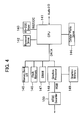
- FIG. 4 is a drawing showing one example of a hard configuration of the main body 132 in navi-terminals.
- the example is configured of a CPU 141, a remocon driver 142 that translates signals from the remocon 135, an RS-232C driver 143, a cellular phone driver 144, a memory card slot 133 and a memory card interface 145, a flash memory 146, a DRAM 147, a graphics processor 148, a graphics memory 149, and an NTS encorder 150.
- An audio input/output is used for an input from a mike 137 for a voice identification, and for a voice guide output to a speaker 138.
- the configuration described above is a configuration in a case where data sending/receiving with the navi-server 107 is performed by communications
- another configuration in a case of using broadcast media needs as described before an interface with an antenna to receive a broadcast, decorder, and the like.
- an NTSC is typically used as signals to the display apparatus 130
- a portion of the NTSC encorder 150 is naturally an encorder corresponding to a PAL system in an area where the PAL system is used for a broadcast or in a case where the display apparatus 130 corresponds to the PAL system.
- a traffic information providing service by the navigation system is described.
- real-time information such as traffic jam/travel time information, accident/regulation information, SA (Service Area)/ PA (Parking Area) information, parking lot information, or various traffic jam information including processed information such as traffic jam forecast information and traffic jam statistical information.
- SA Service Area
- PA Parking Area
- the user's terminal 122 mounted on the vehicle 102 sends the download request of the traffic information to the navi-server 107 through the moving body telephone network 103, provider 104, and IP network 106.
- the terminal 122 sends either designated position information such as a present position described with a latitude/longitude and the like or an area of which map data and traffic information is downloaded, and ID information and an IP address showing a position on the IP network of the navi-server 107.
- the terminal 122 sends these information to the provider 104 through the moving body telephone network 103.
- the provider 104 identifies the IP address of the navi-server 107 designated by the user's terminal 122 from the information sent from it, and accesses the navi-server 107 through the IP network 106.
- the navi-server 107 stores the traffic information sent from the traffic information providing center 100 (a plurality of centers may exist), analyzes traffic jam statistical information such as a traffic jam occurrence frequency of each road zone and intersection, and an average traffic jam degree; and a traffic jam change until then, and thereby makes traffic jam forecast information forecasting an increase/decrease trend of a traffic jam in a near future with a traffic jam statistical processing portion 121 and a traffic jam forecast portion 120, respectively, as needed.
- traffic jam statistical information such as a traffic jam occurrence frequency of each road zone and intersection, and an average traffic jam degree
- the navi-server 107 When the download request of the traffic information is sent from the user's terminal 122, from the traffic information DB 113 the navi-server 107 reads the real-time information such as the traffic jam/travel time information, accident/regulation information, SA (Service Area)/ PA (Parking Area) information, and parking lot information within a data request area, or else the various traffic jam information including the processed information such as the traffic jam forecast information and traffic jam statistical information.
- the navi-server 107 sends the read traffic information to the broadcast corporation 105, the corporation 105 encodes the traffic information, and after packetizing, sends toward the satellite 101.
- the terminal 122 After the user's terminal 122 mounted on the user's vehicle 102 receives data sent from the satellite 101, the terminal 122 outputs traffic information obtained by decoding the data to the display apparatus 130 and speaker 138.
- a next embodiment shows a method to obtain the traffic information by communications only.
- a navi-terminal sends a data request area, designated position information, a user ID, an IP address of the navi-server 107, and the like to the moving body telephone network 103, and sends the above data to the navi-server 107 through the provider 104 and IP network 106.
- the navi-server 107 reads traffic information requested for a download.
- the navi-server 107 sends them to the user's terminal 122 of the vehicle 102 through the IP network 106, provider 104, and moving body telephone network 103. And the user's terminal 122 outputs the received traffic information to the display apparatus 130 and speaker 138.
- information not needed to be frequently updated like the traffic jam statistical information may be stored in a memory medium such as a hard disk and a memory card in advance.
- the information may be updated by overwriting stored data in the memory medium; or else it may be saved as other data.
- the user's terminal 122 reads data in question from the memory medium as needed, thereby becoming able to output traffic information anytime without performing data communications.
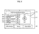
- FIG. 5 is one example of a screen image configuration in the user's terminal 122 where a user selects the traffic information which he/she wants to download.
- a traffic jam information 201 showing a present traffic jam situation
- an accident/regulation information 202 showing information such as no thoroughfare, a lane regulation, and an accident
- a parking lot information 203 showing vacant/full information of parking lots
- a traffic jam forecast information 204 showing whether the traffic jam of each road zone is in an extending trend or a diminishing trend
- a traffic jam statistical information 205 showing statistical information such as a traffic jam occurrence frequency and an average traffic jam degree
- a user selects traffic information which he/she wants to download by operating a voice input through the remocon 135 and mike 137, or else an ON button 210 or an OFF button 21 disposed at a side of each item thorough an operation portion such as hard switches equipped with the navi main body 132
- the traffic information for which the ON button 210 is selected in the screen image is requested for the navi-server 107.
- the screen image is set as shown in FIG. 5, it results in requesting each traffic information relevant to the traffic jam information 201, accident/regulation information 202, traffic jam forecast information 204, and traffic jam statistical information 205 for the navi-server 107.
- FIG. 6 is one example of a transition screen image where a user designates a position on a screen image and downloads traffic information in the periphery of the point.
- the user scrolls (301) a map from a screen image 300 displaying a present position till a point of which traffic information he/she wants, through an operation portion such as a remocon.
- a menu screen image 302 by pushing down a "Menu" button.
- a traffic information button 304 in the menu
- a menu screen image 303 confirming whether he/she downloads traffic information is displayed.
- FIG. 7 is one example of a processing flow in a terminal when downloading traffic information.
- a request position decision of the traffic information decide whether a download area is in a periphery of a present position or in a periphery of a point which a user sets a request position on a screen image (S1000).
- the traffic information in the periphery of the present position obtains the latitude/longitude information of his/her car position by position detection means such as a GPS and a gyro (S1001).
- position detection means such as a GPS and a gyro
- the traffic information in the periphery of the point which he/she designated obtain a selected position on the screen image and convert it to the latitude/longitude information of his/her car position (S1002).
- the terminal 122 when the terminal 122 is set so as to display the traffic information on the display apparatus 130 (S1006), it reads downloaded traffic information from the memory medium and displays stored traffic information overlapped on a map (S1007). Meanwhile, when a route to a destination is set and a route guide screen image for the route (for example, a simple graphic and a schematic map such as a deformation map) is displayed, the user's terminal 122 may display not only the traffic information on the map but also the downloaded traffic information also in the route guide screen image.
- a route guide screen image for the route for example, a simple graphic and a schematic map such as a deformation map
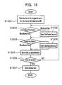
- the unit performs a making processing of the traffic jam statistical information and traffic jam forecast information. Firstly, the making processing of the traffic jam statistical information is described according to a flowchart in FIG. 14.
- the traffic information control unit 112 receives the traffic jam information of each link ID periodically sent from the traffic information providing center 100, and reads the traffic jam information in a designated period (for example, a past month from present and the like) out of the traffic jam information stored for a predetermined period (S1200).
- a designated period for example, a past month from present and the like
- S1200 a predetermined period
- a first abnormal value detection/removal processing assumes that the whole day data relating to a relevant ID link is abnormal (S1201) in link ID data showing a traffic jam over predetermined hours in a day (for example, not less than 20 hours including a night in 24 hours) since special situations are thought such as the trouble of the vehicle sensor and an event (for example, Tokyo Motor Show), and thereby the processing removes (S1202) the whole data of the relevant day not to use it for the making of the traffic jam statistical information.
- a second abnormal value detection/removal processing is performed for remaining data for which the first abnormal value detection/removal processing is performed.
- the second abnormal value detection/removal processing compares between traffic jam information in a same time zone of a plurality of days, assumes that data with a large deviation is abnormal (S1203), and thereby removes (S1204) the data. For example, relating to a road of a certain link ID, when each traffic jam occurrence time per hour from 10 to 11 a.m. in five days of weekdays is 0, 15, 20, and 50 minutes, the processing removes the data of 0 and 50 minutes that are large in difference from the average value (21 minutes), assuming them to be abnormal.
- the unit 112 makes the traffic jam statistical information by averaging remaining data (S1205). Perform the processings of the S1201 to S1205) for all links. And make the traffic jam statistical information of each link a format to distribute to a user's terminal, home PC, and the like, and moreover, perform a distribution format edit such as a division of the data per mesh described later (S1207).
- the information may be designed to be automatically made periodically, for example, once per month using a calendar/clock function of a navi-server; or else to be made by a navi-server operator inputting commands to make the information according to his/her necessity.
- a control segment where a control easiness of traffic information data in the navi-server 107 is taken into consideration, while citing an example.
- the processing controls traffic jam information data to be stored per region called a mesh that divides a land surface at an equal distance with a latitude/longitude, and makes the traffic jam statistical information for each the mesh.
- controls as follows are acceptable: one control by each prefecture; each city, ward, town, village; each block number, and the like; or another control by a road kind such as each high way, national road, prefecture road, and the like; or still another control by a combination of the plurality of the above control lots.
- the traffic jam statistical information per each day of the week or per each weekday/Sunday/holiday by making read traffic jam information per each day of the week.
- a traffic situation is special such as a golden week and Bon holidays, a year end/year start
- it is acceptable to make the above traffic jam statistical information taking into consideration a time zone such as a.m./p.m.
- a rank of a traffic jam occurrence frequency and the like depending on averaged traffic jam information may be classified. For example, classify it into three ranks: a traffic jam rank 1 (smooth) in a case that average traffic jam occurrence time in one hour is 0 to 10minutes; a traffic jam rank 2 (crowded) in a case that the average traffic jam occurrence time in one hour is 10 to 30minutes; and a traffic jam rank 3 (jammed) in a case that average traffic jam occurrence time in one hour is 30 to 60minutes.
- a traffic jam rank 0 no obtaining of traffic jam statistical information
- the example in the flowchart of FIG. 14 shows to make the traffic jam statistical information per link that is a road zone, and next, another example of making the traffic jam statistical information per point such as an intersection is described.
- a processing procedure is similar to the S1200 to S 1206 in the flowchart of FIG. 14, and after the termination of the processing of the S1206, a point edit processing (S1208) like next is added.
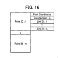
- the S1208 makes the traffic jam statistical information of a point from that of a link, based on a point DB made in advance such as FIG. 16.
- the point DB is made making a link 600 flowing in a point 601 an objective as shown in FIG.
- the S 1208 adopts maximum one out of average traffic jam occurrence time in each link ID by making all links that flow in the point the objective based on the point DB. Or make the traffic jam statistical information by adopting something showing a traffic jam potential as a point such as an average value of the average traffic jam occurrence time in each link ID. And make the traffic jam rank depending on the average traffic jam occurrence time of each point.
- the distribution format edit of the S1207 performs a similar processing to the distribution format edit per link described above.
- the traffic jam statistical information per point can be made. As shown in FIG. 16, since the traffic jam statistical information per point is a consolidated one of the traffic jam statistical information of a link flowing in a relevant point, the information per point can reduce a data amount compared to that of the traffic jam statistical information per link unit and is also effective in improving a viewing identification by evading an untidy display when displayed on a wide area map. Since the information per point concretely means traffic jam information of each intersection, it becomes possible to easily grasp how much crowded/jammed situation each intersection is in.
- the processing stores/analyzes the changes of traffic jam indexes from before predetermined time till present (nearest past), and makes the traffic jam forecast information that is an increase/decrease trend of a traffic jam in a near future. For example, if an analyzed result of the changes of the traffic jam indexes is in an increase direction of the traffic jam, the processing judges that the traffic jam extends hereafter; if the analyzed result is in a decrease direction of the traffic jam, the processing judges that the traffic jam is in a diminishing direction.
- the judgment of the traffic jam trends may judge using traffic jam information only in the nearest past from before predetermined time till present, or may judge using statistically processed traffic jam statistical data such as data average values stored for a predetermined period such as one month in addition to the traffic jam information in the nearest past from before predetermined time till present.
- the traffic jam rank may be classified according to the largeness/smallness of change ratios of the traffic jam indexes in the analyzed result of the traffic jam indexes, and for example, is represented such as: large in a traffic jam increase trend, small in a traffic jam increase trend, large in a traffic jam decrease trend, and small in a traffic jam decrease trend.
- FIG. 8 is one example of a processing flow of the navi-server 107 in downloading the traffic information.
- the unit 112 When the unit 112 receives the request command of the traffic information from a navi-terminal (S1100), the unit 112 analyzes the request command and extracts such a rectangle area where the traffic information should be downloaded out of the request command and a data kind to be downloaded (real-time traffic jam information, accident/regulation information, parking lot information, traffic jam statistical information, and traffic jam forecast information, and the like) (S1101).
- a data kind to be downloaded real-time traffic jam information, accident/regulation information, parking lot information, traffic jam statistical information, and traffic jam forecast information, and the like
- a request area conversion S 1102 searches out a mesh including the rectangle area and performs a processing to set the traffic information of a relevant mesh as a read objective.
- a request data decision S1103 decides a requested data kind and branches the data read processings (S1104-S1108) of the relevant data kind, and if the requested data kind is traffic jam statistics, traffic jam statistical data is read; if the requested data kind is real-time traffic jam information, the real-time traffic jam data is read; if the requested data kind is an accident/regulation, the accident/regulation information data is read; if the requested data kind is traffic jam forecast information, the traffic jam forecast information data is read; and if the requested data kind is a parking lot, the parking lot data is read.
- a read termination decision S1109 decides whether or not the reading of all requested kinds of traffic information is terminated.
- the decision S1109 updates the data kinds to be downloaded and transits to the request data decision S1103.
- all the traffic information is read, it is converted to a communications format type where header information such as each information kind and data size is added to the traffic information read with a format conversion S 1110.
- a sending processing S1111 sends the traffic information already converted to the communications format type to the user's terminal 122 and home PC 110 through the CGI 115, IP network 106, and the like.
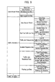
- FIG. 9 is one example of a communications format relating to traffic information.
- a control header portion is traffic information control data configured of a total data size of communications data, a data number representing a sheet of mesh of an objective region included in the communications data, an offset from top data to data per each mesh, the data size described before, and the like.
- the traffic information controlled per each mesh is configured of the data header portion and a data portion of data kinds requested for a download such as real-time traffic jam information data, traffic jam forecast data, accident/regulation data, traffic jam statistical data, parking lot data, and the like.
- the data header portion is composed of control data consisting of a mesh ID that is a unique value added to each region where a land surface is divided at an equal distance with a latitude/longitude coordinate system, a storage data kind representing a data kind stored in the data, an offset of each data kind to a top data, a storage data number, a data size, and the like.
- control data consisting of a mesh ID that is a unique value added to each region where a land surface is divided at an equal distance with a latitude/longitude coordinate system
- a storage data kind representing a data kind stored in the data
- an offset of each data kind to a top data a storage data number, a data size, and the like.
- one traffic jam information is composed of a link ID that is a unique value_within the mesh and is added per road zone, traffic information consisting of such a traffic jam degree and traffic jam length of a road zone for the link ID, and a road shape of a latitude/longitude for the link ID, and these are stored
- the traffic jam forecast data is composed of a link ID, and traffic jam trend information representing whether a traffic jam is in an extending trend or in a diminishing trend, and these are stored by a data number described in the control portion.
- the accident/regulation data is composed of point coordinates of a latitude/longitude representing a place where an accident/regulation has occurred, an ID link representing a road zone where the accident/regulation has occurred, a kind of the accident/regulation such as a lane regulation and no thoroughfare, and an accident/regulation kind representing its causes, and these are stored by a data number described in the control portion.
- the traffic jam statistical data is composed of point coordinates of a latitude/longitude representing a place where a traffic jam frequently occurs or an ID link representing a road zone where the traffic jam frequently occurs, and information such as a statistical time zone representing such a season, month, day of the week, a.m./p.m., and a time zone when the traffic jam frequent occurrence point is effective; a traffic jam occurrence frequency representing the occurrence frequency of the traffic jam (or traffic jam rank); an average traffic jam degree representing an average traffic jam degree in a case of an occurrence of the traffic jam; and a data reliability, and these are stored by a data number described in the control portion.
- the parking lot data is composed of such a parking lot situation consisting of information such as the point coordinates of a latitude/longitude showing the place of a parking lot, a parking lot ID that is an identification code of the parking lot, a full/vacant situation and operation situation (open or closed) of the parking lot, and these are stored by a data number described in the control portion.
- FIGS. 10A and 10B show the display examples of the traffic jam statistical information in such a user's vehicle terminal and home PC.
- FIG. 10A shows that a circular graphic 400 representing a traffic jam frequent occurrence point and its degree is shown overlapped on a map by a circle with a radius depending on a traffic jam occurrence frequency, centering on the traffic jam frequent occurrence point.
- An effective time 401 displayed on an upper left of a screen image shows a date and hour and a time zone when the traffic jam statistical information shown overlapped on the map is effective.
- a data making time and effective date 404 shown on a lower left of the screen image displays a date and hour when the traffic jam statistical information is made, and a date when the traffic jam statistical information is effective.
- the traffic jam statistical information displayed overlapped on the map with the effective time 401 is statistical information between 9 a.m. and 10 a.m. on a weekday of January, and shows its high effectiveness in the time zone.
- the data making and effective data 404 shows that the data is made in June 2002 and is effective till June 2003.
- the embodiment changes a display pattern of a traffic jam statistical information 400.
- a display pattern of a traffic jam statistical information 400 For example, when the map is displayed enlarged (in detail) as in FIG. 10A, a grasp of the traffic jam degree is helped by changing the size of the circle according to the traffic jam occurrence frequency; when the map is displayed diminished (in a wide area) as in FIG. 10B, an identification of a traffic jam occurrence point is helped by displaying a traffic jam occurrence frequency 410 with a predetermined constant size of a circle.
- a traffic jam degree that becomes an objective to be displayed may be changed according to a map scale, and in this case, the traffic jam degree that becomes a reference for each scale of a map, and a circle size in being displayed are defined. Moreover, information concerning whether the circle size is variable or fixed is defined by each scale of the map. By displaying a circle representing the traffic jam degree of an intersection on the map using these information, the traffic jam situation of the intersection can be represented without damaging the viewing identification of the map.
- the traffic jam degree to be displayed is selected by being parallelized with the intersection according to a largeness/smallness of the traffic jam degree, it is acceptable to select it based on a reliability of a traffic jam situation described later.
- a reliability of a traffic jam situation described later by displaying a traffic jam situation on a map with restricting traffic information with over a constant value of a reliability, it is possible to grasp an outline with a high reliability relating to the traffic jam situation when displaying the map being diminished.
- the circle size may be determined according to an average traffic jam degree in a point in question. Or else a display changed depending on information (occurrence frequency or average traffic jam degree) relating to the traffic jam situation may be a circle color instead of the circle size, and their combination.
- a circumference portion of a displayed circle may be displayed in a solid line or a broken line.
- a solid line 400 signifies that the data reliability is comparatively high
- a broken line 406 signifies that the data reliability is comparatively low.
- the data reliability corresponds to a repeatability of the traffic jam statistical information, and when the repeatability is high and a probability that the repeatability largely changes depending on a day is small, the reliability becomes high.
- the reliability is determined by a variance (or standard deviation) of values such as traffic jam occurrence time in each day, an average traffic jam rank, or travel time. For example, for a road with a certain link ID, when each traffic jam occurrence time per hour from 10 a.m. to 11 a.m. for five days of weekdays is 0, 15, 20, 20, and 50 minutes, their standard deviation is 18.1659 minutes. By comparing it with a threshold, a plurality of classifications can be possible for the reliability.
- thresholds may be as follows: a standard deviation 0 to less than 10 minutes, a rank 1 (high reliability); a standard deviation 10 to less than 20 minutes, a rank 2 (middle reliability); a standard deviation not less than 20 minutes, a rank 3 (low reliability); and the like.
- a kind of line may be changed as a dotted line, a broken line, a dashed line, a chain double-dashed line, and the like depending on the reliability.
- the terminal may automatically select and display most effective traffic jam statistical information for such a present time zone by using a calendar which a terminal has, time data that is received from a GPS, and time data which a vehicle controls; or a user may display the traffic jam statistical information of a time zone different from such the present time zone depending on his/her preference by providing a means manually operating the effective time 401 of the traffic jam information.
- the embodiment displays the data making time and effective date 404 of the traffic jam statistical information with a character string
- the traffic jam statistical information data is within the effective date
- the data is out of the effective date
- display the plate color of the effective time 401 in red when the traffic jam statistical information data is within the effective date
- the plate color of the effective time 401 in grey
- the data is out of the effective date
- the traffic jam statistical information data when the traffic jam statistical information data is within the effective date, display the traffic jam frequent occurrence point as described before; when a present date and hour passes an effective date, display the traffic jam frequent occurrence point so that the user knows that there exists a problem in a quality of information by changing/displaying a transmisivity, brightness, and tint of a graphic showing the traffic jam frequent occurrence point; making a graphic size small showing the traffic jam frequent occurrence point; and the like.
- one area where the information is provided and the other area where the information is not provided may be displayed in different map-background colors. For example, draw one area where there exists no traffic jam statistical information, in a usual map-background color; and the other area where there exists the traffic jam statistical information, in a different color from the usual map-background color.
- FIGS. 11A to 11D show other display examples of the traffic jam statistical information in a user's terminal and home PC.
- FIG. 11A matches the coordinates of a traffic jam frequent occurrence point at the center position of an image, selects an icon 402 according to a traffic jam occurrence frequency and the like, and thereby displays the traffic jam frequent occurrence point.
- FIG. 11B is an example displaying the traffic jam statistical information not in a point type of such an intersection but per zone (link). It is an example displaying a traffic jam zone in so called a cushion in a traffic jam frequent occurrence zone by drawing a bolder line on a back face of a road shape
- draw background data such as sea, a river, and a green land
- a traffic jam zone 403 is drawn in red
- a traffic jam zone 406 in yellow
- a traffic jam zone 408 in orange.
- drawing information such as roads and names being overlapped
- a screen image like FIG. 11B is displayed. Meanwhile, when displaying a detailed map in combination with the display method of the traffic jam statistical information shown in FIGS.
- a display pattern per link is especially effective in taking a general view of a traffic jam situation of a wide area road network since the display pattern per point corresponds to the traffic jam statistical information where a plurality of links are consolidated as shown in FIG. 16; the display pattern per link is especially effective in grasping a detailed traffic jam situation since the display pattern per link is detailed traffic jam statistical information classified according to proceeding directions. Accordingly, the display patterns may be automatically changed depending on a display scale of a map.
- FIG. 11D shows an example where each traffic jam statistical information of numbers 400, 406, 407, and 408 is displayed overlapped on a map where the numbers 400 and 406 are a per-intersection (point) and the numbers 407 and 408 are a per-zone (link) with a direction.
- a color, length, line boldness, and the like may be classified depending on a traffic jam degree such as a traffic jam occurrence frequency.
- the displays may be changed depending on highness/lowness of the above data reliability.
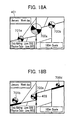
- FIGS. 18A and 18B show still other display examples of the traffic jam statistical information in a user's terminal and home PC.
- FIG. 18A displays circular graphs 700 and 701 representing a traffic jam frequent occurrence point and its traffic jam occurrence frequency, or an average traffic jam degree and an occurrence time zone overlapped on maps by circles with radii depending on the traffic jam occurrence frequency, average traffic jam degree, and the like, centering on the traffic jam frequent occurrence point (intersection). Since there exist circular graphs representing occurrence time zones, there exists no description of a time zone as for an effective time 401 of the traffic jam statistical information.
- a true north (true up) direction signifies 0 a.m.
- time zones relating to the traffic jam statistical information of 24 hours are clockwise inscribed per hour, and the traffic jam occurrence frequency of a corresponding time zone and the like are represented by colors of graphs.
- an alpha numeral 700a of FIG. 18A signifies that: 0 to 6 o'clock (before 7 o'clock) is smooth; till 9 o'clock (before 10 o'clock), traffic jammed; till 16 o'clock (before17 o'clock), crowded; till 20 o'clock (before 21 o'clock), traffic jammed; till 23 o'clock (before 24 o'clock), smooth.
- FIG. 18B shows the positions of traffic jam frequent road zones (links), and moreover, shows circular graphs representing traffic jam degrees and occurrence time zones relating to each traffic jam frequent road zone overlapped in vicinities of relevant links on a map. Since a display pattern such as the former display pattern per point corresponds to the consolidated traffic jam statistical information of a plurality of links as shown in FIG. 16, it is especially effective in taking a general view of the traffic jam situation of the wide area road network; another display pattern such as the latter display pattern per link is the detailed traffic jam statistical information classified by each proceeding direction, it is especially effective in grasping the detailed traffic jam situation. Accordingly, the display patterns may be automatically changed depending on a display scale of a map. Meanwhile, in the drawings the circumference of the circular graph 700 is a solid line, whereas that of the circular graph 701 is a broken line. As already described, this represents the reliability of the traffic jam statistical information.
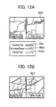
- FIGS. 12A and 12 B show the display examples of the traffic jam forecast information in a user's terminal and home PC.
- FIG. 12 A is an example of a case where a present traffic jam and a traffic jam trend are displayed in a hemmed arrow mark line 500.
- a length of the arrow mark line represents a traffic jam zone
- a color inside the arrow mark line represents a traffic jam degree
- a hemmed color of the arrow mark line represents a traffic jam trend. For example, depict a color inside the arrow mark line in green in case of smooth, in yellow in case of crowded, and in red in case of traffic jam.
- an arrow mark line 504 showing the diminishing trend of a traffic jam zone is drawn hemmed in blue; another arrow mark line 505 showing no increase/decrease trend of another traffic jam zone is drawn hemmed in white; and still another arrow mark line 506 showing the extending trend of still another traffic jam zone is drawn hemmed in violet.
- the embodiment selects whether or not to display the traffic jam forecast information according to the display scale of the map.
- the arrow mark line 500 showing the traffic jam forecast information is displayed together with the traffic jam information;
- a map is displayed in diminution (wide area) as shown in FIG.12B, an arrow mark line 501 showing the traffic jam information is displayed overlapped on the map.
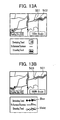
- FIG. 13A is an example of a case showing a present traffic jam situation and a traffic jam trend by an arrow mark line 501 and an icon 502.
- a length of the arrow mark line 501 represents a present traffic jam zone
- a color of the arrow mark line 501 represents a traffic jam degree
- the icon 502 representing a traffic jam trend is displayed overlapped on the arrow mark line 501.
- the embodiment displays the icon 502 at an intermediate point of the traffic jam zone, the icon 502 may be displayed at the end of the traffic jam.
- the icon 502 may be displayed at a plurality of places depending on a distance when the distance of a traffic jam zone is long and the like.
- a length of an arrow mark line 501 represents the present traffic jam zone
- a color of the arrow mark line 501 represents the traffic jam degree
- another line pattern representing the traffic jam trend or a line 503 displaying icons at an equal distance is displayed.
- violet circles 503 are displayed on the yellow arrow mark line 501 at an equal distance from the top of a traffic jam for data where a present crowded road is in the extending trend. Accordingly, blue circles are drawn side by side on an arrow mark line 507 where a traffic jam zone shows the diminishing trend; violet circles are drawn side by side on an arrow mark line 508 where a traffic jam zone shows the extending trend.
- the traffic jam trend with a line width of the arrow mark line 501 and with a line style.
- the followings are acceptable: to draw an arrow mark line with a bolder line than usual, when the traffic jam trend is in the extending trend; to draw an arrow mark line with a thinner line than usual, when the traffic jam trend is in the diminishing trend; to draw an arrow mark line with a double line, when the traffic jam trend is in the extending trend; and to draw an arrow mark line with a broken line, when the traffic jam trend is in the diminishing trend.
- a solid line and a broken line may be used as needed, depending on a reliability relating to the traffic jam forecast information.
- the maps of FIGS. 10A and 10B and the like may be a type of map that displays a periphery of a present point in enlargement (detail) and far from the present point in diminution (wide area), that is, a map displayed like a bird view and a map three-dimensionally displayed.
- a user can easily grasp an intersection and road zone that are routinely and chronically jammed by displaying statistical traffic jam information on a map.
- he/she can also grasp a traffic jam frequent occurrence point and an average traffic jam degree in more detail by being provided with the traffic jam statistical information with respect to each season, weather, and road surface condition, or each Sunday/holiday/weekday and time zone.
- the user can make a judgment reference showing what extent he/she can rely on provided information by the reliability of the traffic jam statistical information being added.
- traffic jam increase/decrease trend information in the server whether a present traffic jam extends or diminishes hereafter and providing the information with the user, it becomes possible for him/her to easily judge whether or not to evade the traffic jam.
- to display the statistical traffic jam information on a map enables a user to easily grasp an intersection and road zone that are routinely and chronically jammed.
Landscapes
- Engineering & Computer Science (AREA)
- Radar, Positioning & Navigation (AREA)
- Remote Sensing (AREA)
- General Physics & Mathematics (AREA)
- Physics & Mathematics (AREA)
- Automation & Control Theory (AREA)
- Biodiversity & Conservation Biology (AREA)
- Environmental Sciences (AREA)
- Environmental & Geological Engineering (AREA)
- Ecology (AREA)
- Life Sciences & Earth Sciences (AREA)
- Atmospheric Sciences (AREA)
- Navigation (AREA)
- Traffic Control Systems (AREA)
- Instructional Devices (AREA)
Applications Claiming Priority (2)
| Application Number | Priority Date | Filing Date | Title |
|---|---|---|---|
| JP2003003832 | 2003-01-10 | ||
| JP2003003832 | 2003-01-10 |
Publications (2)
| Publication Number | Publication Date |
|---|---|
| EP1437573A2 true EP1437573A2 (fr) | 2004-07-14 |
| EP1437573A3 EP1437573A3 (fr) | 2009-07-29 |
Family
ID=32501235
Family Applications (1)
| Application Number | Title | Priority Date | Filing Date |
|---|---|---|---|
| EP04000436A Withdrawn EP1437573A3 (fr) | 2003-01-10 | 2004-01-12 | Procédé d'affichage d'un serveur de navigation et navigation |
Country Status (4)
| Country | Link |
|---|---|
| US (1) | US7983837B2 (fr) |
| EP (1) | EP1437573A3 (fr) |
| KR (1) | KR20040064634A (fr) |
| CN (1) | CN100376870C (fr) |
Cited By (12)
| Publication number | Priority date | Publication date | Assignee | Title |
|---|---|---|---|---|
| NL1027284C2 (nl) * | 2004-10-18 | 2006-04-19 | Goudappel Coffeng B V | Inrichting voor het analyseren van verkeersstromen. |
| EP2133850A1 (fr) | 2005-05-18 | 2009-12-16 | Lg Electronics Inc. | Fourniture d'informations de trafic relatives à une tendance de congestion |
| US7729335B2 (en) | 2005-05-18 | 2010-06-01 | Lg Electronics Inc. | Providing traffic information relating to a prediction of congestion status and using the same |
| EP2313740A1 (fr) * | 2008-06-25 | 2011-04-27 | TomTom International B.V. | Dispositif et procédé de navigation |
| EP2453209A1 (fr) * | 2008-01-06 | 2012-05-16 | Apple Inc. | Interface utilisateur graphique permettant de présenter des informations de localisation |
| CN102564429A (zh) * | 2011-12-28 | 2012-07-11 | 深圳市凯立德科技股份有限公司 | 一种交通信息导航方法及装置 |
| US9310206B2 (en) | 2007-06-28 | 2016-04-12 | Apple Inc. | Location based tracking |
| EP2990764A4 (fr) * | 2013-07-29 | 2016-06-15 | Aisin Aw Co | Système, dispositif, procédé et programme informatique de notification d'informations de trafic |
| US9414198B2 (en) | 2007-06-28 | 2016-08-09 | Apple Inc. | Location-aware mobile device |
| US9620007B2 (en) | 2011-02-03 | 2017-04-11 | Tomtom Traffic B.V. | Method of generating expected average speeds of travel |
| US9702709B2 (en) | 2007-06-28 | 2017-07-11 | Apple Inc. | Disfavored route progressions or locations |
| US9702721B2 (en) | 2008-05-12 | 2017-07-11 | Apple Inc. | Map service with network-based query for search |
Families Citing this family (81)
| Publication number | Priority date | Publication date | Assignee | Title |
|---|---|---|---|---|
| US7415243B2 (en) | 2003-03-27 | 2008-08-19 | Honda Giken Kogyo Kabushiki Kaisha | System, method and computer program product for receiving data from a satellite radio network |
| JP2005049138A (ja) * | 2003-07-30 | 2005-02-24 | Pioneer Electronic Corp | 交通状況報知装置、そのシステム、その方法、そのプログラム、および、そのプログラムを記録した記録媒体 |
| JP2005134429A (ja) * | 2003-10-28 | 2005-05-26 | Pioneer Electronic Corp | 交通状況報知装置、そのシステム、その方法、そのプログラム、および、そのプログラムを記録した記録媒体 |
| US7818380B2 (en) * | 2003-12-15 | 2010-10-19 | Honda Motor Co., Ltd. | Method and system for broadcasting safety messages to a vehicle |
| US8452526B2 (en) * | 2003-12-15 | 2013-05-28 | Gary Ignatin | Estimation of roadway travel information based on historical travel data |
| US8041779B2 (en) * | 2003-12-15 | 2011-10-18 | Honda Motor Co., Ltd. | Method and system for facilitating the exchange of information between a vehicle and a remote location |
| JP2005201793A (ja) * | 2004-01-16 | 2005-07-28 | Xanavi Informatics Corp | ナビゲーション装置の経路探索方法 |
| US7319931B2 (en) * | 2004-04-06 | 2008-01-15 | Honda Motor Co., Ltd. | Methods for filtering and providing traffic information |
| US7366606B2 (en) * | 2004-04-06 | 2008-04-29 | Honda Motor Co., Ltd. | Method for refining traffic flow data |
| US7222018B2 (en) | 2004-04-06 | 2007-05-22 | Honda Motor Co., Ltd. | Bandwidth and memory conserving methods for a vehicle navigation system |
| US7680594B2 (en) * | 2004-04-06 | 2010-03-16 | Honda Motor Co., Ltd. | Display method and system for a vehicle navigation system |
| WO2005099379A2 (fr) | 2004-04-06 | 2005-10-27 | Honda Motor Co., Ltd. | Procede et systeme pour controler l'echange des messages concernant des vehicules |
| US7671764B2 (en) * | 2004-04-06 | 2010-03-02 | Honda Motor Co., Ltd. | Method and system for using traffic flow data to navigate a vehicle to a destination |
| US7680596B2 (en) * | 2004-04-06 | 2010-03-16 | Honda Motor Co., Ltd. | Route calculation method for a vehicle navigation system |
| US7289904B2 (en) | 2004-04-06 | 2007-10-30 | Honda Motor Co., Ltd. | Vehicle navigation system and methods for incorporating user preferences into same |
| JP4627407B2 (ja) * | 2004-04-19 | 2011-02-09 | パイオニア株式会社 | 情報配信システム |
| JP3842799B2 (ja) * | 2004-06-15 | 2006-11-08 | 株式会社ザナヴィ・インフォマティクス | 地図データ提供装置 |
| US7518530B2 (en) * | 2004-07-19 | 2009-04-14 | Honda Motor Co., Ltd. | Method and system for broadcasting audio and visual display messages to a vehicle |
| JP4211706B2 (ja) * | 2004-07-28 | 2009-01-21 | 株式会社日立製作所 | 交通情報提供装置 |
| US7739029B2 (en) * | 2004-09-08 | 2010-06-15 | Aisin Aw Co., Ltd. | Navigation apparatus and method with traffic ranking and display |
| US7643788B2 (en) * | 2004-09-22 | 2010-01-05 | Honda Motor Co., Ltd. | Method and system for broadcasting data messages to a vehicle |
| GB0423793D0 (en) * | 2004-10-27 | 2004-12-01 | Ibm | A method and system for gathering and processing data for road use charging |
| JP4255028B2 (ja) * | 2005-01-31 | 2009-04-15 | 株式会社ザナヴィ・インフォマティクス | ナビゲーション装置、サーバ装置の交通情報送信方法 |
| JP4486520B2 (ja) * | 2005-02-03 | 2010-06-23 | クラリオン株式会社 | ナビゲーション装置 |
| TWI258719B (en) * | 2005-05-02 | 2006-07-21 | Mitac Int Corp | Driving route planning system and method |
| KR20060125449A (ko) * | 2005-06-01 | 2006-12-06 | 엘지전자 주식회사 | 교통 정보를 제공하고 이를 이용하는 방법 및 장치 |
| DE102005039807B4 (de) * | 2005-08-22 | 2013-08-01 | Astrium Gmbh | Bereitstellung von Informationen in Satellitennavigationssystemen |
| US7949330B2 (en) * | 2005-08-25 | 2011-05-24 | Honda Motor Co., Ltd. | System and method for providing weather warnings and alerts |
| US8046162B2 (en) * | 2005-11-04 | 2011-10-25 | Honda Motor Co., Ltd. | Data broadcast method for traffic information |
| US20070130045A1 (en) * | 2005-12-06 | 2007-06-07 | Auction Answers, Llc | Method and apparatus for tracking the progress of an auction |
| US9175977B2 (en) * | 2005-12-20 | 2015-11-03 | General Motors Llc | Method for arbitrating between multiple vehicle navigation systems |
| US8014936B2 (en) * | 2006-03-03 | 2011-09-06 | Inrix, Inc. | Filtering road traffic condition data obtained from mobile data sources |
| US7912628B2 (en) | 2006-03-03 | 2011-03-22 | Inrix, Inc. | Determining road traffic conditions using data from multiple data sources |
| US20070239352A1 (en) * | 2006-04-10 | 2007-10-11 | Microsoft Corporation | Embedded dynamic map generation |
| JP4177394B2 (ja) * | 2006-08-16 | 2008-11-05 | 本田技研工業株式会社 | ナビ装置、ナビサーバおよびナビシステム |
| KR100822011B1 (ko) * | 2006-12-21 | 2008-04-15 | 에스케이에너지 주식회사 | 네비게이션 단말기, 그의 교통정보 안내방법, 교통정보제공 시스템 및 방법 |
| US9157760B2 (en) * | 2007-01-12 | 2015-10-13 | Aol Inc. | Community mapping and direction indicating |
| JP4891792B2 (ja) * | 2007-01-26 | 2012-03-07 | クラリオン株式会社 | 交通情報配信方法および交通情報配信装置 |
| JP2008209208A (ja) * | 2007-02-26 | 2008-09-11 | Denso Corp | カーナビゲーション装置 |
| US20080262710A1 (en) * | 2007-04-23 | 2008-10-23 | Jing Li | Method and system for a traffic management system based on multiple classes |
| US7668653B2 (en) | 2007-05-31 | 2010-02-23 | Honda Motor Co., Ltd. | System and method for selectively filtering and providing event program information |
| US8099308B2 (en) * | 2007-10-02 | 2012-01-17 | Honda Motor Co., Ltd. | Method and system for vehicle service appointments based on diagnostic trouble codes |
| US20090106036A1 (en) * | 2007-10-22 | 2009-04-23 | Kazuya Tamura | Method and system for making automated appointments |
| US20090265091A1 (en) * | 2008-04-16 | 2009-10-22 | Xanavi Informatics Corporation | Method and apparatus utilizing both statistical and real time data for a vehicle navigation system |
| WO2009132676A1 (fr) | 2008-05-02 | 2009-11-05 | Tom Tom International B.V. | Dispositif et procédé de navigation pour souligner un itinéraire sur une carte |
| US9200908B2 (en) * | 2008-07-17 | 2015-12-01 | Volkswagen Ag | Navigation system for a motor vehicle |
| US9202375B2 (en) * | 2008-07-17 | 2015-12-01 | Volkswagen Ag | Navigation system for a motor vehicle |
| US8135804B2 (en) * | 2009-07-07 | 2012-03-13 | Honda Motor Co., Ltd. | Method for scheduling and rescheduling vehicle service appointments |
| TWI409435B (zh) * | 2009-10-09 | 2013-09-21 | Mitac Int Corp | 導航系統與導航方法 |
| CN102243809B (zh) * | 2010-05-12 | 2016-04-20 | 高德软件有限公司 | 一种展现实时交通信息的方法和装置 |
| CN101872362B (zh) * | 2010-06-25 | 2016-05-04 | 大陆汽车投资(上海)有限公司 | 动态语音标签信息查询系统及其信息查询方法 |
| US8521424B2 (en) * | 2010-09-29 | 2013-08-27 | Ford Global Technologies, Llc | Advanced map information delivery, processing and updating |
| JP5790224B2 (ja) * | 2011-07-13 | 2015-10-07 | アイシン・エィ・ダブリュ株式会社 | 地図表示システム、方法およびプログラム |
| US20140207357A1 (en) * | 2011-11-10 | 2014-07-24 | Mitsubishi Electric Corporation | Vehicle-side system |
| JP5803645B2 (ja) * | 2011-12-15 | 2015-11-04 | アイシン・エィ・ダブリュ株式会社 | 評価表示システム、方法およびプログラム |
| JP5456818B2 (ja) * | 2012-03-27 | 2014-04-02 | 本田技研工業株式会社 | ナビサーバ、ナビクライアント及びナビシステム |
| KR101438651B1 (ko) * | 2012-04-03 | 2014-09-12 | 주식회사 나우드림 | 기상재해정보 기반의 경로 안내 정보 및 부가정보를 제공하는 방법 및 시스템 |
| CN103546521B (zh) * | 2012-07-17 | 2017-09-22 | 上海遥薇(集团)有限公司 | 一种车路协同卫星定位信息化系统 |
| CN102879000A (zh) * | 2012-09-20 | 2013-01-16 | 华为终端有限公司 | 导航终端、导航方法及远程导航服务系统 |
| CN102865876A (zh) * | 2012-09-25 | 2013-01-09 | 深圳华宏联创科技有限公司 | 导航方法和服务器及系统 |
| CN102938215B (zh) * | 2012-10-24 | 2015-09-23 | 安科智慧城市技术(中国)有限公司 | 一种指挥处警方法和系统 |
| CN103888915A (zh) * | 2012-12-24 | 2014-06-25 | 腾讯科技(武汉)有限公司 | 一种气象信息更新方法及服务器 |
| US9053636B2 (en) * | 2012-12-30 | 2015-06-09 | Robert Gordon | Management center module for advanced lane management assist for automated vehicles and conventionally driven vehicles |
| US9286800B2 (en) * | 2012-12-30 | 2016-03-15 | Robert Gordon | Guidance assist vehicle module |
| CN104050829A (zh) * | 2013-03-14 | 2014-09-17 | 联想(北京)有限公司 | 一种信息处理的方法及装置 |
| JP6119387B2 (ja) * | 2013-04-09 | 2017-04-26 | 株式会社デンソー | ナビゲーションシステム、ナビゲーション装置、および、データ配信サーバ |
| US11481091B2 (en) * | 2013-05-15 | 2022-10-25 | Google Llc | Method and apparatus for supporting user interactions with non- designated locations on a digital map |
| US9251610B2 (en) | 2013-05-29 | 2016-02-02 | Globalfoundries Inc. | Location info-graphics visualizations |
| JP6049551B2 (ja) * | 2013-06-21 | 2016-12-21 | 三菱電機株式会社 | ナビゲーション装置 |
| CN104282165B (zh) * | 2013-07-12 | 2017-07-28 | 深圳市赛格导航科技股份有限公司 | 路段拥堵预警方法及装置 |
| WO2015042171A1 (fr) * | 2013-09-18 | 2015-03-26 | Jolata, Inc. | Identification hautement probable de messages associés utilisant des ensembles de fonctions de hachage clairsemées |
| US9300417B2 (en) * | 2014-01-06 | 2016-03-29 | GM Global Technology Operations LLC | Methods and apparatus for providing user-selectable preset options and associated data for a vehicle onboard computer system |
| CN105387865B (zh) * | 2015-10-16 | 2020-07-03 | 上海博泰悦臻网络技术服务有限公司 | 一种基于交通道路数据的路径规划方法及系统 |
| US10109185B1 (en) * | 2016-07-25 | 2018-10-23 | 360fly, Inc. | Method and apparatus for traffic monitoring based on traffic images |
| CN107967812A (zh) * | 2016-10-19 | 2018-04-27 | 高德信息技术有限公司 | 一种导航路线交通状态的确定方法及装置 |
| WO2018223284A1 (fr) * | 2017-06-06 | 2018-12-13 | 深圳市乃斯网络科技有限公司 | Procédé et système d'attribution intelligente de point de violation de règle de véhicule de circulation |
| CN108153827B (zh) * | 2017-12-11 | 2022-02-22 | 北京小米移动软件有限公司 | 交通拥堵区域确定方法及装置 |
| CN111238525A (zh) * | 2018-11-29 | 2020-06-05 | 沈阳美行科技有限公司 | 一种基于车道的交通流量信息显示方法、装置及相关设备 |
| CN116524707A (zh) * | 2022-01-20 | 2023-08-01 | 博泰车联网(南京)有限公司 | 交通拥堵的预测方法、电子设备及存储介质 |
| CN115841752A (zh) * | 2022-11-28 | 2023-03-24 | 北京红山信息科技研究院有限公司 | 一种出行堵塞改良系统 |
| CN118746306B (zh) * | 2024-06-11 | 2025-03-18 | 三峡金沙江川云水电开发有限公司 | 一种综合巡检路径智能规划方法、系统及储存介质 |
Citations (7)
| Publication number | Priority date | Publication date | Assignee | Title |
|---|---|---|---|---|
| US5539645A (en) | 1993-11-19 | 1996-07-23 | Philips Electronics North America Corporation | Traffic monitoring system with reduced communications requirements |
| US5739773A (en) | 1995-11-17 | 1998-04-14 | Matsushita Electric Industrial Co., Ltd. | Vehicular navigation apparatus enabling easy recognition of displayed traffic information |
| WO1999048073A1 (fr) | 1998-03-19 | 1999-09-23 | Mannesmann Vdo Ag | Systeme de navigation traitant des evenements de la circulation |
| US6178374B1 (en) | 1996-10-10 | 2001-01-23 | Mannesmann Ag | Method and device for transmitting data on traffic assessment |
| US6259377B1 (en) | 1997-05-24 | 2001-07-10 | Daimlerchrysler Ag | Process for detecting and reporting traffic situation data |
| US20020030611A1 (en) | 2000-08-22 | 2002-03-14 | Rene Nuesser | Method for transmitting data packets between motor vehicles |
| US20020120389A1 (en) * | 2001-02-23 | 2002-08-29 | Hitachi, Ltd. | Method of presuming traffic conditions by using floating car data and system for presuming and presenting traffic conditions by using floating data |
Family Cites Families (21)
| Publication number | Priority date | Publication date | Assignee | Title |
|---|---|---|---|---|
| US5293163A (en) * | 1990-06-06 | 1994-03-08 | Mazda Motor Corporation | Navigation apparatus for vehicles |
| US5164904A (en) | 1990-07-26 | 1992-11-17 | Farradyne Systems, Inc. | In-vehicle traffic congestion information system |
| JPH04174894A (ja) | 1990-11-08 | 1992-06-23 | Nec Corp | 道路渋滞情報表示装置 |
| JPH06348997A (ja) * | 1993-06-04 | 1994-12-22 | Sumitomo Electric Ind Ltd | ナビゲーション装置 |
| JP3472896B2 (ja) | 1994-12-28 | 2003-12-02 | オムロン株式会社 | 交通情報システム |
| JPH08221687A (ja) | 1995-02-20 | 1996-08-30 | Nec Home Electron Ltd | 道路渋滞認識方法及びナビゲーション装置 |
| US5874905A (en) * | 1995-08-25 | 1999-02-23 | Aisin Aw Co., Ltd. | Navigation system for vehicles |
| JPH09113290A (ja) | 1995-10-18 | 1997-05-02 | Sumitomo Electric Ind Ltd | 道路地図表示装置 |
| JPH09180094A (ja) | 1995-12-22 | 1997-07-11 | Matsushita Electric Ind Co Ltd | 航法装置と情報提供システム |
| JP4108150B2 (ja) | 1996-09-03 | 2008-06-25 | 富士通テン株式会社 | 道路情報送信装置及び道路情報表示装置 |
| EP0863381B1 (fr) * | 1997-03-07 | 2004-06-02 | Pioneer Electronic Corporation | Dispositif de navigation |
| JP3734594B2 (ja) * | 1997-05-16 | 2006-01-11 | 三菱電機株式会社 | 異常事象検出装置および交通流計測装置 |
| JPH11281378A (ja) | 1998-03-26 | 1999-10-15 | Sanyo Electric Co Ltd | ナビゲーション装置 |
| JP2000235562A (ja) | 1999-02-16 | 2000-08-29 | Nippon Telegr & Teleph Corp <Ntt> | 非数値化要因の数量化方法、装置、および非数値化要因数量化プログラムを記録した記録媒体 |
| JP3399401B2 (ja) | 1999-04-16 | 2003-04-21 | 住友電気工業株式会社 | 交通情報管理装置および交通情報管理方法 |
| JP3562406B2 (ja) * | 1999-10-28 | 2004-09-08 | トヨタ自動車株式会社 | 経路探索装置 |
| JP2002090167A (ja) | 2000-09-19 | 2002-03-27 | Alpine Electronics Inc | 車載用ナビゲーション装置のルート案内方法 |
| JP3965895B2 (ja) * | 2000-10-03 | 2007-08-29 | 株式会社日立製作所 | 通信型ナビゲーション装置 |
| JP2002277265A (ja) | 2000-12-27 | 2002-09-25 | Aisin Aw Co Ltd | 情報表示装置、情報表示方法、そのプログラム及びそのプログラムを記録した記録媒体 |
| JP2002260145A (ja) | 2000-12-27 | 2002-09-13 | Aisin Aw Co Ltd | 交通情報管理システム、交通情報管理方法及びそのプログラム |
| JP2002162239A (ja) | 2001-10-01 | 2002-06-07 | Matsushita Electric Ind Co Ltd | 車両用ナビゲーション装置 |
-
2004
- 2004-01-09 KR KR1020040001394A patent/KR20040064634A/ko not_active Ceased
- 2004-01-09 CN CNB2004100020552A patent/CN100376870C/zh not_active Expired - Fee Related
- 2004-01-09 US US10/753,408 patent/US7983837B2/en not_active Expired - Fee Related
- 2004-01-12 EP EP04000436A patent/EP1437573A3/fr not_active Withdrawn
Patent Citations (7)
| Publication number | Priority date | Publication date | Assignee | Title |
|---|---|---|---|---|
| US5539645A (en) | 1993-11-19 | 1996-07-23 | Philips Electronics North America Corporation | Traffic monitoring system with reduced communications requirements |
| US5739773A (en) | 1995-11-17 | 1998-04-14 | Matsushita Electric Industrial Co., Ltd. | Vehicular navigation apparatus enabling easy recognition of displayed traffic information |
| US6178374B1 (en) | 1996-10-10 | 2001-01-23 | Mannesmann Ag | Method and device for transmitting data on traffic assessment |
| US6259377B1 (en) | 1997-05-24 | 2001-07-10 | Daimlerchrysler Ag | Process for detecting and reporting traffic situation data |
| WO1999048073A1 (fr) | 1998-03-19 | 1999-09-23 | Mannesmann Vdo Ag | Systeme de navigation traitant des evenements de la circulation |
| US20020030611A1 (en) | 2000-08-22 | 2002-03-14 | Rene Nuesser | Method for transmitting data packets between motor vehicles |
| US20020120389A1 (en) * | 2001-02-23 | 2002-08-29 | Hitachi, Ltd. | Method of presuming traffic conditions by using floating car data and system for presuming and presenting traffic conditions by using floating data |
Cited By (27)
| Publication number | Priority date | Publication date | Assignee | Title |
|---|---|---|---|---|
| NL1027284C2 (nl) * | 2004-10-18 | 2006-04-19 | Goudappel Coffeng B V | Inrichting voor het analyseren van verkeersstromen. |
| EP2133850A1 (fr) | 2005-05-18 | 2009-12-16 | Lg Electronics Inc. | Fourniture d'informations de trafic relatives à une tendance de congestion |
| US7729335B2 (en) | 2005-05-18 | 2010-06-01 | Lg Electronics Inc. | Providing traffic information relating to a prediction of congestion status and using the same |
| EP2216762A2 (fr) | 2005-05-18 | 2010-08-11 | Lg Electronics Inc. | Fourniture d'informations de trafic relatives à la prédiction d'un état de congestion et son utilisation |
| EP2216762A3 (fr) * | 2005-05-18 | 2010-10-06 | Lg Electronics Inc. | Fourniture d'informations de trafic relatives à la prédiction d'un état de congestion et son utilisation |
| US9414198B2 (en) | 2007-06-28 | 2016-08-09 | Apple Inc. | Location-aware mobile device |
| US11419092B2 (en) | 2007-06-28 | 2022-08-16 | Apple Inc. | Location-aware mobile device |
| US12114284B2 (en) | 2007-06-28 | 2024-10-08 | Apple Inc. | Location-aware mobile device |
| US9310206B2 (en) | 2007-06-28 | 2016-04-12 | Apple Inc. | Location based tracking |
| US11665665B2 (en) | 2007-06-28 | 2023-05-30 | Apple Inc. | Location-aware mobile device |
| US10508921B2 (en) | 2007-06-28 | 2019-12-17 | Apple Inc. | Location based tracking |
| US9578621B2 (en) | 2007-06-28 | 2017-02-21 | Apple Inc. | Location aware mobile device |
| US12228411B2 (en) | 2007-06-28 | 2025-02-18 | Apple Inc. | Location based tracking |
| US11221221B2 (en) | 2007-06-28 | 2022-01-11 | Apple Inc. | Location based tracking |
| US9702709B2 (en) | 2007-06-28 | 2017-07-11 | Apple Inc. | Disfavored route progressions or locations |
| US10952180B2 (en) | 2007-06-28 | 2021-03-16 | Apple Inc. | Location-aware mobile device |
| US9891055B2 (en) | 2007-06-28 | 2018-02-13 | Apple Inc. | Location based tracking |
| US10064158B2 (en) | 2007-06-28 | 2018-08-28 | Apple Inc. | Location aware mobile device |
| US10412703B2 (en) | 2007-06-28 | 2019-09-10 | Apple Inc. | Location-aware mobile device |
| US10458800B2 (en) | 2007-06-28 | 2019-10-29 | Apple Inc. | Disfavored route progressions or locations |
| EP2453209A1 (fr) * | 2008-01-06 | 2012-05-16 | Apple Inc. | Interface utilisateur graphique permettant de présenter des informations de localisation |
| US9702721B2 (en) | 2008-05-12 | 2017-07-11 | Apple Inc. | Map service with network-based query for search |
| EP2313740A1 (fr) * | 2008-06-25 | 2011-04-27 | TomTom International B.V. | Dispositif et procédé de navigation |
| US9685076B2 (en) | 2011-02-03 | 2017-06-20 | Tomtom Traffic B.V. | Generating segment data |
| US9620007B2 (en) | 2011-02-03 | 2017-04-11 | Tomtom Traffic B.V. | Method of generating expected average speeds of travel |
| CN102564429A (zh) * | 2011-12-28 | 2012-07-11 | 深圳市凯立德科技股份有限公司 | 一种交通信息导航方法及装置 |
| EP2990764A4 (fr) * | 2013-07-29 | 2016-06-15 | Aisin Aw Co | Système, dispositif, procédé et programme informatique de notification d'informations de trafic |
Also Published As
| Publication number | Publication date |
|---|---|
| CN1517680A (zh) | 2004-08-04 |
| US7983837B2 (en) | 2011-07-19 |
| KR20040064634A (ko) | 2004-07-19 |
| US20050043880A1 (en) | 2005-02-24 |
| CN100376870C (zh) | 2008-03-26 |
| EP1437573A3 (fr) | 2009-07-29 |
Similar Documents
| Publication | Publication Date | Title |
|---|---|---|
| US7983837B2 (en) | Display method of navi-server and navigation | |
| JP4528528B2 (ja) | ナビサーバ,ナビゲーションの表示方法 | |
| US11747163B2 (en) | Device, system and method for controlling speed of a vehicle using a positional information device | |
| US9773410B2 (en) | System and method for processing, receiving, and displaying traffic information | |
| US6434481B2 (en) | Method and navigation system for display of sections of a digital map data base as well as an improved operating unit and interface for same | |
| CN101836084B (zh) | 用于产生地图数据的方法及机器以及用于使用地图数据确定路线的方法及导航装置 | |
| US9286795B2 (en) | System for transmitting, processing, receiving, and displaying traffic information | |
| CN1325878C (zh) | 使用图像数据的信息业务系统和通过用其指引路线的方法 | |
| US10255807B1 (en) | Method and apparatus for providing a map data update based on region-specific data turbulence | |
| CN109781123B (zh) | 导航方法、装置及系统 | |
| JP2003302229A (ja) | ナビゲーション装置 | |
| WO2007111116A1 (fr) | Dispositif de navigation à bord d'un véhicule et procédé d'affichage de carte | |
| JP2002507808A (ja) | ナビゲーションシステム | |
| JP5125800B2 (ja) | 車載器、駐車状況マークの表示方法及びプログラム | |
| JP3969356B2 (ja) | ナビゲーションシステム及び地点検索方法のプログラム | |
| JP2004286447A (ja) | 道路情報表示システムおよびその方法 | |
| JP4403736B2 (ja) | ナビゲーションシステム及びプログラム | |
| JP4466362B2 (ja) | 交通状況提供システム及び交通状況提供方法 | |
| JP4292887B2 (ja) | ナビゲーションシステム及びプログラム | |
| JP4110320B2 (ja) | ナビゲーションシステム及びプログラム | |
| KR100456187B1 (ko) | 데이터통신망을 매개한 주행정보제공시스템 및 그 제공방법 | |
| JP4591052B2 (ja) | 経路探索システム及びプログラム | |
| JP4182737B2 (ja) | ナビゲーションシステム及びプログラム |
Legal Events
| Date | Code | Title | Description |
|---|---|---|---|
| PUAI | Public reference made under article 153(3) epc to a published international application that has entered the european phase |
Free format text: ORIGINAL CODE: 0009012 |
|
| AK | Designated contracting states |
Kind code of ref document: A2 Designated state(s): AT BE BG CH CY CZ DE DK EE ES FI FR GB GR HU IE IT LI LU MC NL PT RO SE SI SK TR |
|
| AX | Request for extension of the european patent |
Extension state: AL LT LV MK |
|
| PUAL | Search report despatched |
Free format text: ORIGINAL CODE: 0009013 |
|
| AK | Designated contracting states |
Kind code of ref document: A3 Designated state(s): AT BE BG CH CY CZ DE DK EE ES FI FR GB GR HU IE IT LI LU MC NL PT RO SE SI SK TR |
|
| AX | Request for extension of the european patent |
Extension state: AL LT LV MK |
|
| RIC1 | Information provided on ipc code assigned before grant |
Ipc: G01C 21/36 20060101ALI20090623BHEP Ipc: G01C 21/26 20060101AFI20040416BHEP |
|
| 17P | Request for examination filed |
Effective date: 20091127 |
|
| AKX | Designation fees paid |
Designated state(s): DE FR GB |
|
| 17Q | First examination report despatched |
Effective date: 20110307 |
|
| GRAP | Despatch of communication of intention to grant a patent |
Free format text: ORIGINAL CODE: EPIDOSNIGR1 |
|
| INTG | Intention to grant announced |
Effective date: 20160704 |
|
| STAA | Information on the status of an ep patent application or granted ep patent |
Free format text: STATUS: GRANT OF PATENT IS INTENDED |
|
| STAA | Information on the status of an ep patent application or granted ep patent |
Free format text: STATUS: THE APPLICATION IS DEEMED TO BE WITHDRAWN |
|
| 18D | Application deemed to be withdrawn |
Effective date: 20161115 |