EP1484580B1 - Gerät und Verfahren zum Bereitstellen von Reiserouten in einem Navigationssystem - Google Patents
Gerät und Verfahren zum Bereitstellen von Reiserouten in einem Navigationssystem Download PDFInfo
- Publication number
- EP1484580B1 EP1484580B1 EP04012947.0A EP04012947A EP1484580B1 EP 1484580 B1 EP1484580 B1 EP 1484580B1 EP 04012947 A EP04012947 A EP 04012947A EP 1484580 B1 EP1484580 B1 EP 1484580B1
- Authority
- EP
- European Patent Office
- Prior art keywords
- travel route
- travel
- destination
- moving object
- origin
- Prior art date
- Legal status (The legal status is an assumption and is not a legal conclusion. Google has not performed a legal analysis and makes no representation as to the accuracy of the status listed.)
- Expired - Lifetime
Links
- 238000000034 method Methods 0.000 title claims description 16
- 238000004891 communication Methods 0.000 claims description 9
- 238000001514 detection method Methods 0.000 claims 2
- 238000010295 mobile communication Methods 0.000 description 9
- 230000005236 sound signal Effects 0.000 description 9
- 238000010276 construction Methods 0.000 description 7
- 230000006870 function Effects 0.000 description 5
- 238000013500 data storage Methods 0.000 description 4
- 238000010586 diagram Methods 0.000 description 4
- 230000000694 effects Effects 0.000 description 2
- 238000012986 modification Methods 0.000 description 2
- 230000004048 modification Effects 0.000 description 2
- 206010039203 Road traffic accident Diseases 0.000 description 1
- 238000004364 calculation method Methods 0.000 description 1
- 230000002542 deteriorative effect Effects 0.000 description 1
- 230000003252 repetitive effect Effects 0.000 description 1
Images




Classifications
-
- G—PHYSICS
- G11—INFORMATION STORAGE
- G11B—INFORMATION STORAGE BASED ON RELATIVE MOVEMENT BETWEEN RECORD CARRIER AND TRANSDUCER
- G11B20/00—Signal processing not specific to the method of recording or reproducing; Circuits therefor
- G11B20/02—Analogue recording or reproducing
- G11B20/04—Direct recording or reproducing
-
- G—PHYSICS
- G01—MEASURING; TESTING
- G01C—MEASURING DISTANCES, LEVELS OR BEARINGS; SURVEYING; NAVIGATION; GYROSCOPIC INSTRUMENTS; PHOTOGRAMMETRY OR VIDEOGRAMMETRY
- G01C21/00—Navigation; Navigational instruments not provided for in groups G01C1/00 - G01C19/00
- G01C21/26—Navigation; Navigational instruments not provided for in groups G01C1/00 - G01C19/00 specially adapted for navigation in a road network
- G01C21/34—Route searching; Route guidance
Definitions
- the present invention relates to a navigation system, and more particularly, to an apparatus and method for providing a travel route in a navigation system, in which a predetermined travel route of a moving object can be stored and repeatedly used according to need.
- a navigation system displays a current location of a moving object on a map, which is displayed on a screen.
- the current location is calculated using information that is received from a global positioning system (hereinafter, referred to as a "GPS").
- GPS global positioning system
- the navigation system provides a driver with a variety of information necessary for a travel of the moving object, such as a direction of travel of the moving object, a distance to the desired destination, a current travel velocity of the moving object, a route that is previously set by a driver, an optimum route to the destination, and the like.
- the navigation system (or GPS) is installed in various kinds of moving objects, such as vehicles, airplanes and automobiles, and is widely used to check a current location and travel velocity of the moving object or to determine a travel route of the moving object. Specifically, the navigation system receives radio waves indicating latitude, longitude and altitude from a plurality of GPS satellites, performs a calculation operation, and visually or audibly informs the driver of map information including the current location of the moving object.
- Fig. 1 shows a construction of a related navigation system.
- a GPS receiver 102 receives predetermined location data through an antenna for the purpose of a navigation service.
- the location data are transmitted from a plurality of GPS satellites 100.
- a velocity sensor/gyro sensor 104 constitutes a sensor part and senses a rotational angle and velocity of a moving object.
- An input unit 106 is a user interface configured to receive various input key signals received from a user and to set a travel route.
- a map data storage unit 108 stores map data and other additional information data.
- the map data storage unit 108 is implemented with compact disk-read only memory (CD-ROM) .
- a control unit 110 controls an overall operation of the navigation system.
- the control unit 110 determines a current location of the moving object by using a reception signal of the GPS receiver 102 and matches the determined current location with the map data stored in the map data storage unit 108.
- the control unit 110 searches to determine a travel route from the current location of the moving object to the destination by referring to the map data stored in the map data storage unit 108.
- the searched and determined traveling route is displayed on a digital map of a display unit 114 through a display driving unit 112.
- the travel route of the moving object can be guided by a guidance voice that is outputted through a speaker 118 by a voice guidance unit 116.
- the navigation system receives GPS satellite signals from the plurality of GPS satellites 100 located over the earth and checks the current location and the direction of travel of the moving object to thereby track a travel trace. Additionally, the navigation system provides the driver with the shortest route among several travel routes from the origin to the destination.
- the related navigation system tracks the location of the moving object on a road to exactly display the moving object's current location on a road map, and provide a traffic road environment to the destination or various available information such as, for example, an oil station, government and public offices, and the like.
- the related navigation system provides necessary information when the user desires to receive the travel route to the destination, but has a drawback in that a user cannot reuse the provided information and accordingly, a user should have trouble performing the same repetitive search, thereby deteriorating a reliability of the product.
- the conventional navigation system has a drawback in that when a user uses a search service center for all necessary information, a service charge is added, thereby resulting in the unnecessary search cost for the same information.
- the present invention is directed to an apparatus and method for providing a travel route in a navigation system that substantially obviates one or more problems due to limitations and disadvantages of the related art.
- an apparatus for providing a travel route in a navigation system with the features of claim 1 and a method with the features of claim 5.
- the present invention stores a frequently used travel route, a necessary travel route or the like to allow the use of the stored travel route according to need such that the stored travel route is repetitively used despite communication error or damaged data.
- Fig. 1 illustrates a construction of a related navigation system
- Fig. 2 illustrates a service network of a navigation system according to an exemplary embodiment of the present invention
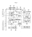
- Fig. 3 illustrates a detailed construction of a navigation system according to an exemplary embodiment of the present invention
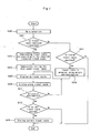
- Fig. 4 is a flowchart illustrating a method for providing a travel route in a navigation system according to an exemplary embodiment of the present invention
- Fig. 5 is a flowchart illustrating a method for providing a travel route in a navigation system according to another exemplary embodiment of the present invention
- Fig. 6 is a node construction diagram illustrating an example of a travel route according to an exemplary embodiment of the present invention
- Fig. 7 is a map construction diagram illustrating an example of storing a travel route according to an exemplary embodiment of the present invention.
- Fig. 8 illustrates an example of selecting a travel route using a hot key according to an exemplary embodiment of the present invention.
- Fig. 9 is a map construction diagram illustrating an example of storing a travel route according to another exemplary embodiment of the present invention.
- a navigation system includes: a traffic information center 210 for collecting and providing traffic information on the flow of vehicles; a navigation system 240 installed in a moving object 230 to search and determine a travel route by using location data received from a plurality of GPS satellites 200 and a map data stored in a memory, and to use a traffic information service; and a mobile communication network 220 for enabling a wireless communication between the traffic information center 210 and the navigation system 240.
- the navigation system 240 detects the current location of the moving object 230 by using the location data received from the plurality of GPS satellites 200 and signals sensed by a plurality of sensors, which are installed in the moving object 230, such as a gyro sensor for sensing a direction of travel of the moving object and a velocity sensor for sensing a travel velocity of the moving object.
- a plurality of sensors which are installed in the moving object 230, such as a gyro sensor for sensing a direction of travel of the moving object and a velocity sensor for sensing a travel velocity of the moving object.
- the navigation system 240 map-matches the detected current locations of the moving object 230 with the map data stored in the memory, and search a travel route from the current location to the destination by using the map data. Additionally, the navigation system has a function of searching and guiding the optimum route, which allows the moving object to travel to the destination along the searched and determined travel route.
- the navigation system 240 requests service information, such as real-time traffic information, route guidance information and telephone connection, to the traffic information center 210 through the mobile communication network 220 (S201 and S202). Additionally, the navigation system 240 receives traffic information service from the traffic information center 210 through the mobile communication network 220 (S203 and S204).
- service information such as real-time traffic information, route guidance information and telephone connection
- Fig. 3 is a block diagram of a navigation system according to the present invention.
- the navigation system includes an interface board 306, a main board 327, an audio board 342 for processing an audio signal, and a vehicle interface 363.
- the interface board 306 is connected between the main board 327 and the audio board 342, and an LCD 300 and a front board 303, and performs an interface function therebetween.
- the main board 327 includes a central processing unit (CPU) 336 for controlling the system; a memory 339 for storing the map information which is necessary to display the travel route on the map of a road where the moving object travels, and storing the traveling route; an input key control unit 330 for controlling an input key signal; and an LCD control unit 333 for controlling a display operation of LCD.
- CPU central processing unit
- memory 339 for storing the map information which is necessary to display the travel route on the map of a road where the moving object travels, and storing the traveling route
- an input key control unit 330 for controlling an input key signal
- an LCD control unit 333 for controlling a display operation of LCD.
- the main board 327 is connected via cable or directly to a CDMA communication unit 315, a GPS receiver 318 for receiving GPS signals, a CD deck 321 for reproducing and recoding signals of disk (CD, DVD, etc.), and a gyro 324.
- the CDMA communication unit 315 is a mobile communication terminal having an equipment identification number.
- the CDMA communication unit 315 and the GPS receiver 318 receive signals through antennas 309 and 312, respectively.
- a TV module 372 is connected to the main board 327 to receive TV signals through a TV antenna 375.
- the LCD 300 and the front board 303 are connected to the main board 327 through the interface board 306.
- the LCD 300 and the front board 303 are controlled by the LCD control unit 333 and the key control unit 330, respectively.
- the LCD 300 functions to display a variety of video and non-video, including character, signals.
- the front board 303 includes various buttons and provides a corresponding input key signal of a selected input button to the main board.
- the front board 303 includes a menu key or button for directly inputting the traffic information according to an embodiment of the present invention.
- the audio board 342 interfaces with the main board 327 and includes a microcomputer 354, a tuner 351 for receiving a radio signal, a power supply 345, and a signal processing unit 348 for processing signals to output a variety of audio signals.
- a radio antenna 357 for receiving the radio signal, a tape deck 360 for reproducing an audiotape, and an amp 369 for outputting the audio signal are connected to the audio board 342.
- the audio board 342 is connected to the interface board 306.
- the vehicle interface 363 is an interface means for transmitting/receiving signals to/from the amp 369 and hand-free/air bag/velocity sensor 366, which are mounted on the moving object, and transmits/receives signals to/from the audio board 342 and the main board 327.
- the velocity sensor for sensing the velocity of the moving object, the air bag for securing a safety, and the hand-free 366 for receiving an audio signal without using the driver's own hands are connected to the vehicle interface 363.
- the velocity sensor provides the velocity information to the central processing unit 326 in order to sense the velocity of the moving object.
- the navigation system is a combination system that can provide a variety of wireless data services, a mobile communication and broadcasting reception through a connection to a variety of audio and video devices and an addition of a telematics function, as well as the navigation service of the moving object.
- the CDMA communication unit 315 wirelessly transmits/receives signals to/from the mobile communication network through the antenna 309.
- the received signal is transmitted to the audio board 342 under a control of the central processing unit 327 and then processed through the signal-processing unit 348 of the audio board 342. Then, the processed signal is outputted through the amp 369 under a control of the microcomputer 354.
- the TV signal received through the TV antenna 375 for the purpose of receiving TV broadcasting is processed through the TV module 372. Then, the processed TV reception signal is displayed in a form of a video signal on the LCD 300 through the interface board 306 under a control of the LCD control unit 333. Additionally, the audio signal of the TV reception signal is outputted through the audio board 342 and the amp 369.
- An audio signal of the radio signal that is received through the tuner 351 for the purpose of the radio broadcasting and an audio signal of an audio tape that is received through the tape deck 360 are outputted through the audio board 342 and the amp 369.
- the audio signal reproduced through the deck 321 is also outputted through the amp 369, and a variety of the video signals are displayed on the display unit, i.e., the LCD 300.
- the user can use the navigation system to select and input traffic information of various variable environments that can occur with respect to a road on which a vehicle can travel, that is, traffic stagnation, traffic retardation, slow traffic movement, traffic accident(s), road(s) under-construction, and the like.
- the user can allow the selected traffic information, the moving object travel velocity, and the current location of the moving object to be transmitted with a message to the traffic information center.
- the user inputs the origin and the destination corresponding to the travel route.
- the received origin and destination is transmitted to the central processing unit 336 through a key control unit 330 installed in the main board 327 that is connected to the interface board 306, thereby requesting the traveling route corresponding to the received origin and destination (S401).
- the CPU 336 recognizes the current location and the traveling direction of the moving object on the basis of the GPS signal to track the travel trace, and searches the travel route from the origin to the destination inputted by the user.
- the LCD control unit 333 controls to read the travel route from the memory 339 under the control of the CPU 336 to display the travel route on the LCD 300 through the interface board 306. Further, the travel route corresponding to the origin and the destination can be downloaded from the traffic information center (S403).
- the travel route is an optimal traveling route, and is temporarily stored in the memory until the moving object arrives at the destination (S405).
- the optimal travel route is preferably selected by the user or by a predetermined reference from the map data read from the memory or from the routes downloaded from the traffic information center.
- the user can select a via or a specific on-road as the travel route.
- the stored travel route is displayed on the LCD display unit such that the user can select one of the stored traveling routes (S419). That is, the previously stored origin and destination is displayed together with the hot key such that the user can easily recognize and select the travel route. Accordingly, the user determines the origin and the destination to select the travel route by using the hot key.
- the selected travel route is displayed on the LCD 300 (S407), to guide the moving object traveling on the road (S409).
- a determination concerning whether or not the moving object arrives at the destination is made (S411). Then, if the moving object arrives at the destination, it is inquired of the user whether or not a current travel route would be stored (S413). If the user selects to store the current travel route, the current travel route is stored in a predetermined area of the storage unit (S415).
- a traffic information message containing an audio signal is received from the traffic information center.
- the central processing unit 336 outputs the received traffic information to the audio board 342.
- the audio board 342 processes the received traffic information into a voice signal through the signal-processing unit 348 and outputs the voice signal to an exterior through the amp 369 under a control of the microcomputer 354. Accordingly, the user can hear the traffic information of the second moving object in a voice.
- the voiced traffic information can be also stored together with the travel route.
- a method for providing a travel route according to another embodiment of the present invention is described as below with reference to Fig. 5 .
- a user inputs an origin and a destination (S500)
- the received origin and destination is recognized (S501) and then, a travel route for the received origin and destination is searched among travel routes that are stored in a memory by the user (S503).
- an optimal travel route corresponding to the received origin and destination is searched from map data of the memory (S515).
- the travel route with the shortest distance to the destination is determined and selected among the searched travel routes (S517), and the selected travel route is displayed for guidance (S507).
- the optimal travel route can be also requested and downloaded from a traffic information center.
- a current location of the moving object is compared with the destination of the travel route to determine whether or not the moving object arrives at the destination (S509). If the moving object arrives at the destination, it is inquired of the user whether or not the current travel route would be stored (S511).
- the travel route is stored in a predetermined area of the memory (S513).
- a node A1 refers to an origin node
- nodes A2 to A4 refer to a via node
- a node A5 refers to a destination node (Node n).
- the nodes, the origin, the destination, the via and the like are stored as the travel route.
- the via can be also stored, as the traveling route, with the vicinity of the node being limited to a general building, or being mapped to a crossroad.
- the stored travel route information includes hot key, date, origin node, via node, destination node, and travel route.
- the travel routes P1, P2, P3...P11 are each stored using the hot keys 1, 2, 3...11. Since the hot keys 1 to 3 have the same origin node A1, the destination nodes A5, B5 and Cn can be displayed together with a real destination by using the hot key. That is, when the stored travel route is displayed for the user as shown in Fig. 8 , the stored travel route can be displayed together with the destination nodes (e.g., A5, B5 and Cn) and the destinations (e.g., LG, company and Friend 1, etc.).
- the destination nodes e.g., A5, B5 and Cn
- the destinations e.g., LG, company and Friend 1, etc.
- the origin node A1 When the origin node A1 is a home or a company, different destination nodes A5, B5 and Cn are stored as a first group with reference to the origin node A1. For example, hot keys 1 to 10 have the travel routes with the origin nodes being the home and the destination nodes being different from one another.
- the hot key 11 has the travel route from the origin node Bn being an arbitrary place to the destination node A1 being a specific place.
- the hot key 11 has the travel route from a business trip place to the home.
- These travel routes can be classified as a second group (that is, for example, hot keys 11 to 20) .
- respective origins and destinations can be stored as an individual group.
- each of the travel routes can be classified as the individual group.
- the travel route stored using the hot key can be read from the memory and provided on the screen by searching the desired travel route by using a search menu key and requesting the desired travel route by using the hot key.
- the user can also select one of the travel routes that are matched with received geographical names, travel routes and the like.
- a travel route where at least two nodes are continuously connected can be also used as another stored traveling route. That is, travel routes where at least two of the via nodes (e.g., Node2, Node3 and Node4) are continuously connected, and travel routes where at least two of the via nodes (e.g., Node2-Node4) and the destination node (Node n) are continuously connected, can be used as one stored travel route.
- travel routes where at least two of the via nodes e.g., Node2, Node3 and Node4
- travel routes where at least two of the via nodes (e.g., Node2-Node4) and the destination node (Node n) are continuously connected can be used as one stored travel route.
- coordinates of the nodes except for the origin node and the destination node can be provided, and the names of buildings and crossroads that are located closely to or corresponding to the coordinates can be provided.
- grouped hot keys 20, 30-and 40 have travel routes to a friend's home, a family's home and an associate home, respectively.
- a list of the travel routes corresponding to a friend 1, a family 1 and an associate 1 can include only the origin and the destination as the geographical name and also, can include or not include a voice service .
- the travel route is stored in the memory, a user does not need to separately download the same travel route from the traffic information center when the user intends to travel along the same travel route as the stored travel route. This is so, because if it is determined by comparison that the origin and the destination are identical with a stored travel route, that stored travel route can be provided.
- the origin, the destination and the like of the travel route are stored in an individual database of the traffic information center. Accordingly, the hot key can be used to request the stored travel route corresponding to the hot key from the traffic information center.
- the traffic information center when the navigation system requests the traffic information of the optimal travel route, can provide a service of the optimal travel route by informing the user of the earlier stored travel route together with any or all variable environments on the traveling route.
- the navigation system transmits/receives the traffic information by using the mobile communication network and the wireless communication.
- the mobile communication network and the navigation system transmit the transmitted and received traffic information by using a Short Message Service (SMS) .
- SMS Short Message Service
- the present invention has an effect in that the navigation system can store the travel route of a moving object according to the user's request to repetitively provide the user with the same travel route, thereby not needing to be connected with the traffic information center for the service of the desired travel route.
- the present invention has an effect in that the navigation system can embody an additional function of repetitively using the stored travel route to the destination such that the user can construct the database.
Landscapes
- Engineering & Computer Science (AREA)
- Radar, Positioning & Navigation (AREA)
- Remote Sensing (AREA)
- Automation & Control Theory (AREA)
- Physics & Mathematics (AREA)
- General Physics & Mathematics (AREA)
- Signal Processing (AREA)
- Navigation (AREA)
Claims (7)
- Vorrichtung zum Bereitstellen einer Fahrtroute in einem Navigationssystem (240), wobei die Vorrichtung aufweist:einen GPS- (Global Positioning System) Empfänger (318), der dafür konfiguriert ist, Positionsdaten von mehreren GPS-Satelliten zu empfangen;eine Speichereinheit (339), die dafür konfiguriert ist, Kartendaten und Fahrtrouteninformation mit mehreren Fahrtrouten bereitzustellen;eine Eingabeeinheit (303), die dafür konfiguriert ist, verschiedenartige Eingabetastensignale und einen Ausgangsort und einen Zielort zu empfangen;eine Displayeinheit (300), die dafür konfiguriert ist, die Kartendaten und/oder die Fahrtrouteninformation darzustellen; undeine Steuereinheit (336), die dafür konfiguriert ist, folgende Schritte auszuführen, wenn das Navigationssystem auf einen Eingabemodus geschaltet ist, in dem ein Benutzer den Ausgangsort und den Zielort eingibt:Suchen einer Fahrtroute vom Ausgangsort zum Zielort, nachdem der Benutzer den Ausgangsort und den Zielort in die Eingabeeinheit (303) eingegeben hat;Darstellen der Fahrtroute auf der Displayeinheit (300) um ein bewegtes Objekt zu führen und Ermitteln, ob die Fahrtroute gespeichert werden soll oder nicht, wenn das bewegte Objekt am Zielort angekommen ist; undSpeichern der Fahrtroute, wenn der Benutzer das Speichern der Fahrtroute in der Speichereinheit (339) auswählt;gekennzeichnet durchmehrere Hotkeys (1, 2, ..., 11), die dafür konfiguriert sind, im Eingabemodus eine jeweilige von mehreren Fahrtrouten (P1, P2, ..., P11) in der Speichereinheit (339) zu speichern,wobei jeder Hotkey derart konfiguriert ist, dass, wenn das Navigationssystem sich in einem Suchmodus befindet, in dem der Benutzer eine gewünschte Fahrtroute sucht, die bereits in der Speichereinheit (339) gespeichert worden ist, der Ausgangsort und/oder der Zielort der entsprechenden Fahrtroute zusammen mit dem Hotkey dargestellt wird, um es dem Benutzer zu ermöglichen, die in der Speichereinheit (339) gespeicherte Fahrtroute als eine gewünschte Fahrtroute zum Führen des sich bewegenden Objekts abzurufen.
- Vorrichtung nach Anspruch 1, wobei die mehreren Fahrtouten bezüglich des Ausgangsortes oder des Zielortes gruppiert und gespeichert sind.
- Vorrichtung nach Anspruch 1, ferner mit:einer Geschwindigkeits- und Richtungserfassungseinheit, die dafür konfiguriert ist, eine Fahrtgeschwindigkeit und -richtung eines sich bewegenden Objekts zu erfassen,wobei die Steuereinheit (336) dafür konfiguriert istunter Verwendung des GPS-Empfängers (318) und der Erfassungseinheit eine Ist-Position und eine Fahrtrichtung des sich bewegenden Objekts zu erkennen, um das sich bewegende Objekt entlang einer Fahrstrecke zu verfolgen;eine optimale Fahrtroute vom Ausgangsort zum Zielort zu suchen; unddie optimale Fahrtroute darzustellen, um das sich bewegende Objekt entlang der optimalen Fahrtroute auf der Displayeinheit (300) zu führen.
- Vorrichtung nach Anspruch 3,
wobei die Steuereinheit (336) dafür konfiguriert ist, die optimale Fahrtroute unter Fahrtrouten, die von einer Verkehrsinformationszentrale (210) unter Verwendung eines Drahtloskommunikationsnetzwerks empfangen werden, und Fahrtrouten auszuwählen, die von Kartendaten der Speichereinheit (339) gesucht werden. - Verfahren zum Bereitstellen einer Fahrtroute in einem Navigationssystem (240), das einen GPS- (Global Positioning System) Empfänger (318) und eine Speichereinheit (339) aufweist, mit den Schritten:(a) (S401) Empfangen eines Ausgangsorts und eines Zielorts, die durch einen Benutzer eingegeben werden;(b) Suchen einer Fahrtroute vom Ausgangsort zum Zielort;(c) (S407, S409) Darstellen der Fahrtroute zum Führen eines sich bewegenden Objekts;(d) (S413) Darstellen einer Frage, ob die Fahrtroute in der Speichereinheit (339) des Navigationssystems (240) gespeichert werden soll oder nicht, wenn das sich bewegende Objekt am Zielort angekommen ist; und(e) (S415) Speichern der Fahrtroute in der Speichereinheit (339), wenn der Benutzer wählt, die Fahrtroute zu speichern;
gekennzeichnet durch:(f) Speichern einer jeweiligen unter mehreren Fahrtrouten (P1, P2, ..., P11) in der Speichereinheit (339) unter Verwendung mehrerer Hotkeys (1, 2, ..., 11);(g) (S417, S419) Darstellen des Ausgangsorts und/oder des Zielorts der Fahrtroute zusammen mit dem gleichen Hotkey, der zum Speichern der entsprechenden Route verwendet wurde, um es dem Benutzer zu ermöglichen, die in der Speichereinheit (339) gespeicherte Fahrtroute als eine gewünschte Fahrtroute zum Führen des sich bewegenden Objekts abzurufen,wobei die Schritte (a) bis (f) ausgeführt werden, wenn das Navigationssystem sich in einem Eingabemodus befindet, in dem der Benutzer den Ausgangsort und den Zielort eingibt, und
wobei Schritt (g) ausgeführt wird, wenn das Navigationssystem sich in einem Suchmodus befindet, in dem der Benutzer eine gewünschte Fahrtroute sucht, die bereits in der Speichereinheit (339) gespeichert worden ist. - Verfahren nach Anspruch 5, wobei Schritt (c) aufweist:Erkennen einer Ist-Position und einer Fahrtrichtung des sich bewegenden Objekts auf der Basis eines GPS- (Global Positioning System) Signals zum Verfolgen des sich bewegenden Objekts entlang einer Fahrstrecke; undSuchen einer optimalen Fahrtroute vom Ausgangsort zum Zielort;Darstellen der optimalen Fahrtroute zum Führen des sich bewegenden Objekts entlang der optimalen Fahrtroute.
- Verfahren nach Anspruch 6, wobei die optimale Fahrtroute unter Fahrtrouten, die von einer Verkehrsinformationszentrale (210) unter Verwendung eines Drahtloskommunikationsnetzwerks empfangen werden, und Fahrtrouten ausgewählt wird, die von Kartendaten der Speichereinheit (339) gesucht werden.
Applications Claiming Priority (2)
| Application Number | Priority Date | Filing Date | Title |
|---|---|---|---|
| KR2003036506 | 2003-06-05 | ||
| KR1020030036506A KR20040105199A (ko) | 2003-06-05 | 2003-06-05 | 차량정보단말기의 정보저장장치 및 방법 |
Publications (3)
| Publication Number | Publication Date |
|---|---|
| EP1484580A2 EP1484580A2 (de) | 2004-12-08 |
| EP1484580A3 EP1484580A3 (de) | 2009-08-26 |
| EP1484580B1 true EP1484580B1 (de) | 2014-05-07 |
Family
ID=33157393
Family Applications (1)
| Application Number | Title | Priority Date | Filing Date |
|---|---|---|---|
| EP04012947.0A Expired - Lifetime EP1484580B1 (de) | 2003-06-05 | 2004-06-01 | Gerät und Verfahren zum Bereitstellen von Reiserouten in einem Navigationssystem |
Country Status (4)
| Country | Link |
|---|---|
| US (1) | US8423281B2 (de) |
| EP (1) | EP1484580B1 (de) |
| KR (1) | KR20040105199A (de) |
| CN (1) | CN100371680C (de) |
Families Citing this family (27)
| Publication number | Priority date | Publication date | Assignee | Title |
|---|---|---|---|---|
| KR100750632B1 (ko) * | 2005-12-30 | 2007-08-20 | 삼성전자주식회사 | 양방향 교통정보 제공 방법 및 그 장치 |
| US20080140459A1 (en) * | 2006-12-07 | 2008-06-12 | International Business Machines Corporation | Automated solution for loading user-entered navigational data into the navigation system of a rental vehicle |
| CN101046393B (zh) * | 2007-04-18 | 2011-07-27 | 江苏华科导航科技有限公司 | 导航仪的路径导航学习方法 |
| KR100935535B1 (ko) * | 2007-04-27 | 2010-01-07 | 팅크웨어(주) | 네비게이션 시작/종료 시점의 경로 관리방법 및 그 방법을이용한 네비게이션 시스템 |
| US8626208B2 (en) * | 2008-06-30 | 2014-01-07 | General Motors Llc | Traffic data transmission from a vehicle telematics unit |
| US20100036604A1 (en) | 2008-08-05 | 2010-02-11 | International Buisness Machines Corporation | Route navigation for optimal mobile coverage |
| CN101964148B (zh) * | 2009-07-24 | 2013-06-19 | 日立(中国)研究开发有限公司 | 道路交通信息记录服务器和gps用户终端 |
| US9429445B2 (en) * | 2010-11-02 | 2016-08-30 | Telenav, Inc. | Navigation system with communication identification based destination guidance mechanism and method of operation thereof |
| CN102706343A (zh) * | 2012-06-01 | 2012-10-03 | 陈耀伦 | 一种基于互联网语音导航的方法、装置和系统 |
| US20140081881A1 (en) * | 2012-09-17 | 2014-03-20 | International Business Machines Corporation | Social network based mapping |
| US20150220988A1 (en) * | 2012-10-01 | 2015-08-06 | Nokia Corporation | Method and apparatus for associating hotkeys with point of interest information |
| CN105723744A (zh) * | 2013-11-12 | 2016-06-29 | 哈曼国际工业有限公司 | 调度在线服务的数据的下载 |
| US9436182B2 (en) | 2014-05-23 | 2016-09-06 | Google Inc. | Autonomous vehicles |
| US9631933B1 (en) | 2014-05-23 | 2017-04-25 | Google Inc. | Specifying unavailable locations for autonomous vehicles |
| US9212924B1 (en) * | 2014-08-21 | 2015-12-15 | Microsoft Technology Licensing, Llc | Multimode transportation transitions |
| JP2016109434A (ja) * | 2014-12-02 | 2016-06-20 | アルパイン株式会社 | 電子機器 |
| US9733096B2 (en) | 2015-06-22 | 2017-08-15 | Waymo Llc | Determining pickup and destination locations for autonomous vehicles |
| CN107345816B (zh) * | 2016-05-06 | 2020-07-10 | 阿里巴巴(中国)有限公司 | 一种公交路线规划方法及装置 |
| CN107456363A (zh) * | 2017-08-10 | 2017-12-12 | 李海强 | 多功能导盲手杖 |
| CN107374922A (zh) * | 2017-08-10 | 2017-11-24 | 李海强 | 具有导航功能的导盲手杖 |
| CN107748925A (zh) * | 2017-09-26 | 2018-03-02 | 重庆市智权之路科技有限公司 | 行为轨迹数据提取工作方法 |
| CN107631730A (zh) * | 2017-09-26 | 2018-01-26 | 重庆市智权之路科技有限公司 | 根据地理信息数据确定轮椅行进轨迹的判断方法 |
| CN107633082A (zh) * | 2017-09-26 | 2018-01-26 | 重庆市智权之路科技有限公司 | 利用海量行为轨迹数据进行轨迹追踪以及轨迹判别的工作方法 |
| CN107588776A (zh) * | 2017-09-26 | 2018-01-16 | 重庆市智权之路科技有限公司 | 基于大数据行为轨迹信息进行医疗轮椅的行进判断方法 |
| CN107697106B (zh) * | 2017-09-29 | 2019-05-21 | 北京交通大学 | 列车进路信息的视觉距离延伸方法 |
| CN113990093B (zh) * | 2021-11-22 | 2022-10-21 | 大连理工大学 | 一种无人驾驶电动出租车动态合乘调度系统及方法 |
| US12197206B2 (en) * | 2022-09-29 | 2025-01-14 | Narma Co. Ltd. | UAV delivery and UAV operation system |
Family Cites Families (18)
| Publication number | Priority date | Publication date | Assignee | Title |
|---|---|---|---|---|
| JPH05216397A (ja) | 1991-06-14 | 1993-08-27 | Fujitsu Ten Ltd | 業務用ナビゲーション装置 |
| DE69428505T2 (de) * | 1993-12-27 | 2002-06-06 | Aisin Aw Co., Ltd. | Kartenanzeigesystem |
| US6680674B1 (en) * | 1994-04-13 | 2004-01-20 | Seiko Instruments Inc. | Adaptive geographic mapping in vehicle information systems |
| EP0920535B1 (de) * | 1996-08-26 | 2007-11-14 | Invitek Gesellschaft für Biotechnik & Biodesign mbH. | Verfahren zum nachweis klinisch relevanter veränderungen der dns-sequenz des ki-ras-onkogens, seine verwendung und testkit zur früherkennung von tumoren |
| KR19990058344A (ko) | 1997-12-30 | 1999-07-15 | 오상수 | 메모리기능을 이용한 차량항법시스템의 경로탐색방법 및 그장치 |
| EP2009608A3 (de) * | 1998-11-23 | 2009-09-23 | Integrated Transport Information Services Limited | System zur sofortigen Verkehrsüberwachung |
| US20020129148A1 (en) * | 1999-01-25 | 2002-09-12 | Peter Ritz | Method and system for identifying traffic conditions |
| JP3521817B2 (ja) * | 1999-10-26 | 2004-04-26 | 株式会社エクォス・リサーチ | ナビゲーション装置 |
| DE60132844T2 (de) * | 2000-04-28 | 2009-02-19 | Matsushita Electric Industrial Co., Ltd., Kadoma-shi | Interaktives Navigationssystem |
| US6751548B2 (en) * | 2000-11-20 | 2004-06-15 | Max Fox | Matching stored routes to a required route |
| US7191409B2 (en) * | 2000-12-08 | 2007-03-13 | Micron Technology, Inc. | Method and apparatus for programming hot keys based on user interests |
| JP4497748B2 (ja) * | 2001-04-27 | 2010-07-07 | パイオニア株式会社 | ナビゲーション装置、ナビゲーションシステム用のサーバ装置、目的地推定処理プログラムおよび目的地推定処理プログラムを記録した記録媒体 |
| US6446002B1 (en) * | 2001-06-26 | 2002-09-03 | Navigation Technologies Corp. | Route controlled audio programming |
| DE10131800A1 (de) * | 2001-06-30 | 2003-01-16 | Bosch Gmbh Robert | Verfahren zum Betrieb eines Navigationssystems für ein Fahrzeug, insbesondere ein Kraftfahrzeug und Navigationssystem |
| KR100401158B1 (ko) | 2001-07-19 | 2003-10-10 | 주식회사 현대오토넷 | 정보단말기를 이용한 차량항법 시스템 및 그 방법 |
| US6754550B2 (en) * | 2001-10-18 | 2004-06-22 | Hurco Companies, Inc. | Toleranced digitizing method |
| EP1443308B9 (de) * | 2001-11-05 | 2010-12-22 | Aisin Aw Co., Ltd. | Fahrzeugnavigationsvorrichtung und -verfahren |
| JP3955472B2 (ja) * | 2002-01-10 | 2007-08-08 | 三菱電機株式会社 | ナビゲーション装置および地図情報記憶媒体および交差点地先情報提供方法 |
-
2003
- 2003-06-05 KR KR1020030036506A patent/KR20040105199A/ko not_active Ceased
-
2004
- 2004-06-01 EP EP04012947.0A patent/EP1484580B1/de not_active Expired - Lifetime
- 2004-06-04 US US10/859,980 patent/US8423281B2/en not_active Expired - Fee Related
- 2004-06-04 CN CNB2004100488416A patent/CN100371680C/zh not_active Expired - Fee Related
Also Published As
| Publication number | Publication date |
|---|---|
| CN1573294A (zh) | 2005-02-02 |
| US20040249569A1 (en) | 2004-12-09 |
| CN100371680C (zh) | 2008-02-27 |
| EP1484580A2 (de) | 2004-12-08 |
| EP1484580A3 (de) | 2009-08-26 |
| US8423281B2 (en) | 2013-04-16 |
| KR20040105199A (ko) | 2004-12-14 |
Similar Documents
| Publication | Publication Date | Title |
|---|---|---|
| EP1484580B1 (de) | Gerät und Verfahren zum Bereitstellen von Reiserouten in einem Navigationssystem | |
| EP1447647B1 (de) | Gerät und Verfahren zum Bereitstellen von Information über die Position eines anderen Teilnehmers in einem Navigationssystem | |
| EP1439373B1 (de) | Vorrichtung und Verfahren zum Bereitstellen von Verkehrsinformationen in einem Navigationssystem | |
| JP3974111B2 (ja) | 交通情報出力装置 | |
| JP4497748B2 (ja) | ナビゲーション装置、ナビゲーションシステム用のサーバ装置、目的地推定処理プログラムおよび目的地推定処理プログラムを記録した記録媒体 | |
| JP3045013B2 (ja) | ナビゲーション装置 | |
| EP1503355B1 (de) | Eine Vorrichtung, System und Verfahren für die Verarbeitung von statistischen Verkehrsinformationen | |
| US6859720B2 (en) | Traffic-information distribution method on-vehicle navigation apparatus | |
| US20110022305A1 (en) | Car navigation apparatus, a portable information terminal and a car navigation system | |
| KR20010036842A (ko) | 지피에스와 무선통신망을 이용한 버스의 위치 및 운행 정보 서비스 시스템 및 서비스 방법 | |
| KR20090073666A (ko) | 메신저로 위치 정보를 교환하는 내비게이션 시스템 및 방법 | |
| US20140046594A1 (en) | Mobile-body navigation device and mobile-body navigation system | |
| JP2003207353A (ja) | ネットワークナビゲーションシステム及びナビゲーション装置 | |
| JP4163741B1 (ja) | ナビゲーションシステム、経路探索サーバおよび携帯端末装置ならびに経路探索方法 | |
| JP6962659B2 (ja) | 電子装置 | |
| JPWO2006112172A1 (ja) | ナビゲーション装置 | |
| KR20050050361A (ko) | 사용자 선호 구간을 고려한 경로 안내를 위한 네비게이션시스템 및 방법 | |
| JP2007232727A (ja) | ナビゲーションシステム | |
| JP3906245B2 (ja) | ナビゲーションシステム | |
| JP4696253B2 (ja) | 移動経路設定装置、移動経路報知装置、および移動経路報知システム | |
| JP4228759B2 (ja) | 情報端末装置 | |
| JP3675350B2 (ja) | ナビゲーションシステムおよびカーナビゲーション装置 | |
| JPH09259385A (ja) | 道案内システム | |
| JP2008122340A (ja) | ナビゲーション装置 | |
| JP4606845B2 (ja) | ナビゲーション装置 |
Legal Events
| Date | Code | Title | Description |
|---|---|---|---|
| PUAI | Public reference made under article 153(3) epc to a published international application that has entered the european phase |
Free format text: ORIGINAL CODE: 0009012 |
|
| 17P | Request for examination filed |
Effective date: 20040701 |
|
| AK | Designated contracting states |
Kind code of ref document: A2 Designated state(s): AT BE BG CH CY CZ DE DK EE ES FI FR GB GR HU IE IT LI LU MC NL PL PT RO SE SI SK TR |
|
| AX | Request for extension of the european patent |
Extension state: AL HR LT LV MK |
|
| RIN1 | Information on inventor provided before grant (corrected) |
Inventor name: OH, HWAN SAENG |
|
| PUAL | Search report despatched |
Free format text: ORIGINAL CODE: 0009013 |
|
| AK | Designated contracting states |
Kind code of ref document: A3 Designated state(s): AT BE BG CH CY CZ DE DK EE ES FI FR GB GR HU IE IT LI LU MC NL PL PT RO SE SI SK TR |
|
| AX | Request for extension of the european patent |
Extension state: AL HR LT LV MK |
|
| AKX | Designation fees paid |
Designated state(s): DE FR GB IT |
|
| 17Q | First examination report despatched |
Effective date: 20110404 |
|
| GRAP | Despatch of communication of intention to grant a patent |
Free format text: ORIGINAL CODE: EPIDOSNIGR1 |
|
| INTG | Intention to grant announced |
Effective date: 20131120 |
|
| GRAS | Grant fee paid |
Free format text: ORIGINAL CODE: EPIDOSNIGR3 |
|
| GRAA | (expected) grant |
Free format text: ORIGINAL CODE: 0009210 |
|
| AK | Designated contracting states |
Kind code of ref document: B1 Designated state(s): DE FR GB IT |
|
| REG | Reference to a national code |
Ref country code: GB Ref legal event code: FG4D |
|
| RIN1 | Information on inventor provided before grant (corrected) |
Inventor name: OH, HWAN SAENG |
|
| REG | Reference to a national code |
Ref country code: DE Ref legal event code: R096 Ref document number: 602004045006 Country of ref document: DE Effective date: 20140612 |
|
| REG | Reference to a national code |
Ref country code: DE Ref legal event code: R097 Ref document number: 602004045006 Country of ref document: DE |
|
| PLBE | No opposition filed within time limit |
Free format text: ORIGINAL CODE: 0009261 |
|
| STAA | Information on the status of an ep patent application or granted ep patent |
Free format text: STATUS: NO OPPOSITION FILED WITHIN TIME LIMIT |
|
| 26N | No opposition filed |
Effective date: 20150210 |
|
| GBPC | Gb: european patent ceased through non-payment of renewal fee |
Effective date: 20140807 |
|
| PG25 | Lapsed in a contracting state [announced via postgrant information from national office to epo] |
Ref country code: IT Free format text: LAPSE BECAUSE OF FAILURE TO SUBMIT A TRANSLATION OF THE DESCRIPTION OR TO PAY THE FEE WITHIN THE PRESCRIBED TIME-LIMIT Effective date: 20140507 |
|
| REG | Reference to a national code |
Ref country code: FR Ref legal event code: PLFP Year of fee payment: 12 |
|
| REG | Reference to a national code |
Ref country code: DE Ref legal event code: R097 Ref document number: 602004045006 Country of ref document: DE Effective date: 20150210 |
|
| PG25 | Lapsed in a contracting state [announced via postgrant information from national office to epo] |
Ref country code: GB Free format text: LAPSE BECAUSE OF NON-PAYMENT OF DUE FEES Effective date: 20140807 |
|
| REG | Reference to a national code |
Ref country code: FR Ref legal event code: PLFP Year of fee payment: 13 |
|
| REG | Reference to a national code |
Ref country code: FR Ref legal event code: PLFP Year of fee payment: 14 |
|
| REG | Reference to a national code |
Ref country code: FR Ref legal event code: PLFP Year of fee payment: 15 |
|
| PGFP | Annual fee paid to national office [announced via postgrant information from national office to epo] |
Ref country code: FR Payment date: 20220512 Year of fee payment: 19 Ref country code: DE Payment date: 20220506 Year of fee payment: 19 |
|
| REG | Reference to a national code |
Ref country code: DE Ref legal event code: R119 Ref document number: 602004045006 Country of ref document: DE |
|
| PG25 | Lapsed in a contracting state [announced via postgrant information from national office to epo] |
Ref country code: DE Free format text: LAPSE BECAUSE OF NON-PAYMENT OF DUE FEES Effective date: 20240103 |
|
| PG25 | Lapsed in a contracting state [announced via postgrant information from national office to epo] |
Ref country code: FR Free format text: LAPSE BECAUSE OF NON-PAYMENT OF DUE FEES Effective date: 20230630 |