EP1677078A2 - Système et procédé de navigation - Google Patents
Système et procédé de navigation Download PDFInfo
- Publication number
- EP1677078A2 EP1677078A2 EP05257900A EP05257900A EP1677078A2 EP 1677078 A2 EP1677078 A2 EP 1677078A2 EP 05257900 A EP05257900 A EP 05257900A EP 05257900 A EP05257900 A EP 05257900A EP 1677078 A2 EP1677078 A2 EP 1677078A2
- Authority
- EP
- European Patent Office
- Prior art keywords
- image
- information
- route
- vehicle
- guidance
- Prior art date
- Legal status (The legal status is an assumption and is not a legal conclusion. Google has not performed a legal analysis and makes no representation as to the accuracy of the status listed.)
- Withdrawn
Links
- 238000000034 method Methods 0.000 title description 23
- 238000004891 communication Methods 0.000 claims description 21
- 230000008859 change Effects 0.000 claims description 3
- 238000012545 processing Methods 0.000 description 34
- 238000010586 diagram Methods 0.000 description 15
- 230000008569 process Effects 0.000 description 15
- 230000008901 benefit Effects 0.000 description 8
- 238000013459 approach Methods 0.000 description 5
- 238000004590 computer program Methods 0.000 description 5
- 230000000007 visual effect Effects 0.000 description 3
- 239000000284 extract Substances 0.000 description 2
- 230000005540 biological transmission Effects 0.000 description 1
- 230000015572 biosynthetic process Effects 0.000 description 1
- 239000003086 colorant Substances 0.000 description 1
- 238000013461 design Methods 0.000 description 1
- 238000011156 evaluation Methods 0.000 description 1
- 230000006870 function Effects 0.000 description 1
- 238000012986 modification Methods 0.000 description 1
- 230000004048 modification Effects 0.000 description 1
- 230000002093 peripheral effect Effects 0.000 description 1
- 238000003786 synthesis reaction Methods 0.000 description 1
Images



Classifications
-
- G—PHYSICS
- G01—MEASURING; TESTING
- G01C—MEASURING DISTANCES, LEVELS OR BEARINGS; SURVEYING; NAVIGATION; GYROSCOPIC INSTRUMENTS; PHOTOGRAMMETRY OR VIDEOGRAMMETRY
- G01C21/00—Navigation; Navigational instruments not provided for in groups G01C1/00 - G01C19/00
- G01C21/26—Navigation; Navigational instruments not provided for in groups G01C1/00 - G01C19/00 specially adapted for navigation in a road network
- G01C21/34—Route searching; Route guidance
- G01C21/36—Input/output arrangements for on-board computers
- G01C21/3626—Details of the output of route guidance instructions
Definitions
- the present invention relates to a system and method for navigation and particularly, but not exclusively, to a step-by-step navigation system and method in which a vehicle or other movable body is guided from a starting point to a destination.
- the step-by-step navigation systems require only minimal functionality, and the device is inexpensive. This is an advantage. More specifically, the display unit does not require high performance, and there is also no need to have a large-capacity storage device that can store large amounts of map imagery.
- the driver watches and checks the display unit with less frequency . As a result, driving the vehicle becomes safer. This is also an advantage.
- the present invention provides a navigation system for guiding a vehicle as set out in the appended claims.
- a navigation system for guiding a movable object from a starting point to a destination.
- the system includes a user interface adapted to accept information pertaining to the destination and the starting point; a route computing module in communication with the user interface and adapted to generate a route from the starting point to the destination and to generate driving directions or other guidance information for guidance along the route, the guidance information including at least one turning point on the route; an image data generation module adapted to generate at least one map image for a prescribed range around the turning point; a position information acquisition module that outputs the position of the movable body; a display image generation module responsive to the moveable body position detector to superimpose on the map image an indicia indicating the position of the movable body when the movable body is within the prescribed range of the prescribed site; and a display adapted to display the guidance information, the map image, and the indicia superimposed on the map image to indicate the position of the movable body.
- a method for navigating a movable object from a starting point to a destination.
- the method includes: inputting the information pertaining to the destination and starting point; using a database of map information, computing a route for the moving body from the starting point to the destination point; determining at least one prescribed site along the route where the course of the moving body will change; generating a map image for an area within a prescribed range of the prescribed site; determining the location of the movable body; and if the movable body is within the prescribed range of the prescribed site, displaying the map image with the indicia superimposed on the map image to indicate the location of the movable body.
- a server for generating information for navigating a movable body from a starting point to a destination.
- the server includes an input to receive the starting point and destination; memory on which is stored map image information and route information; a route computing module in communication with the user interface and adapted to generate a route from the starting point to the destination and to generate driving directions or other guidance information for guidance along the route, the guidance information including at least one turning point on the route; an image data generation module responsive to the route computing module and adapted to generate at least one map image for a prescribed range around the turning point.
- a movable body terminal device for use in a navigation system.
- the terminal device includes: a receiver adapted to receive guidance information for the route, including at least one prescribed site, and map image information for an area within a prescribed range around the prescribed site; a position information acquisition module that outputs the position of the movable body; a display image generation module responsive to the position information acquisition module to superimpose on the map image information an indicia indicating the position of the movable body when the movable body is within the prescribed range of the prescribed site; and a display adapted to display the guidance information, the map image information and the indicia superimposed on the map image information to indicate the position of the movable body.
- a computer program product for a server used in a navigation system.
- the computer program product includes computer-readable medium having a control logic stored therein for causing a computer to accept as input a starting point and a destination; determine a route from the starting point to the destination using map data, which route includes at least one prescribed site where guidance information will be provided to a user; generate guidance information including map image information for an area within a prescribed range of the prescribed site.
- a computer program product for in a movable body terminal device used in a navigation system.
- the computer program product includes a computer-readable medium having a control logic stored therein for causing a computer to: accept as input guidance information for the route from the destination to the starting point and map image information for at least one area within a prescribed range around at least one prescribed site on the route; accept as input the position of the movable body; superimpose on the map image information an indicia indicating the position of the movable body when the movable body is within the prescribed range of the prescribed site; and display the guidance information, the map image information and indicia imposed on the map image information to indicate the position of the movable body.
- a system, method and/or computer program are provided for navigation which maintains benefits of step-by-step navigation systems while providing map information.
- a navigation system and method that maintains advantages of the step-by-step navigation system are maintained, while providing map information to facilitate navigation when route guidance is provided.
- the present invention provides a type of server for a guide system for providing the guide system and guide method, its movable body terminal device, a guidance information provision processing program, and a program for the guide system terminal device.
- a navigation system that is carried aboard the vehicle and guides the driver of the vehicle (also called the user) along the route to the destination (hereinafter to be referred to as a navigation system) as an example.
- FIG. 1 is a block diagram illustrating the overall constitution of a navigation system 1.
- the navigation system 1 comprises a service provider 20, an information terminal 100 and a communication module 180 carried aboard a vehicle 10, a communications provider 50, and a communications network 90, which in this case is the Internet.
- the service provider 20 determines the route for guiding vehicle 10 from the starting point to the destination based on the starting point and destination information for vehicle 10 input through information terminal 100 of vehicle 10 via network 90, generates the information for guiding vehicle 10 on the route, and provides this to information terminal 100.
- the service provider 20 has the following modules: an input/output control module 210, a map database 220, a route computing module 230, an image data generation module 240, a temporary storage module 250, and a communication module 260.
- the input/output control module 210 performs communication with information terminal 100 via communication module 260 and network 90, and it receives the user's request for route guidance. After receipt of the request, it transmits the information generated by service provider 20 via communication module 260 and network 90 to information terminal 100.
- the map database 220 is a database for storing various information for determining the route from the starting point to the destination after a request from information terminal 100, and for guiding the driver on the route.
- map database 220 can store the road information, map information, etc., for all of Japan.
- route computing module 230 determines or computes the actual route with reference to map database 220. For example, the route is determined taking into consideration the total length of the route, the time demanded, road conditions, condition of vehicle 10, etc.
- the map information and road information recorded in map database 220 and the information on conditions input together with the user's request for route guidance from information terminal 100 (vehicle 10) are used as the evaluation information that takes into consideration the conditions.
- route computing module 230 When the route appropriate to the requested conditions is determined, route computing module 230 generates the guide information for guiding vehicle 10 along the route, that is, the names of the road on the route, the travel distance to landmarks or the destination, the names of intersections where left/right turns are made, etc.
- the guidance information is generated as text information.
- the generated guidance information is stored in temporary storage module 250.
- route computing module 230 outputs the information pertaining to the determined route to image data generation module 240 for generating the image data for route guidance.
- route computing module 230 may determine a unique route or plural routes according to the route determination conditions from information terminal 100.
- the image data generation module 240 generates the image data by which information terminal 100 guides the driver of vehicle 10 on the route determined by route computing module 230.
- image data generation module 240 generates the image data for guidance by means of the following processing.
- Image data generation module 240 determines the sites on the determined route where the course (movement direction) should be changed, such as turning right/left at an intersection, etc. (hereinafter “turning points"), as sites on the route where the course of the movable body should be guided or as sites where the map image is formed .
- image data generation module 240 extracts from map database 220 the map image information in the prescribed ranges that have the sites at the center.
- image data generation module 240 superimposes prescribed characteristic lines (such as wide lines, lines in prescribed colors, etc.) on the road and course constituting the guidance route to facilitate visual recognition.
- prescribed characteristic lines such as wide lines, lines in prescribed colors, etc.
- the central position information (that is, the position of the site on the route where the course of the movable body should be guided), the information indicating the range of the map image, the information indicating the scale of the map image, etc., are attached as appended information to form the image data provided to the user.
- the latitude and longitude information for the site are used as the information indicating the central position of the map image.
- the generated image data (including the appended information) is temporarily stored in temporary storage module 250.
- the temporary storage module 250 stores the guidance information generated in route computing module 230 corresponding to the user's request for route guidance and the image data generated in image data generation module 240.
- the information stored in temporary storage module 250 is sent under the control of input/output control module 210 from communication module 260 to information terminal 100 via network 90.
- Communication module 260 is a communication control means allowing service provider 20 to communicate with information terminal 100 of vehicle 10 via network 90.
- the information terminal 100 carried on vehicle 10 is a terminal device that displays the information provided by service provider 20 to the driver of vehicle 10, and that guides the driver of vehicle 10 with the route to the destination.
- the information terminal 100 has the following modules: arithmetic operation module 110, display module 120, display image generation module 130, operation input module 140, position information acquisition module 150, interface 160, and storage module 170.
- the arithmetic operation module 110 performs overall control of information terminal 100, and performs processing of the route that guides the driver of vehicle 10.
- the display module 120 is a display unit for displaying the route information that guides the driver of vehicle 10.
- display image generation module 130 Based on the guidance information and image data provided by service provider 20, display image generation module 130 generates the image to be displayed on display module 120 for the driver.
- the operation input module 140 is a means for the driver of vehicle 10 to operate information terminal 100.
- the driver of vehicle 10 performs operations via operation input module 140 such as inputting the starting point or destination of vehicle 10, transmission of the input information to service provider 20, reception of the guidance information and image data from service provider 20, instructions for starting the route guidance operation, etc.
- the position information acquisition module 150 is a means for determining the position of vehicle 10, and in this embodiment, it is a GPS device.
- the interface 160 is an interface between information terminal 100 and communication module 180.
- storage module 170 is a storage means that stores the route guidance information and image data downloaded from service provider 20.
- the communication module 180 carried on vehicle 10 is a communication means that is connected via communications provider 50 to network 90.
- information terminal 100 can communicate with service provider 20 via network 90, and it can access services from service provider 20.
- Figure 2 is a flow chart illustrating the processing flow in providing the guidance information from service provider 20 to information terminal 100.
- Figure 3 is a diagram illustrating the processing.
- the user of vehicle 10 accesses the web site of service provider 20 from information terminal 100 via network 90.
- information terminal 100 is connected to service provider 20 so that service provider can provide service (step S110).
- service provider 20 Upon being accessed by information terminal 100, service provider 20 judges whether there is a request from information terminal 100 for route guidance information (step S111). If there is no request for route guidance information (NO in step S111), a judgment is made as to whether the user has terminated the service access (step S120). If it has been terminated (YES in step S120), the access from information terminal 100 is cut off (step S119, and the information terminal 100 processing comes to an end (step S190).
- step S120 if the service (access) has not been terminated in step S120 (NO in step S120), process flow returns to step S111, and the presence/absence of a request to use the service of providing route guidance information is checked.
- service provider 20 stands by for a request from information terminal 100 to use the service of providing route guidance information.
- step S111 When there is a request for route guidance information from information terminal 100 (YES in step S111), the user is prompted to input the starting point and destination to information terminal 100, and the input starting point and destination information is received and set (step S 112). Also, for example, when service provider 20 knows the current position of vehicle 10 for some reason, such as that service provider 20 has already provided the route guidance information to vehicle 10, etc., the current position information is used as the starting point, and its input from information terminal 100 can be omitted.
- step S 113 The user is then prompted to check the starting point and destination settings (step S 113. If a successful check has been made (OK, that is, YES in step S113), process flow continues to the processing of the next step, that is, computing of the route. On the other hand, if the set starting point and destination are incorrect (NG, that is, NO in step S113), a judgment is made as to whether the user has terminated the service (step S121). If the user has terminated the service (YES in step S121), access from information terminal 100 is cut off (step S119), and the processing with respect to information terminal 100 comes to an end (step S190). If the service (access) is not terminated in step S121 (NO in step S121), process flow returns to step S 112, and a request is made to information terminal 100 for input of the starting point and destination again.
- NG that is, NO in step S113
- route computing module 230 of service provider 20 uses the information of map database 220 as a reference, or uses other preset conditions, etc., as a reference, to determine the route from the starting point to the destination (step S114).
- route computing module 230 of service provider 20 uses the information of map database 220 as a reference, or uses other preset conditions, etc., as a reference, to determine the route from the starting point to the destination (step S114).
- plural routes can be determined simultaneously.
- one route 530 is determined by the route computation of step S 114.
- the guidance point information includes the latitude and longitude of the location where left/right turning, etc., is in order.
- the guidance point information becomes the step-by-step information for travel from the starting point to the destination.
- right/left turn sites 540 1 , 540 2 , and 540 3 are determined as guidance points.
- the latitude and longitude information for the guidance points and the information of the connecting routes roads between them are determined as information for the guidance points.
- an image file is formed that includes the map information near each guidance point.
- the image data generation module 240 of service provider 20 extracts map image information from map database 220 at a prescribed scale and having the destination and the various guidance points at the centers, and the road that becomes the route of the extracted map is depicted as a wide line or in a different color, so that the determined route information is superimposed on the map image to generate map image guidance information.
- image data generation module 240 takes the generated map image information as an image file in a general purpose still picture format, such as JPEG or GIF or the like, and attaches the latitude and longitude information and scale information of the central portion of the image guidance point to the image file, forming the image file for download to information terminal 100.
- a general purpose still picture format such as JPEG or GIF or the like
- map images 550A 0 , 550A 1 , 550A 2 , 550A 3 and 550A 4 are respectively extracted, and the latitude and longitude and scale information are attached to each of them to form an image file group for download.
- the service provider 20 has a series of image file groups for each guidance point downloaded to information terminal 100 (step S 117).
- an image file group is generated for each of the routes.
- step S 118 If the user demands further service (YES in step S 118), process flow returns to step S 112, and the user is prompted to input the starting point and destination of the next route guidance object. On the other hand, if there is no demand for further service (NO in step S118, access from information terminal 100 is cut off (step S119), and the processing for information terminal 100 is terminated (step S190).
- Figures 4 and 5 are flow charts illustrating the processing flow for guiding the driver of vehicle 10 from the starting point to the destination at information terminal 100.
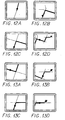
- Figures 6 and 7 are diagrams illustrating examples of display during this processing on display module 120 of information terminal 100 of vehicle 10.
- step S200 When the driver of vehicle 10 turns ON the ignition key or turns ON the power supply for information terminal 100, information terminal 100 begins operation (step S200).
- the guidance information provided by service provider 20 is stored in storage module 170 of information terminal 100 by means of the processing (step S210).
- position information acquisition module 150 begins operation. Then, within a prescribed time interval, the position information for vehicle 10 latitude and longitude is determined (step S210). In the following processing, when the position information for vehicle 10 is used, the most current position information for vehicle 10 determined by position information acquisition module 150 is used. The position information for vehicle 10 is determined on a regular basis in position information acquisition module 150 and the most current information is used. This will not be explained below.
- a list of the route information stored in storage module 170 is displayed on display module 120, and the user can select the information for the desired route to the desired destination from the list (step S212).
- arithmetic operation module 110 reads the image file of image 550A 0 of the starting point of selected route 530 and its appended information from storage module 170 (step S213).
- arithmetic operation module 110 performs a computation to determine where vehicle 10 is located on image 550A 0 (step S214), superimposes an indicia 600 (See Fig. 6A) indicating the position of vehicle 10 on image 550A 0 by means of display image generation module 130, and displays it on display module 120 (step S215).
- the image of the periphery of starting point 510 see Figure 3 is displayed on display module 120.
- the dots indicate the position of vehicle 10.
- other types of symbols or other indicia may be use to indicate the position of vehicle 10.
- arithmetic operation module 110 judges the presence/absence of vehicle 10 within the range of image 550Ai (step S218).
- step S230 If vehicle 10 is out of the range of image 550Ai (NO in step S218), a judgment is made as to whether vehicle 10 is present within the range of the image of the preceding guidance point the currently displayed image 550Ai-1 (step S230).
- the position of vehicle 10 on image 550A 0 is computed from the latitude and longitude information for the image central portion and the image scale information that are appended to the image file of the image 550Ai-1 and the current position information for vehicle 10 determined by position information acquisition module 150, (step 5231), and the position of vehicle 10 is superimposed on image 550Ai-1 and displayed on display module 120 by means of display image generation module 130 (step S232).
- the image displayed is still image 550A 0 without change, and the position of vehicle 10 moves on the displayed image.
- process flow returns to step S218, and a judgment is made as to the presence/absence of vehicle 10 within the range of image 550Ai. The processing after that is repeated.
- step S220 When vehicle 10 is not within the range of image SSOAi-1 of the preceding guidance point in step S230 (NO in step S230), image 550Ai of the ith guidance point that is expected to come next (to enter the range) is displayed (step S220). In this case, because vehicle 10 is out of the range of image 550Ai, the dot indicating the position of vehicle 10 is not superimposed in display.
- step S218 When vehicle 10 enters the range of image 550Ai of the ith guidance point (YES in step S218, the latitude and longitude information for the image central portion and the image scale information appended to the image file for image 550Ai and the current position information for vehicle 10 determined by position information acquisition module 150 are used to compute the position of vehicle 10 in image 550Ai (step S219), and the position of vehicle 10 is superimposed on image 550Ai by display image generation module 130 and displayed on display module 120 (step S220).
- i 1 as an example, the image shown in Figure 6C is displayed on display module 120.
- the displayed image is changed to image 550Ai of the next arriving guidance point, and when vehicle 10 approaches the intersection as the guidance point, its position is shown as a dot on the displayed image.
- step S221 a judgment is made as to whether vehicle 10 has passed the ith guidance point.
- a judgment as to whether the guidance point has been passed can be easily performed by determining the distance between vehicle 10 and the guidance point based on the vehicle position information and the latitude and longitude information for the guidance point. This distance diminishes as vehicle 10 approaches the guidance point, becomes nearly 0 zero when the vehicle reaches the guidance point, and then increases after passing it. It is then possible to judge whether the guidance point has been passed by determining the zero point.
- process flow returns to step S219, and the position of vehicle 10 on image 550Ai is computed from the information appended to the image file of image 550Ai and the current position information for vehicle 10 (step S219), and the position of vehicle 10 is superimposed on image 550Ai by display image generation module 130 and is displayed on display module 120 (step S220).
- the image displayed on display module 120 is the same as the preceding image 550Ai, and the position of vehicle 10 is moved to display the same image as that shown in Figure 6C.
- step S221 it is determined that the guidance point has been passed by vehicle 10, the variable i as the index for the guidance point is incremented (step S222), and the ith image 550Ai is set to become the image of the next guidance point.
- next guidance point is not the last guidance point (NO in step S223), process flow returns to step S217, and the processing of steps S217-S222 is repeated.
- one of the following images is displayed on display module 120 of vehicle 10, depending on the specific state: an image indicating the state as the vehicle moves away from the first guidance point 5401 as shown in Figure 7A, an image indicating the state as the vehicle approaches the second guidance point 5402 as shown in Figure 7B, or an image indicating the state as the vehicle approaches the third guidance point 5403, etc.
- next guidance point (the ith guidance point) is the last guidance point, that is, the destination (YES in step S223)
- the image file for image 550Ai corresponding to the guidance point (destination) and its appended information are read from storage module 170 (step S240 see Figure 5).
- the arithmetic operation module 110 judges whether vehicle 10 is present within the range of image 550Ai based on the latitude and longitude information for the image central portion and the image scale information that is appended and the current position information for vehicle 10 determined by position information acquisition module 150 (step S241).
- step S241 If vehicle 10 is not within the range of image 550Ai (NO in step S241), a judgment is made as to whether vehicle 10 is within the range of image 550Ai-1 the current displayed image of the preceding guidance point (step S250).
- step S250 If vehicle 10 is within the range of the display of image 550Ai-1 of the preceding guidance point (YES in step S250, the position of vehicle 10 on image 550Ai-1 is computed from the latitude and longitude information for the image central portion and the image scale information appended to the image file for image 550Ai-1 and the current position information for vehicle 10 determined by position information acquisition module 150 (step S251, and the position of vehicle 10 is superimposed on image 550Ai-1 by display image generation module 130 and displayed on display unit 120 (step S252).
- process flow returns to step S241, and a judgment is made from the information appended to image 550Ai and the current position information for vehicle 10, as to whether vehicle 10 is present within the range of image 550Ai, and the processing thereafter is repeated.
- step S243 When vehicle 10 is present within the range of image 550Ai-1 of the preceding guidance point (NO in step S250), image 550Ai of the destination (the ith guidance point) is displayed (step S243). In this case, because vehicle 10 is out of the range of image 550Ai, the dot indicating the position of vehicle 10 is not superimposed and displayed.
- step S241 When vehicle 10 enters the range of image 550Ai of the destination (ith guidance point) (YES in step S241), the position of vehicle 10 in image 550Ai is computed from the latitude and longitude information for the image central portion and the image scale information appended to the image file for image 550Ai and the current position information for vehicle 10 on image 550A: determined by position information acquisition module 150 (step S242), and the position of vehicle 10 is superimposed on image 550Ai by display image generation module 130, and is displayed on display module 120 (step S243). As a result, the same image as that shown in Figure 7D is displayed on display module 120.
- the judgment on whether vehicle 10 has reached the destination can be performed, for example, by determining whether the distance between the vehicle 10 and the guidance point is 0 zero from the position information for vehicle 10 and the latitude and longitude information for the guidance point.
- step S242 If vehicle 10 has not reached the destination (NO in step S244), process flow returns to step S242.
- the position of vehicle 10 on image 550Ai is computed (step S242, and the position of vehicle 10 is superimposed on image 550Ai by display image generation module 130 and displayed on display module 120 (step S243). As a result, the same image is displayed on display module 120 as the preceding image 550Ai, except that the position of vehicle 10 has been moved.
- step S244 if it is determined that vehicle 10 has reached the destination, the route guidance processing sequence comes to an end (step S290).
- navigation system 1 of this embodiment downloads to information terminal 100 and stores image data near the destination, the intersections where the vehicle turns left/right, and other guidance points.
- Other image data may be omitted, and in this manner, the amount of map image data files may be reduced while still providing route guidance to the user by means of map images used for general navigation.
- the driver of vehicle 10 can be guided on the route in a more easily understood fashion.
- the minimum necessary general purpose still image files can be used to provide the user with a guide at the guidance points in the form of a map image adopted for conventional navigation. Consequently, more effective step-by-step navigation can be realized for better practical application.
- the displayed map image is a map image stored in map database 220 of service provider 20, and it can also display other roads, peripheral landmarks, etc. Also, it is of course possible to superimpose and display the display scale information (map scale).
- the present invention will be explained with reference to an example of a step-by-step navigation system that is carried aboard the vehicle and guides the driver of the vehicle from the starting point to the destination.
- image data necessary for guidance is downloaded from service provider 20 to information terminal 100 of vehicle 10. Consequently, during the period from the time when vehicle 10 leaves the display range of image 550Ai-1 (see Figure 9); starting point 510, destination 520, route 530, and left/right guidance points 5401-5403 of Figure 9 are the same as those in Figure 3 until it enters the display range of image 550Ai, the position of the vehicle itself is not superimposed on the image displayed on display module 120.
- navigation system 1b takes this into consideration.
- this system during the period from when vehicle 10 leaves the display range of image 550Ai-1 including the (i-1)th guidance point until it enters the display range of image 550Ai including the ith guidance point, the position of vehicle 10 is not superimposed on the map image of the expanded range including the (i-1)th guidance point and the ith guidance point displayed on display module 120 of terminal 100.
- navigation system 1b is similar to that of navigation system 1 of the first embodiment shown as example in Figure 1, except that the image is generated in image data generation module 240 of service provider 20.
- image data corresponding to the various guidance points are formed in image data generation module 240, as shown in Figure 9, and in addition to the group of images 550A images 550A 0 -550A 4 of the surroundings of the guidance point just as in the first embodiment, a group of images 550B is also formed (images 550B 1 -550B 3 ) showing expanded-range map images that take the ith guidance point as the center and also include the (i-1)th guidance point.
- the two image groups formed (images 550A 0 -550A 4 and images 550B1-550B3) are stored in temporary storage module 250, and are then downloaded to information terminal 100 of vehicle 10.
- the operation and terminal for obtaining the route guidance information from service provider 20 by information terminal 100 of navigation systems 16 are similar to those in the aforementioned first embodiment with reference to Figure 2, and will not be explained again.
- the novel feature is that the generated and downloaded map image information includes added information for an expanded-range image group 550B covering a range including two consecutive guidance points.
- the downloaded guidance information is used to guide the driver of vehicle 10 from the starting point to the destination.
- an explanation will be given regarding this operation, with reference to Figures 10-13.
- Figures 10 and 11 are flow charts illustrating the processing in information terminal 100 for guiding the driver of vehicle 10 to the destination.
- Figures 12 and 13 are diagrams illustrating examples of displays on display module 120 of information terminal 100 of vehicle 10 according to this processing.
- steps S300-S317 is the same as that of steps S200-S217 in navigation system 1 in the first embodiment, with reference to Figure 4.
- step S300 when the driver of vehicle 10 turns ON the ignition key or turns ON the power supply for information terminal 100, information terminal 100 begins to operate (step S300), and the route guidance information from service provider 20 is stored in map image storage module 170 (step S310).
- step S311 When the user initiates route guidance (step S311), the user selects the information for the desired destination (step S312), and arithmetic operation module 110 reads the image file of image 550A0 of the starting point of selected route 530 along with its appended information (step S313), and then computes the position of vehicle 10 in image 550A 0 (step S314). It superimposes the position of vehicle 10 on image 550A 0 and displays it on display module 120 (step S315).
- the file for image 550Bi, with the ith guidance point at the center and containing the (i-1)th guidance point as well as its appended information, is then read from storage module 170 (step S318).
- arithmetic operation module 110 judges the presence/absence of vehicle 10 within the range of image 550Ai (step S318).
- process flow returns to step S319, and a judgment is made as to the presence/absence of vehicle 10 within the range of image 550Ai. The processing after that is repeated.
- step S322 After the display is made, a judgment is made as to whether vehicle 10 has passed the ith guidance point (step S322).
- a judgment on whether the guidance point has been passed can be performed easily by determining the distance between vehicle 10 and the guidance point from the position information for the vehicle and the latitude and longitude information for the guidance point.
- step S322 When the ith guidance point has not yet been passed (NO in step S322, process flow returns to step S320, the information appended to the image file for image 550Ai and the current position information for vehicle 10 are used to compute the position of vehicle 10 in image 550Ai (step S320), and the position of vehicle 10 is superimposed on image 550Ai by display image generation module 130 and displayed on display module 120 (step S321).
- step S322 if it is detected has that vehicle 10 passed the guidance point, the variable i indexing the guidance point is incremented (step S323), and the ith image 550Ai is set to become the image of the next guidance point.
- step S324 When the guidance point is passed and variable i is incremented, a judgment is made as to whether the next guidance point (the ith guidance point) is the last guidance point, that is, the destination (step S324).
- next guidance point is not the last guidance point (NO in step S324), process flow returns to step S317, and the processing of steps S317-S323 is repeated.
- the following images are sequentially displayed on display module 120 of vehicle 10: the image in which the position of vehicle 10 that moves between first guidance point 540 1 and second guidance point 540 2 is superimposed on image 550B 2 that contains both of these guidance points, as shown in Figure 12D; the image in which the position of vehicle 10 that moves towards image 550A 2 near second guidance point 540 2 is superimposed on the image, as shown in Figure 13A; the image in which vehicle 10 that moves between second guidance point 540 2 and third guidance point 540 3 is superimposed on image 550B 3 containing both the guidance points, as shown in Figure 13B; and the image in which the position of vehicle 10 that moves towards third guidance point 540 3 is superimposed on image 550A 3 , as shown in Figure 13C.
- the image file for image 550Ai corresponding to the guidance point (destination) and its appended information are read from storage module 170 (step S340 (see Figure 11)).
- the file for image 550Bi containing the (i-1)th guidance point at its center and its appended information is then read from storage module 170 (step S341).
- the arithmetic operation module 110 judges whether vehicle 10 is present within the range of image 550Ai from the latitude and longitude information for the image central portion and the image scale information as the appended information for image 550Ai, and the current position information for vehicle 10 determined by position information acquisition module 150 (step S342).
- process flow returns to step S342, and a judgment is made as to whether vehicle 10 is present within the range of image 550Ai, and the processing thereafter is repeated.
- step S342 When vehicle 10 is present within the range of image 550Ai of the preceding guidance point (YES in step S342), the latitude and longitude information for the image central portion and the image scale information as appended to the image file for image 550Ai and the current position information for vehicle 10 determined by position information acquisition module 150 are used to compute the position of vehicle 10 in image 550Ai (step S343), and the position of vehicle 10 is superimposed on image 550Ai by display image generation module 130 and displayed on display module 120 (step S344).
- step S345 a judgment is made as to whether vehicle 10 has reached the destination (ith guidance point) (step S345).
- the judgment on whether vehicle 10 has reached the destination can be performed, for example, by determining whether the distance between the vehicle and the guidance point is 0 from the position information for vehicle 10 and the latitude and longitude information for the guidance point.
- step S343 If vehicle 10 has not reached the destination (NO in step S345), process flow returns to step S343.
- the position of vehicle 10 in image 550Ai is computed (step S343), and the position of vehicle 10 is superimposed on image 550Ai by display image generation module 130 and displayed on display module 120 (step S344).
- step S344 the same image as the preceding image 550Ai is displayed on display module 120, except that the position of vehicle 10 has been moved.
- step S345 if it is determined that vehicle 10 has reached the destination, the route guiding processing sequence comes to an end (step S390).
- navigation system 1b of this embodiment downloads to information terminal 100 and stores image data near the destination, the intersections where the vehicle turns left/right and other guidance points.
- the driver of vehicle 10 can be guided on the route in a more easily understandable fashion, with guiding being performed by periodically reminding the driver of the position of the vehicle.
- the quantity of image data used in this case is a little larger than that of navigation system 1 in the first embodiment
- the quantity of image data used is much smaller. Consequently, just as in navigation system 1 of the first embodiment, there is no need for a large-capacity storage component for information terminal 100, and the advantage of a simple constitution of a step-by-step navigation system can be maintained.
- the expanded-range image 550Bi is established with the ith guidance point at its center.
- the scheme is not limited to this central point.
- the navigation system carried in the vehicle serves to guide the driver of the vehicle to a destination.
- the navigation system of the present invention is not limited to use in vehicles.
- the constitution may be used in cell phones or small computer devices to guide the user to a destination.
- the present invention can be adopted in any information equipment that can be transported.
- navigation system 1 has a constitution in which information terminal 100 is directly connected to the service provider.
- the present invention is not limited to this scheme.
- the following scheme can also be adopted: the information from service provider 20 is received by means of a device different from information terminal 100, and the information is transferred via a storage medium to information terminal 100. Then, the same navigation processing is performed in information terminal 100 as was previously described.
- a scheme can be adopted in which the information stored in external memory 400 is stored in a storage device (not shown in the figure) owned by service provider 20, and the user of vehicle 10 accesses service provider 20 from information terminal 100 via network 90, and the data is downloaded from the storage device owned by service provider 20.
- This constitution may also be adopted in the present invention.
- Examples of display of navigation system 1 of the present invention are shown in Figures 6, 7, 12 and 13.
- the guiding images that can be displayed on display module 120 of information terminal 100 are not limited to these.
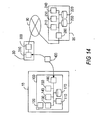
- Figure 15 is a diagram illustrating a specific modified example of the guiding images.
- image data generation module 240 when image data generation module 240 prepares the image data corresponding to the various guidance points after computing the route with route computing module 230 of service provider 20, it is preferred that the images be generated superimposed on the map image information at the same time.
- the following scheme is preferred for the display image shown in Figure 15D: after the route is computed by route computing module 230 of service provider 20, the image data corresponding to each guidance point is prepared with image data generation module 240; in this case, the text information of "turn left at intersection **" is attached to the image file, and when it is displayed on information terminal 100 by display image generation module 130, this text guide information is superimposed and displayed on the image.
- the guidance of vehicle 10 to the destination by navigation system 1 is not limited to visual means with an image being displayed on display module 120.
- information terminal 100 has an audio player, and the text guidance information explained with reference to Figure 15D is output as a voice using the audio player.
- the driver of vehicle 10 can be guided with an even better understanding of the guidance information.
- information terminal 100 When audio output is performed by information terminal 100, the following scheme can also be adopted: information terminal 100 has a voice synthesizer, and the text guidance information transferred as information appended to the image file can be read by the voice synthesis means.
- the route is computed by route computing module 230 of service provider 20 and the image data corresponding to each guidance point is formed by image data generation module 240; in this case, the text guide information of "turn left at ** intersection,” “turn right onto Interstate **,” “turn right at the intersection with a gas station,” etc., is voice-synthesized to form an audio file, and the obtained audio file is appended to the image file and transferred to information terminal 100. This audio file is reproduced at information terminal 100 to obtain a voice output.
- the distance is computed from the position information and the latitude and longitude information for the guidance point, the distance is displayed, and the distance information is read out as a synthetic voice.
- the information of the position of the central point of the image data latitude and longitude information is appended to the image data in the image file, and, the position of vehicle 10 is determined based on this information and the position of vehicle 10 determined by position information acquisition module 150.
- this position information may be any prescribed point on the image, not just the central point.
- the latitude and longitude information for the upper-left corner of the image can be used, or the latitude and longitude information of the upper-left corner and lower-right corner can also be used as the appended information.
Landscapes
- Engineering & Computer Science (AREA)
- Radar, Positioning & Navigation (AREA)
- Remote Sensing (AREA)
- Automation & Control Theory (AREA)
- Physics & Mathematics (AREA)
- General Physics & Mathematics (AREA)
- Navigation (AREA)
- Instructional Devices (AREA)
- Traffic Control Systems (AREA)
Applications Claiming Priority (1)
| Application Number | Priority Date | Filing Date | Title |
|---|---|---|---|
| JP2004381377A JP2006184256A (ja) | 2004-12-28 | 2004-12-28 | 案内システム、案内方法、案内システム用サーバー、案内システム用移動体端末装置、案内情報提供処理プログラム、及び、案内システム端末装置用プログラム |
Publications (2)
| Publication Number | Publication Date |
|---|---|
| EP1677078A2 true EP1677078A2 (fr) | 2006-07-05 |
| EP1677078A3 EP1677078A3 (fr) | 2009-08-19 |
Family
ID=36094046
Family Applications (1)
| Application Number | Title | Priority Date | Filing Date |
|---|---|---|---|
| EP05257900A Withdrawn EP1677078A3 (fr) | 2004-12-28 | 2005-12-21 | Système et procédé de navigation |
Country Status (3)
| Country | Link |
|---|---|
| US (1) | US7729854B2 (fr) |
| EP (1) | EP1677078A3 (fr) |
| JP (1) | JP2006184256A (fr) |
Cited By (1)
| Publication number | Priority date | Publication date | Assignee | Title |
|---|---|---|---|---|
| FR2910957A1 (fr) * | 2006-12-31 | 2008-07-04 | Michelin Soc Tech | Procede de navigation pour terminaux mobiles avec serveur centralise |
Families Citing this family (29)
| Publication number | Priority date | Publication date | Assignee | Title |
|---|---|---|---|---|
| US20080255759A1 (en) * | 2007-04-11 | 2008-10-16 | Fatdoor, Inc. | Travel arrangements through buddy lists in a geosocial environment |
| US8862385B2 (en) * | 2008-05-08 | 2014-10-14 | Microsoft Corporation | Providing augmented travel directions |
| US8849314B2 (en) * | 2009-04-29 | 2014-09-30 | Blackberry Limited | Systems and methods for location tracking notification |
| US8260546B2 (en) | 2009-12-14 | 2012-09-04 | At&T Mobility Ii Llc | Systems and methods for providing geographical information to a mobile communications device |
| WO2012090325A1 (fr) * | 2010-12-28 | 2012-07-05 | トヨタ自動車株式会社 | Appareil de navigation |
| US8700331B2 (en) | 2011-06-03 | 2014-04-15 | Apple Inc. | Systems and methods for printing maps and directions |
| US8983778B2 (en) | 2012-06-05 | 2015-03-17 | Apple Inc. | Generation of intersection information by a mapping service |
| US9418672B2 (en) | 2012-06-05 | 2016-08-16 | Apple Inc. | Navigation application with adaptive instruction text |
| US9146125B2 (en) | 2012-06-05 | 2015-09-29 | Apple Inc. | Navigation application with adaptive display of graphical directional indicators |
| US9159153B2 (en) | 2012-06-05 | 2015-10-13 | Apple Inc. | Method, system and apparatus for providing visual feedback of a map view change |
| US8965696B2 (en) | 2012-06-05 | 2015-02-24 | Apple Inc. | Providing navigation instructions while operating navigation application in background |
| US10176633B2 (en) | 2012-06-05 | 2019-01-08 | Apple Inc. | Integrated mapping and navigation application |
| US9182243B2 (en) | 2012-06-05 | 2015-11-10 | Apple Inc. | Navigation application |
| US9319831B2 (en) | 2012-06-05 | 2016-04-19 | Apple Inc. | Mapping application with automatic stepping capabilities |
| US9230556B2 (en) | 2012-06-05 | 2016-01-05 | Apple Inc. | Voice instructions during navigation |
| US9997069B2 (en) | 2012-06-05 | 2018-06-12 | Apple Inc. | Context-aware voice guidance |
| US9886794B2 (en) | 2012-06-05 | 2018-02-06 | Apple Inc. | Problem reporting in maps |
| US9482296B2 (en) | 2012-06-05 | 2016-11-01 | Apple Inc. | Rendering road signs during navigation |
| US9269178B2 (en) | 2012-06-05 | 2016-02-23 | Apple Inc. | Virtual camera for 3D maps |
| US10119831B2 (en) | 2012-06-10 | 2018-11-06 | Apple Inc. | Representing traffic along a route |
| US11935190B2 (en) | 2012-06-10 | 2024-03-19 | Apple Inc. | Representing traffic along a route |
| US9197861B2 (en) | 2012-11-15 | 2015-11-24 | Avo Usa Holding 2 Corporation | Multi-dimensional virtual beam detection for video analytics |
| US9631930B2 (en) | 2013-03-15 | 2017-04-25 | Apple Inc. | Warning for frequently traveled trips based on traffic |
| US20140365505A1 (en) | 2013-06-08 | 2014-12-11 | Apple Inc. | Harvesting Addresses |
| US9200915B2 (en) | 2013-06-08 | 2015-12-01 | Apple Inc. | Mapping application with several user interfaces |
| US9317813B2 (en) | 2013-03-15 | 2016-04-19 | Apple Inc. | Mobile device with predictive routing engine |
| CN105229421B (zh) * | 2013-05-24 | 2017-09-29 | 三菱电机株式会社 | 地图信息处理装置以及地图信息处理方法 |
| US9273980B2 (en) | 2013-06-09 | 2016-03-01 | Apple Inc. | Direction list |
| US9500494B2 (en) | 2013-06-09 | 2016-11-22 | Apple Inc. | Providing maneuver indicators on a map |
Citations (3)
| Publication number | Priority date | Publication date | Assignee | Title |
|---|---|---|---|---|
| US6249740B1 (en) | 1998-01-21 | 2001-06-19 | Kabushikikaisha Equos Research | Communications navigation system, and navigation base apparatus and vehicle navigation apparatus both used in the navigation system |
| JP2002318135A (ja) | 2001-02-14 | 2002-10-31 | Matsushita Electric Ind Co Ltd | 車載ナビゲーションシステム |
| EP1256785A2 (fr) | 2001-05-10 | 2002-11-13 | Navigation Technologies Corporation | Procédé et système pour fournir des instructions de route de secours avec un système de navigation |
Family Cites Families (12)
| Publication number | Priority date | Publication date | Assignee | Title |
|---|---|---|---|---|
| JP2989740B2 (ja) * | 1994-03-31 | 1999-12-13 | 富士通テン株式会社 | 経路案内方法 |
| JP3475123B2 (ja) * | 1999-05-24 | 2003-12-08 | アイシン・エィ・ダブリュ株式会社 | ナビゲーション装置および記憶媒体 |
| JP4239327B2 (ja) * | 1999-11-18 | 2009-03-18 | 株式会社エクォス・リサーチ | ナビゲーション方法 |
| DE10032921A1 (de) * | 2000-07-06 | 2002-01-24 | Bosch Gmbh Robert | Verfahren zur Ermittlung und Ausgabe von Fahrhinweisen |
| JP2002054936A (ja) * | 2000-08-11 | 2002-02-20 | Honda Motor Co Ltd | 自車両位置表示装置 |
| JP3452907B2 (ja) * | 2001-02-26 | 2003-10-06 | 株式会社ザナヴィ・インフォマティクス | 車載用ナビゲーション装置 |
| JP2003042772A (ja) * | 2001-07-31 | 2003-02-13 | Pioneer Electronic Corp | 通信ナビゲーションシステム、通信ナビゲーション方法、経路誘導情報送信装置および端末装置 |
| JP2003065783A (ja) * | 2001-08-27 | 2003-03-05 | Pioneer Electronic Corp | 通信ナビゲーションシステム及び方法、地図情報提供通信センタ装置、通信ナビゲーション端末並びにコンピュータプログラム |
| JP3798731B2 (ja) * | 2002-05-21 | 2006-07-19 | 株式会社ケンウッド | ナビゲーション装置、データ配信システム及びデータ配信方法 |
| JP4172213B2 (ja) * | 2002-06-27 | 2008-10-29 | アイシン・エィ・ダブリュ株式会社 | ナビゲーションシステム、ナビゲーション装置、探索情報出力方法及びプログラム |
| JP4077304B2 (ja) * | 2002-11-28 | 2008-04-16 | アルパイン株式会社 | ナビゲーション装置 |
| KR100648342B1 (ko) * | 2003-02-10 | 2006-11-23 | 엘지전자 주식회사 | 네비게이션 시스템 및 그 동작 방법 |
-
2004
- 2004-12-28 JP JP2004381377A patent/JP2006184256A/ja active Pending
-
2005
- 2005-12-21 EP EP05257900A patent/EP1677078A3/fr not_active Withdrawn
- 2005-12-22 US US11/316,113 patent/US7729854B2/en not_active Expired - Fee Related
Patent Citations (3)
| Publication number | Priority date | Publication date | Assignee | Title |
|---|---|---|---|---|
| US6249740B1 (en) | 1998-01-21 | 2001-06-19 | Kabushikikaisha Equos Research | Communications navigation system, and navigation base apparatus and vehicle navigation apparatus both used in the navigation system |
| JP2002318135A (ja) | 2001-02-14 | 2002-10-31 | Matsushita Electric Ind Co Ltd | 車載ナビゲーションシステム |
| EP1256785A2 (fr) | 2001-05-10 | 2002-11-13 | Navigation Technologies Corporation | Procédé et système pour fournir des instructions de route de secours avec un système de navigation |
Cited By (1)
| Publication number | Priority date | Publication date | Assignee | Title |
|---|---|---|---|---|
| FR2910957A1 (fr) * | 2006-12-31 | 2008-07-04 | Michelin Soc Tech | Procede de navigation pour terminaux mobiles avec serveur centralise |
Also Published As
| Publication number | Publication date |
|---|---|
| US20060142939A1 (en) | 2006-06-29 |
| JP2006184256A (ja) | 2006-07-13 |
| EP1677078A3 (fr) | 2009-08-19 |
| US7729854B2 (en) | 2010-06-01 |
Similar Documents
| Publication | Publication Date | Title |
|---|---|---|
| US7729854B2 (en) | System and method for navigation | |
| US5787382A (en) | Navigation apparatus for displaying a map by limit information | |
| US7406380B2 (en) | Navigation system | |
| US7369938B2 (en) | Navigation system having means for determining a route with optimized consumption | |
| EP1324007B1 (fr) | Dispositif et procédé pour sortir des informations routières et dispositif et procédé pour distribuer des informations routières | |
| EP1035531A2 (fr) | Système fournissant de l'information pour unités mobiles | |
| US20060149463A1 (en) | Route guide information delivery method, route guidance method, information terminal and information delivery center | |
| US20040044470A1 (en) | Method for route guidance, and terminal equipment and central apparatus for use therein | |
| JP2653282B2 (ja) | 車両用道路情報表示装置 | |
| US20030023372A1 (en) | Road instruction information system for vehicles | |
| JP4128444B2 (ja) | 車載ナビゲータにおける案内表示方法 | |
| JP4039968B2 (ja) | ナビゲーションシステム | |
| EP1734340A1 (fr) | Dispositif de navigation | |
| JPH09152354A (ja) | 車両用ナビゲーション装置 | |
| JP2002156239A (ja) | 車載用カーナビゲーション装置 | |
| JP4068637B2 (ja) | 地図表示システム、地図表示装置および地図表示方法 | |
| JP4365359B2 (ja) | ナビゲーションシステム、ナビゲーション装置およびナビゲーション装置における動作モード制御方法 | |
| JP2002358004A (ja) | 地図表示端末、地図表示システム | |
| US20060152386A1 (en) | Nagivation apparatus | |
| JP2003042785A (ja) | 通信型ナビゲーションの反転経路取得方法 | |
| JPH07318358A (ja) | 経路探索表示装置 | |
| JPH06174481A (ja) | バーコード表示体、並びにそれを利用した情報出力装置、ナビゲーション装置及び地図情報検索システム | |
| JP2000055677A (ja) | 車両間通信方式 | |
| JP2002286469A (ja) | 交通情報取得システム | |
| WO2006019003A1 (fr) | Dispositif de navigation |
Legal Events
| Date | Code | Title | Description |
|---|---|---|---|
| PUAI | Public reference made under article 153(3) epc to a published international application that has entered the european phase |
Free format text: ORIGINAL CODE: 0009012 |
|
| AK | Designated contracting states |
Kind code of ref document: A2 Designated state(s): AT BE BG CH CY CZ DE DK EE ES FI FR GB GR HU IE IS IT LI LT LU LV MC NL PL PT RO SE SI SK TR |
|
| AX | Request for extension of the european patent |
Extension state: AL BA HR MK YU |
|
| PUAL | Search report despatched |
Free format text: ORIGINAL CODE: 0009013 |
|
| AK | Designated contracting states |
Kind code of ref document: A3 Designated state(s): AT BE BG CH CY CZ DE DK EE ES FI FR GB GR HU IE IS IT LI LT LU LV MC NL PL PT RO SE SI SK TR |
|
| AX | Request for extension of the european patent |
Extension state: AL BA HR MK YU |
|
| RIC1 | Information provided on ipc code assigned before grant |
Ipc: G09B 29/10 20060101ALN20090713BHEP Ipc: G08G 1/0969 20060101ALI20090713BHEP Ipc: G01C 21/36 20060101AFI20060405BHEP |
|
| 17P | Request for examination filed |
Effective date: 20091002 |
|
| 17Q | First examination report despatched |
Effective date: 20091106 |
|
| AKX | Designation fees paid |
Designated state(s): DE FR GB |
|
| STAA | Information on the status of an ep patent application or granted ep patent |
Free format text: STATUS: THE APPLICATION IS DEEMED TO BE WITHDRAWN |
|
| 18D | Application deemed to be withdrawn |
Effective date: 20110507 |