EP1790948A2 - Système de guidage d'itinéraire et procédé de guidage d'itinéraire - Google Patents
Système de guidage d'itinéraire et procédé de guidage d'itinéraire Download PDFInfo
- Publication number
- EP1790948A2 EP1790948A2 EP06123248A EP06123248A EP1790948A2 EP 1790948 A2 EP1790948 A2 EP 1790948A2 EP 06123248 A EP06123248 A EP 06123248A EP 06123248 A EP06123248 A EP 06123248A EP 1790948 A2 EP1790948 A2 EP 1790948A2
- Authority
- EP
- European Patent Office
- Prior art keywords
- recommended lane
- guidance
- route
- intersection
- processing portion
- Prior art date
- Legal status (The legal status is an assumption and is not a legal conclusion. Google has not performed a legal analysis and makes no representation as to the accuracy of the status listed.)
- Withdrawn
Links
- 238000000034 method Methods 0.000 title claims description 4
- 238000012545 processing Methods 0.000 claims abstract description 132
- 238000001514 detection method Methods 0.000 claims abstract description 25
- 238000013500 data storage Methods 0.000 description 18
- 230000005540 biological transmission Effects 0.000 description 11
- 238000004891 communication Methods 0.000 description 11
- 238000010586 diagram Methods 0.000 description 8
- 230000015654 memory Effects 0.000 description 7
- 238000012544 monitoring process Methods 0.000 description 7
- 238000013459 approach Methods 0.000 description 4
- 230000003287 optical effect Effects 0.000 description 4
- 230000006870 function Effects 0.000 description 3
- 238000012986 modification Methods 0.000 description 2
- 230000004048 modification Effects 0.000 description 2
- 230000002194 synthesizing effect Effects 0.000 description 2
- 206010039203 Road traffic accident Diseases 0.000 description 1
- 230000007423 decrease Effects 0.000 description 1
- 230000000994 depressogenic effect Effects 0.000 description 1
- 230000004069 differentiation Effects 0.000 description 1
- 230000002250 progressing effect Effects 0.000 description 1
- 238000007670 refining Methods 0.000 description 1
- 230000001105 regulatory effect Effects 0.000 description 1
- 239000000523 sample Substances 0.000 description 1
- 230000003936 working memory Effects 0.000 description 1
Images


Classifications
-
- G—PHYSICS
- G01—MEASURING; TESTING
- G01C—MEASURING DISTANCES, LEVELS OR BEARINGS; SURVEYING; NAVIGATION; GYROSCOPIC INSTRUMENTS; PHOTOGRAMMETRY OR VIDEOGRAMMETRY
- G01C21/00—Navigation; Navigational instruments not provided for in groups G01C1/00 - G01C19/00
- G01C21/26—Navigation; Navigational instruments not provided for in groups G01C1/00 - G01C19/00 specially adapted for navigation in a road network
- G01C21/34—Route searching; Route guidance
- G01C21/36—Input/output arrangements for on-board computers
- G01C21/3626—Details of the output of route guidance instructions
- G01C21/3658—Lane guidance
-
- G—PHYSICS
- G01—MEASURING; TESTING
- G01C—MEASURING DISTANCES, LEVELS OR BEARINGS; SURVEYING; NAVIGATION; GYROSCOPIC INSTRUMENTS; PHOTOGRAMMETRY OR VIDEOGRAMMETRY
- G01C21/00—Navigation; Navigational instruments not provided for in groups G01C1/00 - G01C19/00
- G01C21/26—Navigation; Navigational instruments not provided for in groups G01C1/00 - G01C19/00 specially adapted for navigation in a road network
- G01C21/34—Route searching; Route guidance
- G01C21/36—Input/output arrangements for on-board computers
- G01C21/3626—Details of the output of route guidance instructions
- G01C21/3655—Timing of guidance instructions
Definitions
- the present invention relates to a route guidance system and a route guidance method.
- the current position of a vehicle that is a host vehicle is detected by a Global Positioning System (GPS) device, for example.
- Map data is read out from a data storage portion, and a map screen is formed on a display unit.
- the host vehicle position which indicates one's current position, a map of the area surrounding the host vehicle position, and the like are displayed on the map screen. Therefore, a driver, who is an operator, can drive the vehicle according to the host vehicle position that is displayed on the map screen.
- route search processing is executed based on the search conditions, and a route to the destination from a departure position, which is expressed as the current position, is sought according to the map data.
- a route that is specified that is, a specified route, is displayed on the map screen together with the host vehicle position.
- Guidance along the specified route, that is, route guidance, is executed. Therefore, the driver can drive the vehicle along the specified route that is displayed.
- route guidance when there is a prescribed point, such as an intersection, for example, where the vehicle must turn right or left, route guidance is executed, such as by voice output, for example, before the vehicle arrives at the intersection, that is, the guidance intersection that serves as a guidance point.
- route guidance is executed, such as by voice output, for example, before the vehicle arrives at the intersection, that is, the guidance intersection that serves as a guidance point.
- a plurality of route guidance points are set at locations at set distances before the guidance intersection along the specified route.
- route guidance with a content that is set in advance for each of the route guidance points is output by voice.
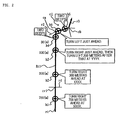
- FIG. 2 is a diagram showing an example of route guidance according to a conventional navigation system.
- the reference numerals r1 to r4 denote roads
- the reference numeral cr1 denotes an intersection of the roads r1 and r4
- the reference numeral c1 denotes a guidance intersection where the roads r1 and r2 intersect and the roads r2 and r3 intersect.
- the guidance intersection c1 includes successive intersections ca and cb.
- the roads r1 and r2 intersect at the intersection ca, and the roads r2 and r3 intersect at the intersection cb.
- the reference numeral Rt1 denotes the specified route.
- the specified route Rt1 is configured such that it passes along the roads r1 to r3 in that order and, at the guidance intersection c1, turns right at the intersection ca, then immediately turns left at the intersection cb.
- route guidance points h1 to h4 are set at locations 700 meters, 300 meters, 100 meters, and 30 meters before the guidance intersection c1, and route guidance points h5 and h6 are set between the intersections ca and cb on the road r2.
- a message such as "Turn right 700 meters ahead at XXXX,” or the like is output by voice at the route guidance point h1.
- a message such as “Turn right 300 meters ahead at XXXX,” or the like is output by voice at the route guidance point h2.
- a message such as "Turn right just ahead, then turn left 200 meters after that at YYYY,” or the like is output by voice at the route guidance point h3.
- a notification sound two beeps is output to indicate that the vehicle is about to enter the guidance intersection c1.
- a message such as "Turn left just ahead” or the like is output by voice at the route guidance point h5.
- a notification sound two beeps is output to indicate that the vehicle is about to enter the intersection cb.
- a prescribed lane is recommended as a preferable lane for driving, that is, as a recommended lane, and the vehicle is guided from the lane in which it is currently driving, that is, the driving lane, to the recommended lane.
- the conventional navigation system described above recommends a lane change after the vehicle has passed the point where the recommended lane changes, that is, the recommended lane change point. This confuses the driver.
- the present invention provides a route guidance system and a route guidance method that solve a problem of the conventional navigation system by not confusing the driver when guiding the driver to drive a host vehicle in a recommended lane.
- the route guidance system includes a current position detection portion that detects a current position of the host vehicle; a route search processing portion that searches for a specified route to a destination, based on the current position; a guidance intersection setting processing portion that sets a guidance intersection based on the specified route; a recommended lane computation processing portion that computes the recommended lane on each road on the specified route, based on the specified route; a recommended lane change point detection processing portion that detects a recommended lane change point, where the recommended lane changes, between the current position and the guidance intersection; and a recommended lane change notification processing portion that, before the host vehicle arrives at the recommended lane change point, notifies the driver that the recommended lane will change.
- the recommended lane change point where the recommended lane changes, is detected between the current position and the guidance intersection, and the driver is notified, before the host vehicle arrives at the recommended lane change point, that the recommended lane will change. Therefore, the driver is not confused when being guided to drive the host vehicle in the recommended lane.
- FIG. 1 is a diagram showing a navigation system according to the embodiment of the present invention.
- the reference numeral 10 denotes an automatic transmission control portion that serves as a power train control portion.
- the automatic transmission control portion 10 controls a power train that shifts gears at a prescribed gear ratio, such as a continuously variable transmission (CVT) that serves as an automatic transmission, a stepped transmission (automatic transmission), an electric drive unit, or the like.
- CVT continuously variable transmission
- stepped transmission automatic transmission
- electric drive unit or the like.
- the reference numeral 14 denotes a navigation unit that serves as an information terminal, such as an on-board unit that is mounted in a vehicle.
- the reference numeral 63 denotes a network
- the reference numeral 51 denotes an inform center that serves as an information provider.
- a navigation system is made up of the automatic transmission control portion 10, the navigation unit 14, the network 63, the information center 51, and the like.
- the navigation unit 14 includes a Global Positioning System (GPS) sensor 15, a data storage portion 16, a navigation processing portion 17, a direction sensor 18, an operation portion 34, a display portion 35, a voice input portion 36, a voice output portion 37, and a communications portion 38.
- GPS Global Positioning System
- the data storage portion 16 serves as an information storage portion where map data and various other types of data are stored.
- the navigation processing portion 17 carries out various types of computational processing, such as navigation processing and the like, based on information that is input.
- the direction sensor 18 serves as a direction detection portion that detects the vehicle's direction.
- the operation portion 34 serves as a first input portion, by operating which the driver, who is the operator, makes a prescribed input.
- the display portion 35 serves as a first output portion that uses images displayed on a screen not shown in FIG. 1 to express various types of information and notify the driver.
- the voice input portion 36 serves as a second input portion for making a prescribed input by voice.
- the voice output portion 37 serves as a second output portion that uses voice to express various types of information and notify the driver.
- the communications portion 38 serves as a transmitting and receiving portion that functions as a communications terminal.
- the GPS sensor 15, the data storage portion 16, the direction sensor 18, the operation portion 34, the display portion 35, the voice input portion 36, the voice output portion 37, and the communications portion 38 are connected to the navigation processing portion 17.
- the automatic transmission control portion 10 Also connected to the navigation processing portion 17 are the automatic transmission control portion 10, a forward monitoring unit 48, a rear view camera (rear monitoring camera) 49, an accelerator sensor 42, a brake sensor 43, a vehicle speed sensor 44, and the like.
- the forward monitoring unit 48 is installed at a prescribed location on the front end of the vehicle and monitors the area in front of the vehicle.
- the rear view camera 49 is installed at a prescribed location on the rear end of the vehicle and serves as a photography unit that captures images of the area behind the vehicle and as a rear monitoring unit.
- the accelerator sensor 42 serves as an engine load detection portion that detects the driver's operation of the accelerator pedal based on the accelerator angle.
- the brake sensor 43 serves as a braking detection portion that detects the driver's operation of the brake pedal based on the amount by which the pedal is depressed.
- the vehicle speed sensor 44 serves as a vehicle speed detection portion that detects the vehicle speed. Note that the accelerator sensor 42, the brake sensor 43, and the like make up an operation information detection portion that detects information on the operation of the vehicle by the driver.
- the GPS sensor 15 detects the vehicle's current position on the Earth, as well as the time, by receiving radio waves generated by a satellite.
- the GPS sensor 15 is used as the current position detection portion, but a distance sensor, a steering sensor, an altimeter, or the like not shown in FIG. 1 can also be used individually or in combination instead of the GPS sensor 15.
- a gyroscopic sensor, a geomagnetic sensor, or the like can be used as the direction sensor 18.
- the direction sensor 18, the vehicle speed sensor 44, and the like are installed, but where a GPS sensor having functions to detect the host vehicle direction, the vehicle speed, and the like is used, the direction sensor 18, the vehicle speed sensor 44, and the like are not necessary.
- the data storage portion 16 is provided with a map data base made up of map data files, and map data is stored in the map data base.
- the map data includes intersection data pertaining to intersections (branching points), node data pertaining to nodes, road data pertaining to road links, search data that is processed for searching, facilities data pertaining to facilities, and the like, as well as local feature data pertaining to local features.
- the local features are made up of displays installed or formed on the road to provide various kinds of driving-related information and guidance to drivers. These displays include marking lines, indicators, pedestrian crosswalks, manholes, traffic signals, and the like. Marking lines include stop lines to stop vehicles, lane demarcation lines that delineate the boundaries of lanes, demarcation lines that delineate parking spaces, and the like. Indicators include lane differentiation indicators in the form of arrows in each lane to indicate the direction of travel, and guidance indicators, such as the word "Stop” and the like, that warn of an approaching location where the vehicle must stop momentarily.
- the local feature data include position information, which describes the position of each feature in terms of coordinates and the like, and image information, which shows an image of each feature. Note that for locations where the vehicle must stop momentarily, the information includes places where vehicles enter main roads from side roads, crossings, intersections with flashing red lights, and so on.
- the road data pertaining to the lanes include lane data that serve as lane information, including the number of lanes, lane numbers that are assigned to each lane on a road, lane positions, traffic categories that express the direction of travel in each lane, and the like. Data are also stored in the data storage portion 16 in order for the voice output portion 37 to output prescribed information.
- a statistical data base made up of statistical data files and a driving history data base made up of driving history data files are also stored in the data storage portion 16.
- the statistical data in the statistical data files and the driving history data in the driving history data files are stored as actual results data.
- the statistical data is actual traffic information provided in the past, that is, historical information that describes a history.
- Traffic information provided in the past by traffic information centers and the like (not shown in FIG. 1) as information providers, such as the Vehicle Information and Communication System (VICS) center and the like, traffic census information, which is data on traffic volumes from traffic censuses provided by the Ministry of Land Infrastructure and Transport, and road timetable information and the like, also provided by the Ministry of Land Infrastructure and Transport, are used individually or in combination.
- the statistical data is created by refining the information as necessary, then carrying out statistical processing. Note that congestion forecasting information and the like for forecasting congestion and other purposes can be added.
- the data items in the statistical data are made up of link numbers for various road links, direction flags to indicate the direction of travel, information classifiers that show the type of information, degrees of congestion at specific times, link required times that describe the times required to travel on various road links at specific times, data on link required times averaged for each day of the week (for example, average time for Wednesday), and the like.
- the driving history data is made up of information collected by the information center 51 from a plurality of vehicles, i.e., the host vehicle and other vehicles, and represents actual driving records of vehicles traveling on roads where each vehicle has traveled. That is, it is actual history information that describes driving records, and based on the driving data, probe data is computed and accumulated.
- the data items in the driving history data are made up of link required times at specific times when vehicles traveled on each road link, degrees of congestion at specific times when vehicles traveled on each road link, and the like. Note that the driving history data can be added to the statistical data.
- the degree of congestion is used as a congestion indicator that expresses the scale of congestion. Congestion, crowding, and non-congestion are expressed separately.
- the data storage portion 16 includes a disk not shown in FIG. 1, such as a hard disk, a CD, a DVD, an optical disk, or the like.
- the data storage portion 16 also includes a read/write head or the like for reading and writing the various type of data. It is also possible to use a memory card or the like for the data storage portion 16. Note that an external storage device is formed by the various disks, the memory card, or the like.
- the map data base, the statistical data base, the driving history data base, and the like are installed in the data storage portion 16, but the map data base, the statistical data base, the driving history data base, and the like can also be installed in the information center 51.
- the navigation processing portion 17 includes a CPU 31, a RAM 32, a ROM 33, and a flash memory that is not shown in FIG. 1.
- the CPU 31 serves as a control device that controls the entire navigation unit 14 and as a computation device.
- the RAM 32 is used as working memory when the CPU 31 performs various types of computational processing.
- the ROM 33 contains a control program, as well as various types of programs that search for routes to destinations, execute route guidance, and so on.
- the flash memory is used to store various types of data, programs, and the like. Note that an internal storage device is formed by the RAM 32, the ROM 33, the flash memory, or the like.
- various types of programs can be stored in the ROM 33, and various types of data can be stored in the data storage portion 16, but programs, data, and the like can also be stored on a disk or the like.
- programs, data, and the like that are read from the disk or the like can be written to the flash memory.
- the programs, data, and the like can therefore be updated by replacing the disk or the like.
- the control programs, data, and the like of the automatic transmission control portion 10 can also be stored on the disk or the like.
- the programs, data, and the like can be received through the communications portion 38 and written to the flash memory in the navigation processing portion 17.
- the operation portion 34 executes such tasks as correcting the current position when the vehicle starts to move, inputting a departure point and a destination, inputting points to be passed, and operating the communications portion 38, all according to the driver's operations.
- the operation portion 34 can use a keyboard, mouse, or the like that is installed independently of the display portion 35.
- the operation portion 34 can also use a touch panel that is capable of executing prescribed input operations that are done by touching or clicking on an image operation portion, such as various types of keys, switches, buttons, and the like that are displayed as images on a screen that is formed by the display portion 35.
- the display portion 35 is used as a display.
- the various screens that are formed on the display portion 35 can display the vehicle's current position as the host vehicle's position; the vehicle's direction as the host vehicle's direction; maps, the specified route, guidance information along the specified route, traffic information, and the like; the distance to the next intersection on the specified route and the direction of travel at the next intersection.
- the screens can also display operation guidance, operation menus, and key guidance for the image operation portion, the operation portion 34, the voice input portion 36, and the like.
- the screens can also display programs and the like that are broadcast by FM multiplex.
- the voice input portion 36 includes a microphone that is not shown in FIG. 1 and can input required information by voice.
- the voice output portion 37 includes a voice synthesizing unit and a speaker, which are not shown in FIG. 1.
- the voice output portion 37 outputs the specified route, the guidance information, the traffic information, and the like by means of a voice that is synthesized by the voice synthesizing unit, for example.
- the communications portion 38 includes a beacon receiver and an FM receiver for receiving various types of the information, such as current traffic information that is transmitted from the traffic information center, general information, and the like.
- the beacon receiver receives the information as radio wave signals or optical signals via radio wave beacons or optical beacons installed along the road.
- the FM receiver receives the information as FM multiplex broadcasts via an FM broadcast station.
- the traffic information includes congestion information, regulatory information, parking space information, traffic accident information, service area congestion status information, and the like.
- the general information includes news, weather forecasts, and the like.
- the beacon receiver and the FM receiver are combined in a single VICS receiver, but they can also be installed separately.
- the traffic information contains an information classification that defines the type of information, a mesh number that specifies a mesh, a link number that specifies a road link connecting two points (e.g., two intersections) and also distinguishes between inbound and outbound halves of the road, and link information that constitutes the content of the information that is provided for the corresponding link number.
- the link information is made up of congestion leading edge data, which tells the distance from the start of the road link to the leading edge of the congestion; the degree of congestion; a congestion length, which tells the distance from the leading edge of the congestion to its trailing edge; the link required time, which tells the time required to travel the road link; and so on.
- the communications portion 38 can also receive map data, statistical data, driving history data, and the like, as well as various types of the information such as traffic information, general information, and the like, via the network 63.
- the information center 51 includes a server 53, a communications portion 57 connected to the server 53, a data base 58 that serves as an information storage portion, and so on.
- the server 53 includes a CPU 54, a RAM 55, and a ROM 56.
- the CPU 54 serves as a control device and as a computation device.
- the data base 58 stores the same sort of data that is stored in the data storage portion 16, such as map data statistical data, and driving history data, for example.
- the information center 51 can also provide in real time various types of the information, such as current traffic information that is transmitted from the traffic information center, general information, and the like, as well as driving history data that is collected from a plurality of vehicles (the host vehicle and other vehicles).
- the forward monitoring unit 48 is made up of a radar, such as a laser radar, a millimeter-wave radar, or the like, or an ultrasonic sensor or the like, or a combination of a radar or the like and an ultrasonic sensor or the like.
- the forward monitoring unit 48 monitors a vehicle that is traveling ahead of the host vehicle, that is, a vehicle ahead, and also monitors momentary stopping points, obstacles, and the like.
- the forward monitoring unit 48 also detects the relative speed, which is the vehicle speed relative to the vehicle ahead, the approach speed in relation to momentary stopping points, the approach speed in relation to obstacles, the distance to the vehicle ahead, the time to the vehicle ahead, and the like, all as information about the area around the host vehicle.
- the rear view camera 49 is made up of a CCD device and is mounted so that its optical axis tilts downward in order to monitor the area behind the vehicle.
- the subjects for image capture include a vehicle traveling behind the host vehicle, that is, a vehicle behind, buildings and other structures on the roadside, and the like.
- the rear view camera 49 generates image data of the photographed subjects and sends the data to the CPU 31.
- the CPU 31 reads the image data and executes image processing on the image data to recognize individual photographed subjects as recognized objects.
- a CCD device is used as the rear view camera 49, but a C-MOS device or the like can be used.
- the navigation system, the control portion 10, the navigation processing portion 17, the CPUs 31, 54, the server 53, and the like function as computers, independently or in combinations of two or more, and execute computational processing based on various types of programs, data, and the like.
- storage media are made up of the data storage portion 16, the RAMs 32, 55, the ROMs 33, 56, the data base 58, the flash memories, and the like.
- microprocessors or the like can be used as computation devices in place of the CPUs 31, 54.
- a navigation initialization processing portion (not shown in FIG. 1) of the CPU 31 executes navigation initialization processing, reads the current position of the host vehicle detected by the GPS sensor 15, reads the host vehicle direction detected by the direction sensor 18, and initializes various types of data.
- a matching processing portion (not shown in FIG. 1) of the CPU 31 executes matching processing and specifies the current position by judging on which road link the current position lies, based on the track of the current position that was read, the shapes and arrangement of the various road links that make up the roads in the vicinity of the current position, and so on.
- the matching processing portion further specifies the current position based on the positions of various local features that are photographed subjects photographed by the rear view camera 49.
- an image recognition processing portion of the CPU 31, not shown in FIG. 1 executes image recognition processing, reading in image data from the rear view camera 49 and recognizing a local feature in an image formed from the image data.
- a distance computation processing portion of the CPU 31, not shown in FIG. 1 executes distance computation processing, computing a distance La from the camera 49 to the actual local feature, based on the position of the local feature in the image.
- a current position specification processing portion of the matching processing portion executes current position specification processing, reading in the distance La and reading local feature data from the data storage portion 16 to obtain the coordinates of the local feature, then specifying the current position based on the coordinates and the distance La.
- the lane detection processing portion can detect the current driving lane by reading the sensor output from the geomagnetic sensor, judging whether or not a detected object consisting of a strongly magnetic object such as a manhole cover or the like is present in a given lane on the road, based on the sensor output, and then detecting the driving lane based on that judgment.
- the lane detection processing portion can also detect the current driving lane by using the highly accurate GPS sensor 15 to detect the current position with high accuracy, then detecting the lane based on the current position detection result.
- the lane detection processing portion can also detect the current driving lane by combining the geomagnetic sensor output, the current position, and the like at the same time that it executes image processing on image data of marking lines.
- a map display processing portion of the display processing portion executes map display processing, forming a map display screen on the display portion 35 that displays the current position as the host vehicle position and the vehicle direction as the host vehicle direction, while also displaying maps of the areas surrounding the map screen.
- the driver is able to drive the vehicle according to the map, the host vehicle position, and the host vehicle direction.
- a destination setting processing portion of the CPU 31, not shown in FIG. 1 executes destination setting processing and sets the destination. Note that the departure point can also be input and set as necessary. It is also possible to register a given location in advance, then set the registered location as the destination.
- a search condition setting processing portion of the CPU 31, not shown in FIG. 1 executes search condition setting processing and sets the search condition.
- a route search processing portion of the CPU 31, not shown in FIG. 1, executes route search processing.
- the route search processing portion reads the current position, the destination, the search condition, and the like, and reads search data and the like from the data storage portion 16. Based on the current position, the destination, and the search data, the route search processing portion searches for a route from the departure point, expressed as the current position, to the destination, according to the search condition.
- the route search processing portion outputs route data that describe the specified route.
- the specified route is the route for which the total of the link costs assigned to each road link is the lowest.
- route search processing can be executed at the information center 51.
- the CPU 31 transmits the current position, the destination, the search condition, and the like to the information center 51 via the network 63.
- a route search processing portion of the CPU 54 executes route search processing in the same manner as CPU 31.
- the route search processing portion reads search data from the data base 58 and based on the current position, the destination, and the search data, searches for a route from the departure point to the destination, according to the search condition.
- the route search processing portion outputs route data that describe the specified route.
- a transmission processing portion of the CPU 54 not shown in FIG. 1, executes transmission processing, transmitting the route data to the navigation unit 14 via the network 63.
- a guidance processing portion of the CPU 31, not shown in FIG. 1 executes guidance processing and provides route guidance.
- a route display processing portion of the guidance processing portion executes route display processing, reading the route data and displaying the specified route on the map screen according to the route data.
- a guidance intersection setting processing portion of the guidance processing portion executes guidance intersection setting processing.
- the guidance intersection setting processing portion determines, according to the route data, that is, based on the specified route, whether or not there is an intersection where the vehicle must turn right or left. If there is an intersection where the vehicle must turn right or left, the intersection is set as a guidance intersection.
- an enlarged guidance point map forming processing portion of the guidance processing portion executes enlarged guidance point map forming processing.
- the enlarged guidance point map forming processing portion forms an enlarged map of the guidance intersection, that is, an enlarged intersection map, as an enlarged guidance point map in a specified area of the map screen and uses the enlarged intersection map to provide route guidance.
- an enlarged guidance point map display point is set at a location that is a set distance before the guidance intersection (closer than the guidance intersection to the current position) along the specified route.
- intersections such as junctions and the like, where traffic merges or diverges, are also set as guidance intersections.
- lane guidance can be provided.
- a recommended lane computation processing portion of the CPU 31, not shown in FIG. 1 executes recommended lane computation processing, reading the specified route, as well as intersection data, lane information, and the like, then computing a recommended lane on each road on the specified route, based on the specified route, the intersection data, the lane information, and the like.
- a lane display processing portion of the guidance processing portion executes lane display processing, forming a lane guidance map in a specified area of the map screen, displaying the recommended lane in the lane guidance map, and guiding the vehicle from its current driving lane to the recommended lane.
- the enlarged guidance point map forming processing portion displays the recommended lane on the enlarged intersection map.
- a recommended lane change point detection processing portion of the guidance processing portion executes recommended lane change point detection processing, reading recommended lane information, judging whether or not the recommended lane will change during the interval from the current position to the guidance intersection, that is, during the interval when lane guidance is provided, and if the recommended lane will change, detecting the recommended lane change point. Also, a recommended lane change notification processing portion of the guidance processing portion executes recommended lane change notification processing, reading the recommended lane change point and notifying the driver, before the vehicle arrives at the recommended lane change point, that the recommended lane will change.
- a recommended lane change point notification point setting processing portion of the recommended lane change notification processing portion executes recommended lane change point notification point setting processing, setting a point at a specified distance before the recommended lane change point as the point for notifying the driver of the recommended lane change point, that is, as the recommended lane change point notification point.
- a voice output notification processing portion of the recommended lane change notification processing portion executes voice output notification processing, such that when the vehicle arrives at the recommended lane change point notification point, the system notifies the driver, by means of voice output from the voice output portion 37, that the recommended lane will change at the recommended lane change point.
- a route guidance point setting processing portion of the guidance processing portion executes route guidance point setting processing, setting one or more route guidance points, which in this embodiment is a plurality of route guidance points, at locations at set distances before the guidance intersection on the specified route.
- a voice output processing portion of the guidance processing portion executes voice output processing, outputting by voice from the voice output portion 37 route guidance for the guidance intersection with a content that is set in advance for each of the route guidance points.
- the enlarged guidance point map display point at which the enlarged guidance point map is displayed and one of the route guidance points, such as the first route guidance point, for example, can be set to the same point.
- the recommended lane change point is used as a reference point for computing the timing of the start of route guidance for the guidance intersection, that is, the guidance start timing, and for setting the first route guidance point.
- the system judges whether or not the vehicle has passed the recommended lane change point.
- a recommended lane change point passing guidance processing portion of the guidance processing portion executes recommended lane change point passing guidance processing, setting a point at a specified distance beyond the recommended lane change point as a recommended lane change point passing guidance point.
- the system notifies the driver that the vehicle has passed the recommended lane change point by providing guidance to the new recommended lane.
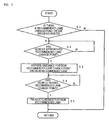
- FIG. 3 is a flowchart showing the operation of a route guidance processing portion according to the embodiment of the present invention.
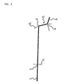
- FIG. 4 is a schematic diagram showing an example of the guidance intersection according to the embodiment of the present invention.
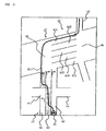
- FIG. 5 is a detailed drawing of the guidance intersection according to
- FIG. 6 is a diagram showing an example of lane guidance for the guidance intersection according to the embodiment of the present invention.
- the reference numerals r1 to r4 denote roads
- the reference numeral cr1 denotes an intersection of the roads r1 and r4
- the reference numeral c1 denotes a guidance intersection where the roads r1 and r2 intersect and the roads r2 and r3 intersect.
- the guidance intersection c1 includes successive intersections ca and cb.
- the roads r1 and r2 intersect at the intersection ca, and the roads r2 and r3 intersect at the intersection cb.
- the reference numeral Pr denotes the current position
- the reference numeral Rt1 denotes the specified route.
- the specified route Rt1 is configured such that it passes along the roads r1 to r3 in that order and, at the guidance intersection c1, turns right at the intersection ca, then immediately turns left at the intersection cb.
- Lanes k1 to k3 are formed on the road r1, and lanes k11 to k15 are formed on the road r2.
- the lane k1 is a left turn-only lane before the intersection cr1, but before the intersection ca of the guidance intersection c1
- the lane k1 is a lane where both right and left turns are possible.
- the lanes k2 and k3 are right turn-only lanes before the intersection ca of the guidance intersection c1.
- the lane k1 is a left turn-only lane before the intersection cr1, so the recommended lane computation processing portion makes the lane k2 the recommended lane in the lane guidance from the current position Pr to the intersection cr1.
- the lane k1 is a lane where a right turn is possible, and the lanes k2 and k3 are right turn-only lanes, but because the vehicle will turn left at the intersection cb, the recommended lane computation processing portion makes the lane k1 the recommended lane in the lane guidance from the intersection cr1 up to the intersection ca and makes the lane k11 the recommended lane in the lane guidance from the intersection ca to the intersection cb.
- the recommended lane change point detection processing portion reads the recommended lane information and detects the recommended lane change point on the specified route Rt1 to the intersection cb. On the specified route Rt1, the recommended lane changes from the lane k2 to the lane k1 at the intersection cr1, so the intersection cr1 is detected as the recommended lane change point. Note that it is actually not desirable for the lane to be changed within the intersection cr1, so the far-side edge of the intersection cr1 is set as the recommended lane change point. The near-side edge of the intersection cr1 can also be set as the recommended lane change point.
- the recommended lane change point notification point setting processing portion sets a point at a specified distance before the intersection cr1 as a recommended lane change point notification point ha.
- the voice output processing portion notifies the driver by voice output from the voice output portion 37 that the recommended lane will change from the lane k2 to the lane k1 at the intersection cr1.
- the route guidance point setting processing portion sets route guidance points h11 to h14 on the specified route Rt1 at locations 800 meters, 300 meters, 100 meters, and 30 meters before the guidance intersection c1, and sets route guidance points h15 and h16 between the intersections ca and cb on the road r2.
- the voice output processing portion outputs by voice from the voice output portion 37 route guidance for the guidance intersection c1 with a content that is set in advance for each of the route guidance points h11 to h16.
- the intersection cr1 is set as a recommended lane change point on the specified route Rt1 to the guidance intersection c1, so the intersection cr1 is used as a reference point for computing the guidance start timing for the guidance intersection c1, and for setting the first route guidance point h11 at 800 meters before the guidance intersection c1, so that the vehicle will be able to change to the new recommended lane k1 at the intersection cr1.
- the system judges whether or not the vehicle has passed the intersection cr1.
- the recommended lane change point passing guidance processing portion provides guidance to the new recommended lane at a recommended lane change point passing guidance point hb that is set on the guidance intersection c1 side of the intersection cr1.
- the middle lane is the recommended lane," or the like is output by voice at the route guidance point h11.
- a message such as "After the intersection, the recommended lane shifts one lane to the left,” or the like is output by voice at the recommended lane change point notification point ha.
- a message such as "The recommended lane is one lane to the left,” or the like is output by voice at the recommended lane change point passing guidance point hb, after the vehicle has passed the intersection cr1.
- a message such as "Turn right 300 meters ahead at XXXX,” or the like is output by voice at the route guidance point h12.
- a message such as "Turn right just ahead, then turn left 200 meters after that at YYYY,” or the like is output by voice at the route guidance point h13.
- a notification sound two beeps is output to indicate that the vehicle is about to enter the guidance intersection c1.
- a message such as "Turn left just ahead,” or the like is output by voice at the route guidance point h15.
- a notification sound two beeps is output to indicate that the vehicle is about to enter the intersection cb.
- the driver Because the driver is thus notified that the recommended lane will change, before the vehicle arrives at the recommended lane change point, the driver does not become confused. Also, because the driver can know the recommended lane change point and the new recommended lane as a result of the notification, it is not necessary for the driver to change lanes suddenly. Therefore, it is possible for the driver to drive the vehicle safely and smoothly.
- the timing of the start of route guidance for the guidance intersection can be optimized. Therefore, sufficient distance can be ensured from the current position to the recommended lane change point, so it is possible for the vehicle to change reliably to the new recommended lane at the recommended lane change point.
- a route guidance system includes a current position detection portion; a route search processing portion that searches for a specified route to a destination; a guidance intersection setting processing portion that sets a guidance intersection based on the specified route; a recommended lane computation processing portion that computes the recommended lane on each road on the specified route, based on the specified route; a recommended lane change point detection processing portion that detects a recommended lane change point, where a recommended lane changes, between the current position and the guidance intersection; and a recommended lane change notification processing portion that, before the host vehicle arrives at the recommended lane change point, notifies the driver that the recommended lane will change.
- the recommended lane change point is detected, and the driver is notified, before the host vehicle arrives at the recommended lane change point, that the recommended lane will change. Therefore, the driver is not confused when being guided to drive the host vehicle in the recommended lane.
Landscapes
- Engineering & Computer Science (AREA)
- Radar, Positioning & Navigation (AREA)
- Remote Sensing (AREA)
- Automation & Control Theory (AREA)
- Physics & Mathematics (AREA)
- General Physics & Mathematics (AREA)
- Navigation (AREA)
- Instructional Devices (AREA)
- Traffic Control Systems (AREA)
Applications Claiming Priority (1)
| Application Number | Priority Date | Filing Date | Title |
|---|---|---|---|
| JP2005317769A JP2007127419A (ja) | 2005-10-31 | 2005-10-31 | 経路案内システム及び経路案内方法 |
Publications (1)
| Publication Number | Publication Date |
|---|---|
| EP1790948A2 true EP1790948A2 (fr) | 2007-05-30 |
Family
ID=37949244
Family Applications (1)
| Application Number | Title | Priority Date | Filing Date |
|---|---|---|---|
| EP06123248A Withdrawn EP1790948A2 (fr) | 2005-10-31 | 2006-10-31 | Système de guidage d'itinéraire et procédé de guidage d'itinéraire |
Country Status (4)
| Country | Link |
|---|---|
| US (1) | US20070106460A1 (fr) |
| EP (1) | EP1790948A2 (fr) |
| JP (1) | JP2007127419A (fr) |
| CN (1) | CN1959347A (fr) |
Cited By (1)
| Publication number | Priority date | Publication date | Assignee | Title |
|---|---|---|---|---|
| US10205520B2 (en) | 2013-03-26 | 2019-02-12 | Accelink Technologies Co., Ltd. | Method and device for measuring optical signal-to-noise ratio |
Families Citing this family (36)
| Publication number | Priority date | Publication date | Assignee | Title |
|---|---|---|---|---|
| JP4771365B2 (ja) * | 2005-11-30 | 2011-09-14 | アイシン・エィ・ダブリュ株式会社 | 経路案内システム、経路案内方法及びプログラム |
| JP4335935B2 (ja) * | 2007-07-05 | 2009-09-30 | 本田技研工業株式会社 | ナビサーバ、ナビシステム |
| JP4446204B2 (ja) * | 2007-10-30 | 2010-04-07 | アイシン・エィ・ダブリュ株式会社 | 車両用ナビゲーション装置及び車両用ナビゲーションプログラム |
| JP4886044B2 (ja) * | 2008-01-29 | 2012-02-29 | パイオニア株式会社 | ナビゲーション装置、ナビゲーション方法、ナビゲーションプログラム、および記録媒体 |
| JP4905840B2 (ja) * | 2008-02-28 | 2012-03-28 | アイシン・エィ・ダブリュ株式会社 | ナビゲーション装置及びナビゲーションプログラム |
| WO2010075876A1 (fr) * | 2008-12-29 | 2010-07-08 | Tomtom International B.V. | Système de navigation avec des moyens destinés à indiquer la position latérale |
| WO2011026530A1 (fr) * | 2009-09-07 | 2011-03-10 | Tomtom International B.V. | Appareil de navigation et procédé de support d'une communication vocale main libre |
| DE102010029822A1 (de) | 2010-06-08 | 2011-12-08 | Bayerische Motoren Werke Aktiengesellschaft | Kraftfahrzeug mit einem Navigationssystem |
| JP5569365B2 (ja) * | 2010-11-30 | 2014-08-13 | アイシン・エィ・ダブリュ株式会社 | 案内装置、案内方法、及び案内プログラム |
| WO2013069060A1 (fr) * | 2011-11-10 | 2013-05-16 | 三菱電機株式会社 | Dispositif et procédé de navigation |
| CN103292816B (zh) * | 2012-02-23 | 2016-08-03 | 北京四维图新科技股份有限公司 | 电子地图生成方法、装置及路径规划方法、装置 |
| US8712624B1 (en) * | 2012-04-06 | 2014-04-29 | Google Inc. | Positioning vehicles to improve quality of observations at intersections |
| DE102012213344B4 (de) * | 2012-07-30 | 2025-08-21 | Robert Bosch Gmbh | Verkehrszeichenerkennung |
| JP6018881B2 (ja) * | 2012-11-07 | 2016-11-02 | 株式会社日立製作所 | ナビゲーション装置、及びナビゲーション方法 |
| JP6160191B2 (ja) * | 2013-04-15 | 2017-07-12 | アイシン・エィ・ダブリュ株式会社 | 運転支援システム、方法およびプログラム |
| CN104101353B (zh) * | 2013-04-15 | 2017-09-29 | 北京四维图新科技股份有限公司 | 一种导航方法、装置和实时导航系统 |
| KR101500082B1 (ko) * | 2013-06-10 | 2015-03-18 | 현대자동차주식회사 | 주행차로 인식 장치 및 방법 |
| CN104422462A (zh) * | 2013-09-06 | 2015-03-18 | 上海博泰悦臻电子设备制造有限公司 | 一种车辆导航的方法、装置 |
| GB201318049D0 (en) | 2013-10-11 | 2013-11-27 | Tomtom Int Bv | Apparatus and methods of displaying navigation instructions |
| JP6408770B2 (ja) * | 2014-03-03 | 2018-10-17 | 株式会社ゼンリン | プローブ情報の収集方法、収集装置、そのプログラム、及び、旅行時間算出装置 |
| JP6325998B2 (ja) * | 2015-02-25 | 2018-05-16 | 株式会社トヨタマップマスター | 歩行者用ナビゲーション装置、歩行者用ナビゲーション方法、コンピュータプログラム及びコンピュータプログラムを記録した記録媒体 |
| WO2016189649A1 (fr) | 2015-05-26 | 2016-12-01 | 日産自動車株式会社 | Dispositif et procédé de réglage de position d'arrêt de véhicule |
| KR102196681B1 (ko) * | 2015-07-27 | 2020-12-30 | 닛산 지도우샤 가부시키가이샤 | 차선 표시 장치 및 차선 표시 방법 |
| US10325494B2 (en) * | 2015-07-27 | 2019-06-18 | Nissan Motor Co., Ltd. | Route guidance device and route guidance method |
| KR20170124816A (ko) | 2016-05-03 | 2017-11-13 | 현대자동차주식회사 | 차량 주행 상황을 고려한 경로 산출 장치 및 방법 |
| US20180012118A1 (en) * | 2016-07-06 | 2018-01-11 | Inthinc Technology Solutions, Inc. | Predictive visual and verbal mentoring |
| CN116465424A (zh) * | 2016-11-26 | 2023-07-21 | 星克跃尔株式会社 | 用于指引路线的装置、方法、计算机程序以及计算机可读记录介质 |
| JP6720066B2 (ja) * | 2016-11-29 | 2020-07-08 | アルパイン株式会社 | 誘導経路設定装置および誘導経路設定方法 |
| CN108204819B (zh) * | 2016-12-19 | 2020-10-30 | 北京四维图新科技股份有限公司 | 一种地图数据自动检测方法和装置、及混合导航系统 |
| CN108237542B (zh) * | 2017-12-26 | 2021-07-09 | 上海加硕医药科技有限公司 | 一种引导准确的引导服务机器人 |
| CN108253975B (zh) * | 2017-12-29 | 2022-01-14 | 驭势(上海)汽车科技有限公司 | 一种建立地图信息及车辆定位的方法与设备 |
| CN111780773A (zh) * | 2019-04-04 | 2020-10-16 | 北京嘀嘀无限科技发展有限公司 | 一种识别弯道的方法及其系统 |
| CN110442144A (zh) * | 2019-08-06 | 2019-11-12 | 厦门理工学院 | 基于Android的导游无人机系统及其工作方法 |
| JP7347522B2 (ja) * | 2019-09-27 | 2023-09-20 | 株式会社アイシン | 運転支援装置及びコンピュータプログラム |
| CN112325896B (zh) * | 2020-10-30 | 2023-03-14 | 上海商汤临港智能科技有限公司 | 导航方法、装置、智能行驶设备及存储介质 |
| CN115019531B (zh) * | 2022-05-31 | 2024-03-22 | 东风汽车有限公司东风日产乘用车公司 | 车辆控制方法和车辆 |
Family Cites Families (8)
| Publication number | Priority date | Publication date | Assignee | Title |
|---|---|---|---|---|
| JP3214181B2 (ja) * | 1993-09-14 | 2001-10-02 | トヨタ自動車株式会社 | 車載用ナビゲーション装置 |
| JPH0798233A (ja) * | 1993-09-28 | 1995-04-11 | Mazda Motor Corp | 自動車のナビゲーション装置 |
| US6317684B1 (en) * | 1999-12-22 | 2001-11-13 | At&T Wireless Services Inc. | Method and apparatus for navigation using a portable communication device |
| JP3967061B2 (ja) * | 2000-03-28 | 2007-08-29 | アルパイン株式会社 | ナビゲーション装置 |
| JP4380026B2 (ja) * | 2000-06-05 | 2009-12-09 | 株式会社デンソー | ナビゲーション装置及び記録媒体 |
| DE10146744A1 (de) * | 2001-09-22 | 2003-04-17 | Bosch Gmbh Robert | Verfahren und System zum Bereitstellen von Fahrspurempfehlungen |
| JP3966170B2 (ja) * | 2002-12-05 | 2007-08-29 | 株式会社デンソー | 運転支援装置 |
| JP3991946B2 (ja) * | 2003-07-16 | 2007-10-17 | 株式会社デンソー | 経路設定装置、車両用ナビゲーション装置及びプログラム |
-
2005
- 2005-10-31 JP JP2005317769A patent/JP2007127419A/ja active Pending
-
2006
- 2006-10-31 US US11/589,902 patent/US20070106460A1/en not_active Abandoned
- 2006-10-31 CN CN200610142915.1A patent/CN1959347A/zh active Pending
- 2006-10-31 EP EP06123248A patent/EP1790948A2/fr not_active Withdrawn
Cited By (1)
| Publication number | Priority date | Publication date | Assignee | Title |
|---|---|---|---|---|
| US10205520B2 (en) | 2013-03-26 | 2019-02-12 | Accelink Technologies Co., Ltd. | Method and device for measuring optical signal-to-noise ratio |
Also Published As
| Publication number | Publication date |
|---|---|
| US20070106460A1 (en) | 2007-05-10 |
| JP2007127419A (ja) | 2007-05-24 |
| CN1959347A (zh) | 2007-05-09 |
Similar Documents
| Publication | Publication Date | Title |
|---|---|---|
| EP1804025B1 (fr) | Système et procédé de guidage routier. | |
| EP1793204B1 (fr) | Dispositif et procédé pour fournir des indications de guidage de voie | |
| EP1790948A2 (fr) | Système de guidage d'itinéraire et procédé de guidage d'itinéraire | |
| EP1912043B1 (fr) | Système de guide routier et procédé de guide routier | |
| EP1780510B1 (fr) | Système de guidage d'itinéraire et procédé de guidage d'itinéraire | |
| EP1793205A1 (fr) | Système de guidage routier et procédé de guidage routier | |
| JP4470873B2 (ja) | 経路案内システム及び経路案内方法 | |
| EP1780508A1 (fr) | Système de guidage d'itinéraire et procédé de guidage d'itinéraire | |
| JP2007178358A (ja) | 経路案内システム及び経路案内方法 | |
| JP2006277546A (ja) | 情報提供システム及び情報提供方法 | |
| JP4591311B2 (ja) | 経路案内システム及び経路案内方法 | |
| JP4581674B2 (ja) | 経路案内システム及び経路案内方法 | |
| JP4586606B2 (ja) | 経路案内システム及び経路案内方法 | |
| JP2007274564A (ja) | キャリブレーション装置及びキャリブレーション方法 | |
| JP4591073B2 (ja) | 経路案内システム | |
| JP2005071298A (ja) | インターチェンジの渋滞情報提供システムおよびナビゲーション装置 | |
| JP4572822B2 (ja) | 経路案内システム及び経路案内方法 | |
| JP4572823B2 (ja) | 経路案内システム及び経路案内方法 | |
| JP2007178359A (ja) | 経路案内システム及び経路案内方法 | |
| JP2007271518A (ja) | 経路案内システム及び経路案内方法 | |
| JP2007178357A (ja) | 経路案内システム及び経路案内方法 | |
| JP2007271345A (ja) | 車両案内システム及び車両案内方法 | |
| JP2010217196A (ja) | 経路案内システム及び経路案内方法 | |
| JP2007127421A (ja) | 経路案内システム及び経路案内方法 |
Legal Events
| Date | Code | Title | Description |
|---|---|---|---|
| PUAI | Public reference made under article 153(3) epc to a published international application that has entered the european phase |
Free format text: ORIGINAL CODE: 0009012 |
|
| AK | Designated contracting states |
Kind code of ref document: A2 Designated state(s): AT BE BG CH CY CZ DE DK EE ES FI FR GB GR HU IE IS IT LI LT LU LV MC NL PL PT RO SE SI SK TR |
|
| AX | Request for extension of the european patent |
Extension state: AL BA HR MK YU |
|
| STAA | Information on the status of an ep patent application or granted ep patent |
Free format text: STATUS: THE APPLICATION HAS BEEN WITHDRAWN |
|
| 18W | Application withdrawn |
Effective date: 20091021 |