EP1904869B1 - Verfahren und einrichtung zur bestimmung der bodenposition eines mobilen objekts insbesondere eines flugzeugs an einem flughafen - Google Patents
Verfahren und einrichtung zur bestimmung der bodenposition eines mobilen objekts insbesondere eines flugzeugs an einem flughafen Download PDFInfo
- Publication number
- EP1904869B1 EP1904869B1 EP06778862A EP06778862A EP1904869B1 EP 1904869 B1 EP1904869 B1 EP 1904869B1 EP 06778862 A EP06778862 A EP 06778862A EP 06778862 A EP06778862 A EP 06778862A EP 1904869 B1 EP1904869 B1 EP 1904869B1
- Authority
- EP
- European Patent Office
- Prior art keywords
- craft
- inertial
- data
- mobile
- position data
- Prior art date
- Legal status (The legal status is an assumption and is not a legal conclusion. Google has not performed a legal analysis and makes no representation as to the accuracy of the status listed.)
- Not-in-force
Links
- 238000000034 method Methods 0.000 title claims description 16
- 238000006073 displacement reaction Methods 0.000 claims description 12
- 230000001133 acceleration Effects 0.000 claims description 7
- 230000014509 gene expression Effects 0.000 claims description 6
- 230000000737 periodic effect Effects 0.000 claims 2
- 230000005540 biological transmission Effects 0.000 description 22
- 238000004364 calculation method Methods 0.000 description 5
- 238000013213 extrapolation Methods 0.000 description 2
- 241001080024 Telles Species 0.000 description 1
- 238000012550 audit Methods 0.000 description 1
- 238000010586 diagram Methods 0.000 description 1
- 238000005070 sampling Methods 0.000 description 1
- 230000000007 visual effect Effects 0.000 description 1
Images

Classifications
-
- G—PHYSICS
- G01—MEASURING; TESTING
- G01S—RADIO DIRECTION-FINDING; RADIO NAVIGATION; DETERMINING DISTANCE OR VELOCITY BY USE OF RADIO WAVES; LOCATING OR PRESENCE-DETECTING BY USE OF THE REFLECTION OR RERADIATION OF RADIO WAVES; ANALOGOUS ARRANGEMENTS USING OTHER WAVES
- G01S19/00—Satellite radio beacon positioning systems; Determining position, velocity or attitude using signals transmitted by such systems
- G01S19/38—Determining a navigation solution using signals transmitted by a satellite radio beacon positioning system
- G01S19/39—Determining a navigation solution using signals transmitted by a satellite radio beacon positioning system the satellite radio beacon positioning system transmitting time-stamped messages, e.g. GPS [Global Positioning System], GLONASS [Global Orbiting Navigation Satellite System] or GALILEO
- G01S19/42—Determining position
- G01S19/48—Determining position by combining or switching between position solutions derived from the satellite radio beacon positioning system and position solutions derived from a further system
- G01S19/49—Determining position by combining or switching between position solutions derived from the satellite radio beacon positioning system and position solutions derived from a further system whereby the further system is an inertial position system, e.g. loosely-coupled
-
- G—PHYSICS
- G01—MEASURING; TESTING
- G01C—MEASURING DISTANCES, LEVELS OR BEARINGS; SURVEYING; NAVIGATION; GYROSCOPIC INSTRUMENTS; PHOTOGRAMMETRY OR VIDEOGRAMMETRY
- G01C21/00—Navigation; Navigational instruments not provided for in groups G01C1/00 - G01C19/00
- G01C21/10—Navigation; Navigational instruments not provided for in groups G01C1/00 - G01C19/00 by using measurements of speed or acceleration
- G01C21/12—Navigation; Navigational instruments not provided for in groups G01C1/00 - G01C19/00 by using measurements of speed or acceleration executed aboard the object being navigated; Dead reckoning
- G01C21/16—Navigation; Navigational instruments not provided for in groups G01C1/00 - G01C19/00 by using measurements of speed or acceleration executed aboard the object being navigated; Dead reckoning by integrating acceleration or speed, i.e. inertial navigation
- G01C21/183—Compensation of inertial measurements, e.g. for temperature effects
- G01C21/188—Compensation of inertial measurements, e.g. for temperature effects for accumulated errors, e.g. by coupling inertial systems with absolute positioning systems
Definitions
- the present invention relates to a method and a device for determining the ground position of a mobile, in particular an aircraft on an airport.
- a reception set is generally used which is associated with a satellite positioning system, notably of the GPS ("Global Positioning System") type, for example Navstar, Galileo, GNSS, GLONASS .
- This reception assembly comprises in the usual way a receiving antenna which is mounted on the roof of the aircraft, as well as a receiver which is connected to this antenna and which generates position data of the aircraft, from signals detected by said antenna.
- a positioning assembly delivers the position data, i.e. information on the position of the aircraft, for the purpose of navigation in flight only every second, which is insufficient for the needs of airport navigation, since such a frequency of delivery does not make it possible to restore satisfactorily the displacements from the plane.
- the present invention aims to overcome the aforementioned drawbacks. It relates to a method for determining, precisely and with a high refresh rate, the ground position of any mobile, and in particular of an aircraft which is located on an airport.
- the mobile position is determined at a frequency which is higher than the transmission frequency of the position data, which makes it possible in particular to satisfy the need for a high refresh rate of the position. of an airplane as part of an airport navigation.
- the present invention takes account of the fact that the position data (which are preferably data generated by a receiver which is mounted on the mobile and which cooperates with a usual satellite positioning system, for example of GPS type, are the data
- the position data are used to determine the position of the moving body each time they are transmitted (step A /), and to obtain location information. of the mobile between two successive transmissions of such position data, the inertial data are taken into account which are preferably data generated by an inertial unit of said mobile (step B /).
- the position of the mobile obtained from said inertial data is certainly less precise (in general) than that obtained from the position data, but it is transmitted at a much higher frequency and thus makes it possible to fill the absence of information between two position data transmissions.
- the present invention applies to any type of mobile moving on the ground and having any type of means that are likely to generate position data and inertial data.
- vx i and vy i are computed speeds which are scaled to the speed of a receiving antenna associated with the aforesaid receiver and used to generate the position data, at each transmission of said position data.
- said inertial data correspond directly to inertial speeds.
- said inertial data may also correspond to accelerations which are used to determine said inertial speeds. This allows in particular to increase the frequency of calculation of the position of the mobile, since the accelerations are delivered at a higher frequency than the inertial speeds. In this case, the accelerations are used to perform an inertial extrapolation between two successive information of inertial speed.
- This last embodiment makes it possible to monitor and, if necessary, to filter any position data errors of limited duration (predetermined limit).
- a map is displayed on a display screen illustrating the environment of the mobile (for example an airport card), which is provided with a symbol indicating the position of said mobile as as determined in steps A / and B / d).
- the present invention also relates to an on-board device for determining the ground position of any mobile, in particular an aircraft traveling on an airport.
- the device according to the invention comprises, in addition, fifth means for presenting, on a display screen, a card which illustrates the environment of the mobile and which is provided with a symbol indicating the mobile position as determined by said third and fourth means.
- the device 1 according to the invention and shown schematically in the figure is embedded on a mobile (not shown), in particular an aircraft, which moves on the ground, and is intended to determine the current ground position of said mobile, for example the position on an airport in the case of an airplane.
- Said device 1 further comprises means 6 which are connected via links 7 and 8 respectively to said means 4 and 5, and which receive the positions determined by these means 4 and 5 and shape them, the case appropriate, before transmitting them to display means 9.
- These display means 9 comprise at least one usual display screen 10 and are formed so as to present on this display screen 10 a not shown card, which illustrates the environment of the mobile and which is provided with a symbol indicating the current position of the mobile, as transmitted by said means 6. This current position is updated periodically on the display screen 10 at each new generation of a current position value.
- said map can be an airport map showing at least a part of the airport on which the aircraft is located and possibly moves, and said symbol is a symbol illustrating the position of said airplane on said airport.
- said means 4, 5 and 6 are grouped in a central unit 11 which is connected via links 12, 13 and 14 respectively to said means 2, to said means 3 and to said display means 9. .
- the device 1 determines the position of the mobile at a frequency which is higher than the transmission frequency (by the means 2) of the position data, which makes it possible in particular to satisfy the need for a high refresh rate of the position of an aircraft in the context of an airport navigation.
- the present invention takes account of the fact that the position data (which is data generated by the receiver means 2 which cooperates with a usual satellite positioning system) are the available data used which are the most accurate. Also, the device 1 takes into account these position data (through the means 4) to determine the position of the mobile every time they are issued. In addition, to obtain information on the position of the mobile between two successive transmissions of such position data, said device 1 takes into account (via means 5) the inertial data generated by the means 3. The position of the mobile obtained from said inertial data is certainly less precise (in general) than that obtained from the position data, but it is transmitted at a much higher frequency and thus makes it possible to fill the absence of information between two data transmissions position.
- the present invention applies to any type of mobile moving on the ground and having means 2, 3 (of any type) which are capable of generating position data and inertial data.
- a preferred application relates to an airport navigation aid for an aircraft of the aforementioned type.
- the means 5 thus perform an arithmetic average on two values of inertial speed- taken at the beginning and at the end of this time range ⁇ t .
- vx i and vy i are calculated speeds which are scaled to the speed of the receiving antenna 17 associated with the receiver 15 of said means 2 which is used to generate the position data. This registration is performed at each transmission of said position data.
- said inertial data correspond directly to inertial speeds Vx and Vy, which simplifies the calculation of the position of the mobile with the aid of the preceding expressions.
- said inertial data may also correspond to accelerations which are used to determine said inertial speeds Vx and Vy. This makes it possible in particular to increase the frequency of calculation of the position of the mobile, since in the usual way the accelerations are delivered (generally every 20 ms) at a higher frequency than the inertial speeds (delivered generally every 100 ms). In this case, the accelerations are used to perform an inertial extrapolation between two successive information of the inertial speed, which serves as a reference in turn for the registration of this sub-algorithm. The rest of the algorithm remains unchanged.
- This latter embodiment makes it possible to monitor and, where appropriate, to filter any position data errors of limited duration (predetermined limit).
- the receiver 15 is capable of providing usual values HDOP, HFOM and HIL which represent precision information and give real-time indications on the quality of the location information (data position) issued.
- the device 1 comprises, in addition, means 18 which are for example integrated in the central unit 11 and which receive precision information of the aforementioned type and determine a potential error of position of the mobile from of this precision information, combining them with the known accuracy of the map data used by the display means 9. Said means 18 can transmit this potential error to said display means 9 so that they highlight on said map, around the symbol illustrating the current position of the mobile, an area which illustrates said potential error of the mobile, that is to say an area in which the mobile is with a certain probability.
- means may be provided to warn the pilot (for example in the form of audible and / or visual alerts) of a risk of incoherence between the accuracy of the position of the mobile and the detail of the map.
- alerts can range from the simple message addressed to the driver to the prohibition to use certain display scales for the display means 9.
Landscapes
- Engineering & Computer Science (AREA)
- Radar, Positioning & Navigation (AREA)
- Remote Sensing (AREA)
- Physics & Mathematics (AREA)
- General Physics & Mathematics (AREA)
- Automation & Control Theory (AREA)
- Computer Networks & Wireless Communication (AREA)
- Position Fixing By Use Of Radio Waves (AREA)
- Navigation (AREA)
- Traffic Control Systems (AREA)
- Radar Systems Or Details Thereof (AREA)
Claims (12)
- Verfahren zum Bestimmen der Bodenposition eines Mobilelements, wobei bei diesem Verfahren periodisch gesendete Positionsdaten und Trägheitsdaten verwendet werden, wobei:A/ bei jeder Sendung von Positionsdaten diese Positionsdaten verwendet werden, um die Position des Mobilelements zu bestimmen; undB/ zwischen zwei aufeinanderfolgenden Sendungen von Positionsdaten die Trägheitsdaten berücksichtigt werden; und:a) der zeitliche Raum zwischen diesen beiden aufeinanderfolgenden Sendungen in eine Vielzahl von Zeitspannen gleicher Dauer, die durch Zwischenzeitpunkte begrenzt sind, unterteilt wird;b) zu jedem der Zwischenzeitpunkte eine Trägheitsgeschwindigkeit des Mobilelements aus den entsprechenden Trägheitsdaten bestimmt wird; undd) für jeden Zwischenzeitpunkt die Position des Mobilelements anhand der Trägheitsdaten bestimmt wird,
dadurch gekennzeichnet, dass- zudem folgende Vorgänge durchgeführt werden:B/ c) für jede Zeitspanne der Mittelwert der Trägheitsgeschwindigkeiten der beiden Zwischenzeitpunkte, die diese Zeitspanne begrenzen, berechnet wird und daraus die Bewegung des Mobilelements am Boden während der Zeitspanne abgeleitet wird;- in Schritt d) für jeden Zwischenzeitpunkt die Position des Mobilelements aus seiner Position zu dem vorhergehenden Zwischenzeitpunkt und aus seiner Bewegung während der Zeitspanne, die durch diese beiden entsprechenden aktuellen und vorhergehenden Zwischenzeitpunkte begrenzt ist, bestimmt wird; und- in Schritt B/ c) und B/ d) die Position des Mobilelements anhand der folgenden Ausdrücke bestimmt wird:
wobei:- xi+1 und yi+1 die Koordinaten in einer waagerechten Ebene der Position des Mobilelements zu einem Zwischenzeitpunkt ti+1 sind;- x1 und y1 die Koordinaten in der waagerechten Ebene der Position des Mobilelements zu einem vorhergehenden Zwischenzeitpunkt ti sind;- Vxi+1 und Vyi+1 die Koordinaten in der waagerechten Ebene der Trägheitsgeschwindigkeit des Mobilelements zum Zwischenzeitpunkt ti+1 sind;- Vx und Vy die Koordinaten in der waagerechten Ebene der Trägheitsgeschwindigkeit des Mobilelements zum Zwischenzeitpunkt ti sind;- dt die Dauer der Zeitspanne ist; und- vxi und vyi berechnete Geschwindigkeiten sind, die auf die Geschwindigkeit einer Empfangsantenne (17) eingestellt sind, die verwendet wird, um die Positionsdaten zu erzeugen, bei jeder Sendung der Positionsdaten. - Verfahren nach Anspruch 1, dadurch gekennzeichnet, dass die Trägheitsdaten den Trägheitsgeschwindigkeiten direkt entsprechen.
- Verfahren nach Anspruch 1, dadurch gekennzeichnet, dass die Trägheitsdaten Beschleunigungen entsprechen, die es ermöglichen, die Trägheitsgeschwindigkeiten zu bestimmen.
- Verfahren nach einem der vorhergehenden Ansprüche, dadurch gekennzeichnet, dass bei jeder Sendung von Positionsdaten:- gemäß Schritt B/ eine erste Position des Mobilelements aus den Trägheitsdaten bestimmt wird;- die Abweichung zwischen dieser ersten Position und einer zweiten Position, die anhand der gesendeten Positionsdaten erzielt wird, berechnet wird; und- als Position des Mobilelements Folgendes verwendet wird:die erste Position, wenn die somit berechnete Abweichung größer oder gleich einem ersten vorherbestimmten Wert ist und kleiner als ein zweiter vorherbestimmter Wert ist; unddie zweite Position, wenn die Abweichung kleiner als der erste vorherbestimmte Wert ist.
- Verfahren nach einem der vorhergehenden Ansprüche, dadurch gekennzeichnet, dass in einem folgenden Schritt C/ auf einem Visualisierungsbildschirm (10) eine Karte angezeigt wird, welche die Umgebung des Mobilelements abbildet und mit einem Symbol versehen ist, das die Position des Mobilelements angibt, wie sie in Schritt A/ und B/ d) bestimmt wurde.
- Verfahren nach Anspruch 5, dadurch gekennzeichnet, dass:- Präzisionsinformationen über die Präzision der Positionsdaten gesammelt werden;- ein möglicher Positionsfehler des Mobilelements aus diesen Präzisionsinformationen bestimmt wird; und- auf der Karte, um das Symbol herum, ein Bereich hervorgehoben wird, der den möglichen Positionsfehler des Mobilelements abbildet.
- Verfahren nach einem der vorhergehenden Ansprüche, dadurch gekennzeichnet, dass die Positionsdaten Daten sind, die von einem Empfänger (15) erzeugt werden, der auf dem Mobilelement montiert ist und der mit einem Satelliten-Positionsbestimmungssystem zusammenwirkt.
- Verfahren nach einem der vorhergehenden Ansprüche, dadurch gekennzeichnet, dass die Trägheitsdaten Daten sind, die von einer Trägheitszentrale (3) des Mobilelements erzeugt werden.
- Bordvorrichtung zum Bestimmen der Bodenposition eines Mobilelements, wobei die Vorrichtung (1) Folgendes umfasst:- erste Mittel (2) zum periodischen Senden von Positionsdaten;- zweite Mittel (3) zum Senden von Trägheitsdaten;- dritte Mittel (4), um bei jeder Sendung von Positionsdaten die Position des Mobilelements aus den Positionsdaten zu bestimmen; und- vierte Mittel (5), um die Position des Mobilelements aus den Trägheitsdaten zwischen zwei aufeinanderfolgenden Sendungen von Positionsdaten zu bestimmen, wobei der Zeitraum zwischen zwei aufeinanderfolgenden Sendungen in eine Vielzahl von Zeitspannen gleicher Dauer, die durch Zwischenzeitpunkte begrenzt sind, unterteilt ist, wobei die vierten Mittel (5) Mittel umfassen, um zu jedem der Zwischenzeitpunkte eine Trägheitsgeschwindigkeit aus den entsprechenden Trägheitsdaten zu bestimmen,
dadurch gekennzeichnet, dass die vierten Mittel (5) zudem Folgendes umfassen:- Mittel, um für jede Zeitspanne den Mittelwert der Trägheitsgeschwindigkeiten der beiden Zwischenzeitpunkte, die diese Zeitspanne begrenzen, zu berechnen und um daraus die Bewegung des Mobilelements am Boden während der entsprechenden Zeitspanne abzuleiten; und- Mittel, um für jeden Zwischenzeitpunkt die Position des Mobilelements aus seiner Position zu dem vorhergehenden Zwischenzeitpunkt und aus seiner Bewegung während der Zeitspanne, die durch diese beiden entsprechenden, aktuellen und vorhergehenden Zwischenzeitpunkten begrenzt ist, anhand der folgenden Ausdrücke zu bestimmen: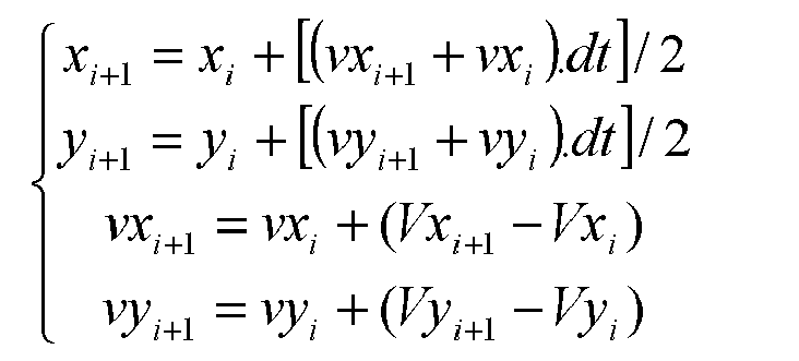
wobei:- xi+1 und yi+1 die Koordinaten in einer waagerechten Ebene der Position des Mobilelements zu einem Zwischenzeitpunkt ti+1 sind;- x1 und y1 die Koordinaten in der waagerechten Ebene der Position des Mobilelements zu einem vorhergehenden Zwischenzeitpunkt ti sind;- Vxi+1 und Vyi+1 die Koordinaten in der waagerechten Ebene der Trägheitsgeschwindigkeit des Mobilelements zum Zwischenzeitpunkt ti+1 sind;- Vx und Vy die Koordinaten in der waagerechten Ebene der Trägheitsgeschwindigkeit des Mobilelements zum Zwischenzeitpunkt ti sind;- dt die Dauer der Zeitspanne ist; und- vxi und vyi berechnete Geschwindigkeiten sind, die auf die Geschwindigkeit einer Empfangsantenne (17) eingestellt sind, die verwendet wird, um die Positionsdaten zu erzeugen, bei jeder Sendung der Positionsdaten. - Vorrichtung nach Anspruch 9, dadurch gekennzeichnet, dass sie zudem fünfte Mittel (9) umfasst, um auf einem Visualisierungsbildschirm (10) eine Karte vorzulegen, welche die Umgebung des Mobilelements abbildet und mit einem Symbol versehen ist, das die Position des Mobilelements angibt, wie sie durch die dritten und vierten Mittel (4, 5) bestimmt wurde.
- Vorrichtung nach einem der Ansprüche 9 und 10, dadurch gekennzeichnet, dass die ersten Mittel (2) einen Empfänger (15) umfassen, der auf dem Mobilelement montiert ist und mit einem Satelliten-Positionsbestimmungssystem zusammenwirkt.
- Vorrichtung nach einem der Ansprüche 9 bis 11, dadurch gekennzeichnet, dass die zweiten Mittel (3) mindestens eine Trägheitszentrale umfassen.
Applications Claiming Priority (2)
| Application Number | Priority Date | Filing Date | Title |
|---|---|---|---|
| FR0507567A FR2888643B1 (fr) | 2005-07-18 | 2005-07-18 | Procede et dispositif pour determiner la position au sol d'un mobile, particulier d'un avion sur un aeroport |
| PCT/FR2006/001692 WO2007010116A1 (fr) | 2005-07-18 | 2006-07-12 | Procede et dispositif pour determiner la position au sol d'un mobile, en particulier d'un avion sur un aeroport |
Publications (2)
| Publication Number | Publication Date |
|---|---|
| EP1904869A1 EP1904869A1 (de) | 2008-04-02 |
| EP1904869B1 true EP1904869B1 (de) | 2012-03-28 |
Family
ID=36169169
Family Applications (1)
| Application Number | Title | Priority Date | Filing Date |
|---|---|---|---|
| EP06778862A Not-in-force EP1904869B1 (de) | 2005-07-18 | 2006-07-12 | Verfahren und einrichtung zur bestimmung der bodenposition eines mobilen objekts insbesondere eines flugzeugs an einem flughafen |
Country Status (10)
| Country | Link |
|---|---|
| US (1) | US7848883B2 (de) |
| EP (1) | EP1904869B1 (de) |
| JP (1) | JP5249756B2 (de) |
| CN (1) | CN101223455B (de) |
| AT (1) | ATE551589T1 (de) |
| BR (1) | BRPI0616020A2 (de) |
| CA (1) | CA2615042C (de) |
| FR (1) | FR2888643B1 (de) |
| RU (1) | RU2380722C2 (de) |
| WO (1) | WO2007010116A1 (de) |
Families Citing this family (17)
| Publication number | Priority date | Publication date | Assignee | Title |
|---|---|---|---|---|
| US8446321B2 (en) | 1999-03-05 | 2013-05-21 | Omnipol A.S. | Deployable intelligence and tracking system for homeland security and search and rescue |
| US7889133B2 (en) | 1999-03-05 | 2011-02-15 | Itt Manufacturing Enterprises, Inc. | Multilateration enhancements for noise and operations management |
| US7612716B2 (en) | 1999-03-05 | 2009-11-03 | Era Systems Corporation | Correlation of flight track data with other data sources |
| US7739167B2 (en) | 1999-03-05 | 2010-06-15 | Era Systems Corporation | Automated management of airport revenues |
| US7908077B2 (en) | 2003-06-10 | 2011-03-15 | Itt Manufacturing Enterprises, Inc. | Land use compatibility planning software |
| US8203486B1 (en) | 1999-03-05 | 2012-06-19 | Omnipol A.S. | Transmitter independent techniques to extend the performance of passive coherent location |
| US7667647B2 (en) | 1999-03-05 | 2010-02-23 | Era Systems Corporation | Extension of aircraft tracking and positive identification from movement areas into non-movement areas |
| US7777675B2 (en) | 1999-03-05 | 2010-08-17 | Era Systems Corporation | Deployable passive broadband aircraft tracking |
| US7570214B2 (en) | 1999-03-05 | 2009-08-04 | Era Systems, Inc. | Method and apparatus for ADS-B validation, active and passive multilateration, and elliptical surviellance |
| US7782256B2 (en) | 1999-03-05 | 2010-08-24 | Era Systems Corporation | Enhanced passive coherent location techniques to track and identify UAVs, UCAVs, MAVs, and other objects |
| FR2888927B1 (fr) * | 2005-07-22 | 2008-03-07 | Airbus France Sas | Dispositif d'aide a la navigation au sol d'un avion sur un aeroport |
| US7965227B2 (en) | 2006-05-08 | 2011-06-21 | Era Systems, Inc. | Aircraft tracking using low cost tagging as a discriminator |
| FR2916060B1 (fr) | 2007-05-11 | 2009-07-10 | Airbus France Sa | Procede et dispositif de surveillance d'une position horizontale d'un avion roulant au sol. |
| FR2927455B1 (fr) * | 2008-02-08 | 2014-03-21 | Thales Sa | Procedes d'optimisation de la localisation d'un aeronef au sol et en phases de decollage et d'atterrissage |
| CN103900557B (zh) * | 2012-12-28 | 2017-11-03 | 联想(北京)有限公司 | 位置信息获取方法、装置和电子设备 |
| FR3002032B1 (fr) * | 2013-02-08 | 2016-02-12 | Dassault Aviat | Systeme et procede d'aide a la navigation d'un aeronef |
| FR3145217B1 (fr) * | 2023-01-25 | 2026-04-10 | Airbus Operations Sas | Systeme pour generer un signal d'anomalie au decollage a bord d’un d'aeronef |
Family Cites Families (22)
| Publication number | Priority date | Publication date | Assignee | Title |
|---|---|---|---|---|
| GB2229536B (en) * | 1989-03-22 | 1993-04-07 | Ferranti Int Signal | Signal processing apparatus and method |
| RU2108627C1 (ru) * | 1991-07-01 | 1998-04-10 | Ланс Хокан | Система индикации положения |
| FR2689668B1 (fr) * | 1992-04-07 | 1994-05-20 | Dassault Electronique | Procede et dispositif d'anti-collisions terrain pour aeronef. |
| US5539645A (en) * | 1993-11-19 | 1996-07-23 | Philips Electronics North America Corporation | Traffic monitoring system with reduced communications requirements |
| US5541845A (en) * | 1994-08-02 | 1996-07-30 | Trimble Navigation Limited | Monitoring of route and schedule adherence |
| JPH08304092A (ja) * | 1995-05-11 | 1996-11-22 | Nosakubutsu Seiiku Kanri Syst Kenkyusho:Kk | 移動体の位置検出方法と装置 |
| US5787384A (en) * | 1995-11-22 | 1998-07-28 | E-Systems, Inc. | Apparatus and method for determining velocity of a platform |
| JPH11118499A (ja) * | 1997-10-20 | 1999-04-30 | Churyo Eng Kk | 移動局の位置測定方法 |
| FR2773609B1 (fr) * | 1998-01-12 | 2000-02-11 | Dassault Electronique | Procede et dispositif d'anti-collision terrain pour aeronef, a visualisation perfectionnee |
| US6765531B2 (en) * | 1999-01-08 | 2004-07-20 | Trueposition, Inc. | System and method for interference cancellation in a location calculation, for use in a wireless location system |
| RU2160216C1 (ru) * | 1999-07-29 | 2000-12-10 | Карпов Анатолий Степанович | Способ определения положения осей координат инерциальной навигационной системы объекта относительно базовой системы координат (его варианты) |
| GB2373940A (en) * | 2001-03-27 | 2002-10-02 | Secr Defence | Locating the source of an unknown signal |
| FR2830320B1 (fr) * | 2001-09-28 | 2003-11-28 | Thales Sa | Centrale de navigation inertielle hybryde a integrite amelioree |
| US6789010B2 (en) * | 2001-12-04 | 2004-09-07 | Smiths Aerospace, Inc. | Airport map display system and data interchange method |
| US20040006424A1 (en) * | 2002-06-28 | 2004-01-08 | Joyce Glenn J. | Control system for tracking and targeting multiple autonomous objects |
| JP4262964B2 (ja) * | 2002-10-23 | 2009-05-13 | 中菱エンジニアリング株式会社 | 移動局の位置測定方法 |
| US6975959B2 (en) * | 2002-12-03 | 2005-12-13 | Robert Bosch Gmbh | Orientation and navigation for a mobile device using inertial sensors |
| US7490008B2 (en) * | 2004-09-17 | 2009-02-10 | Itt Manufacturing Enterprises, Inc. | GPS accumulated delta range processing for navigation applications |
| US7274504B2 (en) * | 2005-01-14 | 2007-09-25 | L-3 Communications Corporation | System and method for advanced tight coupling of GPS and inertial navigation sensors |
| US7477986B1 (en) * | 2005-03-01 | 2009-01-13 | Raytheon Company | Method and system for correction of navigational errors using general signals of opportunity |
| US20070004413A1 (en) * | 2005-06-29 | 2007-01-04 | Lucent Technologies Inc. | Network support for service denial based on speed of mobile station |
| FR2888927B1 (fr) * | 2005-07-22 | 2008-03-07 | Airbus France Sas | Dispositif d'aide a la navigation au sol d'un avion sur un aeroport |
-
2005
- 2005-07-18 FR FR0507567A patent/FR2888643B1/fr not_active Expired - Fee Related
-
2006
- 2006-07-12 WO PCT/FR2006/001692 patent/WO2007010116A1/fr not_active Ceased
- 2006-07-12 EP EP06778862A patent/EP1904869B1/de not_active Not-in-force
- 2006-07-12 US US11/994,987 patent/US7848883B2/en not_active Expired - Fee Related
- 2006-07-12 CN CN2006800261448A patent/CN101223455B/zh not_active Expired - Fee Related
- 2006-07-12 CA CA2615042A patent/CA2615042C/fr not_active Expired - Fee Related
- 2006-07-12 BR BRPI0616020-4A patent/BRPI0616020A2/pt not_active IP Right Cessation
- 2006-07-12 JP JP2008522005A patent/JP5249756B2/ja not_active Expired - Fee Related
- 2006-07-12 AT AT06778862T patent/ATE551589T1/de active
- 2006-07-12 RU RU2008105917/09A patent/RU2380722C2/ru not_active IP Right Cessation
Also Published As
| Publication number | Publication date |
|---|---|
| ATE551589T1 (de) | 2012-04-15 |
| JP2009501669A (ja) | 2009-01-22 |
| FR2888643B1 (fr) | 2009-09-25 |
| CN101223455B (zh) | 2012-06-13 |
| US20090128405A1 (en) | 2009-05-21 |
| JP5249756B2 (ja) | 2013-07-31 |
| BRPI0616020A2 (pt) | 2011-06-07 |
| CA2615042C (fr) | 2014-10-07 |
| RU2380722C2 (ru) | 2010-01-27 |
| US7848883B2 (en) | 2010-12-07 |
| WO2007010116A1 (fr) | 2007-01-25 |
| EP1904869A1 (de) | 2008-04-02 |
| CA2615042A1 (fr) | 2007-01-25 |
| RU2008105917A (ru) | 2009-08-27 |
| CN101223455A (zh) | 2008-07-16 |
| FR2888643A1 (fr) | 2007-01-19 |
Similar Documents
| Publication | Publication Date | Title |
|---|---|---|
| EP1904869B1 (de) | Verfahren und einrichtung zur bestimmung der bodenposition eines mobilen objekts insbesondere eines flugzeugs an einem flughafen | |
| EP0875002B1 (de) | Flugzeugsteuerhilfssystem mit head-up anzeigevorrichtung | |
| US9000979B2 (en) | Ephemeris extension method for GNSS applications | |
| EP0327447B1 (de) | Funknavigationssystem | |
| EP2353024B1 (de) | Verfahren zur lokalisierung eines objekts durch multitelemetrie | |
| EP1988408B1 (de) | Positionierungssystem, positionierungsverfahren und autonavigationssystem | |
| EP2267472A1 (de) | Ephemeriserweiterungsverfahren für GNSS-Anwendungen | |
| EP1876466B1 (de) | Vorrichtung zur Erstellung von Integritätsnachrichten, die nominelle, beschädigte oder inaktive Überwachungsstationen von Satellitennavigationssystemen melden | |
| EP2449409B1 (de) | Verfahren zur bestimmung der position eines mobilen körpers in einem bestimmten moment und zur überwachung der integrität der position des mobilen körpers | |
| EP3004912A1 (de) | Metrologieverfahren und vorrichtung zur kalibrierung der geometrie eines netzwerkes aus unterwasserakustikbaken | |
| EP2902797A1 (de) | Funkfrequenzverfahren und -system zur Bestimmung, durch den Drehmoment von Raumflugkörpern, der relativen Winkelposition von mehreren entfernten Raumflugkörpern | |
| EP2627970A1 (de) | Vorrichtung zur ortung eines fahrzeuges und verfahren zur erzeugung von fahrzeugortungsinformationen | |
| US7184887B2 (en) | Method and apparatus for calculating a figure of merit for GPS position using NMEA 0183 output | |
| FR2832796A1 (fr) | Centrale de navigation inertielle hybride a integrite amelioree en altitude | |
| EP1205732B1 (de) | Inertialnavigationseinheit mit integriertem GPS-Empfänger | |
| EP3353573B1 (de) | Verfahren und system zur bahnpositionierung | |
| WO2011039457A1 (fr) | Procédé et dispositif de localisation dynamique d'un mobile | |
| EP3724605A1 (de) | Verfahren zur schätzung von navigationsdaten eines landfahrzeugs unter verwendung von strassengeometrie- und -orientierungsparametern | |
| EP2366094B1 (de) | Verfahren mit druckhöhenkorrektur für ein flugzeug | |
| EP2626725B1 (de) | Bestimmungsverfahren einer Verlässlichkeitsanzeige in Bezug auf die eingeschlagene Bewegungsbahn eines mobilen Geräts | |
| EP2367025B1 (de) | Prüfungsverfahren und -system der Präzisionsleistungen eines satellitengesteuerten Navigationssystems | |
| WO2008152231A2 (fr) | Procédé et dispositif de surveillance d'une position horizontale d'un avion roulant au sol | |
| EP2259643B1 (de) | Verfahren zur Übertragung von Positionsinformationen über eine mobile Vorrichtung | |
| EP4184193B1 (de) | Verfahren zur bestimmung eines korrigierten abstandes | |
| EP2006707A1 (de) | Verfahren zur Ermittlung einer Schutzgrenze mit Kompensation von Berechnungsverzögerungen |
Legal Events
| Date | Code | Title | Description |
|---|---|---|---|
| PUAI | Public reference made under article 153(3) epc to a published international application that has entered the european phase |
Free format text: ORIGINAL CODE: 0009012 |
|
| 17P | Request for examination filed |
Effective date: 20071212 |
|
| AK | Designated contracting states |
Kind code of ref document: A1 Designated state(s): AT BE BG CH CY CZ DE DK EE ES FI FR GB GR HU IE IS IT LI LT LU LV MC NL PL PT RO SE SI SK TR |
|
| DAX | Request for extension of the european patent (deleted) | ||
| 17Q | First examination report despatched |
Effective date: 20090923 |
|
| RAP1 | Party data changed (applicant data changed or rights of an application transferred) |
Owner name: AIRBUS OPERATIONS |
|
| RAP1 | Party data changed (applicant data changed or rights of an application transferred) |
Owner name: AIRBUS OPERATIONS (SAS) |
|
| REG | Reference to a national code |
Ref country code: DE Ref legal event code: R079 Ref document number: 602006028488 Country of ref document: DE Free format text: PREVIOUS MAIN CLASS: G01S0005140000 Ipc: G01C0021280000 |
|
| GRAP | Despatch of communication of intention to grant a patent |
Free format text: ORIGINAL CODE: EPIDOSNIGR1 |
|
| RIC1 | Information provided on ipc code assigned before grant |
Ipc: G01C 21/28 20060101AFI20111017BHEP Ipc: G01C 21/16 20060101ALI20111017BHEP Ipc: G01S 19/49 20100101ALI20111017BHEP |
|
| DAX | Request for extension of the european patent (deleted) | ||
| GRAS | Grant fee paid |
Free format text: ORIGINAL CODE: EPIDOSNIGR3 |
|
| GRAA | (expected) grant |
Free format text: ORIGINAL CODE: 0009210 |
|
| AK | Designated contracting states |
Kind code of ref document: B1 Designated state(s): AT BE BG CH CY CZ DE DK EE ES FI FR GB GR HU IE IS IT LI LT LU LV MC NL PL PT RO SE SI SK TR |
|
| REG | Reference to a national code |
Ref country code: GB Ref legal event code: FG4D Free format text: NOT ENGLISH |
|
| REG | Reference to a national code |
Ref country code: CH Ref legal event code: EP |
|
| REG | Reference to a national code |
Ref country code: AT Ref legal event code: REF Ref document number: 551589 Country of ref document: AT Kind code of ref document: T Effective date: 20120415 |
|
| REG | Reference to a national code |
Ref country code: IE Ref legal event code: FG4D Free format text: LANGUAGE OF EP DOCUMENT: FRENCH |
|
| REG | Reference to a national code |
Ref country code: DE Ref legal event code: R096 Ref document number: 602006028488 Country of ref document: DE Effective date: 20120524 |
|
| REG | Reference to a national code |
Ref country code: NL Ref legal event code: VDEP Effective date: 20120328 |
|
| PG25 | Lapsed in a contracting state [announced via postgrant information from national office to epo] |
Ref country code: LT Free format text: LAPSE BECAUSE OF FAILURE TO SUBMIT A TRANSLATION OF THE DESCRIPTION OR TO PAY THE FEE WITHIN THE PRESCRIBED TIME-LIMIT Effective date: 20120328 |
|
| LTIE | Lt: invalidation of european patent or patent extension |
Effective date: 20120328 |
|
| PG25 | Lapsed in a contracting state [announced via postgrant information from national office to epo] |
Ref country code: FI Free format text: LAPSE BECAUSE OF FAILURE TO SUBMIT A TRANSLATION OF THE DESCRIPTION OR TO PAY THE FEE WITHIN THE PRESCRIBED TIME-LIMIT Effective date: 20120328 Ref country code: GR Free format text: LAPSE BECAUSE OF FAILURE TO SUBMIT A TRANSLATION OF THE DESCRIPTION OR TO PAY THE FEE WITHIN THE PRESCRIBED TIME-LIMIT Effective date: 20120629 Ref country code: LV Free format text: LAPSE BECAUSE OF FAILURE TO SUBMIT A TRANSLATION OF THE DESCRIPTION OR TO PAY THE FEE WITHIN THE PRESCRIBED TIME-LIMIT Effective date: 20120328 |
|
| REG | Reference to a national code |
Ref country code: AT Ref legal event code: MK05 Ref document number: 551589 Country of ref document: AT Kind code of ref document: T Effective date: 20120328 |
|
| PG25 | Lapsed in a contracting state [announced via postgrant information from national office to epo] |
Ref country code: CY Free format text: LAPSE BECAUSE OF FAILURE TO SUBMIT A TRANSLATION OF THE DESCRIPTION OR TO PAY THE FEE WITHIN THE PRESCRIBED TIME-LIMIT Effective date: 20120328 |
|
| PG25 | Lapsed in a contracting state [announced via postgrant information from national office to epo] |
Ref country code: EE Free format text: LAPSE BECAUSE OF FAILURE TO SUBMIT A TRANSLATION OF THE DESCRIPTION OR TO PAY THE FEE WITHIN THE PRESCRIBED TIME-LIMIT Effective date: 20120328 Ref country code: IS Free format text: LAPSE BECAUSE OF FAILURE TO SUBMIT A TRANSLATION OF THE DESCRIPTION OR TO PAY THE FEE WITHIN THE PRESCRIBED TIME-LIMIT Effective date: 20120728 Ref country code: CZ Free format text: LAPSE BECAUSE OF FAILURE TO SUBMIT A TRANSLATION OF THE DESCRIPTION OR TO PAY THE FEE WITHIN THE PRESCRIBED TIME-LIMIT Effective date: 20120328 Ref country code: RO Free format text: LAPSE BECAUSE OF FAILURE TO SUBMIT A TRANSLATION OF THE DESCRIPTION OR TO PAY THE FEE WITHIN THE PRESCRIBED TIME-LIMIT Effective date: 20120328 Ref country code: SI Free format text: LAPSE BECAUSE OF FAILURE TO SUBMIT A TRANSLATION OF THE DESCRIPTION OR TO PAY THE FEE WITHIN THE PRESCRIBED TIME-LIMIT Effective date: 20120328 Ref country code: SE Free format text: LAPSE BECAUSE OF FAILURE TO SUBMIT A TRANSLATION OF THE DESCRIPTION OR TO PAY THE FEE WITHIN THE PRESCRIBED TIME-LIMIT Effective date: 20120328 Ref country code: PL Free format text: LAPSE BECAUSE OF FAILURE TO SUBMIT A TRANSLATION OF THE DESCRIPTION OR TO PAY THE FEE WITHIN THE PRESCRIBED TIME-LIMIT Effective date: 20120328 |
|
| PG25 | Lapsed in a contracting state [announced via postgrant information from national office to epo] |
Ref country code: SK Free format text: LAPSE BECAUSE OF FAILURE TO SUBMIT A TRANSLATION OF THE DESCRIPTION OR TO PAY THE FEE WITHIN THE PRESCRIBED TIME-LIMIT Effective date: 20120328 Ref country code: PT Free format text: LAPSE BECAUSE OF FAILURE TO SUBMIT A TRANSLATION OF THE DESCRIPTION OR TO PAY THE FEE WITHIN THE PRESCRIBED TIME-LIMIT Effective date: 20120730 |
|
| BERE | Be: lapsed |
Owner name: AIRBUS OPERATIONS (SAS) Effective date: 20120731 |
|
| PG25 | Lapsed in a contracting state [announced via postgrant information from national office to epo] |
Ref country code: DK Free format text: LAPSE BECAUSE OF FAILURE TO SUBMIT A TRANSLATION OF THE DESCRIPTION OR TO PAY THE FEE WITHIN THE PRESCRIBED TIME-LIMIT Effective date: 20120328 Ref country code: NL Free format text: LAPSE BECAUSE OF FAILURE TO SUBMIT A TRANSLATION OF THE DESCRIPTION OR TO PAY THE FEE WITHIN THE PRESCRIBED TIME-LIMIT Effective date: 20120328 Ref country code: AT Free format text: LAPSE BECAUSE OF FAILURE TO SUBMIT A TRANSLATION OF THE DESCRIPTION OR TO PAY THE FEE WITHIN THE PRESCRIBED TIME-LIMIT Effective date: 20120328 |
|
| PLBE | No opposition filed within time limit |
Free format text: ORIGINAL CODE: 0009261 |
|
| STAA | Information on the status of an ep patent application or granted ep patent |
Free format text: STATUS: NO OPPOSITION FILED WITHIN TIME LIMIT |
|
| PG25 | Lapsed in a contracting state [announced via postgrant information from national office to epo] |
Ref country code: MC Free format text: LAPSE BECAUSE OF NON-PAYMENT OF DUE FEES Effective date: 20120731 |
|
| REG | Reference to a national code |
Ref country code: CH Ref legal event code: PL |
|
| 26N | No opposition filed |
Effective date: 20130103 |
|
| REG | Reference to a national code |
Ref country code: DE Ref legal event code: R097 Ref document number: 602006028488 Country of ref document: DE Effective date: 20130103 |
|
| PG25 | Lapsed in a contracting state [announced via postgrant information from national office to epo] |
Ref country code: CH Free format text: LAPSE BECAUSE OF NON-PAYMENT OF DUE FEES Effective date: 20120731 Ref country code: LI Free format text: LAPSE BECAUSE OF NON-PAYMENT OF DUE FEES Effective date: 20120731 Ref country code: ES Free format text: LAPSE BECAUSE OF FAILURE TO SUBMIT A TRANSLATION OF THE DESCRIPTION OR TO PAY THE FEE WITHIN THE PRESCRIBED TIME-LIMIT Effective date: 20120709 |
|
| REG | Reference to a national code |
Ref country code: IE Ref legal event code: MM4A |
|
| PG25 | Lapsed in a contracting state [announced via postgrant information from national office to epo] |
Ref country code: BE Free format text: LAPSE BECAUSE OF NON-PAYMENT OF DUE FEES Effective date: 20120731 |
|
| PG25 | Lapsed in a contracting state [announced via postgrant information from national office to epo] |
Ref country code: BG Free format text: LAPSE BECAUSE OF FAILURE TO SUBMIT A TRANSLATION OF THE DESCRIPTION OR TO PAY THE FEE WITHIN THE PRESCRIBED TIME-LIMIT Effective date: 20120628 Ref country code: IE Free format text: LAPSE BECAUSE OF NON-PAYMENT OF DUE FEES Effective date: 20120712 |
|
| PGFP | Annual fee paid to national office [announced via postgrant information from national office to epo] |
Ref country code: IT Payment date: 20130723 Year of fee payment: 8 |
|
| PG25 | Lapsed in a contracting state [announced via postgrant information from national office to epo] |
Ref country code: TR Free format text: LAPSE BECAUSE OF FAILURE TO SUBMIT A TRANSLATION OF THE DESCRIPTION OR TO PAY THE FEE WITHIN THE PRESCRIBED TIME-LIMIT Effective date: 20120328 |
|
| PG25 | Lapsed in a contracting state [announced via postgrant information from national office to epo] |
Ref country code: LU Free format text: LAPSE BECAUSE OF NON-PAYMENT OF DUE FEES Effective date: 20120712 |
|
| PG25 | Lapsed in a contracting state [announced via postgrant information from national office to epo] |
Ref country code: HU Free format text: LAPSE BECAUSE OF FAILURE TO SUBMIT A TRANSLATION OF THE DESCRIPTION OR TO PAY THE FEE WITHIN THE PRESCRIBED TIME-LIMIT Effective date: 20060712 |
|
| PG25 | Lapsed in a contracting state [announced via postgrant information from national office to epo] |
Ref country code: IT Free format text: LAPSE BECAUSE OF NON-PAYMENT OF DUE FEES Effective date: 20140712 |
|
| REG | Reference to a national code |
Ref country code: FR Ref legal event code: PLFP Year of fee payment: 10 |
|
| REG | Reference to a national code |
Ref country code: FR Ref legal event code: PLFP Year of fee payment: 11 |
|
| REG | Reference to a national code |
Ref country code: FR Ref legal event code: PLFP Year of fee payment: 12 |
|
| PGFP | Annual fee paid to national office [announced via postgrant information from national office to epo] |
Ref country code: FR Payment date: 20170724 Year of fee payment: 12 Ref country code: DE Payment date: 20170724 Year of fee payment: 12 Ref country code: GB Payment date: 20170719 Year of fee payment: 12 |
|
| REG | Reference to a national code |
Ref country code: DE Ref legal event code: R119 Ref document number: 602006028488 Country of ref document: DE |
|
| GBPC | Gb: european patent ceased through non-payment of renewal fee |
Effective date: 20180712 |
|
| PG25 | Lapsed in a contracting state [announced via postgrant information from national office to epo] |
Ref country code: FR Free format text: LAPSE BECAUSE OF NON-PAYMENT OF DUE FEES Effective date: 20180731 Ref country code: DE Free format text: LAPSE BECAUSE OF NON-PAYMENT OF DUE FEES Effective date: 20190201 Ref country code: GB Free format text: LAPSE BECAUSE OF NON-PAYMENT OF DUE FEES Effective date: 20180712 |