EP1926033A1 - Verfahren, Programm und Informatiksystem zur Fahrrinnen-Simulierung - Google Patents
Verfahren, Programm und Informatiksystem zur Fahrrinnen-Simulierung Download PDFInfo
- Publication number
- EP1926033A1 EP1926033A1 EP20070291383 EP07291383A EP1926033A1 EP 1926033 A1 EP1926033 A1 EP 1926033A1 EP 20070291383 EP20070291383 EP 20070291383 EP 07291383 A EP07291383 A EP 07291383A EP 1926033 A1 EP1926033 A1 EP 1926033A1
- Authority
- EP
- European Patent Office
- Prior art keywords
- channel
- axis
- final
- point
- data
- Prior art date
- Legal status (The legal status is an assumption and is not a legal conclusion. Google has not performed a legal analysis and makes no representation as to the accuracy of the status listed.)
- Ceased
Links
Images






Classifications
-
- G—PHYSICS
- G01—MEASURING; TESTING
- G01V—GEOPHYSICS; GRAVITATIONAL MEASUREMENTS; DETECTING MASSES OR OBJECTS; TAGS
- G01V20/00—Geomodelling in general
-
- G—PHYSICS
- G01—MEASURING; TESTING
- G01V—GEOPHYSICS; GRAVITATIONAL MEASUREMENTS; DETECTING MASSES OR OBJECTS; TAGS
- G01V1/00—Seismology; Seismic or acoustic prospecting or detecting
- G01V1/28—Processing seismic data, e.g. for interpretation or for event detection
- G01V1/30—Analysis
-
- G—PHYSICS
- G06—COMPUTING OR CALCULATING; COUNTING
- G06F—ELECTRIC DIGITAL DATA PROCESSING
- G06F30/00—Computer-aided design [CAD]
- G06F30/20—Design optimisation, verification or simulation
-
- G—PHYSICS
- G06—COMPUTING OR CALCULATING; COUNTING
- G06F—ELECTRIC DIGITAL DATA PROCESSING
- G06F2111/00—Details relating to CAD techniques
- G06F2111/08—Probabilistic or stochastic CAD
-
- Y—GENERAL TAGGING OF NEW TECHNOLOGICAL DEVELOPMENTS; GENERAL TAGGING OF CROSS-SECTIONAL TECHNOLOGIES SPANNING OVER SEVERAL SECTIONS OF THE IPC; TECHNICAL SUBJECTS COVERED BY FORMER USPC CROSS-REFERENCE ART COLLECTIONS [XRACs] AND DIGESTS
- Y10—TECHNICAL SUBJECTS COVERED BY FORMER USPC
- Y10T—TECHNICAL SUBJECTS COVERED BY FORMER US CLASSIFICATION
- Y10T137/00—Fluid handling
- Y10T137/8593—Systems
- Y10T137/86348—Tank with internally extending flow guide, pipe or conduit
Definitions
- the present invention relates to the simulation of channels by computer.
- Seismic waves can have natural (for example an earthquake) or artificial (eg explosives, vibratory truck, etc.) origins. Seismic reflection is distinguished from seismic refraction. Seismic reflection is used to determine the interfaces between geological levels.
- channels are of particular interest for oil exploration.
- a channel for example, is defined as a water pipe coming from the mainland, laden with sand or sediments, following a variable winding course along a sea slope.
- a marine flow path When a marine flow path is formed, it creates a channel that gradually fills with sediment carried by the liquid. These sediments are called turbidites.
- a new channel is created more or less displaced from the previous one. This is called channel migration.
- the succession of such sequences produces a channeling complex.
- the channeling complex represents a sediment transit path from the continental shelf to the deep basin. It shows an often erosive character and develops on the continental slope. It consists of an amalgam of individual turbiditic channels representing different phases and events of sediment transport.
- the channeling complexes has a geometrical shape characteristic of the stacking of the channels that constitute it.
- the sedimentary filling of the channeling complexes is distinct from that of its environment.
- the complex This channel has a relatively precise envelope and its border can be located. The edges of the channeling complex are then determinable from an isopaque map made between two seismic horizons defining the base of the complex and the top of the complex filling.
- the channeling complexes and more precisely the channels are potential oil reservoirs; they have the major characteristics such as porosity or high permeability.
- the channels are thus likely to contain oils that are desired to extract; it is therefore useful to model their training.
- Their sinuous geometry makes them difficult to simulate.
- pixel-based methods where the property is computed in each node (pixel) of a discrete model (a structured grid)
- object-based methods also called Boolean methods - where geological objects (channels, lobes, dunes, etc.) are constructed and then used to estimate the values of the property in the reservoir model.
- Pixel-based methods are not very suitable for channel simulation because they do not reproduce the curvilinear and continuous form of deposits, for example stream deposits.
- each geological object is defined as a more or less complex geometric form.
- the channels are defined from a sinuous curve whose distance to the channel axis is simulated according to a stochastic process. This simulated curve is used as the channel curve. The section of the channel is then calculated at every point of this curve, with generally a variable thickness and width. The results obtained are much less realistic than with deterministic methods. To solve this problem, it has been proposed to deform the curve obtained by using its geometry and an erosion-conforming law which is made on the convex edge of the channel. The results obtained are then more realistic and sinuous than the previous ones.
- EP-A-1,584,951 provides improvements to the known state of the art, by proposing a preliminary parameterization of a reference geological horizon H, with a view to stochastically generating paleo-channels or geological paleo-structures associated with the vicinity of this reference geological horizon.
- the object of the invention is thus to propose an automated simulation method, making it possible to simply obtain more realism with regard to the connectivity / continuity of the channels and, consequently, to improve the paths of development wells.
- This goal is achieved through a computer-implemented channel simulation method comprising steps for interpreting characteristic data of a final channel and a modeled initial channel; determining, from the interpreted data, points on trajectories ranging from the final channel to the initial channel; and simulating at least one intermediate channel passing through these points.
- the interpreted data are characteristic of respective axes of the final and initial channels, and in the step of determining the points, the points are determined on trajectories ranging from the final channel axis to the channel axis. initial.
- At the determining step at least one of the trajectories depends on a distance between a point of the axis of the final channel and a point of the axis of the initial channel.
- the point of the final channel axis is a characteristic point of a B-Spline curve adjusted to the final channel axis, the point the axis of the initial channel being a projection of this characteristic point on the axis of the initial channel, for example a perpendicular projection.
- said at least one of the trajectories is a line connecting the axis of the final channel and the axis of the initial channel, a curvature of which depends on said distance between the point of the channel axis. final and the point of the axis of the initial channel.
- the trajectory is a half parabola amplitude varying according to said distance between the point of the axis of the final channel and the point of the axis of the initial channel.
- the path is a straight line if the distance between the point of the final channel axis and the point of the original channel axis is greater than a critical distance; otherwise, the trajectory is a half parabola of amplitude varying according to the distance between the point of the axis of the final channel and the point of the axis of the initial channel.
- the critical distance is a calculated distance based on the interpreted data.
- the critical distance can be modified by the user.
- the method according to the invention further comprises, before the step of interpreting the data, the steps of: reading data relating to a channeling complex; and calculating the data characterizing the initial channel and / or the final channel from the data relating to the channeling complex.
- the data relating to the channeling complex characterize edges of said complex, and, at the step of calculating the data characterizing the initial channel and / or the final channel: the axis of the initial channel and / or the final channel is determined according to the edges of said complex.
- the calculated data characterize the initial channel, and, at the stage of calculating these data: the axis of the initial channel is the median of the edges of said complex.
- the calculated data characterize the final channel, and, at the step of calculating these data: the final channel axis is determined according to: the curvature of the edges of said complex, at characteristic points from each of these edges; and the sign of the curvature of these characteristic points.
- the invention also relates to a computer program product, the program comprising routines for executing the steps of the method according to the invention, when said program is executed on a computer.
- the invention also relates to a computer system comprising a memory containing a program comprising routines for executing the steps of the method according to the invention, when said program is executed.
- the figure 1 illustrates an interpretation of a seismic amplitude map in a channeling complex showing lateral migration.
- the lateral migration operates in a turbiditic context.
- the lateral migration constituting the turbiditic reservoirs is made by a succession of phases of erosion and partial filling of an elementary channel migrating over time. This migration is perpendicular to the direction of flow, but also longitudinally.
- the result is an organization called LOSC (Laterally Offset Stacked Channels), showing an evolution of the morphology of individual channels 1, 2, 3, 4 over time, from a sinuosity shape of accentuated, towards a final shape sweeping the channeling complex ( figure 1 ).
- the impenetrable barriers associated with the curbs of the channels are strongly preserved, being able in some cases to completely dissociate meander loops, trapping at the same time hydrocarbons.
- This case is illustrated on the figure 2 , which shows an interpretation in terms of reservoir facies of a seismic line in a channelization complex with lateral migration.
- references 21, 22 and 23 respectively denote: distal clays 21 (non-reservoir), channel sands 22 (reservoir) and impervious barriers 23.
- the second case (avulsion, reason 12 of the figure 1 ) is illustrated on the figure 3 , which shows an interpretation in terms of reservoir facies of a seismic line in a complex channeling with avulsion.
- References 31 and 32 respectively denote: distal clays 31 (non-reservoir) and channel sands 32 (reservoir).
- the impervious barriers are more weakly preserved; the dynamic behavior of the field is thus very different from the first case.
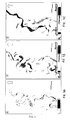
- FIGS. 4A - C show a seismic amplitude map ( Figure 4A ) and its interpretation in elementary channels ( Figure 4B ), the figure 4C showing the result of a "classical" geostatistical simulation of the channels of the Figure 4B .
- the method according to the invention is based on geometric laws resulting from the observation of the phenomenon on high resolution seismic data. These seismic data provide an outstanding quality image of the lateral migration phenomenon (corresponding to the Figure 4A ). It should be noted that to comply with the criteria for printing patent documents, the images on the Figures 4A - C had to be reworked; some details are therefore less visible than on color views.
- the invention provides a solution to this problem through simulation of one or more intermediate channels passing through points on trajectories from the final channel to the initial channel.
- the trajectories in question are distinguished from the axes or lines of channels; they reflect channel migration over time. Using these trajectories ensures a certain coherence in the arrangement of the simulated channels within the channeling complex. Starting from the final channel to arrive at the initial channel is also wise insofar as the information on the final channel is the most frequently observable or even quantifiable from the seismic data.
- the trajectories in question are therefore inverted with respect to the migration trajectories of the channels in time. Consequently, simulating an intermediate channel passing through points on these trajectories makes it possible to obtain more realism with regard to the connectivity / continuity of the channels.
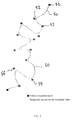
- FIG. figure 5 shows a B-Spline type curve modeling the central axis of the final channel; it further illustrates an extraction of characteristic points of this curve.
- the last channel which is visible or partially visible, can serve as a basis for the geometric construction of the other channels. We place our in a context where we have data characteristic of the final channel.
- the idea developed according to the invention is to return in the opposite direction in time, to the morphology of the initial channel, based for example on the overall morphology of the complex.
- the characteristic data of the complex will make it possible to obtain data characteristic of the initial channel modeled.
- the morphology of the channel then evolves between the final state and the initial state in a coherent manner and according to a number of finite states, where appropriate imposed by the user. These states actually reflect the number of distinct channels.
- the number of states thus makes it possible to fix the number of intermediate channels that one wishes to simulate. This number is for example deductible from experience. It may alternatively be contained or deductible from the data interpreted according to the method, for the purpose of the simulation.
- the step can then for example consist in applying a parameterized curve 50 on the axis (that is to say the central line) of the final channel pointed at the seismic.
- axis is meant an ideal (curved) line with respect to which the characteristic elements of a channel are arranged in a certain equilibrium.
- the axis once characterized, can then serve as a support for the trajectories from which the intermediate channels are simulated.
- the parameterized curve is a B-Spline.
- other types of representation such as polynomial representation or piecewise rational fractions, can be envisaged.
- Curve 50 although it corresponds to a final state, is the starting point of the approach used in the invention.
- final and initial channels it should be understood that a final channel is an elementary channel that has migrated over time relative to a particular initial channel. A final channel therefore corresponds to a state after the initial state.
- the end point (that is to say, corresponding to the initial state or the initial channel) is for example determined according to the morphology, typically the edges of the complex. This is illustrated on the figure 6 . To do this, a median curve 60 is extracted from the two edges 67, 68 of the channeling complex, whose characteristic data are available. This is easily generalized to three-dimensional data relating to the complex.
- the median curve 60 is for example treated in the same way as the curve 50, for example by applying a curve of B-Spline 60 type. and now data characteristic of the axis of the initial channel modeled 60, derived from the morphology of the complex. This will make it possible to determine points on trajectories ranging from the final channel to the initial channel, and more precisely from the axis of the final channel 50 to the axis of the initial channel 60.
- the trajectories are preferably modeled as being dependent on a distance between a point 52, 53, 55, 56 of the axis 50 of the final channel and a point of the axis 60 of the initial channel.
- the trajectories are thus easily parameterized according to the channel axes, which are representative of the final and initial channel geometry.
- the trajectories obtained are thus consistent with the morphology of the complex.
- the characteristic points 52, 53, 55, 56 of the final channel line 50 may for example be projected on the median curve 60 determined previously (as shown on the figure 6 ).
- the projection is typically a perpendicular projection.
- the Figures 7A - B illustrate the determination of trajectories based on a critical distance.
- the trajectories are preferably modeled as lines connecting the axis of the final channel 50 and the axis of the initial channel 60, a curvature of which depends on the previously determined projection distances.
- curvature of a trajectory we mean a quantitative measure of the more or less curved nature of this trajectory.
- the curvature can be zero ( Figure 7A ), in which case we obtain a line segment, or locally nonzero ( Figure 7B ), in which case a locally curved curve is obtained.
- the movement initiated on the characteristic points is for example carried out according to a half parabola 70, 80 ( Figure 7B ) whose focus is calculated relative to the point of origin 52, 53 on the axis of the final channel and whose orientation of the directrix is defined by the projection 52p, 53p of the point of origin on the median curve 60, that is to say the axis of the initial channel modeled ( Figure 7B ).
- the amplitude of the parabola is thus directly related to the morphology of the channeling complex. This helps to improve the realism of the simulated channels.
- the type of curve used varies according to the projection distance.
- a length or critical distance 75 (noted d on the figure 7 ) can be used to manage the type of curve used. This length is for example defined by the user or calculated according to the morphology of the complex according to a given model.
- the trajectory of the point is a straight line.
- the trajectory made by the control point is a half parabola whose amplitude is proportional to this distance carried along the line of projection then along the axis of the initial channel in the opposite direction to the flows ( Figure 7B ).
- the number of states (where appropriate user-configurable) is then used to extract points 71 - 74, 81 - 84 of these trajectories 70, 80, in order to subsequently associate them with respective channels.
- a random element of positioning of the points can be introduced through an area of uncertainty (if necessary also user-configurable).
- the centers of the areas in question may however be regularly distributed along the trajectories.
- the areas may partially overlap, as shown in the figure.
- the central lines of the intermediate channels are created by association of the points 71 - 74, 81 - 84 obtained in correspondence with each state (here four states 1-4 are represented). For example, a B-Spline adjusted to the points corresponding to a state is used for each of the states.
- the final morphology of the intermediate channels is then obtained by applying a morphology centered on each of the intermediate channel axes.
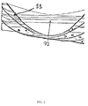
- the arrangement of intermediate channels 92B obtained is particularly realistic.
- the comparison with the figure 4C shows further that the implementation of the method according to the invention clearly improves the realism of the channels.
- the simulated channels according to the present invention provide a more realistic lateral connectivity.
- the approach adopted in the first embodiment must therefore be slightly modified: the final state must also be modeled in order to obtain characteristic data of the last channel. Once this data is available, the algorithm can proceed according to the first embodiment, described above.
- the modeling of the final channel is in this case also based on the morphology of the channeling complex. This is appropriate insofar as this morphology contains locally the information necessary for the reconstruction of the last channel, (in particular in meander loops).
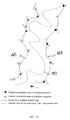
- the methodology adopted to create the last channel is based on previous methodology. This methodology is described with reference to the figure 10 , which illustrates the reconstruction of the final channel from the characteristic points of each of the edges of the complex.
- B-Spline curves are for example applied to each of the edges 167, 168 of the complex, to extract the characteristic points and the sign of curvature of each edge.
- the points numbered 1, 3, 6, 8, 9, 11 are points of the edge 167 with positive curvature (in the geometric sense).
- the points numbered 2, 4, 5, 7, 10, 12 are negative curvature points of the edge 168.
- the axis 150 of the final channel is for example determined according to the curvature and the sign of the curvature at characteristic points of the edges 167, 168.
- the user may designate a first control point on one of the edges of the complex.
- it is determined automatically, for example according to an order of appearance (this is in this case the point 1, the northernmost of the complex).
- all the control points 1, 3, 6, 8, 9, 11 having the same sign of curvature are then extracted, as well as the points 2, 4, 5, 7, 10, 12 of opposite sign controls on the edge of the opposite complex.
- a sorting on the sign of curvature associated with the characteristic points of each of the edges of the complex is thus operated.
- the curvature points retained "jump" from one edge to the other by changing the sign.
- These points are then assembled according to their respective order of appearance to allow to create an artificial final channel 150 by applying a B-Spline.
- the sorting thus made makes it possible to simply determine successive inflections of the curve 150 modeling the axis of the final channel, based on the morphology of the initial complex.
- the figure 11 allows to compare on an example a final channel 121A resulting from the seismic data ( figure 11A ) and the final channel 121B simulated from the morphology 101, 102 of the channeling complex, according to the present embodiment. As can be seen from the figure 11 the realism of the simulated final channel 121B is striking.
- the figure 12 allows comparison of interpreted channel maps 122A from the seismic data ( figure 12A ) with intermediate channel maps 122B simulated according to the first embodiment, from the final channel 121 B simulated as described above ( figure 12B ). Unlike the example associated with the previous embodiment, the channels 121A and 121B are no longer identical. However, again, the realism of the 122B channels is striking, although the final channel 121B has been simulated.
- the method according to the invention can moreover be implemented in a program and implemented by computer.
- the program in question can make the object of a module, which can in turn be inserted into another, more general program.
- the resulting module provides an opportunity for improved simulation of channels, particularly lateral migration channels, in turbidite reservoirs.
- Such a module makes it possible to overcome the lack of organization of the channels generated by geostatistical object simulation methods. This results in an optimal distribution of the barriers within the reservoir models in a channeling context.
- a direct impact of the implementation of the invention is a reduction of the costs related to the optimization of the trajectory of the development wells, and consequently a better exploitation of the oil traps in complex channeling.
- the method according to the invention can be an integral part of a development well trajectory optimization process. The increase in oil recovery can then reach 20% in some cases.
- data relating to an intermediate channel may optionally be integrated in the simulation so as to constrain this intermediate channel according to these data.
- the data relating to the final form of the complex, the data relating to the intermediate channel and the system evolution rules (on which the trajectories are based) are combined.
- an assistant of the module or program implementing the invention may propose to the user to simulate the final channel from the characteristics of the complex.
- this option can be applied by default, while remaining customizable by the user. If the user refuses this option, the algorithm proceeds according to the first embodiment. If, on the contrary, the user chooses this option, the algorithm then proceeds according to the second embodiment.
Landscapes
- Engineering & Computer Science (AREA)
- Physics & Mathematics (AREA)
- General Physics & Mathematics (AREA)
- Theoretical Computer Science (AREA)
- Life Sciences & Earth Sciences (AREA)
- General Life Sciences & Earth Sciences (AREA)
- Geophysics (AREA)
- Computer Hardware Design (AREA)
- Evolutionary Computation (AREA)
- Geometry (AREA)
- General Engineering & Computer Science (AREA)
- Remote Sensing (AREA)
- Geology (AREA)
- Environmental & Geological Engineering (AREA)
- Acoustics & Sound (AREA)
- Management, Administration, Business Operations System, And Electronic Commerce (AREA)
- Debugging And Monitoring (AREA)
- Test And Diagnosis Of Digital Computers (AREA)
- Geophysics And Detection Of Objects (AREA)
Applications Claiming Priority (1)
| Application Number | Priority Date | Filing Date | Title |
|---|---|---|---|
| FR0610259A FR2909200B1 (fr) | 2006-11-23 | 2006-11-23 | Procede, programme et systeme informatique de simulation de chenaux |
Publications (1)
| Publication Number | Publication Date |
|---|---|
| EP1926033A1 true EP1926033A1 (de) | 2008-05-28 |
Family
ID=38283061
Family Applications (1)
| Application Number | Title | Priority Date | Filing Date |
|---|---|---|---|
| EP20070291383 Ceased EP1926033A1 (de) | 2006-11-23 | 2007-11-21 | Verfahren, Programm und Informatiksystem zur Fahrrinnen-Simulierung |
Country Status (6)
| Country | Link |
|---|---|
| US (1) | US8019577B2 (de) |
| EP (1) | EP1926033A1 (de) |
| BR (1) | BRPI0711516A2 (de) |
| FR (1) | FR2909200B1 (de) |
| MX (1) | MX2007014668A (de) |
| NO (1) | NO340138B1 (de) |
Cited By (2)
| Publication number | Priority date | Publication date | Assignee | Title |
|---|---|---|---|---|
| FR3011962A1 (fr) * | 2013-10-14 | 2015-04-17 | Total Sa | Procede et dispositif pour la determination controlee de chenaux |
| CN117197220A (zh) * | 2023-09-07 | 2023-12-08 | 中国水产科学研究院长江水产研究所 | 一种自动生成河流断面及特征提取方法 |
Families Citing this family (12)
| Publication number | Priority date | Publication date | Assignee | Title |
|---|---|---|---|---|
| US9074454B2 (en) * | 2008-01-15 | 2015-07-07 | Schlumberger Technology Corporation | Dynamic reservoir engineering |
| CA2839857C (en) * | 2011-07-22 | 2016-06-21 | Landmark Graphics Corporation | Mapping geologic features |
| US10387583B2 (en) | 2011-12-02 | 2019-08-20 | Schlumberger Technology Corporation | Rotations from gradient directions |
| WO2013191693A1 (en) | 2012-06-21 | 2013-12-27 | Halliburton Energy Services, Inc. | Method and apparatus for formation tester data interpretation with diverse flow models |
| CN104453877B (zh) * | 2014-11-05 | 2018-05-15 | 长江大学 | 一种地下深埋曲流点坝砂体历史重建方法 |
| CN104375179B (zh) * | 2014-11-05 | 2017-02-15 | 中国石油天然气集团公司 | 基于trap‑3d软件寻找油气藏的方法 |
| RU2672766C1 (ru) * | 2018-02-08 | 2018-11-19 | Общество с ограниченной ответственностью "Газпромнефть Научно-Технический Центр" (ООО "Газпромнефть НТЦ") | СПОСОБ ПРОГНОЗИРОВАНИЯ МОРФОМЕТРИЧЕСКИХ ПАРАМЕТРОВ РУСЛОВЫХ ТЕЛ (палеоканалов) |
| WO2019243857A1 (en) * | 2018-06-20 | 2019-12-26 | Total Sa | Method for determination of subsoil composition |
| EP3819682B1 (de) * | 2019-11-08 | 2024-07-24 | TotalEnergies OneTech | Methode zur bestimmung einer realen geologischen formation mittels parametrischer flächen |
| CN116976112B (zh) * | 2023-08-01 | 2025-01-28 | 三峡大学 | 河道大断面数据提取方法、系统、电子设备及存储介质 |
| CN117766040B (zh) * | 2023-12-25 | 2025-01-17 | 长江大学 | 一种曲流河点坝泥质夹层的建模方法及装置 |
| CN118470098B (zh) * | 2024-07-11 | 2024-10-18 | 维飒科技(西安)有限公司 | 实现隧道三维点云中轴线智能纠偏方法及系统 |
Citations (1)
| Publication number | Priority date | Publication date | Assignee | Title |
|---|---|---|---|---|
| EP1584951A1 (de) | 2004-04-07 | 2005-10-12 | Earth Decision Sciences | Verfahren, Apparat und Computerprogramm zur stochastischen Simulation von Paleokanälen oder geologischen Paleostrukturen |
Family Cites Families (5)
| Publication number | Priority date | Publication date | Assignee | Title |
|---|---|---|---|---|
| US3662780A (en) * | 1967-10-31 | 1972-05-16 | Robert E Marsh | Fluid flow directing structure for pressure vessel |
| US5657223A (en) * | 1994-06-03 | 1997-08-12 | Exxon Production Research Company | Method for seismic data processing using depth slice decomposition |
| US7005301B2 (en) * | 2002-06-10 | 2006-02-28 | Sandia National Laboratories | Piecewise uniform conduction-like flow channels and method therefor |
| GB2396448B (en) * | 2002-12-21 | 2005-03-02 | Schlumberger Holdings | System and method for representing and processing and modeling subterranean surfaces |
| US7336078B1 (en) * | 2003-10-04 | 2008-02-26 | Seektech, Inc. | Multi-sensor mapping omnidirectional sonde and line locators |
-
2006
- 2006-11-23 FR FR0610259A patent/FR2909200B1/fr not_active Expired - Fee Related
-
2007
- 2007-11-19 US US11/942,058 patent/US8019577B2/en not_active Expired - Fee Related
- 2007-11-21 NO NO20075972A patent/NO340138B1/no not_active IP Right Cessation
- 2007-11-21 BR BRPI0711516-4A patent/BRPI0711516A2/pt not_active IP Right Cessation
- 2007-11-21 EP EP20070291383 patent/EP1926033A1/de not_active Ceased
- 2007-11-22 MX MX2007014668A patent/MX2007014668A/es active IP Right Grant
Patent Citations (1)
| Publication number | Priority date | Publication date | Assignee | Title |
|---|---|---|---|---|
| EP1584951A1 (de) | 2004-04-07 | 2005-10-12 | Earth Decision Sciences | Verfahren, Apparat und Computerprogramm zur stochastischen Simulation von Paleokanälen oder geologischen Paleostrukturen |
Non-Patent Citations (4)
| Title |
|---|
| L. HOLDEN, R.HAUGE, O. SKARE, A. SKORSTAD: "Modeling of Fluvial Reservoirs with Object Models", MATHEMATICAL GEOLOGY, vol. 30, no. 5, July 1998 (1998-07-01), pages 473 - 496, XP002444547 * |
| RAGNAR HAUGE ET AL: "Object Models with Vector Steering", MATHEMATICAL GEOLOGY, KLUWER ACADEMIC PUBLISHERS-PLENUM PUBLISHERS, NE, vol. 38, no. 1, 20 May 2006 (2006-05-20), pages 17 - 32, XP019403182, ISSN: 1573-8868 * |
| VISEUR S ET AL: "New fast, Stochastic, Boolean Simulation of Fluvial Deposits", SPE ANNUAL TECHNICAL CONFERENCE AND EXHIBITION, no. 49281, 27 September 1998 (1998-09-27), pages 697 - 709, XP002306772 * |
| VISEUR SOPHIE: "Stochastic Boolean simulation of fluvial deposits: a new approach combining accuracy with efficiency", PROC SPE ANNU TECH CONF EXHIB; PROCEEDINGS - SPE ANNUAL TECHNICAL CONFERENCE AND EXHIBITION 1999 SOC PET ENG (SPE), RICHARDSON, TX, USA, vol. 2 (PI), 1999, pages 227 - 234, XP002446402 * |
Cited By (5)
| Publication number | Priority date | Publication date | Assignee | Title |
|---|---|---|---|---|
| FR3011962A1 (fr) * | 2013-10-14 | 2015-04-17 | Total Sa | Procede et dispositif pour la determination controlee de chenaux |
| WO2015055904A1 (fr) * | 2013-10-14 | 2015-04-23 | Total Sa | Procédé et dispositif pour la détermination contrôlée de chenaux |
| AU2014336021B2 (en) * | 2013-10-14 | 2018-11-15 | Total Sa | Method and device for the controlled determination of channel waves |
| US10393922B2 (en) | 2013-10-14 | 2019-08-27 | Total Sa | Method and device for the controlled determination of channel waves |
| CN117197220A (zh) * | 2023-09-07 | 2023-12-08 | 中国水产科学研究院长江水产研究所 | 一种自动生成河流断面及特征提取方法 |
Also Published As
| Publication number | Publication date |
|---|---|
| FR2909200B1 (fr) | 2009-07-03 |
| BRPI0711516A2 (pt) | 2009-07-21 |
| US20080126048A1 (en) | 2008-05-29 |
| US8019577B2 (en) | 2011-09-13 |
| NO20075972L (no) | 2008-05-26 |
| MX2007014668A (es) | 2009-02-19 |
| NO340138B1 (no) | 2017-03-13 |
| FR2909200A1 (fr) | 2008-05-30 |
Similar Documents
| Publication | Publication Date | Title |
|---|---|---|
| EP1926033A1 (de) | Verfahren, Programm und Informatiksystem zur Fahrrinnen-Simulierung | |
| Natali et al. | Modeling Terrains and Subsurface Geology. | |
| EP1103921A1 (de) | Ein hybrides Rasterfeld geeignet zum Erstellen eines Modells einer heterogenen Anordnung gekreuzt durch ein oder mehrere Bohrlöcher | |
| CA2042067C (fr) | Procede de modelisation d'une surface et dispositif pour sa mise en oeuvre | |
| EP3023815B1 (de) | Konstruktionsverfahren eines geologischen modells | |
| EP1637904B1 (de) | Verfahren zur Erstellung eines Reservoirmodells mit einer flexiblen Gitterweite | |
| FR3039679A1 (fr) | Affectation de sequences sedimentaires | |
| FR3043227A1 (de) | ||
| FR2952210A1 (fr) | Methode pour la construction d'un espace de depot correspondant a un domaine geologique | |
| FR2755244A1 (fr) | Systeme de modelisation automatique de l'horizon base sur une surface de faille etendue de maniere non-artificielle | |
| EP1107187A1 (de) | Verfahren zur Generierung eines Netzes über einer heterogenen, von einer oder mehreren geometrischen Diskontinuitäten durchzogenen Formation mit dem Ziel der Realisierung von Simulationen | |
| CN102057373A (zh) | 虚拟石油系统 | |
| CN102057303A (zh) | 虚拟石油系统 | |
| FR2981475A1 (fr) | Methode pour construire un maillage d'un reservoir fracture avec un nombre limite de noeuds dans le milieu matrice | |
| FR3055723A1 (fr) | Modelisation basee sur un point-vecteur des proprietes de reservoir de petrole pour un modele de simulation de reservoir sans grille | |
| EP3523680B1 (de) | Verfahren zur herstellung eines geologischen vektormodells | |
| Miola et al. | A computational approach for 3D modeling and integration of heterogeneous geo-data | |
| EP2246714A2 (de) | Methode zur Modelldarstellung eines heterogenen unterirdischen Milieus auf der Basis einer Mehrpunktstatistik | |
| Viseur | Stochastic Boolean Simulation of Fluvial Deposits: A New Approach Combining Accuracy with Efficiency. | |
| FR2758397A1 (fr) | Procede et appareil pour determiner des relations geologiques entre des failles s'entrecroisant | |
| CN103543478A (zh) | 地质形态插值的km方法 | |
| Paris et al. | Authoring and simulating meandering rivers | |
| Pyrcz et al. | Event-based geostatistical modeling: application to deep-water systems | |
| EP2873989A1 (de) | Verfahren zum Erstellen eines repräsentativen Rasters einer physikalischen Eigentumsstreuung einer unterirdischen Formation durch bedingte statistische Mehrpunktsimulation | |
| Patel et al. | Modeling terrains and subsurface geology |
Legal Events
| Date | Code | Title | Description |
|---|---|---|---|
| PUAI | Public reference made under article 153(3) epc to a published international application that has entered the european phase |
Free format text: ORIGINAL CODE: 0009012 |
|
| AK | Designated contracting states |
Kind code of ref document: A1 Designated state(s): AT BE BG CH CY CZ DE DK EE ES FI FR GB GR HU IE IS IT LI LT LU LV MC MT NL PL PT RO SE SI SK TR |
|
| AX | Request for extension of the european patent |
Extension state: AL BA HR MK RS |
|
| 17P | Request for examination filed |
Effective date: 20081128 |
|
| 17Q | First examination report despatched |
Effective date: 20081230 |
|
| AKX | Designation fees paid |
Designated state(s): FR GB IT NL |
|
| REG | Reference to a national code |
Ref country code: DE Ref legal event code: 8566 |
|
| STAA | Information on the status of an ep patent application or granted ep patent |
Free format text: STATUS: EXAMINATION IS IN PROGRESS |
|
| RAP1 | Party data changed (applicant data changed or rights of an application transferred) |
Owner name: TOTAL SE |
|
| STAA | Information on the status of an ep patent application or granted ep patent |
Free format text: STATUS: THE APPLICATION HAS BEEN REFUSED |
|
| 18R | Application refused |
Effective date: 20201025 |