EP2005116B1 - Navigationsanordnung und navigationsverfahren für ein kraftfahrzeug - Google Patents
Navigationsanordnung und navigationsverfahren für ein kraftfahrzeug Download PDFInfo
- Publication number
- EP2005116B1 EP2005116B1 EP07723049.8A EP07723049A EP2005116B1 EP 2005116 B1 EP2005116 B1 EP 2005116B1 EP 07723049 A EP07723049 A EP 07723049A EP 2005116 B1 EP2005116 B1 EP 2005116B1
- Authority
- EP
- European Patent Office
- Prior art keywords
- motor vehicle
- route
- navigation system
- route proposal
- navigation
- Prior art date
- Legal status (The legal status is an assumption and is not a legal conclusion. Google has not performed a legal analysis and makes no representation as to the accuracy of the status listed.)
- Not-in-force
Links
- 238000000034 method Methods 0.000 title claims description 15
- 238000004891 communication Methods 0.000 claims description 41
- 230000005540 biological transmission Effects 0.000 claims description 8
- 235000004522 Pentaglottis sempervirens Nutrition 0.000 description 10
- 230000006870 function Effects 0.000 description 8
- 240000004050 Pentaglottis sempervirens Species 0.000 description 6
- 206010045178 Tunnel vision Diseases 0.000 description 6
- 230000007547 defect Effects 0.000 description 4
- 230000001419 dependent effect Effects 0.000 description 4
- 238000012790 confirmation Methods 0.000 description 3
- 238000010276 construction Methods 0.000 description 3
- 230000001413 cellular effect Effects 0.000 description 2
- 230000007613 environmental effect Effects 0.000 description 2
- 239000003550 marker Substances 0.000 description 2
- 230000008569 process Effects 0.000 description 2
- 230000001932 seasonal effect Effects 0.000 description 2
- 238000006243 chemical reaction Methods 0.000 description 1
- 238000002485 combustion reaction Methods 0.000 description 1
- 238000010586 diagram Methods 0.000 description 1
- 238000005516 engineering process Methods 0.000 description 1
- 230000004044 response Effects 0.000 description 1
- 230000007704 transition Effects 0.000 description 1
Images



Classifications
-
- G—PHYSICS
- G01—MEASURING; TESTING
- G01C—MEASURING DISTANCES, LEVELS OR BEARINGS; SURVEYING; NAVIGATION; GYROSCOPIC INSTRUMENTS; PHOTOGRAMMETRY OR VIDEOGRAMMETRY
- G01C21/00—Navigation; Navigational instruments not provided for in groups G01C1/00 - G01C19/00
- G01C21/26—Navigation; Navigational instruments not provided for in groups G01C1/00 - G01C19/00 specially adapted for navigation in a road network
- G01C21/34—Route searching; Route guidance
- G01C21/36—Input/output arrangements for on-board computers
- G01C21/3626—Details of the output of route guidance instructions
- G01C21/3635—Guidance using 3D or perspective road maps
-
- G—PHYSICS
- G01—MEASURING; TESTING
- G01C—MEASURING DISTANCES, LEVELS OR BEARINGS; SURVEYING; NAVIGATION; GYROSCOPIC INSTRUMENTS; PHOTOGRAMMETRY OR VIDEOGRAMMETRY
- G01C21/00—Navigation; Navigational instruments not provided for in groups G01C1/00 - G01C19/00
- G01C21/26—Navigation; Navigational instruments not provided for in groups G01C1/00 - G01C19/00 specially adapted for navigation in a road network
- G01C21/34—Route searching; Route guidance
- G01C21/36—Input/output arrangements for on-board computers
- G01C21/3626—Details of the output of route guidance instructions
- G01C21/3635—Guidance using 3D or perspective road maps
- G01C21/3638—Guidance using 3D or perspective road maps including 3D objects and buildings
-
- G—PHYSICS
- G01—MEASURING; TESTING
- G01C—MEASURING DISTANCES, LEVELS OR BEARINGS; SURVEYING; NAVIGATION; GYROSCOPIC INSTRUMENTS; PHOTOGRAMMETRY OR VIDEOGRAMMETRY
- G01C21/00—Navigation; Navigational instruments not provided for in groups G01C1/00 - G01C19/00
- G01C21/38—Electronic maps specially adapted for navigation; Updating thereof
- G01C21/3804—Creation or updating of map data
- G01C21/3833—Creation or updating of map data characterised by the source of data
- G01C21/3852—Data derived from aerial or satellite images
-
- G—PHYSICS
- G01—MEASURING; TESTING
- G01C—MEASURING DISTANCES, LEVELS OR BEARINGS; SURVEYING; NAVIGATION; GYROSCOPIC INSTRUMENTS; PHOTOGRAMMETRY OR VIDEOGRAMMETRY
- G01C21/00—Navigation; Navigational instruments not provided for in groups G01C1/00 - G01C19/00
- G01C21/38—Electronic maps specially adapted for navigation; Updating thereof
- G01C21/3885—Transmission of map data to client devices; Reception of map data by client devices
- G01C21/3889—Transmission of selected map data, e.g. depending on route
-
- G—PHYSICS
- G01—MEASURING; TESTING
- G01S—RADIO DIRECTION-FINDING; RADIO NAVIGATION; DETERMINING DISTANCE OR VELOCITY BY USE OF RADIO WAVES; LOCATING OR PRESENCE-DETECTING BY USE OF THE REFLECTION OR RERADIATION OF RADIO WAVES; ANALOGOUS ARRANGEMENTS USING OTHER WAVES
- G01S5/00—Position-fixing by co-ordinating two or more direction or position line determinations; Position-fixing by co-ordinating two or more distance determinations
- G01S5/0009—Transmission of position information to remote stations
-
- G—PHYSICS
- G01—MEASURING; TESTING
- G01S—RADIO DIRECTION-FINDING; RADIO NAVIGATION; DETERMINING DISTANCE OR VELOCITY BY USE OF RADIO WAVES; LOCATING OR PRESENCE-DETECTING BY USE OF THE REFLECTION OR RERADIATION OF RADIO WAVES; ANALOGOUS ARRANGEMENTS USING OTHER WAVES
- G01S5/00—Position-fixing by co-ordinating two or more direction or position line determinations; Position-fixing by co-ordinating two or more distance determinations
- G01S5/0009—Transmission of position information to remote stations
- G01S5/0045—Transmission from base station to mobile station
-
- G—PHYSICS
- G08—SIGNALLING
- G08G—TRAFFIC CONTROL SYSTEMS
- G08G1/00—Traffic control systems for road vehicles
- G08G1/09—Arrangements for giving variable traffic instructions
- G08G1/0962—Arrangements for giving variable traffic instructions having an indicator mounted inside the vehicle, e.g. giving voice messages
- G08G1/0968—Systems involving transmission of navigation instructions to the vehicle
- G08G1/0969—Systems involving transmission of navigation instructions to the vehicle having a display in the form of a map
Definitions
- the invention relates to a motor vehicle with a navigation system, wherein the navigation system comprises a location system for determining the position of the motor vehicle.
- the EP 0 875 730 B1 and the DE 698 15 940 T2 discloses a map information display apparatus for use in a car navigation apparatus having data conversion means for acquiring points of map data corresponding to a map from a viewpoint through a view line starting from the viewpoint and having a depth angle with respect to the plane of the map, and for perspective projecting the points of the map data to a viewing plane that is set perpendicular to the viewing line and has a predetermined distance from the viewpoint to generate map display data.
- a navigation system with a bird's eye view of an environment is also in the FR 2634707 as well as in the Magazine autoconnect 2005, United Motor-Verlag GmbH & Co. KG, Leuschnerstr. 1, 70174 Stuttgart, Germany, pages 18 and 21 ,
- the EP 0 990 119 B1 discloses a digital personal communication device having a processor, a memory accessible to the processor, and a display connected to the processor, the display indicating map information and a position of the digital personal communication device regarding the map information, wherein the map information includes waypoints, that is, coordinates as instructed by the processor.
- the personal digital communications device further comprises an input device for forming map information requests and selecting waypoints and a GPS receiver connected to the processor, the processor being programmed to receive information it receives from the GPS receiver is processed so that it determines the position of the digital personal communication device.
- the digital personal communications device includes a transmitter connected to the processor, the processor being programmed to receive map information using the transmitter from a card memory and a transmitter Transmitter requests that it process the card information it has received from the card memory and the transmission device, and that it determines the availability of additional stored data for waypoints in memory upon selection of one of the waypoints by the input device, and that it uses additional stored data the transmitter requests from the card memory and the transmission device upon selection of one of the waypoints if additional stored data is not available in the memory.
- the processor being programmed to receive map information using the transmitter from a card memory and a transmitter Transmitter requests that it process the card information it has received from the card memory and the transmission device, and that it determines the availability of additional stored data for waypoints in memory upon selection of one of the waypoints by the input device, and that it uses additional stored data the transmitter requests from the card memory and the transmission device upon selection of one of the waypoints if additional stored data is not available in the memory.
- the WO 2005/124280 A1 and the EP 1 757 904 A2 disclose a distributed navigation arrangement for a motor vehicle.
- a spatially separated from the motor vehicle off-board navigation system calculates a route proposal for the motor vehicle.
- the route proposal is then integrated by means of the off-board navigation system in a PNG data structure representing a satellite image or a 3D graphics as vector data and transmitted in this form wirelessly via a communication link to the motor vehicle. Thereafter, the route proposal is integrated into the satellite image or the 3D graphics integrated by means of a man-machine interface.
- a route proposal in the sense of the invention may be e.g. be a target route to a destination and / or a target direction indication.
- a wireless communication connection according to the invention may also comprise a non-wireless portion.
- a wireless communication connection in the sense of the invention is in particular a communication connection which is wireless at least to the motor vehicle.
- a wireless communication connection in the sense of the invention is in particular a wireless connection to the Internet (for example WLAN).
- Wireless communication links can also be WIFI, WIMAX, RF, cellular, etc. It can be provided that - depending on certain criteria - (automatic) is chosen between alternative wireless communication links. These criteria are e.g. Costs, availability and / or bandwidth, etc.
- a seamless transition between an online and an offline operation can be provided, wherein a route suggestion is possibly stored with map information on an on-board memory.
- the route suggestion is dependent on the current one Traffic, construction sites, weather or environmental conditions and / or visibility.
- the route suggestion may also be dependent on personal preferences (interesting routes, landmaks, shopping areas).
- the motor vehicle comprises a location system for determining the position of the motor vehicle, the orientation of the motor vehicle and / or the on-board time.
- the position of the motor vehicle, the orientation of the motor vehicle and / or the on-board time by means of the wireless communication link to the off-board navigation system transferable.
- the position of the motor vehicle in the sense of the invention, can also be a variable from which the position of the motor vehicle can be determined, such as e.g. GPS signals received by the motor vehicle. If e.g. transmit the GPS signals received from the motor vehicle to the off-board navigation system, this determines the position of the motor vehicle and the orientation of the motor vehicle and possibly the on-board time.
- a destination can be entered. This goal can be transferred in a further embodiment of the invention by means of the wireless communication link to the off-board navigation system.
- the destination input may e.g. alphanumerically. Alternatively or additionally, the destination input can also be effected by voice input or character recognition (in particular a character recognition for identifying Asian characters).
- the selection of a location can be done on a map, a satellite image and / or a 3D graphics. In this case, in a further embodiment of the invention, a zoom function is provided for the card, the satellite image and / or the 3D graphics.
- an operator of the motor vehicle can search for a specific object (restaurant, landmark, shop, gas station, etc.) in a specific area (street, city, postal code, district, etc.) and from the (eg Map, in a satellite image and / or in a 3D graphic) hits can select a navigation destination.
- the starting point is the current position of the motor vehicle. But it can also be provided that the starting point can be selected.
- the route proposal by means of the off-board navigation system integrated into a satellite image or a 3D graphics can be displayed and transferred in this form to the motor vehicle.
- a satellite image or a 3D graphic of the environment of the motor vehicle to the motor vehicle is transferable.
- the man-machine interface arranged in the motor vehicle comprises a display device, in particular a touchscreen, for displaying the route proposal integrated in a satellite image or in a 3D graphic. It can be provided that an operator can adjust the viewing angle (for example, from plan view via bird's eye view to first-person-view and vice versa).
- the man-machine interface may include a touch screen or be designed as a touch screen.
- imaged objects can be moved by means of a drag-and-drop option.
- the satellite imagery may also be supplemented by additional information, e.g. Roads, street names or names, buildings, vehicles, traffic information, (possibly customized) POIs, call-out-boxes, service areas, etc. are superimposed or supplemented. Special indications of rest stops or parking spaces can be found e.g. be provided when a certain duration has been exceeded.
- additional information e.g. Roads, street names or names, buildings, vehicles, traffic information, (possibly customized) POIs, call-out-boxes, service areas, etc. are superimposed or supplemented. Special indications of rest stops or parking spaces can be found e.g. be provided when a certain duration has been exceeded.
- a map, a satellite image and / or a 3D graphic is supplemented by information from on-board sensor technology (Nigth vision, road condition sensor system).
- VW workshops or facilities that offer special conditions for VW customers on a map, a satellite image and / or a 3D graphics to enter.
- the motor vehicle also includes an on-board navigation system for calculating a route proposal for the motor vehicle.
- an on-board navigation system for calculating a route proposal for the motor vehicle.
- information for the on-board navigation system such as a road map, one-way streets, house numbers, gas stations, points of interest (POIs), information on permanent construction sites, etc. by means of wireless communication connection to be updated.
- the motor vehicle transmits operating information of the motor vehicle (by means of the wireless communication connection) or transmits (by means of the wireless communication connection) to the off-board navigation system.
- Operating information of the motor vehicle in this sense may e.g. the status of the tank filling, the oil level, or information about a defect. If e.g. transferred, that the tank is almost empty, a navigation to the nearest gas station is offered and / or provided. If e.g. transferred, that a certain defect is present, a navigation to the next (suitable) service station is offered and / or provided.
- the motor vehicle also includes a location system for determining the position of the motor vehicle.
- the position of the motor vehicle by means of the wireless communication link is transferable.
- the man-machine interface arranged in the motor vehicle comprises a display device for displaying the route proposal.
- the motor vehicle comprises an on-board navigation system for calculating a route proposal for the motor vehicle.
- the aforementioned object is also achieved by a method for supporting the navigation of a motor vehicle according to claim 7.
- a satellite image and / or a 3D graphic of the environment of the motor vehicle is transmitted to the motor vehicle.
- the route proposal is output to the operator of the motor vehicle by displaying the suggested route integrated into a satellite image or a 3D graphic.
- the position of the motor vehicle is determined.
- the position of the motor vehicle is transmitted in a further embodiment of the invention of the motor vehicle (to the off-board navigation system).
- Motor vehicle in the sense of the invention is in particular a land vehicle which can be used individually in road traffic.
- Motor vehicles according to the invention are not limited in particular to land vehicles with internal combustion engine.
- the invention is suitable for off-road navigation.
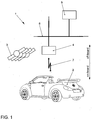
- Fig. 1 shows an embodiment of a navigation arrangement 1 for a in Fig. 2 2.
- the navigation arrangement 1 comprises a spatially separated from the motor vehicle 2 off-board navigation system 5 for calculating a route proposal (target route to a destination and / or target direction indication) for the motor vehicle 2.
- the motor vehicle 2 can a node 4 communicate with the off-board navigation system 5 by means of a wireless communication link 7 and a communication network 6.
- Both the wireless communication link 7 and the combination of the wireless communication link 7 with the communication network 6 may be an example of a wireless communication link as defined in the claims.
- the wireless communication link 7 may be WLAN, WIFI, WIMAX, RF, cellular, etc. It can be provided that - depending on certain criteria - (automatic) is chosen between alternative wireless communication links.
- the suggested route may be dependent on current traffic, on construction sites, on weather or environmental conditions and / or on visibility conditions.
- the route suggestion may also be dependent on personal preferences (interesting routes, landmaks, shopping areas).
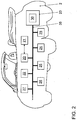
- the motor vehicle 2 comprises a human-machine interface designed as a touch screen 21 for outputting the route proposal to an operator of the motor vehicle 2.
- the touch screen 21 can be controlled by means of a display control 20, which by means of a bus system 35 with an interface 22 for the wireless communication connection 7 connected is.
- the touch screen 21 can - as in the present embodiment - also for Operation of an infotainment system 24, a telephone 25 or an automatic climate control 26 are used.
- the motor vehicle 2 comprises a - in the present embodiment in an on-board navigation system 23 integrated - positioning system 30 for determining the position of the motor vehicle 2, the orientation of the motor vehicle 2 and / or the on-board time in response to satellite 3 sent signals.
- the position of the motor vehicle 2, the orientation of the motor vehicle 2 and / or the on-board time are transferable by means of the wireless communication link 7 to the off-board navigation system 5.
- the position of the motor vehicle 2 may also be a variable from which the position of the motor vehicle 2 can be determined, such as e.g. GPS signals received by the motor vehicle 2. If e.g. transmit the GPS signals received from the motor vehicle to the off-board navigation system 5, this determines the position of the motor vehicle 2 and the orientation of the motor vehicle 2 and possibly the on-board time.
- a destination can also be input, which can likewise be transmitted to the off-board navigation system 5 by means of the wireless communication connection 7.
- the off-board navigation system 5 determines the route proposal and transmits it by means of the wireless communication link 7 to the motor vehicle 2.
- the route suggestion can be displayed, in particular by means of the off-board navigation system 5, integrated into a satellite image or a 3D graphic and / or transferred to the motor vehicle in this form or represented by the touch screen 21. It can be provided that an operator can adjust the viewing angle (for example, from plan view via bird's eye view to first-person-view and vice versa).
- the transmission of the route proposal in a satellite image and / or a 3D graphics or other map information or with respect to the transmission of satellite images and / or 3D graphics or other map information to represent the route suggestion may be hereafter as predictive catching , tunnel vision or profile based prediction.
- predictive catching only satellite imagery and / or 3D graphics or other map information that is needed is transmitted.
- only satellite images and / or 3D graphics or other map information along the recommended route are transmitted with high information density in the tunnel vision strategy.
- the profile based prediction strategy translates satellite imagery and / or 3D graphics or other map information to an operator's preferences.
- the suggested route and the satellite images and / or the 3D graphics or other map information can be stored in a memory designated by reference numeral 28.
- satellite imagery there are different modes, e.g. Night Mode, Day Mode, Seasonal Modes, Weather Modes, etc., can be selected. It can also be provided that a map, a satellite image and / or a 3D graphic is supplemented by information from on-board sensor system 27 (Nigth vision, road condition sensor system).
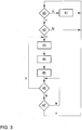
- Fig. 3 shows a simplified embodiment of a procedure for supporting the navigation of the motor vehicle 2, in particular an embodiment of a procedure for operating the navigation system 1.
- the process begins with a query 40, whether the communication link 7 to the off-board navigation system 5 is available. If the communication link 7 to the off-board navigation system 5 is not available, the query 40 is followed by a step 41, which enables the operation of the on-board navigation system. On the other hand, if the communication link 7 to the off-board navigation system 5 is available, the query 40 is followed by a query 42 as to whether a destination input has occurred.
- query 42 again follows query 40. If, on the other hand, a destination input is entered, query 42 is followed by a step 43 in which the position of motor vehicle 2 is determined and in which the desired destination and the position of motor vehicle 2 are indicated the off-board navigation system 5 are transmitted. The step 43 is followed by a step 44, in which by means of the off-board navigation system 5 a route proposal is determined and transmitted to the motor vehicle 2. The step 44 is followed by a step 45 in which the route proposal is displayed by means of the touch screen 21.
- step 45 is followed by a query 46, whether the route proposal should be recalculated and (due to the existing communication link 7) can be recalculated. If and if the route proposal can be recalculated, query 46 is followed by step 43. Otherwise, query 46 is followed by a query 47 as to whether the method sequence is aborted should. If the procedure is to be aborted, query 46 is followed by query 40. Otherwise, query 47 is followed by query 46.
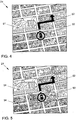
- FIG. 4 shows an embodiment of the touch screen 21 in a situation where the marker 50 and the route 52 are displayed together with the satellite image 51.
- FIG. 5 shows an embodiment of the touch screen 21 in a situation where the marker 50, the route 52, and roads 54 are displayed together with the satellite image 51.
- Fig. 6 shows an exemplary embodiment of a top view representation 61A of a route suggestion 62A integrated in a 3D graphics by means of the touchscreen 21.
- additional information such as points-of-interest (POIs) 63 can also be entered.
- POIs points-of-interest
- a control bar 60 is shown. By means of this control bar 60, the presentation can be changed and / or other and / or additional functions can be activated or operated.
- the route proposal 62B is shown integrated in the bird's-eye view representation.
- Fig. 8 shows an embodiment of a display of an input mask for entering a start and a destination by means of the touch screen 21.
- a start input field 70 and destination input field 71 are provided for this purpose.
- the destination input can be done, for example, alphanumerically by a keyboard 72 shown. Alternatively or additionally, the destination input can also be effected by voice input or character recognition (in particular a character recognition for identifying Asian characters).
- the selection of a location can be done on a map, a satellite image and / or a 3D graphics. In this case, in one embodiment, a zoom function for the map, the satellite image and / or the 3D graphics is provided.
- the starting location may also be the current position of the motor vehicle 2.
- - as in Fig. 9 represented - an operator of the motor vehicle 2 a specific object (restaurant, landmark, shop, gas station, etc.) in a particular search area (street, city, postal code, district, etc.) can search.
- a specific object restaurant, landmark, shop, gas station, etc.
- a particular search area street, city, postal code, district, etc.
- an input mask with an object input field 75 for inputting an object to be searched restaurant, landmark, shop, gas station, etc.
- a region input field 76 for entering the search area (street, city, postal code, district, etc.) is shown.
- the operator can then select a hit from the determined by this search or (for example, in a map, in a satellite image and / or in a 3D graphics) offered hits.
- a graphical confirmation 82 of the speech input can - as in Fig. 10 shown - for example (limited in time) superimpose a map display.
- Fig. 11 an embodiment of a display for selecting preferred routes by means of the touch screen 21st
- an automatic or at least an interactive-automatic destination selection may also be provided under certain circumstances.
- the motor vehicle 2 transmits operating information of the motor vehicle 2 (by means of the wireless communication connection 7) or transmits (via the wireless communication connection 7) to the off-board navigation system 5.
- Operating information of the motor vehicle in this sense may e.g. the status of the tank filling, the oil level, or information about a defect. If e.g. transferred, that the tank is almost empty, a navigation to the nearest gas station is offered and / or provided. If e.g. transferred, that a certain defect is present, a navigation to the next (suitable) service station is offered and / or provided.
- Fig. 12 shows an embodiment of a display of a route overview by means of the touch screen 21.
- reference numeral 90 denotes a satellite image and reference numeral 91 a route proposal.
- the route overview can also be done in a fly-through mode, in particular from a bird's-eye view.
- Satellite imagery 100 may - as exemplified in FIG Fig. 13 represented - also by additional information 101, such as roads, street names or names, buildings, vehicles, traffic information, (possibly customized) POIs, call-out boxes, service areas, etc. are superimposed or supplemented. Special instructions on service areas or parking spaces can be provided, for example, when a certain driving time has been exceeded.
- a follow-me function is also provided, in which the position 116 of a selected other motor vehicle is displayed on a map, a satellite image and / or a 3D graphic 110, in particular together with the position 115 of the motor vehicle 2.
- a route suggestion 111 can be displayed.
Landscapes
- Engineering & Computer Science (AREA)
- Remote Sensing (AREA)
- Radar, Positioning & Navigation (AREA)
- Automation & Control Theory (AREA)
- Physics & Mathematics (AREA)
- General Physics & Mathematics (AREA)
- Navigation (AREA)
Description
- Die Erfindung betrifft ein Kraftfahrzeug mit einem Navigationssystem, wobei das Navigationssystem ein Ortungssystem zur Bestimmung der Position des Kraftfahrzeuges umfasst.
- Die
EP 0 875 730 B1 und dieDE 698 15 940 T2 offenbaren ein Landkarteninformationsanzeigegerät zur Verwendung in einer Fahrzeugnavigationsvorrichtung mit einer Datenumsetzungseinrichtung zum Erfassen von Punkten von Kartendaten entsprechend einer Landkarte von einem Standpunkt durch eine Betrachtungslinie, die von dem Standpunkt ausgeht und bezüglich der Ebene der Landkarte einen Tiefenwinkel besitzt, und zum perspektivischen Projizieren der Punkte der Kartendaten auf eine Betrachtungsebene, die senkrecht zu der Betrachtungslinie festgelegt ist und einen vorgegebenen Abstand von dem Standpunkt besitzt, um Landkarten-Anzeigedaten zu erzeugen. Dabei wird eine Ansicht einer Umgebung aus der Vogelperspektive erzeugt. Ein Navigationssystem mit einer Ansicht einer Umgebung aus der Vogelperspektive ist zudem in derFR 2634707 - Die
EP 0 990 119 B1 offenbart eine digitale Personal-Kommunikationsvorrichtung mit einem Prozessor, mit einem Speicher, auf den der Prozessor zugreifen kann, und mit einer Anzeige, die mit dem Prozessor verbunden ist, wobei die Anzeige Karteninformationen und eine Position der digitalen Personal-Kommunikationsvorrichtung bezüglich der Karteninformation anzeigt, wobei die Karteninformation Wegpunkte, also Koordinaten enthält, wie vom Prozessor angewiesen. Die digitale Personal-Kommunikationsvorrichtung umfasst zudem eine Eingabeeinrichtung zum Bilden von Anfragen für Karteninformation und zum Auswählen von Wegpunkten und einen GPS-Empfänger, der mit dem Prozessor verbunden ist, wobei der Prozessor so programmiert ist, dass er Informationen, die er vom GPS-Empfänger erhält, so verarbeitet, dass daraus die Position der digitalen Personal-Kommunikationsvorrichtung bestimmt wird. Außerdem umfasst die digitale Personal-Kommunikationsvorrichtung einen Sender, der mit dem Prozessor verbunden ist, wobei der Prozessor so programmiert ist, dass er Karteninformation unter Verwendung des Senders von einem Kartenspeicher und einer Übertragungsvorrichtung anfordert, dass er die Karteninformation, die er vom Kartenspeicher und der Übertragungsvorrichtung erhalten hat, weiterverarbeitet, und dass er die Verfügbarkeit zusätzlicher gespeicherter Daten für Wegpunkte im Speicher bei Auswahl einer der Wegpunkte durch die Eingabeeinrichtung bestimmt, und dass er zusätzliche gespeicherte Daten unter Verwendung des Senders von dem Kartenspeicher und der Übertragungsvorrichtung bei Auswahl eines der Wegpunkte anfordert, falls zusätzliche gespeicherte Daten nicht im Speicher verfügbar sind. - Die
WO 2005/124280 A1 und dieEP 1 757 904 A2 und offenbaren eine verteilte Navigationsanordnung für ein Kraftfahrzeug. Ein räumlich vom Kraftfahrzeug getrenntes off-board-Navigationssystem berechnet einen Routenvorschlag für das Kraftfahrzeug. Der Routenvorschlag wird dann mittels des off-board-Navigationssystems in eine PNG-Datenstruktur, die ein Satellitenbild oder eine 3D-Graphik darstellt, als Vektordaten integriert und in dieser Form drahtlos über eine Kommunikationsverbindung an das Kraftfahrzeug übertragen. Danach wird mittels einer Mensch-Maschine-Schnittstelle der Routenvorschlag in das Satellitenbild oder die 3D-Graphik integriert dargestellte. - Es ist Aufgabe der Erfindung, ein verbessertes Kraftfahrzeug mit einem Navigationssystem anzugeben.
- Vorgenannte Aufgabe wird durch eine Navigationsanordnung für ein Kraftfahrzeug gemäß Anspruch 1 gelöst.
- Ein Routenvorschlag im Sinne der Erfindung kann z.B. eine Soll-Route zu einem Ziel und/oder eine Soll-Fahrtrichtungsangabe sein.
- Eine drahtlose Kommunikationsverbindung im Sinne der Erfindung kann auch einen nicht drahtlosen Anteil umfassen. Eine drahtlose Kommunikationsverbindung im Sinne der Erfindung ist insbesondere eine Kommunikationsverbindung, die zumindest zum Kraftfahrzeug drahtlos ist. Eine drahtlose Kommunikationsverbindung im Sinne der Erfindung ist insbesondere eine drahtlose Verbindung ins Internet (z.B. WLAN). Drahtlose Kommunikationsverbindungen können auch WIFI, WIMAX, RF, Mobilfunk, etc. sein. Es kann vorgesehen sein, dass - abhängig von bestimmten Kriterien - (automatisch) zwischen alternativen drahtlosen Kommunikationsverbindungen gewählt wird. Diese Kriterien sind z.B. Kosten, Verfügbarkeit und/oder Bandbreite etc.. Darüber hinaus kann ein nahtloser Übergang zwischen einem online- und einem offline-Betrieb vorgesehen sein, wobei ein Routenvorschlag ggf. mit Karteninformation auf einem on-board-Speicher abgespeichert wird.
- In einer weiteren Ausgestaltung der Erfindung ist der Routenvorschlag abhängig vom aktuellen Verkehr, von Baustellen, von Wetter- bzw. Umweltbedingungen und/oder von Sichtverhältnissen. Der Routenvorschlag kann auch abhängig von persönlichen Präferenzen (interessante Routen, Landmaks, Einkaufsgebiete) sein.
- In einer weiteren Ausgestaltung der Erfindung umfasst das Kraftfahrzeug ein Ortungssystem zur Bestimmung der Position des Kraftfahrzeuges, der Ausrichtung des Kraftfahrzeuges und/oder der on-board-Zeit. Dabei ist in einer weiteren Ausgestaltung der Erfindung die Position des Kraftfahrzeuges, die Ausrichtung des Kraftfahrzeuges und/oder die on-board-Zeit mittels der drahtlosen Kommunikationsverbindung an das off-board-Navigationssystem übertragbar. Die Position des Kraftfahrzeuges kann im Sinne der Erfindung auch eine Größe sein, aus der die Position des Kraftfahrzeuges ermittelbar ist, wie z.B. von dem Kraftfahrzeug empfangene GPS-Signale. Werden z.B. die von dem Kraftfahrzeug empfangenen GPS-Signale an das off-board-Navigationssystem übertragen, so ermittelt dieses die Position des Kraftfahrzeuges und die Ausrichtung des Kraftfahrzeuges sowie unter Umständen die on-board-Zeit.
- In einer weiteren Ausgestaltung der Erfindung ist (mittels der Mensch-Maschine-Schnittstelle) ein Ziel eingebbar. Dieses Ziel ist in einer weiteren Ausgestaltung der Erfindung mittels der drahtlosen Kommunikationsverbindung an das off-board-Navigationssystem übertragbar. Die Zieleingabe kann z.B. alphanumerisch erfolgen. Alternativ oder zusätzlich kann die Zieleingabe auch durch Spracheingabe oder Schrifterkennung (insbesondere einer Schrifterkennung zur Identifikation asiatischer Schriftzeichen) erfolgen. Die Selektion eines Ortes kann auf einer Karte, einem Satellitenbild und/oder einer 3D-Graphik erfolgen. In diesem Fall ist in einer weiteren Ausgestaltung der Erfindung eine Zoomfunktion für die Karte, das Satellitenbild und/oder die 3D-Graphik vorgesehen. Es kann vorgesehen sein, dass ein Bediener des Kraftfahrzeuges ein bestimmtes Objekt (Restaurant, Landmark, Geschäft, Tankstelle etc.) in einem bestimmten Gebiet (Straße, Stadt, Postleitzahl, Kreis, etc.) suchen lassen kann und aus den (z.B. in einer Karte, in einem Satellitenbild und/oder in einer 3D-Graphik) angebotenen Treffern ein Navigationsziel aussuchen kann. Ausgangspunkt ist die aktuelle Position des Kraftfahrzeuges. Es kann aber auch vorsehen sein, dass der Ausgangspunkt wählbar ist.
- In einer weiteren Ausgestaltung der Erfindung umfasst off-board-Navigationssystem die Funktionalität einer Suchmaschine. Dies umfasst z.B.
- die Möglichkeit, on-line nach POIs zu suchen und diese in einer Karte, in einem Satellitenbild und/oder in einer 3D-Graphik zu lokalisieren,
- die Möglichkeit, nach Läden oder Restaurants zu suchen und sich das Sortiment bzw. die Speisekarte anzuschauen,
- die Möglichkeit, nach bestimmten Gegenständen zu suchen und Läden zu finden, in denen sie angeboten werden,
- die Möglichkeit, die Präferenzen, bevorzugte Orte und/oder bevorzugte Routen eines Anwenders zu speichern, und/oder
- die Möglichkeit interessante Routen zu finden.
- Gemäß der Erfindung ist der Routenvorschlag mittels des off-board-Navigationssystems integriert in ein Satellitenbild oder eine 3D-Graphik darstellbar und in dieser Form an das Kraftfahrzeug übertragbar. In einer weiteren Ausgestaltung der Erfindung ist ein Satellitenbild oder eine 3D-Graphik von der Umgebung des Kraftfahrzeuges an das Kraftfahrzeug übertragbar. In einer weiteren Ausgestaltung der Erfindung umfasst die in dem Kraftfahrzeug angeordnete Mensch-Maschine-Schnittstelle eine Anzeigevorrichtung, insbesondere einen Touchscreen, zur Darstellung des Routenvorschlags integriert in ein/das Satellitenbild oder in eine/die 3D-Graphik. Dabei kann vorgesehen sein, dass ein Bediener den Blickwinkel einstellen kann (z.B. von Draufsicht über Vogelperspektive zu first-person-view und umgekehrt).
- In Bezug auf die Übertragung des Routenvorschlag in ein Satellitenbild und/oder eine 3D-Graphik oder eine andere Karteninformation bzw. in Bezug auf die Übertragung von Satellitenbildern und/oder 3D-Graphikes oder anderer Karteninformationen zur Darstellung des Routenvorschlags können die im Folgenden als
- predictive catching,
- tunnel vision bzw.
- profile based prediction
- Es kann vorgesehen sein, dass dem Bediener die Option angeboten wird, die vorgeschlagene Route vorab anzuschauen (Fly-Through-Modus).
- Die Mensch-Maschine-Schnittstelle kann einen Touchscreen umfassen oder als Touchscreen ausgestaltet sein. Dabei kann z.B. vorgesehen sein, dass abgebildete Objekte mittels einer Drag-and-Drop-Option verschoben werden können. Auch kann eine Double-tap-Funktion zur Implementierung einer Zoomfunktion vorgesehen sein.
- Die Satellitenbilder können auch durch zusätzliche Informationen, wie z.B. Straßen, Straßennamen bzw. -bezeichnungen, Gebäude, Fahrzeuge, Verkehrsinformationen, (ggf. customized) POIs, call-out-boxes, Raststätten etc. überlagert bzw. ergänzt werden. Besondere Hinweise auf Raststätten oder Parkplätze können z.B. dann vorgesehen werden, wenn eine bestimmte Lenkdauer überschritten worden ist.
- Es kann vorgesehen sein, dass in Bezug auf die Satellitenbilder zwischen verschiedenen Modi, wie z.B. Nachtmodus, Tagmodus, saisonal abhängige Modi, wetterabhängige Modi, etc., gewählt werden kann. Es kann auch vorgesehen sein, dass eine Karte, ein Satellitenbild und/oder eine 3D-Graphik um Informationen von on-board-Sensorik (Nigth-Vision, Straßenzustandssensorik) ergänzt wird.
- Es kann auch eine follow-me-Funktion vorgesehen sein, bei der die Position eines ausgewählten anderen Kraftfahrzeuges auf einer Karte, einem Satellitenbild und/oder einer 3D-Graphik eingetragen wird.
- Es kann auch vorgesehen sein, weitere Informationen, wie z.B. VW Werkstätten oder Einrichtungen, die Sonderkonditionen für VW-Kunden anbieten, auf einer Karte, einem Satellitenbild und/oder einer 3D-Graphik einzutragen.
- In einer weiteren Ausgestaltung der Erfindung umfasst das Kraftfahrzeug zudem ein on-board-Navigationssystem zur Berechnung eines Routenvorschlags für das Kraftfahrzeug. In diesem Fall kann in einer weiteren Ausgestaltung der Erfindung vorgesehen sein, dass Informationen für das on-board-Navigationssystem, wie z.B. eine Straßenkarte, Einbahnstraßen, Hausnummern, Tankstellen, Points-of- Interest (POIs), Informationen über Dauerbaustellen etc. mittels der drahtlosen Kommunikationsverbindung aktualisiert werden.
- In einer weiteren Ausgestaltung der Erfindung ist vorgesehen, dass das Kraftfahrzeug Betriebsinformationen des Kraftfahrzeuges (mittels der drahtlosen Kommunikationsverbindung) sendet bzw. (mittels der drahtlosen Kommunikationsverbindung) an das off-board-Navigationssystem überträgt. Eine Betriebsinformation des Kraftfahrzeuges in diesem Sinne kann z.B. der Status der Tankfüllung, der Ölstand, oder eine Information über einen Defekt sein. Wird z.B. übertragen, dass der Tank fast leer ist, so wird eine Navigation zur nächsten Tankstelle angeboten und/oder vorgesehen. Wird z.B. übertragen, dass ein bestimmter Defekt vorliegt, so wird eine Navigation zur nächsten (geeigneten) Servicestation angeboten und/oder vorgesehen.
- In einer weiteren Ausgestaltung der Erfindung umfasst das Kraftfahrzeug zudem ein Ortungssystem zur Bestimmung der Position des Kraftfahrzeuges.
- In einer weiteren Ausgestaltung der Erfindung ist die Position des Kraftfahrzeuges mittels der drahtlosen Kommunikationsverbindung (an das off-board-Navigationssystem) übertragbar.
- In einer weiteren Ausgestaltung der Erfindung umfasst die in dem Kraftfahrzeug angeordnete Mensch-Maschine-Schnittstelle eine Anzeigevorrichtung zur Darstellung des Routenvorschlags.
- In einer weiteren Ausgestaltung der Erfindung umfasst das Kraftfahrzeug ein on-board-Navigationssystem zur Berechnung eines Routenvorschlags für das Kraftfahrzeug.
- Vorgenannte Aufgabe wird zudem durch ein Verfahren zur Unterstützung der Navigation eines Kraftfahrzeuges gemäß Anspruch 7 gelöst.
- In einer weiteren Ausgestaltung der Erfindung wird ein Satellitenbild und/oder eine 3D-Graphik von der Umgebung des Kraftfahrzeuges an das Kraftfahrzeug übertragen.
- Gemäß der Erfindung erfolgt die Ausgabe des Routenvorschlags an den Bediener des Kraftfahrzeuges durch Darstellung des Routenvorschlags integriert in ein Satellitenbild oder eine 3D-Graphik.
- In einer weiteren Ausgestaltung der Erfindung wird die Position des Kraftfahrzeuges bestimmt. Dabei wird die Position des Kraftfahrzeuges in einer weiteren Ausgestaltung der Erfindung von dem Kraftfahrzeug (an das off-board-Navigationssystem) übertragen.
- Kraftfahrzeug im Sinne der Erfindung ist insbesondere ein individuell im Straßenverkehr benutzbares Landfahrzeug. Kraftfahrzeuge im Sinne der Erfindung sind insbesondere nicht auf Landfahrzeuge mit Verbrennungsmotor beschränkt.
- Die Erfindung ist für die Off-Road-Navigation geeignet.
- Weitere Vorteile und Einzelheiten in Bezug auf die Erfindung ergeben sich aus der nachfolgenden Beschreibung von Ausführungsbeispielen.
- Fig. 1
- zeigt ein Ausführungsbeispiel einer Navigationsanordnung für ein Kraftfahrzeug
- Fig. 2
- zeigt ein Ausführungsbeispiel eines Kraftfahrzeuges mit einem Navigationssystem in einer Prinzipdarstellung;
- Fig. 3
- zeigt ein Ausführungsbeispiel eines Verfahrens zur Unterstützung der Navigation eines Kraftfahrzeuges;
- Fig. 4
- zeigt ein Ausführungsbeispiel einer Anzeige einer in ein Satellitenbild integrierten Route mittels eines Touchscreens;
- Fig. 5
- zeigt ein weiteres Ausführungsbeispiel einer Anzeige einer in ein Satellitenbild integrierten Route mittels eines Touchscreens;
- Fig. 6
- zeigt ein Ausführungsbeispiel einer Draufsicht-Darstellung einer in eine 3D-Graphik integrierten Route mittels eines Touchscreens;
- Fig. 7
- zeigt ein Ausführungsbeispiel einer Vogelperspektive-Darstellung einer in eine 3D-Graphik integrierten Route mittels eines Touchscreens;
- Fig. 8
- zeigt ein Ausführungsbeispiel einer Anzeige einer Eingabemaske zur Eingabe eines Start- und eines Zielortes mittels eines Touchscreens;
- Fig. 9
- zeigt ein Ausführungsbeispiel einer Anzeige einer Eingabemaske zur Auswahl eines Zielortes mittels eines Touchscreens;
- Fig. 10
- zeigt ein Ausführungsbeispiel einer Anzeige zur Auswahl bevorzugter Routen mittels eines Touchscreens;
- Fig. 11
- zeigt ein Ausführungsbeispiel einer Anzeige einer Routenübersicht mittels eines Touchscreens;
- Fig. 12
- zeigt ein Ausführungsbeispiel einer Anzeige zur Bestätigung einer Spracheingabe mittels eines Touchscreens;
- Fig. 13
- zeigt ein Ausführungsbeispiel einer Anzeige eines durch Informationen ergänzten Satellitenbildes mittels eines Touchscreens; und
- Fig. 14
- zeigt ein Ausführungsbeispiel eines Ausschnittes einer Anzeige eines Routenvorschlags zusammen mit einer follow-me-Funktion.
-
Fig. 1 zeigt ein Ausführungsbeispiel einer Navigationsanordnung 1 für ein inFig. 2 detailliert dargestelltes Kraftfahrzeug 2. Die Navigationsanordnung 1 umfasst ein räumlich von dem Kraftfahrzeug 2 getrenntes off-board-Navigationssystem 5 zur Berechnung eines Routenvorschlags (Soll-Route zu einem Ziel und/oder Soll-Fahrtrichtungsangabe) für das Kraftfahrzeug 2. Das Kraftfahrzeug 2 kann über einen Knoten 4 mittels einer drahtlosen Kommunikationsverbindung 7 und ein Kommunikationsnetzwerk 6 mit dem off-board-Navigationssystem 5 kommunizieren. Sowohl die drahtlose Kommunikationsverbindung 7 als auch die Kombination der drahtlosen Kommunikationsverbindung 7 mit dem Kommunikationsnetzwerk 6 können ein Beispiel für eine drahtlose Kommunikationsverbindung im Sinne der Ansprüche sein. Die drahtlose Kommunikationsverbindung 7 kann WLAN, WIFI, WIMAX, RF, Mobilfunk, etc. sein. Es kann vorgesehen sein, dass - abhängig von bestimmten Kriterien - (automatisch) zwischen alternativen drahtlosen Kommunikationsverbindungen gewählt wird. Diese Kriterien sind z.B. Kosten, Verfügbarkeit und/oder Bandbreite etc.. Der Routenvorschlag kann abhängig vom aktuellen Verkehr, von Baustellen, von Wetter- bzw. Umweltbedingungen und/oder von Sichtverhältnissen sein. Der Routenvorschlag kann auch abhängig von persönlichen Präferenzen (interessante Routen, Landmaks, Einkaufsgebiete) sein. - Das Kraftfahrzeug 2 umfasst eine als Touchscreen 21 ausgestaltete Mensch-Maschine-Schnittstelle zur Ausgabe des Routenvorschlags an einen Bediener des Kraftfahrzeuges 2. Dazu ist der Touchscreen 21 mittels einer Anzeigesteuerung 20 ansteuerbar, die mittels eines Bussystems 35 mit einer Schnittstelle 22 für die drahtlose Kommunikationsverbindung 7 verbunden ist. Der Touchscreen 21 kann - wie im vorliegenden Ausführungsbeispiel - auch zur Bedienung eines Infotainmentsystems 24, eines Telefons 25 oder einer Klimaautomatik 26 genutzt werden.
- Das Kraftfahrzeug 2 umfasst ein - im vorliegenden Ausführungsbeispiel in ein on-board-Navigationssystem 23 integriertes - Ortungssystem 30 zur Bestimmung der Position des Kraftfahrzeuges 2, der Ausrichtung des Kraftfahrzeuges 2 und/oder der on-board-Zeit in Abhängigkeit von von Satelliten 3 gesendeten Signalen. Die Position des Kraftfahrzeuges 2, die Ausrichtung des Kraftfahrzeuges 2 und/oder die on-board-Zeit sind mittels der drahtlosen Kommunikationsverbindung 7 an das off-board-Navigationssystem 5 übertragbar. Die Position des Kraftfahrzeuges 2 kann auch eine Größe sein, aus der die Position des Kraftfahrzeuges 2 ermittelbar ist, wie z.B. von dem Kraftfahrzeug 2 empfangene GPS-Signale. Werden z.B. die von dem Kraftfahrzeug empfangenen GPS-Signale an das off-board-Navigationssystem 5 übertragen, so ermittelt dieses die Position des Kraftfahrzeuges 2 und die Ausrichtung des Kraftfahrzeuges 2 sowie unter Umständen die on-board-Zeit.
- Mittels des Touchscreens 21 ist auch ein Ziel eingebbar, das ebenfalls mittels der drahtlosen Kommunikationsverbindung 7 an das off-board-Navigationssystem 5 übertragbar ist. In Abhängigkeit der Position des Kraftfahrzeuges 2 und des gewünschten Ziels ermittelt das off-board-Navigationssystem 5 den Routenvorschlag und übermittelt ihn mittels der drahtlosen Kommunikationsverbindung 7 an das Kraftfahrzeug 2.
- Der Routenvorschlag ist, insbesondere mittels des off-board-Navigationssystems 5, integriert in ein Satellitenbild oder eine 3D-Graphik darstellbar und/oder in dieser Form an das Kraftfahrzeug übertragbar bzw. mittels des Touchscreens 21 darstellbar. Dabei kann vorgesehen sein, dass ein Bediener den Blickwinkel einstellen kann (z.B. von Draufsicht über Vogelperspektive zu first-person-view und umgekehrt).
- In Bezug auf die Übertragung des Routenvorschlag in ein Satellitenbild und/oder eine 3D-Graphik oder eine andere Karteninformation bzw. in Bezug auf die Übertragung von Satellitenbildern und/oder 3D-Graphiken oder anderer Karteninformationen zur Darstellung des Routenvorschlags können die im Folgenden als predictive catching, tunnel vision bzw. profile based prediction bezeichneten Strategien vorgesehen werden. Beim predictive catching werden nur Satellitenbilder und/oder 3D-Graphiken oder andere Karteninformationen übertragen, die auch gebraucht werden. Erfindungsgemäß werden bei der Strategie "tunnel vision" nur Satellitenbilder und/oder 3D-Graphiken oder andere Karteninformationen entlang des Routenvorschlags mit hoher Informationsdichte übertragen. An der Peripherie der Route werden die Satellitenbilder und/oder 3D-Graphiken oder andere Karteninformationen dagegen mit geringer Informationsdichte übertragen. Bei der Strategie "profile based prediction" werden Satellitenbilder und/oder 3D-Graphiken oder andere Karteninformationen angepasst an die Präferenzen eines Bedieners übertragen. Der Routenvorschlag und die Satellitenbilder und/oder die 3D-Graphiken oder andere Karteninformationen können in einem mit Bezugszeichen 28 bezeichneten Speicher abgespeichert werden.
- Es kann vorgesehen sein, dass in Bezug auf die Satellitenbilder zwischen verschiedenen Modi, wie z.B. Nachtmodus, Tagmodus, saisonal abhängige Modi, wetterabhängige Modi, etc., gewählt werden kann. Es kann auch vorgesehen sein, dass eine Karte, ein Satellitenbild und/oder eine 3D-Graphik um Informationen von on-board-Sensorik 27 (Nigth-Vision, Straßenzustandssensorik) ergänzt wird.
-
Fig. 3 zeigt ein vereinfachtes Ausführungsbeispiel eines Verfahrensablaufs zur Unterstützung der Navigation des Kraftfahrzeuges 2, insbesondere ein Ausführungsbeispiel eines Verfahrensablaufs zum Betrieb der Navigationsanordnung 1. Der Verfahrensablauf beginnt mit einer Abfrage 40, ob die Kommunikationsverbindung 7 zum off-board-Navigationssystem 5 zur Verfügung steht. Steht die Kommunikationsverbindung 7 zum off-board-Navigationssystem 5 nicht zur Verfügung, so folgt der Abfrage 40 ein Schritt 41, der die Bedienung des on-board-Navigationssystems ermöglicht. Steht die Kommunikationsverbindung 7 zum off-board-Navigationssystem 5 dagegen zur Verfügung, so folgt der Abfrage 40 eine Abfrage 42, ob eine Zieleingabe erfolgt. - Erfolgt keine Zieleingabe, so folgt der Abfrage 42 erneut die Abfrage 40. Erfolgt dagegen eine Zieleingabe, so folgt der Abfrage 42 ein Schritt 43, in dem die Position des Kraftfahrzeuges 2 bestimmt wird und in dem das gewünschte Ziel und die Position des Kraftfahrzeuges 2 an das off-board-Navigationssystem 5 übertragen werden. Dem Schritt 43 folgt ein Schritt 44, in dem mittels des off-board-Navigationssystems 5 ein Routenvorschlag ermittelt und an das Kraftfahrzeug 2 übertragen wird. Dem Schritt 44 folgt ein Schritt 45, in dem der Routenvorschlag mittels des Touchscreens 21 angezeigt wird.
- Dem Schritt 45 folgt eine Abfrage 46, ob der Routenvorschlag neu berechnet werden soll und (aufgrund der bestehenden Kommunikationsverbindung 7) neu berechnet werden kann. Soll und kann der Routenvorschlag neu berechnet werden, so folgt der Abfrage 46 der Schritt 43. Andernfalls folgt der Abfrage 46 eine Abfrage 47, ob der Verfahrensablauf abgebrochen werden soll. Soll der Verfahrensablauf abgebrochen werden, so folgt der Abfrage 46 die Abfrage 40. Andernfalls folgt der Abfrage 47 die Abfrage 46.
-
Fig. 4 zeigt ein Ausführungsbeispiel des Touchscreens 21 in einer Situation, in der die Markierung 50 und die Route 52 zusammen mit dem bzw. in dem Satellitenbild 51 dargestellt werden.Fig. 5 zeigt ein Ausführungsbeispiel des Touchscreens 21 in einer Situation, in der die Markierung 50, die Route 52 und Straßen 54 zusammen mit dem bzw. in dem mit Satellitenbild 51 dargestellt werden. -
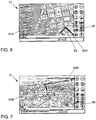
Fig. 6 zeigt ein Ausführungsbeispiel einer Draufsicht-Darstellung 61A eines in eine 3D-Graphik integrierten Routenvorschlags 62A mittels des Touchscreens 21. In dieser Darstellung können auch zusätzliche Informationen wie Points-Of-Interest (POIs) 63 eingetragen werden. Neben der Draufsicht-Darstellung 61A der 3D-Graphik ist eine Bedienleiste 60 dargestellt. Mittels dieser Bedienleiste 60 kann die Darstellung verändert werden und/oder andere und/oder zusätzliche Funktionen aktiviert bzw. bedient werden. So kann mittels der Bedienleiste 60 die inFig. 6 gewählte Draufsicht-Darstellung 61A der 3D-Graphik - wie inFig. 7 dargestellt - in eine Vogelperspektive-Darstellung 61 B verändert werden. Entsprechend wird der Routenvorschlag 62B in der Vogelperspektiven-Darstellung integriert dargestellt. -
Fig. 8 zeigt ein Ausführungsbeispiel einer Anzeige einer Eingabemaske zur Eingabe eines Start- und eines Zielortes mittels des Touchscreens 21. In dem dargestellten Ausführungsbeispiel sind dazu ein Starteingabefeld 70 und Zieleingabefeld 71 vorgesehen. Die Zieleingabe kann z.B. alphanumerisch durch eine dargestellte Tastatur 72 erfolgen. Alternativ oder zusätzlich kann die Zieleingabe auch durch Spracheingabe oder Schrifterkennung (insbesondere einer Schrifterkennung zur Identifikation asiatischer Schriftzeichen) erfolgen. Die Selektion eines Ortes kann auf einer Karte, einem Satellitenbild und/oder einer 3D-Graphik erfolgen. In diesem Fall ist in einer Ausgestaltung eine Zoomfunktion für die Karte, das Satellitenbild und/oder die 3D-Graphik vorgesehen. Der Startort kann auch die aktuelle Position des Kraftfahrzeugs 2 sein. - Es kann auch vorgesehen sein, dass - wie in
Fig. 9 dargestellt - ein Bediener des Kraftfahrzeuges 2 ein bestimmtes Objekt (Restaurant, Landmark, Geschäft, Tankstelle etc.) in einem bestimmten Such-Gebiet (Straße, Stadt, Postleitzahl, Kreis, etc.) suchen lassen kann. Dazu wird eine Eingabemaske mit einem Objekteingabefeld 75 zu Eingabe eines zu suchenden Objektes (Restaurant, Landmark, Geschäft, Tankstelle etc.) und ein Gebietseingabefeld 76 zu Eingabe des Such-Gebiets (Straße, Stadt, Postleitzahl, Kreis, etc.) dargestellt. Der Bediener kann anschließend einen Treffer aus den mittels dieser Suche ermittelten bzw. (z.B. in einer Karte, in einem Satellitenbild und/oder in einer 3D-Graphik) angebotenen Treffer aussuchen. - Erfolgt die Zieleingabe durch Spracheingabe so kann - wie in
Fig. 10 dargestellt - eine graphische Bestätigung 82 der Spracheingabe erfolgen. Diese graphische Bestätigung 82 kann - wie inFig. 10 dargestellt - z.B. (zeitlich begrenzt) eine Kartendarstellung überlagern. So zeigt das Ausführungsbeispiel gemäßFig. 10 z.B. eine Vogelperspektiven-Darstellung 80 eines in eine 3D-Graphik integrierten Routenvorschlags 81 mittels des Touchscreens 21. - Es kann auch vorgesehen sein, dass bevorzugte Routen wählbar sind. So zeigt
Fig. 11 ein Ausführungsbeispiel einer Anzeige zur Auswahl bevorzugter Routen mittels des Touchscreens 21. - Es kann auch eine automatische oder zumindest eine interaktiv-automatische Zielauswahl unter bestimmten Umständen vorgesehen sein. So kann vorgesehen sein, dass das Kraftfahrzeug 2 Betriebsinformationen des Kraftfahrzeuges 2 (mittels der drahtlosen Kommunikationsverbindung 7) sendet bzw. (mittels der drahtlosen Kommunikationsverbindung 7) an das off-board-Navigationssystem 5 überträgt. Eine Betriebsinformation des Kraftfahrzeuges in diesem Sinne kann z.B. der Status der Tankfüllung, der Ölstand, oder eine Information über einen Defekt sein. Wird z.B. übertragen, dass der Tank fast leer ist, so wird eine Navigation zur nächsten Tankstelle angeboten und/oder vorgesehen. Wird z.B. übertragen, dass ein bestimmter Defekt vorliegt, so wird eine Navigation zur nächsten (geeigneten) Servicestation angeboten und/oder vorgesehen.
-
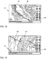
Fig. 12 zeigt ein Ausführungsbeispiel einer Anzeige einer Routenübersicht mittels des Touchscreens 21. Dabei bezeichnet Bezugszeichen 90 ein Satellitenbild und Bezugszeichen 91 einen Routenvorschlag. Die Routenübersicht kann auch, insbesondere aus der Vogelperspektive, in einem Fly-Through-Modus erfolgen. - Satellitenbilder 100 können - wie beispielhaft in
Fig. 13 dargestellt - auch durch zusätzliche Informationen 101, wie z.B. Straßen, Straßennamen bzw. -bezeichnungen, Gebäude, Fahrzeuge, Verkehrsinformationen, (ggf. customized) POIs, call-out-boxes, Raststätten etc. überlagert bzw. ergänzt werden. Besondere Hinweise auf Raststätten oder Parkplätze können z.B. dann vorgesehen werden, wenn eine bestimmte Lenkdauer überschritten worden ist. - Es kann-wie in
Fig. 14 dargestellt - auch eine follow-me-Funktion vorgesehen sein, bei der die Position 116 eines ausgewählten anderen Kraftfahrzeuges auf einer Karte, einem Satellitenbild und/oder einer 3D-Graphik 110, insbesondere zusammen mit der Position 115 des Kraftfahrzeuges 2, dargestellt wird. Darüber hinaus kann ein Routenvorschlag 111 dargestellt werden. -
- 1
- Navigationsanordnung
- 2
- Kraftfahrzeug
- 3
- Satellit
- 4
- Knoten
- 5
- off-board-Navigationssystem
- 6
- Kommunikationsnetzwerk
- 7
- Kommunikationsverbindung
- 20
- Anzeigesteuerung
- 21
- Touchscreen
- 22
- Schnittstelle
- 23
- on-board-Navigationssystem
- 24
- Infotainmentsystem
- 25
- Telefon
- 26
- Klimaautomatik
- 27
- on-board-Sensorik
- 28
- Speicher
- 30
- Ortungssystem
- 35
- Bussystem
- 40, 42, 46, 47
- Abfrage
- 41, 43, 44, 45
- Schritt
- 50
- Markierung
- 51, 90, 100
- Satellitenbild
- 52
- Route
- 54
- Straßen
- 60
- Bedienleiste
- 61A
- Draufsicht-Darstellung
- 61B, 80
- Vogelperspektiven-Darstellung
- 62A, 62B, 81,
- 91, 111
- Routenvorschlag
- 63
- Points-Of-Interest
- 70
- Starteingabefeld
- 71
- Zieleingabefeld
- 72
- Tastatur
- 75
- Objekteingabefeld
- 76
- Gebietseingabefeld
- 82
- graphische Bestätigung
- 101
- zusätzliche Informationen
- 110
- 3D-Graphik
- 115
- Position eines Kraftfahrzeuges
- 116
- Position eines ausgewählten anderen Kraftfahrzeuges
Claims (9)
- Navigationsanordnung (1) für ein Kraftfahrzeug (2), die Navigationsanordnung umfassend:ein räumlich von dem Kraftfahrzeug getrenntes off-board-Navigationssystem (5) zur Berechnung eines Routenvorschlags (52, 62A, 62B) für das Kraftfahrzeug;eine drahtlose Kommunikationsverbindung (7) zwischen dem off-board-Navigationssystem und dem Kraftfahrzeug zur Übertragung des Routenvorschlags an das Kraftfahrzeug; undeine in dem Kraftfahrzeug angeordnete Mensch-Maschine-Schnittstelle (21) zur Ausgabe des Routenvorschlags an einen Bediener des Kraftfahrzeuges,dadurch gekennzeichnet, dass
der Routenvorschlag mittels des off-board-Navigationssystems integriert in ein Satellitenbild (51) oder eine 3D-Graphik (61A, 61B) darstellbar und in dieser Form an das Kraftfahrzeug übertragbar ist, wobei nur Satellitenbilder oder 3D-Graphiken entlang des Routenvorschlags mit hoher Informationsdichte übertragen werden, und wobei an der Peripherie des Routenvorschlags die Satellitenbilder oder 3D-Graphiken mit geringer Informationsdichte übertragen werden. - Navigationsanordnung nach Anspruch 1, das Kraftfahrzeug umfassend:ein Ortungssystem (30) zur Bestimmung der Position des Kraftfahrzeuges.
- Navigationsanordnung nach Anspruch 2, wobei die Position des Kraftfahrzeuges mittels der drahtlosen Kommunikationsverbindung an das off-board-Navigationssystem übertragbar ist.
- Navigationsanordnung nach Anspruch 1, wobei ein Satellitenbild oder eine 3D-Graphik von der Umgebung des Kraftfahrzeuges an das Kraftfahrzeug übertragbar ist.
- Navigationsanordnung nach Anspruch 1 oder 4, wobei die in dem Kraftfahrzeug angeordnete Mensch-Maschine-Schnittstelle (21) eine Anzeigevorrichtung zur Darstellung des Routenvorschlags integriert in das Satellitenbild oder in die 3D-Graphik umfasst.
- Navigationsanordnung nach Anspruch 1, das Kraftfahrzeug weiterhin umfassend:ein on-board-Navigationssystem (23) zur Berechnung eines Routenvorschlags für das Kraftfahrzeug.
- Verfahren zur Unterstützung der Navigation eines Kraftfahrzeuges (2), das Verfahren umfassend:Übertragung eines in ein Satellitenbild (51) oder eine 3D-Graphik (61A, 61B) integrierten Routenvorschlags (52, 62A, 62B) von einem räumlich von dem Kraftfahrzeug getrennten off-board-Navigationssystem (5) an das Kraftfahrzeug mittels einer drahtlosen Kommunikationsverbindung (7),wobei nur Satellitenbilder oder 3D-Graphiken entlang des Routenvorschlags mit hoher Informationsdichte übertragen werden, und wobei an der Peripherie des Routenvorschlags die Satellitenbilder oder 3D-Graphiken mit geringer Informationsdichte übertragen werden; undAusgabe (45) des Routenvorschlags an einen Bediener des Kraftfahrzeuges integriert in ein Satellitenbild oder eine 3D-Graphik.
- Verfahren nach Anspruch 7, das Verfahren weiterhin umfassend:Bestimmung der Position des Kraftfahrzeuges.
- Verfahren nach Anspruch 8, das Verfahren weiterhin umfassend:Übertragung der Position des Kraftfahrzeuges von dem Kraftfahrzeug an das off-board-Navigationssystem.
Applications Claiming Priority (2)
| Application Number | Priority Date | Filing Date | Title |
|---|---|---|---|
| US11/395,705 US20070233371A1 (en) | 2006-03-31 | 2006-03-31 | Navigation system for a motor vehicle |
| PCT/EP2007/001904 WO2007115614A1 (de) | 2006-03-31 | 2007-03-06 | Navigationsanordnung und navigationsverfahren für ein kraftfahrzeug |
Publications (2)
| Publication Number | Publication Date |
|---|---|
| EP2005116A1 EP2005116A1 (de) | 2008-12-24 |
| EP2005116B1 true EP2005116B1 (de) | 2016-05-11 |
Family
ID=38093473
Family Applications (1)
| Application Number | Title | Priority Date | Filing Date |
|---|---|---|---|
| EP07723049.8A Not-in-force EP2005116B1 (de) | 2006-03-31 | 2007-03-06 | Navigationsanordnung und navigationsverfahren für ein kraftfahrzeug |
Country Status (4)
| Country | Link |
|---|---|
| US (2) | US20070233371A1 (de) |
| EP (1) | EP2005116B1 (de) |
| CN (3) | CN101421587A (de) |
| WO (1) | WO2007115614A1 (de) |
Families Citing this family (47)
| Publication number | Priority date | Publication date | Assignee | Title |
|---|---|---|---|---|
| US8700308B2 (en) * | 2006-03-31 | 2014-04-15 | Volkswagen Ag | Navigation system for a motor vehicle |
| US8554463B2 (en) * | 2006-03-31 | 2013-10-08 | Volkswagen Ag | Navigation system for a motor vehicle |
| US20070233371A1 (en) | 2006-03-31 | 2007-10-04 | Arne Stoschek | Navigation system for a motor vehicle |
| US9478133B2 (en) * | 2006-03-31 | 2016-10-25 | Volkswagen Ag | Motor vehicle and navigation arrangement for a motor vehicle |
| US9052214B2 (en) | 2006-05-22 | 2015-06-09 | Volkswagen Ag | Navigation system for a motor vehicle, method for operating a navigation system and motor vehicle including a navigation system |
| US7739006B2 (en) * | 2007-02-07 | 2010-06-15 | Disney Enterprises, Inc. | System and method for autonomous navigation in a ride vehicle |
| US7912637B2 (en) | 2007-06-25 | 2011-03-22 | Microsoft Corporation | Landmark-based routing |
| US20090187300A1 (en) * | 2008-01-22 | 2009-07-23 | David Wayne Everitt | Integrated vehicle computer system |
| US8682573B2 (en) * | 2010-08-20 | 2014-03-25 | Deere & Company | Method of initiating vehicle movement |
| US8630791B2 (en) | 2011-03-04 | 2014-01-14 | Honda Motor Co., Ltd. | Dynamic route guidance |
| DE102011077948A1 (de) * | 2011-06-22 | 2012-12-27 | Robert Bosch Gmbh | Verfahren zum Bereitstellen von Fahrempfehlungen, Navigationsgerät |
| CN102724626B (zh) * | 2012-05-18 | 2015-12-16 | 上海通号轨道交通工程技术研究中心有限公司 | 一种野外定位搜救通信系统 |
| US8965696B2 (en) | 2012-06-05 | 2015-02-24 | Apple Inc. | Providing navigation instructions while operating navigation application in background |
| US10156455B2 (en) | 2012-06-05 | 2018-12-18 | Apple Inc. | Context-aware voice guidance |
| US9482296B2 (en) | 2012-06-05 | 2016-11-01 | Apple Inc. | Rendering road signs during navigation |
| US8880336B2 (en) | 2012-06-05 | 2014-11-04 | Apple Inc. | 3D navigation |
| US9047691B2 (en) | 2012-06-05 | 2015-06-02 | Apple Inc. | Route display and review |
| US20130321400A1 (en) | 2012-06-05 | 2013-12-05 | Apple Inc. | 3D Map Views for 3D Maps |
| US9418672B2 (en) | 2012-06-05 | 2016-08-16 | Apple Inc. | Navigation application with adaptive instruction text |
| US9886794B2 (en) | 2012-06-05 | 2018-02-06 | Apple Inc. | Problem reporting in maps |
| US9418478B2 (en) * | 2012-06-05 | 2016-08-16 | Apple Inc. | Methods and apparatus for building a three-dimensional model from multiple data sets |
| US9367959B2 (en) | 2012-06-05 | 2016-06-14 | Apple Inc. | Mapping application with 3D presentation |
| US10176633B2 (en) | 2012-06-05 | 2019-01-08 | Apple Inc. | Integrated mapping and navigation application |
| US9182243B2 (en) * | 2012-06-05 | 2015-11-10 | Apple Inc. | Navigation application |
| US9997069B2 (en) | 2012-06-05 | 2018-06-12 | Apple Inc. | Context-aware voice guidance |
| US9002567B2 (en) * | 2013-01-07 | 2015-04-07 | Cloudcar, Inc. | Course-based place searching |
| DE102013006026A1 (de) * | 2013-04-08 | 2014-10-09 | Audi Ag | Orientierungszoom in Navigationskarten bei Darstellung auf kleinen Bildschirmen |
| CN105501152B (zh) * | 2014-09-25 | 2018-02-06 | 大陆汽车电子(芜湖)有限公司 | 在汽车仪表板上显示基于位置的广告的方法 |
| GB2536650A (en) | 2015-03-24 | 2016-09-28 | Augmedics Ltd | Method and system for combining video-based and optic-based augmented reality in a near eye display |
| GB2558145B (en) * | 2015-10-16 | 2021-07-14 | Ford Global Tech Llc | System and method for pseudo-navigation assistance in a vehicle |
| CN106126219B (zh) * | 2016-06-20 | 2019-05-03 | 扬州大学 | 一种基于目标装配关系自然语言描述的机械手装配任务自主编程方法 |
| US12521201B2 (en) | 2017-12-07 | 2026-01-13 | Augmedics Ltd. | Spinous process clamp |
| EP3787543A4 (de) | 2018-05-02 | 2022-01-19 | Augmedics Ltd. | Registrierung einer bezugsmarke für ein system der erweiterten realität |
| US11766296B2 (en) | 2018-11-26 | 2023-09-26 | Augmedics Ltd. | Tracking system for image-guided surgery |
| US11980506B2 (en) | 2019-07-29 | 2024-05-14 | Augmedics Ltd. | Fiducial marker |
| US12178666B2 (en) | 2019-07-29 | 2024-12-31 | Augmedics Ltd. | Fiducial marker |
| US11382712B2 (en) | 2019-12-22 | 2022-07-12 | Augmedics Ltd. | Mirroring in image guided surgery |
| KR102782927B1 (ko) * | 2020-02-19 | 2025-03-19 | 삼성전자주식회사 | 전자 장치 및 이의 제어 방법 |
| US12239385B2 (en) | 2020-09-09 | 2025-03-04 | Augmedics Ltd. | Universal tool adapter |
| CN112815958A (zh) * | 2021-01-07 | 2021-05-18 | 腾讯科技(深圳)有限公司 | 一种导航对象显示方法、装置、设备及存储介质 |
| US11896445B2 (en) | 2021-07-07 | 2024-02-13 | Augmedics Ltd. | Iliac pin and adapter |
| CN117677820A (zh) * | 2021-07-12 | 2024-03-08 | 苹果公司 | 交互式路由 |
| US12150821B2 (en) | 2021-07-29 | 2024-11-26 | Augmedics Ltd. | Rotating marker and adapter for image-guided surgery |
| US12475662B2 (en) | 2021-08-18 | 2025-11-18 | Augmedics Ltd. | Stereoscopic display and digital loupe for augmented-reality near-eye display |
| WO2023203521A1 (en) | 2022-04-21 | 2023-10-26 | Augmedics Ltd. | Systems and methods for medical image visualization |
| JP2025531829A (ja) | 2022-09-13 | 2025-09-25 | オーグメディックス リミテッド | 画像誘導医療介入のための拡張現実アイウェア |
| US20250189320A1 (en) * | 2023-12-11 | 2025-06-12 | Nuro, Inc. | Methods and apparatus for providing maps for use with autonomy systems |
Family Cites Families (95)
| Publication number | Priority date | Publication date | Assignee | Title |
|---|---|---|---|---|
| GB2100069A (en) | 1981-05-08 | 1982-12-15 | Atomic Energy Authority Uk | Improvements in or relating to electric couplings |
| JPS62212897A (ja) | 1986-03-14 | 1987-09-18 | 住友電気工業株式会社 | ナビゲータ装置 |
| FR2634707B1 (fr) | 1988-07-28 | 1993-02-05 | Peugeot | Dispositif d'aide a la navigation d'un vehicule notamment automobile |
| DE4039887A1 (de) | 1990-12-13 | 1992-06-17 | Bosch Gmbh Robert | Fahrzeugleit- und zielfuehrungssystem |
| US5293308A (en) | 1991-03-26 | 1994-03-08 | Auckland Uniservices Limited | Inductive power distribution system |
| JPH0636186A (ja) | 1992-07-10 | 1994-02-10 | Oki Electric Ind Co Ltd | 路上車両間の情報交換システム |
| JPH07261821A (ja) * | 1994-03-16 | 1995-10-13 | Fanuc Ltd | 負荷による撓みを考慮したロボット軌道計画方法 |
| JPH0886662A (ja) | 1994-07-18 | 1996-04-02 | Sumitomo Electric Ind Ltd | 車載の走行経路表示装置、道路情報送信装置、経路案内システムおよびナビゲーションシステムの表示方法 |
| DE4446779C2 (de) | 1994-12-24 | 1996-12-19 | Daimler Benz Ag | Anordnung zur berührungslosen induktiven Übertragung elektrischer Leistung |
| JPH10241094A (ja) | 1997-02-27 | 1998-09-11 | Toyota Motor Corp | 路車間通信システム |
| JP3568357B2 (ja) | 1997-05-02 | 2004-09-22 | パイオニア株式会社 | ナビゲーション装置における地図情報表示装置及び地図情報表示方法並びにナビゲーション装置における地図情報表示制御プログラムが記録されたコンピュータ読み取り可能な記録媒体 |
| US6148261A (en) * | 1997-06-20 | 2000-11-14 | American Calcar, Inc. | Personal communication system to send and receive voice data positioning information |
| US6680694B1 (en) * | 1997-08-19 | 2004-01-20 | Siemens Vdo Automotive Corporation | Vehicle information system |
| US6285317B1 (en) * | 1998-05-01 | 2001-09-04 | Lucent Technologies Inc. | Navigation system with three-dimensional display |
| AU3302899A (en) * | 1998-10-14 | 2000-05-01 | Siemens Automotive Corporation | Driver information system |
| DE19908869A1 (de) * | 1999-03-01 | 2000-09-07 | Nokia Mobile Phones Ltd | Verfahren zum Ausgeben von Verkehrsinformation in einem Kraftfahrzeug |
| DE60027499T2 (de) * | 1999-03-05 | 2006-11-16 | Hitachi, Ltd. | Informationsdarbietungssystem für mobile Einheiten |
| JP3475123B2 (ja) * | 1999-05-24 | 2003-12-08 | アイシン・エィ・ダブリュ株式会社 | ナビゲーション装置および記憶媒体 |
| JP3454754B2 (ja) | 1999-06-15 | 2003-10-06 | 松下電器産業株式会社 | 車両位置情報提供システムおよびナビゲーション装置 |
| JP3596805B2 (ja) * | 1999-07-29 | 2004-12-02 | 松下電器産業株式会社 | 情報端末装置および経路案内方法 |
| US6647270B1 (en) * | 1999-09-10 | 2003-11-11 | Richard B. Himmelstein | Vehicletalk |
| EP1102510A1 (de) * | 1999-10-12 | 2001-05-23 | Taskin Sakarya | Ortungssystem für mobile Telefone |
| US6826472B1 (en) * | 1999-12-10 | 2004-11-30 | Tele Atlas North America, Inc. | Method and apparatus to generate driving guides |
| US20040204848A1 (en) * | 2002-06-20 | 2004-10-14 | Shigeru Matsuo | Navigation apparatus for receiving delivered information |
| US20030102997A1 (en) * | 2000-02-13 | 2003-06-05 | Hexagon System Engineering Ltd. | Vehicle communication network |
| US6381534B2 (en) * | 2000-02-14 | 2002-04-30 | Fujitsu Limited | Navigation information presenting apparatus and method thereof |
| JP3475142B2 (ja) * | 2000-03-01 | 2003-12-08 | 三菱電機株式会社 | 地図データ送信装置、地図データ送信方法、及び、地図データ送信方法をコンピュータに実行させるためのプログラムを記録したコンピュータ読み取り可能な記録媒体 |
| JP4024450B2 (ja) * | 2000-03-03 | 2007-12-19 | パイオニア株式会社 | ナビゲーションシステム |
| DE10014954A1 (de) | 2000-03-22 | 2001-10-04 | Lju Industrieelektronik Gmbh | Elektrohängebahn mit berührungsloser Energieübertragung |
| DE10019407A1 (de) * | 2000-04-19 | 2001-10-25 | Bosch Gmbh Robert | Verfahren zur Routenberechnung und Verfahren zur Zielführung |
| JP2001333455A (ja) * | 2000-05-23 | 2001-11-30 | Aisin Aw Co Ltd | 移動体広告情報配信方法、移動体広告情報配信システム、移動体広告情報登録システム、移動体広告情報課金システム、移動体通信機器及び記録媒体 |
| US6765495B1 (en) * | 2000-06-07 | 2004-07-20 | Hrl Laboratories, Llc | Inter vehicle communication system |
| FI20001374A0 (fi) * | 2000-06-09 | 2000-06-09 | Arcus Software Oy | Menetelmä tiedonsiirtokapasiteetiltaan ja muistikapasiteeltitaan rajoitetun työaseman käyttäjän reittiopastus kolmiulotteisen mallin avulla |
| EP1174728B1 (de) | 2000-07-18 | 2008-09-24 | Hewlett-Packard Company | Verbreitung der Positionsdaten und Positionsentdeckung |
| JP2002087267A (ja) * | 2000-09-11 | 2002-03-27 | Mitsubishi Electric Corp | 輸送機関における情報提供システム及び情報提供方法 |
| JP2002131065A (ja) | 2000-10-20 | 2002-05-09 | Honda Motor Co Ltd | ナビゲーションシステムおよび情報提供方法 |
| DE10053373B4 (de) | 2000-10-27 | 2019-10-02 | Sew-Eurodrive Gmbh & Co Kg | Verfahren und Vorrichtung zur berührungslosen Energieübertragung |
| US6700504B1 (en) | 2000-11-01 | 2004-03-02 | Navigation Technologies Corp. | Method and system for safe emergency vehicle operation using route calculation |
| ATE288607T1 (de) * | 2001-03-12 | 2005-02-15 | Magellan Dis Inc | Off-board-navigationssystem mit personalisierter navigations-datenbank |
| DE10112892B4 (de) | 2001-03-15 | 2007-12-13 | Paul Vahle Gmbh & Co. Kg | Vorrichtung zur Übertragung von Daten innerhalb eines Systems zur berührungsfreien induktiven Energieübertragung |
| KR100540512B1 (ko) * | 2001-03-21 | 2006-01-12 | 산요덴키가부시키가이샤 | 네비게이션 장치 |
| US6594576B2 (en) * | 2001-07-03 | 2003-07-15 | At Road, Inc. | Using location data to determine traffic information |
| JP2003042772A (ja) * | 2001-07-31 | 2003-02-13 | Pioneer Electronic Corp | 通信ナビゲーションシステム、通信ナビゲーション方法、経路誘導情報送信装置および端末装置 |
| CN1153177C (zh) * | 2001-10-24 | 2004-06-09 | 倚天资讯股份有限公司 | 结合无线通讯系统的较佳路径搜寻系统与方法 |
| EP1473542A4 (de) * | 2002-02-07 | 2010-01-06 | Sanyo Electric Co | Navigationssystem, navigationsvorrichtung und servervorrichtung |
| EP1502078A1 (de) * | 2002-04-30 | 2005-02-02 | Telmap Ltd. | Auf schablonen basiertes kartenverteilungssystem |
| US6865480B2 (en) * | 2002-06-19 | 2005-03-08 | Alpine Electronics, Inc | Display method and apparatus for navigation system |
| US6707378B2 (en) * | 2002-06-25 | 2004-03-16 | Ford Global Technologies, Llc | Inter-vehicle wireless communication and warning system |
| JP4408635B2 (ja) * | 2002-06-27 | 2010-02-03 | ナヴィゲイション テクノロジーズ コーポレイション | 経路情報と共に位置に基づく広告を提供する方法 |
| JP4076071B2 (ja) * | 2002-08-19 | 2008-04-16 | アルパイン株式会社 | 移動体間の通信方法及び車両通信装置 |
| JP3689076B2 (ja) * | 2002-09-05 | 2005-08-31 | 株式会社東芝 | 車載用電子機器 |
| TWI226593B (en) * | 2002-10-28 | 2005-01-11 | Sin Etke Technology Co Ltd | Message transmission method among vehicles and devices thereof |
| US6732597B1 (en) | 2002-11-14 | 2004-05-11 | Robert O. Brandt, Jr. | Precision gravimetric feeder |
| JP2004227162A (ja) | 2003-01-21 | 2004-08-12 | Nissan Motor Co Ltd | 経路案内システム及び経路案内方法 |
| US7161504B2 (en) * | 2003-01-31 | 2007-01-09 | Alpine Electronics, Inc. | Navigation system for finding optimum route using traffic incidents information |
| JP2004241866A (ja) * | 2003-02-03 | 2004-08-26 | Alpine Electronics Inc | 車両間通信装置 |
| DE10312284B4 (de) | 2003-03-19 | 2005-12-22 | Sew-Eurodrive Gmbh & Co. Kg | Übertragerkopf, System zur berührungslosen Energieübertragung und Verwendung eines Übertragerkopfes |
| DE10312792B3 (de) | 2003-03-21 | 2004-08-12 | Sew-Eurodrive Gmbh & Co Kg | Anordnung zur berührungslosen Übertragung elektrischer Leistung |
| US7272497B2 (en) * | 2003-03-24 | 2007-09-18 | Fuji Jukogyo Kabushiki Kaisha | Vehicle navigation system with multi-use display |
| WO2004099721A1 (en) * | 2003-05-12 | 2004-11-18 | Telefonaktiebolaget Lm Ericsson (Publ) | Method and system for generation of real-time guiding information |
| US6925378B2 (en) | 2003-05-12 | 2005-08-02 | Circumnav Networks, Inc. | Enhanced mobile communication device with extended radio, and applications |
| US7383123B2 (en) * | 2003-06-03 | 2008-06-03 | Samsung Electronics Co., Ltd. | System and method of displaying position information including an image in a navigation system |
| JP4118197B2 (ja) * | 2003-06-19 | 2008-07-16 | アルパイン株式会社 | 車車間通信方法及び装置 |
| EP1639566B1 (de) | 2003-06-25 | 2008-08-20 | Julian Weis | Vorrichtung zum datenaustausch zwischen fahrzeugen in bewegung |
| US7110882B2 (en) * | 2003-07-07 | 2006-09-19 | Robert Bosch Gmbh | Method for improving GPS integrity and detecting multipath interference using inertial navigation sensors and a network of mobile receivers |
| CA2531761A1 (en) * | 2003-07-10 | 2005-01-20 | Apricot Co., Ltd. | Road guide system and road guide method |
| DE10338852B4 (de) | 2003-08-20 | 2019-05-29 | Sew-Eurodrive Gmbh & Co Kg | Anordnung zur berührungslosen induktiven Übertragung elektrischer Leistung |
| DE10339340B4 (de) | 2003-08-25 | 2020-02-20 | Sew-Eurodrive Gmbh & Co Kg | Vorrichtung zur berührungslosen Energieübertragung |
| DE10344144C5 (de) | 2003-09-22 | 2016-03-24 | Sew-Eurodrive Gmbh & Co Kg | Anordnung zur berührungslosen induktiven Übertragung elektrischer Leistung |
| US7251558B1 (en) * | 2003-09-23 | 2007-07-31 | Navteq North America, Llc | Method and system for developing traffic messages |
| DE10344120A1 (de) * | 2003-09-24 | 2005-04-21 | Daimler Chrysler Ag | Vorrichtung und Verfahren zur Darstellung von Fahrhinweisen |
| JP2005098868A (ja) | 2003-09-25 | 2005-04-14 | Matsushita Electric Ind Co Ltd | 車載コミュニケーション装置 |
| DE10349242C5 (de) | 2003-10-20 | 2013-04-25 | Sew-Eurodrive Gmbh & Co. Kg | Vorrichtung und Verfahren zur berührungslosen Übertragung elektrischer Leistung und Information |
| US20070138347A1 (en) | 2004-12-16 | 2007-06-21 | Ehlers Gregory A | System and method for providing information to an operator of a vehicle |
| DE102004061782B4 (de) | 2004-03-04 | 2015-05-07 | Volkswagen Ag | Kraftfahrzeug mit einem Instant-Messaging-Kommunikationssystem |
| CN1296856C (zh) * | 2004-03-12 | 2007-01-24 | 倚天资讯股份有限公司 | 小频宽地图撷取传送系统及方法 |
| CA2560386C (en) * | 2004-03-23 | 2013-09-24 | Google Inc. | A digital mapping system |
| US7246007B2 (en) * | 2004-03-24 | 2007-07-17 | General Motors Corporation | System and method of communicating traffic information |
| JP2005286557A (ja) | 2004-03-29 | 2005-10-13 | Xanavi Informatics Corp | 車両間情報通信システム |
| US7680594B2 (en) * | 2004-04-06 | 2010-03-16 | Honda Motor Co., Ltd. | Display method and system for a vehicle navigation system |
| DE102004061781B4 (de) * | 2004-05-04 | 2017-11-23 | Volkswagen Ag | Schlüssel für ein Kraftfahrzeug |
| WO2005124280A1 (ja) * | 2004-06-18 | 2005-12-29 | Navitime Japan Co., Ltd. | 通信型ナビゲーションシステムおよび情報配信サーバならびに携帯ナビゲーション端末 |
| DE102004038740A1 (de) * | 2004-08-10 | 2006-02-23 | Robert Bosch Gmbh | Verfahren zur Darstellung von Karteninformationen |
| JP2006105640A (ja) * | 2004-10-01 | 2006-04-20 | Hitachi Ltd | ナビゲーション装置 |
| US7430473B2 (en) * | 2004-10-01 | 2008-09-30 | Bose Corporation | Vehicle navigation display |
| EP1681663B1 (de) | 2005-01-14 | 2007-08-01 | Alcatel Lucent | Navigationsdienst |
| US8108142B2 (en) * | 2005-01-26 | 2012-01-31 | Volkswagen Ag | 3D navigation system for motor vehicles |
| DE102005013648B4 (de) | 2005-03-24 | 2016-04-07 | Volkswagen Ag | Kommunikationsverbund aus Kraftfahrzeugen sowie existierender, immobiler Netzknoten |
| US9478133B2 (en) * | 2006-03-31 | 2016-10-25 | Volkswagen Ag | Motor vehicle and navigation arrangement for a motor vehicle |
| US20070233371A1 (en) | 2006-03-31 | 2007-10-04 | Arne Stoschek | Navigation system for a motor vehicle |
| US20070233375A1 (en) * | 2006-03-31 | 2007-10-04 | Ashutosh Garg | Providing advertising in aerial imagery |
| US8700308B2 (en) * | 2006-03-31 | 2014-04-15 | Volkswagen Ag | Navigation system for a motor vehicle |
| US9052214B2 (en) * | 2006-05-22 | 2015-06-09 | Volkswagen Ag | Navigation system for a motor vehicle, method for operating a navigation system and motor vehicle including a navigation system |
| US8055444B2 (en) * | 2006-04-04 | 2011-11-08 | Yahoo! Inc. | Content display and navigation interface |
| JP4577327B2 (ja) * | 2007-04-09 | 2010-11-10 | 株式会社デンソー | 地図表示制御装置および地図表示制御装置用のプログラム |
-
2006
- 2006-03-31 US US11/395,705 patent/US20070233371A1/en not_active Abandoned
-
2007
- 2007-03-06 WO PCT/EP2007/001904 patent/WO2007115614A1/de not_active Ceased
- 2007-03-06 EP EP07723049.8A patent/EP2005116B1/de not_active Not-in-force
- 2007-03-06 CN CNA200780012389XA patent/CN101421587A/zh active Pending
- 2007-03-06 CN CN201510042669.1A patent/CN104634357B/zh not_active Expired - Fee Related
- 2007-03-06 CN CN2007800122971A patent/CN101438132B/zh not_active Expired - Fee Related
-
2013
- 2013-07-29 US US13/953,398 patent/US9846051B2/en not_active Expired - Fee Related
Also Published As
| Publication number | Publication date |
|---|---|
| US20130311082A1 (en) | 2013-11-21 |
| CN104634357A (zh) | 2015-05-20 |
| CN101438132A (zh) | 2009-05-20 |
| EP2005116A1 (de) | 2008-12-24 |
| WO2007115614A1 (de) | 2007-10-18 |
| US20070233371A1 (en) | 2007-10-04 |
| CN101421587A (zh) | 2009-04-29 |
| CN104634357B (zh) | 2020-01-03 |
| CN101438132B (zh) | 2013-03-27 |
| US9846051B2 (en) | 2017-12-19 |
Similar Documents
| Publication | Publication Date | Title |
|---|---|---|
| EP2005116B1 (de) | Navigationsanordnung und navigationsverfahren für ein kraftfahrzeug | |
| EP2005114B1 (de) | Navigationsanordnung und navigationsverfahren für ein kraftfahrzeug | |
| EP3115747B1 (de) | Navigationsanordnung für ein kraftfahrzeug | |
| US9052214B2 (en) | Navigation system for a motor vehicle, method for operating a navigation system and motor vehicle including a navigation system | |
| DE69531248T2 (de) | Intelligentes zielführungssystem für fahrzeuge | |
| EP1272995B1 (de) | Verfahren zur ausgabe von daten in einem fahrzeug und fahrerinformationsvorrichtung | |
| US20220215757A1 (en) | Technology for balancing journeys of motor vehicles | |
| DE112004002635T5 (de) | Routensuchverfahren für ein Navigationsgerät | |
| US8600098B2 (en) | Method for processing a satellite image and/or an aerial image | |
| DE10053874B4 (de) | Verfahren zur Navigation und Vorrichtung zu dessen Durchführung | |
| DE112014001209T5 (de) | Navigation entsprechend zulässigen Fahrzeiten | |
| DE102007014485A1 (de) | Kraftfahrzeug und Navigationsanordnung für ein Kraftfahrzeug | |
| EP0944895B1 (de) | Verfahren zur übertragung von eine route eines fahrzeuges in einem verkehrsnetz betreffenden routeninformationen zwischen einer verkehrszentrale und einem endgerät in einem fahrzeug, eine verkehrszentrale und ein endgerät | |
| DE102013222395A1 (de) | Verfahren und Gerät zur Bereitstellung von Umgebungsinformationen für einen Fahrzeugführer | |
| JP2019096124A (ja) | 駐停車場所提案システム | |
| Ness et al. | A prototype low cost in-vehicle navigation system | |
| EP2005117B1 (de) | Navigationsanordnung für ein kraftfahrzeug | |
| DE102015200081A1 (de) | Bereitstellen von Navigationshinweisen in einem Fahrzeug | |
| DE19516964A1 (de) | System zur individuellen, fahrzeugautonomen Zielführung für Straßenfahrzeuge | |
| DE19750777B4 (de) | Verfahren zur Übertragung von einer Route eines Fahrzeuges in einem Verkehrsnetz betreffenden Routeninformationen zwischen einer Verkehrszentrale und einem Endgerät in einem Fahrzeug, eine Verkehrszentrale und ein Endgerät | |
| DE102006047329A1 (de) | Verfahren zur Navigation eines Kraftfahrzeuges | |
| JP4001139B2 (ja) | 案内装置、記録媒体およびシステム | |
| DE102009036676A1 (de) | Navigationssystem für ein Fahrzeug und Verfahren zur Navigationsunterstützung | |
| DE102014001304A1 (de) | Fahrzeug mit einer Informationseinrichtung | |
| DE102008057198A1 (de) | Verfahen zum Betrieb eines Navigationssystems für ein Fahrzeug |
Legal Events
| Date | Code | Title | Description |
|---|---|---|---|
| PUAI | Public reference made under article 153(3) epc to a published international application that has entered the european phase |
Free format text: ORIGINAL CODE: 0009012 |
|
| 17P | Request for examination filed |
Effective date: 20081031 |
|
| AK | Designated contracting states |
Kind code of ref document: A1 Designated state(s): AT BE BG CH CY CZ DE DK EE ES FI FR GB GR HU IE IS IT LI LT LU LV MC MT NL PL PT RO SE SI SK TR |
|
| RIN1 | Information on inventor provided before grant (corrected) |
Inventor name: ROSARIO, DANIEL Inventor name: PHILIPPE, ALESSANDRINI Inventor name: NG, BRIAN Inventor name: STOSCHEK, ARNE |
|
| RAP1 | Party data changed (applicant data changed or rights of an application transferred) |
Owner name: VOLKSWAGEN AKTIENGESELLSCHAFT |
|
| DAX | Request for extension of the european patent (deleted) | ||
| 17Q | First examination report despatched |
Effective date: 20130129 |
|
| REG | Reference to a national code |
Ref country code: DE Ref legal event code: R079 Ref document number: 502007014807 Country of ref document: DE Free format text: PREVIOUS MAIN CLASS: G01C0021340000 Ipc: G01C0021360000 |
|
| RIC1 | Information provided on ipc code assigned before grant |
Ipc: G08G 1/0969 20060101ALI20150724BHEP Ipc: G01C 21/36 20060101AFI20150724BHEP |
|
| GRAP | Despatch of communication of intention to grant a patent |
Free format text: ORIGINAL CODE: EPIDOSNIGR1 |
|
| INTG | Intention to grant announced |
Effective date: 20151016 |
|
| GRAS | Grant fee paid |
Free format text: ORIGINAL CODE: EPIDOSNIGR3 |
|
| GRAA | (expected) grant |
Free format text: ORIGINAL CODE: 0009210 |
|
| AK | Designated contracting states |
Kind code of ref document: B1 Designated state(s): AT BE BG CH CY CZ DE DK EE ES FI FR GB GR HU IE IS IT LI LT LU LV MC MT NL PL PT RO SE SI SK TR |
|
| REG | Reference to a national code |
Ref country code: GB Ref legal event code: FG4D Free format text: NOT ENGLISH |
|
| REG | Reference to a national code |
Ref country code: CH Ref legal event code: EP |
|
| REG | Reference to a national code |
Ref country code: AT Ref legal event code: REF Ref document number: 799003 Country of ref document: AT Kind code of ref document: T Effective date: 20160515 |
|
| REG | Reference to a national code |
Ref country code: IE Ref legal event code: FG4D Free format text: LANGUAGE OF EP DOCUMENT: GERMAN |
|
| REG | Reference to a national code |
Ref country code: DE Ref legal event code: R096 Ref document number: 502007014807 Country of ref document: DE |
|
| REG | Reference to a national code |
Ref country code: LT Ref legal event code: MG4D |
|
| REG | Reference to a national code |
Ref country code: NL Ref legal event code: MP Effective date: 20160511 |
|
| PG25 | Lapsed in a contracting state [announced via postgrant information from national office to epo] |
Ref country code: FI Free format text: LAPSE BECAUSE OF FAILURE TO SUBMIT A TRANSLATION OF THE DESCRIPTION OR TO PAY THE FEE WITHIN THE PRESCRIBED TIME-LIMIT Effective date: 20160511 Ref country code: NL Free format text: LAPSE BECAUSE OF FAILURE TO SUBMIT A TRANSLATION OF THE DESCRIPTION OR TO PAY THE FEE WITHIN THE PRESCRIBED TIME-LIMIT Effective date: 20160511 Ref country code: LT Free format text: LAPSE BECAUSE OF FAILURE TO SUBMIT A TRANSLATION OF THE DESCRIPTION OR TO PAY THE FEE WITHIN THE PRESCRIBED TIME-LIMIT Effective date: 20160511 |
|
| PG25 | Lapsed in a contracting state [announced via postgrant information from national office to epo] |
Ref country code: PT Free format text: LAPSE BECAUSE OF FAILURE TO SUBMIT A TRANSLATION OF THE DESCRIPTION OR TO PAY THE FEE WITHIN THE PRESCRIBED TIME-LIMIT Effective date: 20160912 Ref country code: GR Free format text: LAPSE BECAUSE OF FAILURE TO SUBMIT A TRANSLATION OF THE DESCRIPTION OR TO PAY THE FEE WITHIN THE PRESCRIBED TIME-LIMIT Effective date: 20160812 Ref country code: SE Free format text: LAPSE BECAUSE OF FAILURE TO SUBMIT A TRANSLATION OF THE DESCRIPTION OR TO PAY THE FEE WITHIN THE PRESCRIBED TIME-LIMIT Effective date: 20160511 Ref country code: ES Free format text: LAPSE BECAUSE OF FAILURE TO SUBMIT A TRANSLATION OF THE DESCRIPTION OR TO PAY THE FEE WITHIN THE PRESCRIBED TIME-LIMIT Effective date: 20160511 Ref country code: LV Free format text: LAPSE BECAUSE OF FAILURE TO SUBMIT A TRANSLATION OF THE DESCRIPTION OR TO PAY THE FEE WITHIN THE PRESCRIBED TIME-LIMIT Effective date: 20160511 |
|
| PG25 | Lapsed in a contracting state [announced via postgrant information from national office to epo] |
Ref country code: CZ Free format text: LAPSE BECAUSE OF FAILURE TO SUBMIT A TRANSLATION OF THE DESCRIPTION OR TO PAY THE FEE WITHIN THE PRESCRIBED TIME-LIMIT Effective date: 20160511 Ref country code: DK Free format text: LAPSE BECAUSE OF FAILURE TO SUBMIT A TRANSLATION OF THE DESCRIPTION OR TO PAY THE FEE WITHIN THE PRESCRIBED TIME-LIMIT Effective date: 20160511 Ref country code: SK Free format text: LAPSE BECAUSE OF FAILURE TO SUBMIT A TRANSLATION OF THE DESCRIPTION OR TO PAY THE FEE WITHIN THE PRESCRIBED TIME-LIMIT Effective date: 20160511 Ref country code: RO Free format text: LAPSE BECAUSE OF FAILURE TO SUBMIT A TRANSLATION OF THE DESCRIPTION OR TO PAY THE FEE WITHIN THE PRESCRIBED TIME-LIMIT Effective date: 20160511 Ref country code: EE Free format text: LAPSE BECAUSE OF FAILURE TO SUBMIT A TRANSLATION OF THE DESCRIPTION OR TO PAY THE FEE WITHIN THE PRESCRIBED TIME-LIMIT Effective date: 20160511 |
|
| REG | Reference to a national code |
Ref country code: DE Ref legal event code: R097 Ref document number: 502007014807 Country of ref document: DE |
|
| PG25 | Lapsed in a contracting state [announced via postgrant information from national office to epo] |
Ref country code: PL Free format text: LAPSE BECAUSE OF FAILURE TO SUBMIT A TRANSLATION OF THE DESCRIPTION OR TO PAY THE FEE WITHIN THE PRESCRIBED TIME-LIMIT Effective date: 20160511 |
|
| PLBE | No opposition filed within time limit |
Free format text: ORIGINAL CODE: 0009261 |
|
| STAA | Information on the status of an ep patent application or granted ep patent |
Free format text: STATUS: NO OPPOSITION FILED WITHIN TIME LIMIT |
|
| REG | Reference to a national code |
Ref country code: FR Ref legal event code: PLFP Year of fee payment: 11 |
|
| 26N | No opposition filed |
Effective date: 20170214 |
|
| PG25 | Lapsed in a contracting state [announced via postgrant information from national office to epo] |
Ref country code: SI Free format text: LAPSE BECAUSE OF FAILURE TO SUBMIT A TRANSLATION OF THE DESCRIPTION OR TO PAY THE FEE WITHIN THE PRESCRIBED TIME-LIMIT Effective date: 20160511 |
|
| REG | Reference to a national code |
Ref country code: CH Ref legal event code: PL |
|
| PG25 | Lapsed in a contracting state [announced via postgrant information from national office to epo] |
Ref country code: MC Free format text: LAPSE BECAUSE OF FAILURE TO SUBMIT A TRANSLATION OF THE DESCRIPTION OR TO PAY THE FEE WITHIN THE PRESCRIBED TIME-LIMIT Effective date: 20160511 |
|
| REG | Reference to a national code |
Ref country code: IE Ref legal event code: MM4A |
|
| PG25 | Lapsed in a contracting state [announced via postgrant information from national office to epo] |
Ref country code: LU Free format text: LAPSE BECAUSE OF NON-PAYMENT OF DUE FEES Effective date: 20170306 |
|
| PG25 | Lapsed in a contracting state [announced via postgrant information from national office to epo] |
Ref country code: CH Free format text: LAPSE BECAUSE OF NON-PAYMENT OF DUE FEES Effective date: 20170331 Ref country code: IE Free format text: LAPSE BECAUSE OF NON-PAYMENT OF DUE FEES Effective date: 20170306 Ref country code: LI Free format text: LAPSE BECAUSE OF NON-PAYMENT OF DUE FEES Effective date: 20170331 |
|
| REG | Reference to a national code |
Ref country code: BE Ref legal event code: MM Effective date: 20170331 |
|
| REG | Reference to a national code |
Ref country code: FR Ref legal event code: PLFP Year of fee payment: 12 |
|
| REG | Reference to a national code |
Ref country code: AT Ref legal event code: MM01 Ref document number: 799003 Country of ref document: AT Kind code of ref document: T Effective date: 20170306 |
|
| PG25 | Lapsed in a contracting state [announced via postgrant information from national office to epo] |
Ref country code: BE Free format text: LAPSE BECAUSE OF NON-PAYMENT OF DUE FEES Effective date: 20170331 |
|
| PG25 | Lapsed in a contracting state [announced via postgrant information from national office to epo] |
Ref country code: AT Free format text: LAPSE BECAUSE OF NON-PAYMENT OF DUE FEES Effective date: 20170306 |
|
| PG25 | Lapsed in a contracting state [announced via postgrant information from national office to epo] |
Ref country code: MT Free format text: LAPSE BECAUSE OF FAILURE TO SUBMIT A TRANSLATION OF THE DESCRIPTION OR TO PAY THE FEE WITHIN THE PRESCRIBED TIME-LIMIT Effective date: 20160511 |
|
| PG25 | Lapsed in a contracting state [announced via postgrant information from national office to epo] |
Ref country code: HU Free format text: LAPSE BECAUSE OF FAILURE TO SUBMIT A TRANSLATION OF THE DESCRIPTION OR TO PAY THE FEE WITHIN THE PRESCRIBED TIME-LIMIT; INVALID AB INITIO Effective date: 20070306 |
|
| PG25 | Lapsed in a contracting state [announced via postgrant information from national office to epo] |
Ref country code: BG Free format text: LAPSE BECAUSE OF FAILURE TO SUBMIT A TRANSLATION OF THE DESCRIPTION OR TO PAY THE FEE WITHIN THE PRESCRIBED TIME-LIMIT Effective date: 20160511 |
|
| PG25 | Lapsed in a contracting state [announced via postgrant information from national office to epo] |
Ref country code: CY Free format text: LAPSE BECAUSE OF NON-PAYMENT OF DUE FEES Effective date: 20160511 |
|
| PG25 | Lapsed in a contracting state [announced via postgrant information from national office to epo] |
Ref country code: TR Free format text: LAPSE BECAUSE OF FAILURE TO SUBMIT A TRANSLATION OF THE DESCRIPTION OR TO PAY THE FEE WITHIN THE PRESCRIBED TIME-LIMIT Effective date: 20160511 |
|
| PG25 | Lapsed in a contracting state [announced via postgrant information from national office to epo] |
Ref country code: IS Free format text: LAPSE BECAUSE OF FAILURE TO SUBMIT A TRANSLATION OF THE DESCRIPTION OR TO PAY THE FEE WITHIN THE PRESCRIBED TIME-LIMIT Effective date: 20160911 |
|
| PGFP | Annual fee paid to national office [announced via postgrant information from national office to epo] |
Ref country code: FR Payment date: 20230323 Year of fee payment: 17 |
|
| PGFP | Annual fee paid to national office [announced via postgrant information from national office to epo] |
Ref country code: IT Payment date: 20230321 Year of fee payment: 17 Ref country code: GB Payment date: 20230321 Year of fee payment: 17 Ref country code: DE Payment date: 20230331 Year of fee payment: 17 |
|
| P01 | Opt-out of the competence of the unified patent court (upc) registered |
Effective date: 20230523 |
|
| REG | Reference to a national code |
Ref country code: DE Ref legal event code: R119 Ref document number: 502007014807 Country of ref document: DE |
|
| GBPC | Gb: european patent ceased through non-payment of renewal fee |
Effective date: 20240306 |
|
| PG25 | Lapsed in a contracting state [announced via postgrant information from national office to epo] |
Ref country code: DE Free format text: LAPSE BECAUSE OF NON-PAYMENT OF DUE FEES Effective date: 20241001 |
|
| PG25 | Lapsed in a contracting state [announced via postgrant information from national office to epo] |
Ref country code: GB Free format text: LAPSE BECAUSE OF NON-PAYMENT OF DUE FEES Effective date: 20240306 |
|
| PG25 | Lapsed in a contracting state [announced via postgrant information from national office to epo] |
Ref country code: FR Free format text: LAPSE BECAUSE OF NON-PAYMENT OF DUE FEES Effective date: 20240331 |
|
| PG25 | Lapsed in a contracting state [announced via postgrant information from national office to epo] |
Ref country code: GB Free format text: LAPSE BECAUSE OF NON-PAYMENT OF DUE FEES Effective date: 20240306 Ref country code: FR Free format text: LAPSE BECAUSE OF NON-PAYMENT OF DUE FEES Effective date: 20240331 Ref country code: DE Free format text: LAPSE BECAUSE OF NON-PAYMENT OF DUE FEES Effective date: 20241001 |
|
| PG25 | Lapsed in a contracting state [announced via postgrant information from national office to epo] |
Ref country code: IT Free format text: LAPSE BECAUSE OF NON-PAYMENT OF DUE FEES Effective date: 20240306 |