EP2366973A2 - Appareil d'affichage de cartes, procédé d'affichage de cartes et programme - Google Patents
Appareil d'affichage de cartes, procédé d'affichage de cartes et programme Download PDFInfo
- Publication number
- EP2366973A2 EP2366973A2 EP11151586A EP11151586A EP2366973A2 EP 2366973 A2 EP2366973 A2 EP 2366973A2 EP 11151586 A EP11151586 A EP 11151586A EP 11151586 A EP11151586 A EP 11151586A EP 2366973 A2 EP2366973 A2 EP 2366973A2
- Authority
- EP
- European Patent Office
- Prior art keywords
- map
- map image
- display
- display screen
- area
- Prior art date
- Legal status (The legal status is an assumption and is not a legal conclusion. Google has not performed a legal analysis and makes no representation as to the accuracy of the status listed.)
- Withdrawn
Links
- 238000000034 method Methods 0.000 title claims description 10
- 238000003825 pressing Methods 0.000 claims abstract description 37
- 230000002093 peripheral effect Effects 0.000 claims description 10
- 238000001514 detection method Methods 0.000 claims description 6
- 239000004973 liquid crystal related substance Substances 0.000 description 28
- 230000015654 memory Effects 0.000 description 8
- 238000004891 communication Methods 0.000 description 7
- 230000003247 decreasing effect Effects 0.000 description 6
- 238000010586 diagram Methods 0.000 description 4
- 238000004364 calculation method Methods 0.000 description 2
- 238000013500 data storage Methods 0.000 description 2
- 230000005540 biological transmission Effects 0.000 description 1
- 239000007788 liquid Substances 0.000 description 1
- 238000012986 modification Methods 0.000 description 1
- 230000004048 modification Effects 0.000 description 1
- 230000003287 optical effect Effects 0.000 description 1
- 230000003936 working memory Effects 0.000 description 1
Images



Classifications
-
- G—PHYSICS
- G01—MEASURING; TESTING
- G01C—MEASURING DISTANCES, LEVELS OR BEARINGS; SURVEYING; NAVIGATION; GYROSCOPIC INSTRUMENTS; PHOTOGRAMMETRY OR VIDEOGRAMMETRY
- G01C21/00—Navigation; Navigational instruments not provided for in groups G01C1/00 - G01C19/00
- G01C21/26—Navigation; Navigational instruments not provided for in groups G01C1/00 - G01C19/00 specially adapted for navigation in a road network
- G01C21/34—Route searching; Route guidance
- G01C21/36—Input/output arrangements for on-board computers
- G01C21/3667—Display of a road map
- G01C21/367—Details, e.g. road map scale, orientation, zooming, illumination, level of detail, scrolling of road map or positioning of current position marker
Definitions
- the present invention relates to a map display apparatus, a map display method and a program for displaying a map on a screen.
- VRAMs storing image data of an area larger than a display area of a display screen.
- Map data of a predetermined area are read from a map data storage unit to create image data, and the created image data are stored in one of the VRAMs.
- An area for reading a map from this VRAM corresponding to the display area of the display screen is set, a scrolling direction by a manual operation is detected, and this area for reading a map is moved according to the scrolling direction, thereby scroll-displaying the map on the display screen.
- the present invention is made in order to solve the above-described problem, and it is an object of the present invention to provide a map display apparatus, a map display method, and a program which allow reduction in necessary processing time for storing a map image and decrease in memory capacity for storing a map image in the case of a scroll operation from which a range of movement can be identified.
- a map display apparatus when follow-scrolling of a map image displayed following the movement of a pressed coordinate position on a display screen is performed, pressed coordinates cannot be moved to the outside of the display screen.
- the follow-scrolling can be performed securely until the pressed position reaches an edge portion of the display screen irrespective of which position on the display screen is pressed first.
- a map display apparatus there is stored in the map image information storage unit a map image drawn based on map information obtained such that, to map information of an area vertically and horizontally twice as large as the display screen, the area having a center at a position on a map where the pressing is detected first, map information of an outside predetermined distance area of a peripheral portion of the area is added. Accordingly, even when the area displayed on the display screen reaches the peripheral portion of the area vertically and horizontally twice as large as the display screen, the map image can be displayed securely.
- a map image drawn based on map information of an area corresponding to the moving direction of the finger may be stored in the map image information storage unit. Accordingly, a memory capacity for storing map information needed for performing the inertial scrolling of the map image can be decreased. A processing time for storing the map information needed for performing the inertial scrolling of the map image is reduced, and displaying of the inertial scrolling can be performed smoothly.
- a map display method when follow-scrolling of a map image displayed following the movement of a pressed coordinate position on a display screen is performed, pressed coordinates cannot be moved to the outside of the display screen.
- a map image drawn based on map information of an area vertically and horizontally twice as large as the display screen, the area having a center at a position on a map where pressing is detected first may be stored once in a map image information storage unit. Accordingly, a processing time for storing a map image needed for the follow-scrolling of a map image following the movement of a pressed position on the display screen, can be reduced, and a memory capacity for storing the map image can be decreased.
- the follow-scrolling can be performed securely until the pressed position reaches an edge portion of the display screen irrespective of which position on the display screen is pressed first.
- a program in a computer reading this program, when follow-scrolling of a map image displayed following the movement of a pressed coordinate position on a display screen is performed, pressed coordinates cannot be moved to the outside of the display screen.
- a map image drawn based on map information of an area vertically and horizontally twice as large as the display screen, the area having a center at a position on a map where pressing is detected first may be stored once in a map image information storage unit. Accordingly, in the computer, a processing time for storing a map image needed for the follow-scrolling of a map image following movement of a pressed position on the display screen can be reduced, and a memory capacity for storing the map image can be decreased.
- the follow-scrolling can be performed securely until the pressed position reaches an edge portion of the display screen irrespective of which position on the display screen is pressed first.
- map display apparatus a map display method and a program according to the present invention will be described in detail with reference to the drawings based on an embodiment which embodies the map display apparatus, the map display method and the program in a navigation apparatus.
- FIG. 1 is a block diagram illustrating a navigation apparatus 1 according to the embodiment.
- the navigation apparatus 1 according to the embodiment is structured from a current position detection processing unit 11 which detects the current position of a vehicle, or the like, a data recording unit 12 in which various data are recorded, a navigation control unit 13 which performs various calculation processing based on inputted information, an operation unit 14 which accepts an operation from the operator, a liquid crystal display 15 which displays information such as a map for the operator, a speaker 16 which outputs audio guidance related to route guidance or the like, a communication device 17 which performs communication with a road traffic information center, a map information distribution center, and the like (not illustrated) via a mobile phone network and/or the like, and a touch panel 18 attached on a surface of the liquid crystal display 15.
- a vehicle speed sensor 21 detecting the traveling speed of the vehicle is connected to the navigation control unit 13.
- the current position detection processing unit 11 is structured from a global positioning system (GPS) 31, a direction sensor 32, a distance sensor 33, and so on, and is capable of detecting the current position of the vehicle (hereinafter referred to as "vehicle position"), a vehicle direction indicating the direction of the vesicle, a traveling distance, and the like.
- GPS global positioning system
- the data recording unit 12 includes a hard disk (not illustrated) as an external storage device as well as a recording medium, a map information database (map information DB) 25 stored in the hard disk, and a driver (not illustrated) for reading a predetermined program or the like and writing predetermined data in the hard disk.
- a hard disk not illustrated
- map information database map information DB
- navigation map information 26 used for providing traveling guidance or performing a route search by the navigation apparatus 1 is stored.
- the navigation map information 26 is formed of various information needed for route guidance and map display, and is formed of, for example, newly constructed road information for identifying newly constructed roads, map display data for displaying a map, intersection data related to intersections, node data related to node points, link data related to roads (links), search data for searching for a route, shop data related to Point of Interest (POI) such as a shop, which is one type of facility, search data for searching for a point, and so on.
- POI Point of Interest
- map information DB 25 data of names, addresses, phone numbers, coordinate positions (for example, a latitude and a longitude) on the map, facility icons displaying the positions of facilities on the map, and the like related to POI such as hotels, amusement parks, palaces, hospitals, gas stations, parking areas, stations, airports, and ferry landings of respective regions are stored together with IDs identifying POI.
- the contents of the map information DB 25 are updated by downloading updating information distributed via the communication device 17 from the map information distribution center (not-illustrated).
- the navigation control unit 13 forming the navigation system 1 includes a CPU 41 as an arithmetic device and a control device performing overall control of the navigation system 1, internal storage devices such as a RAM 42 used as a working memory when the CPU 41 performs various calculation processing and storing route data, and the like when a route is searched, a ROM 43 storing a program for control, and so on, and a flash memory 44 storing a program read from the ROM 43, as well as a timer 45 measuring a time, and so on.
- a CPU 41 as an arithmetic device and a control device performing overall control of the navigation system 1
- internal storage devices such as a RAM 42 used as a working memory when the CPU 41 performs various calculation processing and storing route data, and the like when a route is searched
- a ROM 43 storing a program for control, and so on
- a flash memory 44 storing a program read from the ROM 43, as well as a timer 45 measuring a time, and so on.
- a first VRAM 42A and a second VRAM 42B are provided in the RAM 42.
- the storage capacities of the respective VRAMs 42A, 42B are set to be capable of storing a map image drawn based on map information of an area vertically and horizontally twice as large as a display screen of the liquid crystal display 15, as will be described later.
- the VRAMs are also capable of storing map information to which map information of an outside predetermined distance (for example, a distance of about 8% to 15% of each of the vertical and horizontal sizes of an area of the display screen) area is added as a margin across the entire circumference of a peripheral portion of the map image area.
- the ROM 43 also stores programs of "touch scroll processing” (see FIG. 2 ) to scroll the map image following the pressing with a finger on the display screen of the liquid crystal display 15, which will be described later, and so on. Further, respective peripheral devices (actuators) of the operation unit 14, the liquid crystal display 15, the speaker 16, the communication device 17, and the touch panel 18 are connected electrically to the navigation control unit 13.
- This operation unit 14 is operated when the current position at the time of starting traveling is modified to input a place of departure as a guidance start point and a destination as a guidance end point, or perform a search for information related to a facility, or the like.
- the operation unit 14 is structured from various keys and plural operation switches.
- the navigation control unit 13 performs control for carrying out various operations based on switch signals outputted by pressing switches, or the like.
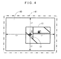
- the liquid crystal display 15 displays map information of the currently traveling place, map information of the vicinity of a destination (see FIG. 4 ), operation guidance, an operation menu, key guidance, a recommended route from the current position to the destination, guidance information along the recommended route, traffic information, news, a weather forecast, time, an e-mail, a television program, and/or the like.
- the speaker 16 outputs audio guidance, and/or the like for giving guidance on traveling along the recommended route based on an instruction from the navigation control unit 13.
- an example of the audio guidance to be given is "turn right at the ** intersection at 200 meters ahead.”
- the communication device 17 is a communication unit using a mobile phone network or the like for communicating with the map information distribution center and performs transmission/reception of updating map information of the latest version, or the like to/from the map information distribution center.
- the communication device 17 also receives traffic information including various information such as traffic congestion information and congestion status of a service area sent from the road traffic information center, or the like, in addition to the map information distribution center.
- the touch panel 18 is a transparent panel-like touch switch attached on a surface portion of the liquid crystal display 15.
- the touch panel 18 allows pressing of a button or a map displayed on the screen of the liquid crystal display 15 to input various instruction commands, perform follow-scrolling of the map image, and the like, as will be described later.
- the touch panel 18 may be an optical sensor liquid crystal-type touch panel, on which the screen of the liquid crystal display 15 is pressed directly.
- step (hereinafter abbreviated to S) 11 the CPU 41 performs processing to determine whether pressing of the touch panel 18 is started or not, that is, whether the touch panel 18 is pressed or not.
- step (S11: NO) the CPU 41 finishes this processing.
- the CPU 41 when pressing of the touch panel 18 is started (S11: YES), the CPU 41 proceeds to processing of S12.
- the CPU 41 reads from the navigation map information 26 map information of an area vertically and horizontally twice as large as a display screen of the liquid crystal display 15, the area having a center at a pressed coordinate position (hereinafter referred to as "touch coordinates") where the touch panel 18 is pressed.
- the CPU 41 stores a map image drawn based on the map information read from the navigation map information 26 in one of the first VRAM 42A and the second VRAM 42B, which is not currently used for display (which will be hereinafter described as the first VRAM 42A). Subsequently, the CPU 41 switches to the first VRAM 42A, to switch the display screen of the liquid crystal display 15 to a map image having a center at the touch coordinates and display this map image.
- the CPU 41 reads from the navigation map information 26 map information of an area vertically and horizontally twice as large as the display screen with a horizontal length L1 and a vertical length L2, the area having a center at the touch coordinates.
- the CPU 41 then stores a map image 60 drawn based on the map information read from the navigation map information 26 in the first VRAM 42A. Subsequently, the CPU 41 switches the display screen of the liquid crystal display 15 to the map image 60 having a center at the touch coordinates and displays this map image.
- the CPU 41 performs processing to determine whether the pressing of the touch panel 18 is released or not, that is, the pressing of the display screen of the liquid crystal display 15 is released or not.
- the CPU 41 proceeds to processing of S14.
- the CPU 41 performs follow-scrolling of the map image so that a point opposing the touch coordinates moves to follow this movement. Then the CPU 41 performs processing in S13 and thereafter again. It may be structured such that, during the follow-scrolling, after the map image is drawn first with rough image quality and displayed on the display screen, the map image is drawn once again with highly precise image quality in the same drawing range and displayed on the display screen. This enables to perform fast and highly accurate follow-scrolling.
- the CPU 41 performs the follow-scrolling of the map image 60 leftward so that, accompanying the movement of the touch coordinates of the index finger 67, the map image 60 moves following the touch coordinates.
- the follow-scrolling of the map image is performed following the touch coordinates in this manner, the touch position cannot be moved to the outside of the display screen.
- this scrolling takes place within the area of the map image (the area vertically and horizontally twice as large as the display screen with the horizontal length L1 and the vertical length L2, the area having a center at the initial touch coordinates) stored in the first VRAM 42A, and it is not necessary to newly draw the map image. Then the CPU 41 performs processing in S13 and thereafter again.
- the CPU 41 sets a scrolling direction and an initial speed of the map image based on a moving direction and a moving speed of the finger at the time when the pressing of the display screen is released. Specifically, the CPU 41 detects the touch coordinates of the touch panel 18 at every predetermined time (for example, at every 20 milliseconds), and stores touch coordinates of past several times (for example, past ten times) in the RAM 42. Then the CPU 41 calculates the moving direction and the moving speed of the finger on the display screen from the touch coordinates at the time when the pressing of the touch panel 18 is released and one previous set of touch coordinates before the pressing is released, sets them as the scrolling direction and the initial speed of a scrolling speed of the map image, respectively, and stores them in the RAM 42.
- the CPU 41 calculates the moving direction and the moving speed of the finger on the display screen from the touch coordinates at the time when the pressing of the touch panel 18 is released and one previous set of touch coordinates before the pressing is released, sets them as the scrolling direction and the initial speed of a
- the CPU 41 reads the initial speed from the RAM 42, and performs processing to determine whether or not this initial speed is equal to or higher than a predetermined speed, that is, whether or not the finger pressing the touch panel 18 is moved in the scrolling direction at the predetermined speed or higher. For example, when the display screen has a resolution of 800 x 600 dots, the CPU 41 determines whether or not the initial speed is equal to or higher than 300 dots/second.
- the moving speed of the finger on the display screen becomes lower than the predetermined speed, and thus scrolling of the map image 61 stops.
- the sub-processing "inertial scroll processing" performed by the CPU 41 in aforementioned S17 will be described based on FIG. 3 .
- a margin for preventing the map image from discontinuing when the follow-scrolling changes to inertial scrolling as illustrated in FIG. 4 , preferably there is stored in the first VRAM 42A a map image 61 that is obtained such that, to the map image 60 of the area vertically and horizontally twice as large as the display screen of the liquid crystal display 15, map information of an outside predetermined distance area is added as a margin across the entire circumference of a peripheral portion of the map image area.
- the map image drawn in the first VRAM 42A will be described as the map image 61 that includes the margin.
- the CPU 41 reads the scrolling direction of the map image from the RAM 42, and calculates a display area of the display screen at the time when the display area of the liquid crystal display 15 reaches an edge portion of the map image drawn in the first VRAM 42A while the currently displayed map image is scrolled in the scrolling direction.
- the CPU 41 then reads from the navigation map information 26 map information obtained such that, to map information of an area vertically and horizontally twice as large as the display screen, the area having a center at an intersection point between a peripheral edge portion of the calculated display area of the display screen and a straight line drawn from the touch coordinates to the scrolling direction side, map information of an outside predetermined distance area is added as a margin across the entire circumference of a peripheral portion of the area. Subsequently, the CPU 41 stores a map image drawn based on the map information read from the navigation map information 26 in one of the first VRAM 42A and the second VRAM 42B, which is not currently used for display, that is, the second VRAM 42B as an adjacent map image.
- FIG. 5 when the index finger 51 swipes in the rightward direction on the map image 61, the CPU 41 calculates a moved display area 71 of the display screen at the time when the display area of the liquid crystal displays 15 reaches a right edge portion of the area vertically and horizontally twice as large as the display screen, the area having a center at the touch coordinates in the map image 61.
- the CPU 41 reads from the navigation map information 26 map information obtained by adding a margin to map information of an area vertically and horizontally twice as large as the display screen with the horizontal length L1 and the vertical length L2, the area having a center at an intersection point between the moved display area 71 and a straight line drawn in the scrolling direction, that is, the rightward direction from the touch coordinates, the intersection point being, in other words, a middle point of a right side of the moved display area 71. Subsequently, the CPU 41 stores a map image drawn based on the map information read from the navigation map information 26 as an adjacent map image 62 in the second VRAM 42B.
- the CPU 41 reads the scrolling direction and the initial speed of the map image from the RAM 42, and performs the inertial scrolling of the map image at the initial speed as a scrolling speed in the read scrolling direction for a predetermined time (for example, 100 milliseconds).
- the CPU 41 reads the initial speed from the RAM 42, reduces a predetermined speed (for example, 30 dots/second) from the initial speed, and stores the result again as the initial speed in the RAM 42. That is, the CPU 41 decelerates the scrolling speed of the map image. Subsequently, in S114, the CPU 41 reads the scrolling speed from the RAM 42, and performs processing to determine whether the scrolling speed has become a stop speed or not. Specifically, the CPU 41 performs processing to determine whether the initial speed has become equal to or lower than 0 dot/second.
- a predetermined speed for example, 30 dots/second
- the CPU 41 performs processing to determine whether or not the range of the map displayed on the display screen of the liquid crystal display 15 has reached an outside area of the map image stored in the first VRAM 42A, that is, whether or not the display area of the display screen has reached the margin of the map image.
- the CPU 41 performs processing of S112 and thereafter again.
- the CPU 41 proceeds to processing of S116.
- the CPU 41 switches to the second VRAM 42B and displays the drawing range corresponding to the adjacent map image, and then performs processing of S111 and thereafter again.
- the CPU 41 switches from the map image 61 to the adjacent map image 62, displays the corresponding moved display area 71 of the adjacent map image 62, and then performs processing of S111 and thereafter again.
- the CPU 41 when the CPU 41 performs the follow-scrolling of the map image that is displayed following the movement of the touch coordinates, the CPU 41 may store, once in one of the first VRAM 42A and the second RAM 42B, which is not currently used for display, a map image drawn based on map information of an area vertically and horizontally twice as large as the display screen, the area having a center at a position on the map where pressing is detected first.
- a processing time for storing a map image needed for the follow-scrolling can be reduced, and the memory capacities of the first VRAM 42A and the second VRAM 42B storing a map image can be decreased. Since the map image stored in the first VRAM 42A or the second VRAM 42B includes a map image drawn based on the map information of an area vertically and horizontally twice as large as the display screen, the follow-scrolling can be performed securely until the touch coordinates reach an edge portion of the display screen irrespective of which position on the display screen is pressed first.
- map information of an outside predetermined distance area is added as a margin across the entire circumference of a peripheral portion of the area.
- the CPU 31 may be configured to store in above-described S12 the map image drawn based on map information of an area vertically and horizontally twice as large as the display screen of the liquid crystal display 15, the area having a center at the touch coordinates, in one of the first VRAM 42A and the second VRAM 42B, which is not currently used for display. This allows further reduction in processing time for storing a map image needed for performing the follow-scrolling.
- (B) For example, it is also possible to provide three or more storage areas of VRAM in the RAM 42. This allows more smooth display of the inertial scrolling by sequentially switching to an adjacent map image for display when the display area of the display screen reaches the margin of a map image when the inertial scrolling of the map image is performed.
Landscapes
- Engineering & Computer Science (AREA)
- Radar, Positioning & Navigation (AREA)
- Remote Sensing (AREA)
- Automation & Control Theory (AREA)
- Physics & Mathematics (AREA)
- General Physics & Mathematics (AREA)
- User Interface Of Digital Computer (AREA)
- Navigation (AREA)
- Instructional Devices (AREA)
- Controls And Circuits For Display Device (AREA)
Applications Claiming Priority (1)
| Application Number | Priority Date | Filing Date | Title |
|---|---|---|---|
| JP2010058630A JP2011191577A (ja) | 2010-03-16 | 2010-03-16 | 地図表示装置、地図表示方法及びプログラム |
Publications (1)
| Publication Number | Publication Date |
|---|---|
| EP2366973A2 true EP2366973A2 (fr) | 2011-09-21 |
Family
ID=44168433
Family Applications (1)
| Application Number | Title | Priority Date | Filing Date |
|---|---|---|---|
| EP11151586A Withdrawn EP2366973A2 (fr) | 2010-03-16 | 2011-01-20 | Appareil d'affichage de cartes, procédé d'affichage de cartes et programme |
Country Status (4)
| Country | Link |
|---|---|
| US (1) | US20110227948A1 (fr) |
| EP (1) | EP2366973A2 (fr) |
| JP (1) | JP2011191577A (fr) |
| CN (1) | CN102193723A (fr) |
Cited By (1)
| Publication number | Priority date | Publication date | Assignee | Title |
|---|---|---|---|---|
| CN109254718A (zh) * | 2012-08-30 | 2019-01-22 | 三星电子株式会社 | 提供导航信息的方法、电子设备和存储设备 |
Families Citing this family (13)
| Publication number | Priority date | Publication date | Assignee | Title |
|---|---|---|---|---|
| US20120293559A1 (en) * | 2010-02-23 | 2012-11-22 | Mitsubishi Electric Corporation | Map scrolling device |
| JP2012168790A (ja) * | 2011-02-15 | 2012-09-06 | Brother Ind Ltd | 表示プログラム、及び、表示装置 |
| KR101794000B1 (ko) * | 2011-06-13 | 2017-11-06 | 삼성전자주식회사 | 터치 스크린을 구비하는 기기에서 스크롤 장치 및 방법 |
| JP5770654B2 (ja) * | 2012-02-16 | 2015-08-26 | シャープ株式会社 | 画面表示装置、その制御方法、プログラム、およびコンピュータ読み取り可能な記録媒体 |
| US9965162B2 (en) | 2012-11-29 | 2018-05-08 | Facebook, Inc. | Scrolling across boundaries in a structured document |
| US10191643B2 (en) * | 2012-11-29 | 2019-01-29 | Facebook, Inc. | Using clamping to modify scrolling |
| CN104423849B (zh) * | 2013-08-19 | 2018-10-12 | 联想(北京)有限公司 | 一种信息处理方法、装置及电子设备 |
| CN103605424B (zh) * | 2013-11-01 | 2016-09-14 | 中国人民解放军信息工程大学 | 空天地一体化态势表达引擎及其带惯性的视点控制方法 |
| JP2015148991A (ja) * | 2014-02-07 | 2015-08-20 | ソニー株式会社 | 情報処理装置、情報処理方法及びプログラム |
| JP6235544B2 (ja) * | 2015-10-13 | 2017-11-22 | 株式会社スクウェア・エニックス | プログラム,コンピュータ装置,画面制御方法,及びシステム |
| US10891044B1 (en) * | 2016-10-25 | 2021-01-12 | Twitter, Inc. | Automatic positioning of content items in a scrolling display for optimal viewing of the items |
| JP6740898B2 (ja) * | 2016-12-28 | 2020-08-19 | カシオ計算機株式会社 | 地図記録装置、プログラム及び地図記録方法 |
| WO2019163503A1 (fr) * | 2018-02-22 | 2019-08-29 | 京セラ株式会社 | Dispositif électronique, procédé de commande et programme |
Citations (2)
| Publication number | Priority date | Publication date | Assignee | Title |
|---|---|---|---|---|
| JPH0310281A (ja) | 1989-06-07 | 1991-01-17 | Alpine Electron Inc | 地図描画方法 |
| JP2010058630A (ja) | 2008-09-03 | 2010-03-18 | Caterpillar Japan Ltd | 装軌式車両のリコイル装置 |
-
2010
- 2010-03-16 JP JP2010058630A patent/JP2011191577A/ja active Pending
- 2010-12-28 CN CN2010106225903A patent/CN102193723A/zh active Pending
-
2011
- 2011-01-20 EP EP11151586A patent/EP2366973A2/fr not_active Withdrawn
- 2011-01-21 US US13/011,236 patent/US20110227948A1/en not_active Abandoned
Patent Citations (2)
| Publication number | Priority date | Publication date | Assignee | Title |
|---|---|---|---|---|
| JPH0310281A (ja) | 1989-06-07 | 1991-01-17 | Alpine Electron Inc | 地図描画方法 |
| JP2010058630A (ja) | 2008-09-03 | 2010-03-18 | Caterpillar Japan Ltd | 装軌式車両のリコイル装置 |
Cited By (1)
| Publication number | Priority date | Publication date | Assignee | Title |
|---|---|---|---|---|
| CN109254718A (zh) * | 2012-08-30 | 2019-01-22 | 三星电子株式会社 | 提供导航信息的方法、电子设备和存储设备 |
Also Published As
| Publication number | Publication date |
|---|---|
| US20110227948A1 (en) | 2011-09-22 |
| CN102193723A (zh) | 2011-09-21 |
| JP2011191577A (ja) | 2011-09-29 |
Similar Documents
| Publication | Publication Date | Title |
|---|---|---|
| EP2366973A2 (fr) | Appareil d'affichage de cartes, procédé d'affichage de cartes et programme | |
| US9222796B2 (en) | Map display system, map display method, and computer-readable storage medium | |
| JP4502005B2 (ja) | ナビゲーション装置及びコンピュータプログラム | |
| US7925438B2 (en) | Method and apparatus for displaying route guidance list for navigation system | |
| EP2390774A2 (fr) | Dispositif d'affichage d'informations, procédé d'affichage d'informations et programme | |
| JP5347988B2 (ja) | ナビゲーション装置 | |
| EP2306155B1 (fr) | Dispositif de navigation avec selection d'icone par tactiles multiples | |
| US8520029B2 (en) | Image display device, image display method, and program | |
| WO2005121706A1 (fr) | Dispositif d’affichage de carte et méthode d’affichage de carte | |
| EP3040683A1 (fr) | Système et procédé de recherche d'itinéraire et programme informatique | |
| WO2009128496A1 (fr) | Dispositif de navigation | |
| JP2009058332A (ja) | ナビゲーション装置 | |
| JP2008180786A (ja) | ナビゲーションシステムおよびナビゲーション装置 | |
| JP4809900B2 (ja) | ナビゲーション装置、地図表示方法及び地図表示プログラム | |
| JP5328280B2 (ja) | ナビゲーション装置 | |
| JP2010091582A (ja) | ナビゲーション装置及びコンピュータプログラム | |
| JP4983576B2 (ja) | 施設情報表示装置、施設情報表示方法、施設情報表示プログラム | |
| JP4849237B2 (ja) | 車両用走行経路案内装置 | |
| JP2012133245A (ja) | 地図表示装置、地図表示方法及びコンピュータプログラム | |
| JP2007163310A (ja) | 情報表示装置、情報表示方法、情報表示プログラム、および記録媒体 | |
| JP4835494B2 (ja) | 地図表示装置 | |
| JP4970181B2 (ja) | 車載用情報端末、その制御方法及びその制御プログラム | |
| JP2008089483A (ja) | 車両用ナビゲーション装置 | |
| JP2012128100A (ja) | 情報表示装置、情報表示方法及びプログラム | |
| JP2011191541A (ja) | 地図表示装置、地図表示方法及びプログラム |
Legal Events
| Date | Code | Title | Description |
|---|---|---|---|
| PUAI | Public reference made under article 153(3) epc to a published international application that has entered the european phase |
Free format text: ORIGINAL CODE: 0009012 |
|
| AK | Designated contracting states |
Kind code of ref document: A2 Designated state(s): AL AT BE BG CH CY CZ DE DK EE ES FI FR GB GR HR HU IE IS IT LI LT LU LV MC MK MT NL NO PL PT RO RS SE SI SK SM TR |
|
| AX | Request for extension of the european patent |
Extension state: BA ME |
|
| STAA | Information on the status of an ep patent application or granted ep patent |
Free format text: STATUS: THE APPLICATION HAS BEEN WITHDRAWN |
|
| 18W | Application withdrawn |
Effective date: 20120405 |