EP2756332B1 - Procédé de sélection d'un satellite - Google Patents
Procédé de sélection d'un satellite Download PDFInfo
- Publication number
- EP2756332B1 EP2756332B1 EP12761585.4A EP12761585A EP2756332B1 EP 2756332 B1 EP2756332 B1 EP 2756332B1 EP 12761585 A EP12761585 A EP 12761585A EP 2756332 B1 EP2756332 B1 EP 2756332B1
- Authority
- EP
- European Patent Office
- Prior art keywords
- location data
- satellite
- vehicle
- measurement
- gnss
- Prior art date
- Legal status (The legal status is an assumption and is not a legal conclusion. Google has not performed a legal analysis and makes no representation as to the accuracy of the status listed.)
- Active
Links
Images

Classifications
-
- G—PHYSICS
- G01—MEASURING; TESTING
- G01S—RADIO DIRECTION-FINDING; RADIO NAVIGATION; DETERMINING DISTANCE OR VELOCITY BY USE OF RADIO WAVES; LOCATING OR PRESENCE-DETECTING BY USE OF THE REFLECTION OR RERADIATION OF RADIO WAVES; ANALOGOUS ARRANGEMENTS USING OTHER WAVES
- G01S19/00—Satellite radio beacon positioning systems; Determining position, velocity or attitude using signals transmitted by such systems
- G01S19/01—Satellite radio beacon positioning systems transmitting time-stamped messages, e.g. GPS [Global Positioning System], GLONASS [Global Orbiting Navigation Satellite System] or GALILEO
- G01S19/13—Receivers
- G01S19/24—Acquisition or tracking or demodulation of signals transmitted by the system
- G01S19/28—Satellite selection
-
- G—PHYSICS
- G01—MEASURING; TESTING
- G01S—RADIO DIRECTION-FINDING; RADIO NAVIGATION; DETERMINING DISTANCE OR VELOCITY BY USE OF RADIO WAVES; LOCATING OR PRESENCE-DETECTING BY USE OF THE REFLECTION OR RERADIATION OF RADIO WAVES; ANALOGOUS ARRANGEMENTS USING OTHER WAVES
- G01S19/00—Satellite radio beacon positioning systems; Determining position, velocity or attitude using signals transmitted by such systems
- G01S19/01—Satellite radio beacon positioning systems transmitting time-stamped messages, e.g. GPS [Global Positioning System], GLONASS [Global Orbiting Navigation Satellite System] or GALILEO
- G01S19/13—Receivers
- G01S19/22—Multipath-related issues
-
- G—PHYSICS
- G01—MEASURING; TESTING
- G01S—RADIO DIRECTION-FINDING; RADIO NAVIGATION; DETERMINING DISTANCE OR VELOCITY BY USE OF RADIO WAVES; LOCATING OR PRESENCE-DETECTING BY USE OF THE REFLECTION OR RERADIATION OF RADIO WAVES; ANALOGOUS ARRANGEMENTS USING OTHER WAVES
- G01S19/00—Satellite radio beacon positioning systems; Determining position, velocity or attitude using signals transmitted by such systems
- G01S19/01—Satellite radio beacon positioning systems transmitting time-stamped messages, e.g. GPS [Global Positioning System], GLONASS [Global Orbiting Navigation Satellite System] or GALILEO
- G01S19/13—Receivers
- G01S19/20—Integrity monitoring, fault detection or fault isolation of space segment
-
- G—PHYSICS
- G01—MEASURING; TESTING
- G01S—RADIO DIRECTION-FINDING; RADIO NAVIGATION; DETERMINING DISTANCE OR VELOCITY BY USE OF RADIO WAVES; LOCATING OR PRESENCE-DETECTING BY USE OF THE REFLECTION OR RERADIATION OF RADIO WAVES; ANALOGOUS ARRANGEMENTS USING OTHER WAVES
- G01S19/00—Satellite radio beacon positioning systems; Determining position, velocity or attitude using signals transmitted by such systems
- G01S19/38—Determining a navigation solution using signals transmitted by a satellite radio beacon positioning system
- G01S19/39—Determining a navigation solution using signals transmitted by a satellite radio beacon positioning system the satellite radio beacon positioning system transmitting time-stamped messages, e.g. GPS [Global Positioning System], GLONASS [Global Orbiting Navigation Satellite System] or GALILEO
- G01S19/52—Determining velocity
-
- G—PHYSICS
- G01—MEASURING; TESTING
- G01S—RADIO DIRECTION-FINDING; RADIO NAVIGATION; DETERMINING DISTANCE OR VELOCITY BY USE OF RADIO WAVES; LOCATING OR PRESENCE-DETECTING BY USE OF THE REFLECTION OR RERADIATION OF RADIO WAVES; ANALOGOUS ARRANGEMENTS USING OTHER WAVES
- G01S19/00—Satellite radio beacon positioning systems; Determining position, velocity or attitude using signals transmitted by such systems
- G01S19/01—Satellite radio beacon positioning systems transmitting time-stamped messages, e.g. GPS [Global Positioning System], GLONASS [Global Orbiting Navigation Satellite System] or GALILEO
- G01S19/13—Receivers
- G01S19/21—Interference related issues ; Issues related to cross-correlation, spoofing or other methods of denial of service
-
- G—PHYSICS
- G01—MEASURING; TESTING
- G01S—RADIO DIRECTION-FINDING; RADIO NAVIGATION; DETERMINING DISTANCE OR VELOCITY BY USE OF RADIO WAVES; LOCATING OR PRESENCE-DETECTING BY USE OF THE REFLECTION OR RERADIATION OF RADIO WAVES; ANALOGOUS ARRANGEMENTS USING OTHER WAVES
- G01S19/00—Satellite radio beacon positioning systems; Determining position, velocity or attitude using signals transmitted by such systems
- G01S19/01—Satellite radio beacon positioning systems transmitting time-stamped messages, e.g. GPS [Global Positioning System], GLONASS [Global Orbiting Navigation Satellite System] or GALILEO
- G01S19/13—Receivers
- G01S19/21—Interference related issues ; Issues related to cross-correlation, spoofing or other methods of denial of service
- G01S19/215—Interference related issues ; Issues related to cross-correlation, spoofing or other methods of denial of service issues related to spoofing
-
- G—PHYSICS
- G01—MEASURING; TESTING
- G01S—RADIO DIRECTION-FINDING; RADIO NAVIGATION; DETERMINING DISTANCE OR VELOCITY BY USE OF RADIO WAVES; LOCATING OR PRESENCE-DETECTING BY USE OF THE REFLECTION OR RERADIATION OF RADIO WAVES; ANALOGOUS ARRANGEMENTS USING OTHER WAVES
- G01S19/00—Satellite radio beacon positioning systems; Determining position, velocity or attitude using signals transmitted by such systems
- G01S19/38—Determining a navigation solution using signals transmitted by a satellite radio beacon positioning system
- G01S19/39—Determining a navigation solution using signals transmitted by a satellite radio beacon positioning system the satellite radio beacon positioning system transmitting time-stamped messages, e.g. GPS [Global Positioning System], GLONASS [Global Orbiting Navigation Satellite System] or GALILEO
- G01S19/42—Determining position
- G01S19/51—Relative positioning
Definitions
- the invention relates to a method for selecting a satellite that is designed to send a GNSS signal to a vehicle, a control device for carrying out the method, and a vehicle with the control device.
- WO 2010/073113 A1 relates to a method in which, based on a received GNSS signal and based on speed sensor data, reference data is determined and compared with measurement data in order to assess and characterize the usability of the GNSS signal. A threshold value is checked during the comparison, which depends on the reference data, the measurement data and the receiver clock error.
- the US2010328150A1 relates to a navigation system for detecting errors in Doppler frequencies of a plurality of satellite signals measured by the navigation system, the navigation system including an offset calculator for calculating offsets of the Doppler frequencies of the satellite signals during a predetermined period of time and for calculating an average value of the offsets.
- the navigation system also includes an error detection unit that is coupled to the offset computer. The error detection unit compares the offsets of the Doppler frequencies of the satellite signals with the average value of the offsets and determines whether the satellite signals are unavailable according to corresponding comparison results.
- WO 98/39722 A1 provides a real-time assessment of the integrity of the location solution and navigation sensors used to support an emergency call system that integrates location and cellular technology.
- This integrity information is used via a warning light displayed to the driver to indicate when the system is not supporting emergency calls with the required accuracy.
- At least two types of alerts are generated and provided to the user, the first being an indication that the position accuracy no longer supports an emergency call, the second being an indication that a sensor or subsystem of the emergency call location system is malfunctioning, and so on should be serviced as soon as possible, and such a malfunction could result in eventual system failure.
- the method specified is based on the consideration that position information of the vehicle could be derived from the GNSS signal. Taking this consideration as a basis, however, it is recognized within the scope of the specified method that the GNSS signal could pass through various sources of interference before it is received at the vehicle, which could introduce noise into the GNSS signal so that it no longer indicates the true position of the vehicle. Such sources of interference could represent multipath reception, shadowing or reflections.
- the idea of the specified method for the GNSS signal is to define an expected value from which a reference for the quality of the GNSS signal can be derived with sufficient accuracy. If the deviation between the GNSS signal and the expected value used as a reference is sufficiently small, then the satellite is selected as the source for the GNSS signal.
- a difference between the measurement position data and the reference position data is formed in order to compare the measurement position data and the reference position data.
- This development is based on the consideration that although the comparison could be carried out on the basis of any filter, the difference between the two position data is immediately preceded by their deviation from one another, which the GNSS signal describes statistically and thus allows an immediate evaluation of its quality.
- a maximum permissible error between the measurement position data and the reference position data is to be allowed as a predetermined condition, which in turn represents a quality limit when selecting the satellite.
- the maximum allowable error depends on a standard deviation calculated based on a sum of a reference variance for the reference location data and a measurement variance for the measurement location data. This development is based on the consideration that two statistical values are included here at the same time when selecting the satellite.
- the reference value could be determined iteratively, with its quality increasing with increasing iteration steps. However, this means that the reference value itself can initially be very noisy and error-prone, which is why it would not be practical at this point in time to select a GNSS signal with a very high quality.
- the maximum permissible error and thus the permissible deviation as a function of the variances and thus the noise of the two position data, the maximum permissible error between the position data and the noise of the position data itself are correlated during the selection. This ensures that the noise of the satellite to be selected is adjusted to the deviation between the expected value and the measured value represented by the GNSS signal is.
- the maximum permissible error corresponds to a multiple of the standard deviation in such a way that the probability that the measurement position data will fall below a predetermined threshold value in a scatter interval dependent on the standard deviation. In this way it is ensured that due to the unavoidable scattering of the deviations between the reference position data, ie the expected value, and the measurement position data, ie the measured value, an actually suitable satellite is not accidentally not selected.
- the method specified is based on the consideration that the selection of the satellite could already be carried out on the basis of hard decision-making bases, because the vehicle that uses the GNSS signal has certain physical characteristics is subject to boundary conditions. For example, the vehicle must not accelerate at will and cannot drive at any speed. These physical boundary conditions can be used as a basis for selecting the satellite without the need for further comparison measurements to check the quality of the GNSS signal.
- the predetermined condition may preferably be a physical constraint to which the vehicle is subjected.
- the physical boundary condition can particularly preferably be a limit acceleration and/or a limit speed for the vehicle.
- the measurement location data can include a speed and/or an acceleration, for example, which is derived from the GNSS signal. In this way, it can be checked directly whether the aforementioned physical boundary conditions are met or not.
- the method specified is based on the consideration that the three satellites with the satellite to be selected have a known position in relation to one another. Based on this known position, the vehicle must also move in an expected manner with respect to these three satellites. This movement to be expected can be used as a basis for deciding on the selection of the GNSS signal and thus the satellite to be selected.
- the position of the three satellites includes position information relative to one another.
- the GNSS signals of all three GNSS satellites would have to be falsified in exactly the same way by shadowing, multiple reflections, and so on, which can be virtually ruled out due to the completely different signal paths . Therefore, the specified method provides a very reliable basis for the selection of a satellite.
- the comparison of the position of the three satellites with respect to one another and the measurement position data includes a comparison of the distances of the vehicle from the three satellites.
- This development is based on the consideration that the GNSS signals of the three satellites could be examined for possible contradictions based on the position of the satellites relative to one another. For example, if all three satellites are in front of the vehicle viewed in the direction of travel of the vehicle, then all three distances must decrease.
- trigonometric considerations can be used to determine how quickly individual distances between the vehicle and the corresponding satellite may decrease. The distances between the satellites can be derived from information transmitted by the satellites.
- the method specified is based on the consideration that the distance of the vehicle from the satellite and the relative speed of the vehicle with respect to the satellite are dependent on one another, ie are correlated. Furthermore, the specified method is based on the consideration that the relative speed from the GNSS signal could be detected, for example, based on Doppler effects, while the distance of the vehicle from the satellite, for example, based on a transit time of the GNSS signal and thus metrologically independent of detecting the relative speed could become.
- the idea of the specified method is that the two measurements must nevertheless match one another, since the measured variables to be recorded, ie the relative speed and the distance, are dependent on one another.
- the comparison can be based on any difference or other filtering.
- the basis for the decision to select the satellite with a minimum computing time is immediately apparent from a difference formation.
- the measured position data of the vehicle and the reference position data of the vehicle can each have a distance from the satellite and/or a relative velocity in the line of sight of the satellite.
- the method specified according to the last aspect of the invention selects the satellite based on an analysis of the measurement position data in itself, taking advantage of the fact that the GNSS signal transmits the measurement position data with principles that can be measured in two different ways.
- the distance from the satellite and/or the relative speed in the viewing direction of the satellite can be determined from a code measurement and a phase measurement of the GNSS signal.
- a Global Positioning System signal GPS signal for short
- GNSS signal for example Signal, GLONASS signal for short, or a Galileo signal can be used.
- GLONASS signal for short
- Galileo signal can be used. This would provide an alternative or additional comparison variable for the longitudinal vehicle speed based on which the information content of the tire radius to be recorded could be improved.
- the GNSS signal allows, for example, network participants in an on-board network of the vehicle, such as sensors, to be time-synchronized with correspondingly high precision due to its highly precise time stamp. Such synchronization is currently the focus of current developments in Car2X communication, i.e. the exchange of data from one vehicle to other vehicles or Systems in the environment, such as traffic lights or other infrastructure components.
- the information must be provided in real time.
- the information can be provided with a highly precise time stamp, for example, which is linked to the information by the respective network participant.
- this time stamp must be correspondingly highly accurate, which is ensured by selecting an uncorrupted GNSS signal.
- the reference position data are dependent on vehicle dynamics data and/or odometry data of the vehicle.
- This development is based on the consideration that the reference position data can be made more precise based on the GNSS signal, for example in a fusion filter. This could be done, for example, by comparing the reference position data with the GNSS signal itself or with position data derived from the GNSS signal, such as the measurement position data, in an observer. Any filter that allows analog or digital status monitoring of the vehicle can fall under such an observer. For example, a Luenberger observer can be used. If the noise is to be taken into account, a Kalman filter could be considered.
- the shape of the noise should also be taken into account
- a particle filter could be used that has a basic set of available noise scenarios and selects the noise scenario to be taken into account in the elimination, for example by means of a Monte Carlo simulation.
- the observer is preferably a Kalman filter that delivers an optimal result in terms of the computing resources it requires. As a result of the observation, the reference position data become more and more precise over time and thus also allow more and more precise GNSS signals to be selected.
- a control device comprising a GNSS receiver, a fusion sensor and at least one further sensor is set up to carry out one of the specified methods.
- the specified device has a memory and a processor.
- a specified method is stored in the memory in the form of a computer program and the processor is provided for executing the method when the computer program is loaded from the memory into the processor.
- a computer program comprises program code means in order to carry out all the steps of one of the specified methods when the computer program is run on a computer or one of the specified devices.
- a computer program product contains a program code which is stored on a computer-readable data medium and which, when it is executed on a data processing device, carries out one of the specified methods.
- a vehicle includes a specified control device.
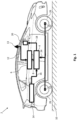
- the fusion sensor 4 receives position data 8 of the vehicle 2 via a GNSS receiver 6 known per se, which data include an absolute position of the vehicle 2 on a roadway 10 .
- the position data 8 from the GNSS receiver 6 also includes a speed of the vehicle 2.
- the position data 8 from the GNSS receiver 6 are generated in a manner known to those skilled in the art from a GNSS signal 12 in the GNSS -Receiver 6 derived, which is received via a GNSS antenna 13 and is therefore called GNSS position data 8 below.
- GNSS position data 8 For details, reference is made to the relevant specialist literature.
- the fusion sensor 4 is designed, in a manner yet to be described, to increase the information content of the GNSS position data 8 derived from the GNSS signal 12 .
- this is necessary because the GNSS signal 12 has a very high signal/noise band spacing and can therefore be very imprecise.
- the GNSS signal 12 is not always available.
- the vehicle 2 has an inertial sensor 14 for this purpose, which records driving dynamics data 16 of the vehicle 2 .
- this includes a longitudinal acceleration, a lateral acceleration and a vertical acceleration and a roll rate, a pitch rate and a yaw rate of the vehicle 2.
- This driving dynamics data 16 is used in the present embodiment to increase the information content of the GNSS position data 8 and, for example, the position and the To specify the speed of the vehicle 2 on the lane 10.
- the more precise location data 18 can then be used by a navigation device 20 even if the GNSS signal 12 is not available at all, for example under a tunnel.
- wheel speed sensors 22 can optionally be used in the present embodiment, which detect the wheel speeds 24 of the individual wheels 26 of the vehicle 2.
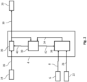
- the fusion sensor 4 goes the in 1 already mentioned measurement data.
- the fusion sensor 4 is intended to output the precise position data 18 .
- the basic idea for this is to compare the information from the GNSS position data 8 with the driving dynamics data 16 from the inertial sensor 14 in a filter 30 and thus to increase a signal/noise band spacing in the position data 8 of the GNSS receiver 6 or in the vehicle dynamics data 16 from the inertial sensor 14 .
- the filter can be designed as desired, but a Kalman filter solves this task most effectively with a comparatively low demand for computing resources. Therefore, the filter 30 shall preferably be a Kalman filter 30 hereinafter.
- the more precise position data 18 of the vehicle 2 and the comparative position data 34 of the vehicle 2 enter the Kalman filter 30 .
- the precise location data 18 are in the present embodiment in an example from the DE 10 2006 029 148 A1 known strapdown algorithm 36 generated from the driving dynamics data 16. They contain precise position information about the vehicle, but also other position data about the vehicle 2, such as its speed, its acceleration and its heading.
- the comparison location data 34 is obtained from a model 38 of the vehicle 2 which is initially fed with the GNSS location data 8 from the GNSS receiver 6 . From these GNSS position data 8, the comparison position data 34 are then determined in the model 38, which contain the same information as the more precise position data 18. The more precise position data 18 and the comparison position data 34 differ only in their values.
- the Kalman filter 30 calculates an error budget based on the more precise location data 18 and the comparative location data 34 40 for the more precise position data 18 and an error budget 42 for the comparison position data 34.
- An error budget is to be understood below as a total error in a signal, which is made up of various individual errors during the detection and transmission of the signal.
- a corresponding error budget can be made up of errors in the satellite orbit, the satellite clock, the remaining refraction effects and errors in the GNSS receiver 6 .
- the error budget 40 of the more precise location data 18 and the error budget 42 of the comparison location data 34 are then supplied according to the strapdown algorithm 36 and the model 38 for correcting the more precise location data 18 or the comparison location data 34 . This means that the precise location data 18 and the comparison location data 34 are iteratively corrected for their errors.
- the GNSS receiver 6 receives the GNSS signal 12 from one in the 3 GNSS satellites 44 shown.
- the GNSS signal 12 emitted by this GNSS satellite 44 can be more or less noisy, which is why the model 38 in the present embodiment has been expanded to include a function that is based on the GNSS signal 12 itself or on the basis evaluates GNSS position data 8 derived from the GNSS signal 12 and then uses the GNSS satellite 44 as a source based on the evaluation selects 12 for the GNSS signal.
- the vehicle 2 moves at a speed 46 and an acceleration 48 over the road 10. It should be assumed that the vehicle 2 brakes, so that the speed 46 and the acceleration 48 are in opposite directions.
- the speed 46 and the acceleration 48 can be determined from the GNSS signal 12 .
- the result of the differentiated phase measurement is a line-of-sight speed 50 which, in a manner known to those skilled in the art, is divided into the speed 46 and the acceleration 48 can be converted.
- the position of the vehicle can also be taken into account based on a code measurement, from which a distance 52 between the vehicle 2 and the satellite 44 is detected via a runtime detection of the GNSS signal 12, from which the speed is also calculated in a manner known to those skilled in the art 46 and the acceleration 48 can be calculated.
- the first of the four methods is described below:
- the core idea of the first method is that the speed 46 and the acceleration 48 must meet certain physical boundary conditions that they must not violate. This method is not part of the invention.
- the second method is described below: The second method is based on the consideration that a viewing speed 50, So the movement of the vehicle in the direction of the satellite, and a distance 52 to the satellite 44 can be detected directly.
- the visual velocity 50 and the distance 52 can be reconstructed based on the more precise position data 18 using alternative measurement principles, so that the visual velocity and distance to the satellite 44 derived from the GNSS signal 12 can be used as expected values for the visual velocity 50 transmitted with the GNSS signal 12 and distance 52 can be viewed.
- the core idea of the second method is now that deviations between the expected values and the corresponding information from the GNSS signal 12 must match the overall noise, that is to say that a deviation that can be calculated using the overall noise corresponds to the aforementioned actual deviation.
- the measurement noise ⁇ GNSS of the viewing speed 50 from the GNSS signal and an uncertainty about the more precise position data 18 as well as the uncertainty of all other measuring data entering the reconstructed viewing speed 50 and thus the measurement noise ⁇ Rek of the expected value add up to a total measurement noise ⁇ Meas ⁇ GNSS + ⁇ Rek .
- a deviation ⁇ can be determined between the viewing speed 50 and the reconstructed viewing speed, ie the expected value.
- a multiple of the standard deviation ⁇ Stand can be used as the threshold for the deviation ⁇ , with the multiple being able to be based on the desired spread for the selection.
- the basic idea of the fourth method is that the position of the satellite 44 and other satellites 54, 56 relative to one another and from the perspective of the vehicle can be determined independently of the viewing speed 50 and the distance 52, for example using information transmitted with the GNSS signal 12 become.
- the viewing speed 50 and the distance 52 from the individual satellites 44, 54, 56 cannot change in any way. For example, if all the satellites are in front of the vehicle 2 in the direction of travel 46, then all the distances 52 to the individual satellites 44, 54, 56 would have to become correspondingly smaller.
- this can be carried out, for example, via a trigonometric comparison. If the distances 58 between the satellites are known, and the distances of the vehicle 2 to at least two of the satellites 54, 56, then the distance 52 is overdetermined because it can be reconstructed from the previous information. Nevertheless, the reconstructed distance must match the actual distance 52, then the quality of the GNSS signal 12 from the satellite 44 can be assumed to be sufficient for the fusion sensor 4.
- an overdetermined system of equations can be set up mathematically via known trigonometric dependencies of the satellites 44, 54, 56 and the vehicle 2 to one another that must be able to be resolved without contradiction.
- the advantage of this system of equations is that the contradiction can be localized and thus assigned to a specific satellite 44, 54, 56, so that the corresponding satellite 44, 54, 56 and thus its GNSS signal 12 can be sorted out.
- the line-of-sight speed 50 and the distance 52 between the vehicle 2 and the satellite 44 are recorded using different measurement methods (carrier phase measurement and code measurement). They still have to match each other. That is, when the distance 52 is derived in time, the line-of-sight velocity 50 must result. Otherwise there is an error which can cause the satellite 44 to be discarded.
- the methods for selecting the satellite 44 are preferably carried out in the specified order, because the precision checked by the specified methods on the one hand and the precision for carrying out the specified method on the other hand increase from the first to the fourth method. It is therefore computationally unfavorable, from the physical In terms of boundary conditions, completely implausible satellites that can already be sorted out with the first method should be included in the equation system of the third method.
Landscapes
- Engineering & Computer Science (AREA)
- Radar, Positioning & Navigation (AREA)
- Remote Sensing (AREA)
- Computer Networks & Wireless Communication (AREA)
- Physics & Mathematics (AREA)
- General Physics & Mathematics (AREA)
- Computer Security & Cryptography (AREA)
- Position Fixing By Use Of Radio Waves (AREA)
- Navigation (AREA)
Claims (6)
- Procédé pour sélectionner un satellite (44), lequel est configuré pour envoyer à un véhicule (2) un signal du système mondial de navigation par satellite, appelé ci-après signal GNSS (12), comprenant :- mesure de données de position de mesure (50, 52) du véhicule par rapport au satellite (44) en se basant sur le signal GNSS (12),- détermination de données de position de référence du véhicule (2) redondantes avec les données de position de mesure (50, 52) déterminées en se basant sur le signal GNSS (12), lesquelles sont spécifiées comme les valeurs attendues des données de position de mesure (50, 52) ; et- sélection du satellite (44) lorsqu'une comparaison des données de position de mesure (50, 52) et des données de position de référence satisfait à une condition prédéterminée, la condition prédéterminée étant une erreur maximale admissible (µStan) entre les données de position de mesure (50, 52) et des données de position de référence,caractérisé en ce que l'erreur maximale admissible (µStan) dépend d'un écart-type qui est calculé en se basant sur une somme d'une variance de référence (σRek) pour les données de position de référence et d'une variance de mesure (σGNSS) pour les données de position de mesure (50, 52), l'erreur maximale admissible (µStan) correspondant à un multiple de l'écart-type de telle sorte qu'une probabilité pour que les données de position de mesure (50, 52) se trouvent à l'intérieur d'un intervalle de dispersion dépendant de l'écart-type est inférieure à une valeur de seuil prédéterminée,
- Procédé selon la revendication 1, une différence (µ) entre les données de position de mesure (50, 52) et les données de position de référence étant calculée pour la comparaison des données de position de mesure (50, 52) et des données de position de référence,
- Procédé selon l'une des revendications précédentes, les données de position de mesure (50, 52) du véhicule (2) et les données de référence du véhicule (2) comprenant respectivement une distance (52) par rapport au satellite (44) et/ou une vitesse relative (50) dans la direction de visibilité du satellite (44).
- Procédé selon la revendication 3, la distance (52) par rapport au satellite (44) et/ou la vitesse relative (50) dans la direction de visibilité du satellite (44) étant déterminées en conséquence à partir d'une mesure de code et d'une mesure de phase du signal GNSS (12),
- Procédé selon l'une des revendications précédentes, les données de position de référence étant dépendantes de données de dynamique de conduite et/ou de données odométriques du véhicule.
- Dispositif de commande (4, 6, 14), comprenant un récepteur GNSS (6), un capteur de fusion (4) et au moins un capteur supplémentaire (14), qui est conçu pour mettre en oeuvre un procédé selon l'une des revendications précédentes,
Applications Claiming Priority (5)
| Application Number | Priority Date | Filing Date | Title |
|---|---|---|---|
| DE102011082539 | 2011-09-12 | ||
| DE102011082534 | 2011-09-12 | ||
| DE102011086710 | 2011-11-21 | ||
| DE102012207297 | 2012-05-02 | ||
| PCT/EP2012/067866 WO2013037844A2 (fr) | 2011-09-12 | 2012-09-12 | Procédé de sélection d'un satellite |
Publications (2)
| Publication Number | Publication Date |
|---|---|
| EP2756332A2 EP2756332A2 (fr) | 2014-07-23 |
| EP2756332B1 true EP2756332B1 (fr) | 2023-05-31 |
Family
ID=46880695
Family Applications (1)
| Application Number | Title | Priority Date | Filing Date |
|---|---|---|---|
| EP12761585.4A Active EP2756332B1 (fr) | 2011-09-12 | 2012-09-12 | Procédé de sélection d'un satellite |
Country Status (5)
| Country | Link |
|---|---|
| US (2) | US9903956B2 (fr) |
| EP (1) | EP2756332B1 (fr) |
| KR (1) | KR20140057662A (fr) |
| DE (1) | DE102012216211A1 (fr) |
| WO (1) | WO2013037844A2 (fr) |
Families Citing this family (22)
| Publication number | Priority date | Publication date | Assignee | Title |
|---|---|---|---|---|
| CN103322999A (zh) * | 2013-05-24 | 2013-09-25 | 哈尔滨工程大学 | 一种适用于多艇导航的保留历史状态的信息滤波算法 |
| EP2816374B1 (fr) * | 2013-06-20 | 2016-05-25 | Intel Corporation | Positionnement de véhicule dans des environnements à forte réflexion |
| DE102013224917A1 (de) | 2013-12-04 | 2015-06-11 | Continental Teves Ag & Co. Ohg | Verfahren zum Erfassen einer die Aufmerksamkeit eines Fahrers beschreibenden Aufmerksamkeitsgröße |
| JP6312304B2 (ja) * | 2014-01-28 | 2018-04-18 | 三菱重工機械システム株式会社 | 位置測定方法、自己位置測定装置及び車載器 |
| DE102014211164A1 (de) | 2014-06-11 | 2015-12-17 | Continental Teves Ag & Co. Ohg | Verfahren und System zur Anpassung eines Navigationssystems |
| DE102014211176A1 (de) | 2014-06-11 | 2015-12-17 | Continental Teves Ag & Co. Ohg | Verfahren und System zur Korrektur von Messdaten und/oder Navigationsdaten eines Sensorbasissystems |
| DE102014211168A1 (de) * | 2014-06-11 | 2015-12-17 | Continental Teves Ag & Co. Ohg | Verfahren und System zur Verifizierung von Messdaten |
| DE102014211171A1 (de) | 2014-06-11 | 2015-12-17 | Continental Teves Ag & Co. Ohg | Verfahren und System zur Anpassung eines Navigationssystems |
| DE102014211175A1 (de) | 2014-06-11 | 2015-12-17 | Continental Teves Ag & Co. Ohg | Verfahren und System zur Initialisierung eines Sensorfusionssystems |
| DE102014013209B4 (de) | 2014-09-06 | 2016-06-09 | Audi Ag | Verfahren zur Bewertung eines Satellitensignals in einem globalen Navigationssatellitensystem im Hinblick auf einen Mehrwegefehler, Empfänger für ein globales Navigationssatellitensystem und Kraftfahrzeug |
| DE102015217626A1 (de) | 2014-09-24 | 2016-03-24 | Continental Teves Ag & Co. Ohg | GNSS-Lokalisierung durch Vor- und Zurückschreiben der Position |
| WO2016045931A2 (fr) | 2014-09-24 | 2016-03-31 | Continental Teves Ag & Co. Ohg | Concept de création d'images intermédaires (key-inbetween) pour m2xpro |
| DE102014219389A1 (de) | 2014-09-25 | 2016-03-31 | Continental Teves Ag & Co. Ohg | Koppelnavigation basierend auf Landmarken |
| DE102016201980A1 (de) | 2015-11-12 | 2017-05-18 | Continental Teves Ag & Co. Ohg | System zum Plausibilisieren von Satellitensignalen globaler Navigationssysteme |
| EP3236209B1 (fr) | 2016-04-19 | 2021-06-09 | Honda Research Institute Europe GmbH | Système de navigation et procédé de correction d'erreur |
| CN107884794A (zh) * | 2016-09-29 | 2018-04-06 | 上海华测导航技术股份有限公司 | 一种保留指定数据量的智能差分数据筛选方法 |
| DE102016224804A1 (de) | 2016-12-13 | 2018-06-14 | Bayerische Motoren Werke Aktiengesellschaft | Verfahren zur Bestimmung der Position einer Ladestation zur drahtlosen Übertragung von elektrischer Energie an ein Fahrzeug |
| US11035959B1 (en) * | 2017-04-19 | 2021-06-15 | Amazon Technologies, Inc. | Selection of satellites for global positioning system |
| DE102017222290A1 (de) | 2017-12-08 | 2019-06-13 | Continental Teves Ag & Co. Ohg | Verfahren zum Bestimmen von Korrekturwerten, Verfahren zum Bestimmen einer Position eines Kraftfahrzeugs, elektronische Steuerungsvorrichtung und Speichermedium |
| CN111319573B (zh) * | 2020-03-06 | 2021-11-09 | 广州驾悦信息科技有限公司 | 一种驾校高精模拟嵌入式系统 |
| KR20220017264A (ko) * | 2020-08-04 | 2022-02-11 | 삼성전자주식회사 | Gnss에 기초한 이동체의 이동 위치 보정 방법 및 장치. |
| FR3120133B1 (fr) * | 2021-02-19 | 2023-03-17 | Safran Electronics & Defense | Navigation lors d'une opération de leurrage d'un récepteur de signaux satellitaires |
Citations (1)
| Publication number | Priority date | Publication date | Assignee | Title |
|---|---|---|---|---|
| WO1998039722A1 (fr) * | 1997-03-03 | 1998-09-11 | Motorola Inc. | Procede et appareil pour produire une indication de la perte de l'integrite de positionnement dans des systemes d'appel d'urgence |
Family Cites Families (25)
| Publication number | Priority date | Publication date | Assignee | Title |
|---|---|---|---|---|
| US5323152A (en) * | 1992-04-15 | 1994-06-21 | Sumitomo Electric Industries, Ltd. | Apparatus for detecting the position of a vehicle |
| US5563608A (en) * | 1993-07-27 | 1996-10-08 | Matsushita Electric Industrial Co., Ltd. | Position measuring system and method therefor |
| JPH0743446A (ja) | 1993-08-02 | 1995-02-14 | Aisin Seiki Co Ltd | Gps衛星デ−タの検証装置 |
| US5862511A (en) * | 1995-12-28 | 1999-01-19 | Magellan Dis, Inc. | Vehicle navigation system and method |
| US5969672A (en) | 1998-07-17 | 1999-10-19 | Honeywell Inc. | GPS signal fault isolation monitor |
| JP2001264409A (ja) | 2000-03-21 | 2001-09-26 | Clarion Co Ltd | カーナビゲーション装置におけるマルチパス判定方法 |
| FR2866423B1 (fr) | 2004-02-13 | 2006-05-05 | Thales Sa | Dispositif de surveillance de l'integrite des informations delivrees par un systeme hybride ins/gnss |
| WO2005081010A1 (fr) * | 2004-02-18 | 2005-09-01 | Telefonaktiebolaget Lm Ericsson (Publ) | Procedes et systemes relatifs au positionnement par satellites |
| US7436355B2 (en) * | 2006-04-18 | 2008-10-14 | Andrew Corporation | Method and apparatus for geolocation determination |
| DE102006029148B4 (de) | 2006-06-24 | 2010-08-05 | Lfk-Lenkflugkörpersysteme Gmbh | Verfahren zur Überprüfung einer inertialen Messeinheit von Fahrzeugen, insbesondere von Luftfahrzeugen, im stationären Zustand |
| US7835863B2 (en) * | 2007-04-18 | 2010-11-16 | Mitac International Corporation | Method and system for navigation using GPS velocity vector |
| JP2008298607A (ja) * | 2007-05-31 | 2008-12-11 | Toshiba Corp | Gps受信装置 |
| DE112008002434B4 (de) * | 2007-09-10 | 2013-07-11 | Mitsubishi Electric Corp. | Navigationsausrüstung |
| US7821454B2 (en) * | 2007-11-20 | 2010-10-26 | Sirf Technology, Inc. | Systems and methods for detecting GPS measurement errors |
| JP4655139B2 (ja) * | 2008-11-19 | 2011-03-23 | トヨタ自動車株式会社 | 移動体位置測位装置 |
| JP2010151725A (ja) | 2008-12-26 | 2010-07-08 | Toyota Motor Corp | Gnss受信装置及び測位方法 |
| CN101937073B (zh) | 2009-06-30 | 2012-11-28 | 凹凸电子(武汉)有限公司 | Gps卫星的载波频率检测方法和装置及gps接收机 |
| JP5352422B2 (ja) * | 2009-10-30 | 2013-11-27 | 株式会社豊田中央研究所 | 測位装置及びプログラム |
| DE102010063984A1 (de) | 2010-02-11 | 2011-08-11 | Continental Teves AG & Co. OHG, 60488 | Fahrzeug-Sensor-Knoten |
| GB2487347A (en) * | 2011-01-05 | 2012-07-25 | Cambridge Silicon Radio Ltd | Reference satellite |
| GB201100114D0 (en) * | 2011-01-05 | 2011-02-16 | Cambridge Silicon Radio Ltd | Determing positiion |
| JP6069840B2 (ja) * | 2012-02-06 | 2017-02-01 | セイコーエプソン株式会社 | 移動速度算出方法及び移動速度算出装置 |
| US9322926B2 (en) * | 2012-03-30 | 2016-04-26 | Qualcomm Technologies International, Ltd. | Method and apparatus for synchronization and precise time computation for GNSS receivers |
| WO2015159563A1 (fr) * | 2014-04-18 | 2015-10-22 | 三菱電機株式会社 | Dispositif de mesure de position et procédé de mesure de position |
| JP7006080B2 (ja) * | 2017-09-25 | 2022-01-24 | カシオ計算機株式会社 | 移動状態判別装置、電子時計、移動状態判別方法及びプログラム |
-
2012
- 2012-09-12 EP EP12761585.4A patent/EP2756332B1/fr active Active
- 2012-09-12 US US14/344,440 patent/US9903956B2/en active Active
- 2012-09-12 DE DE102012216211A patent/DE102012216211A1/de not_active Withdrawn
- 2012-09-12 WO PCT/EP2012/067866 patent/WO2013037844A2/fr not_active Ceased
- 2012-09-12 KR KR1020147009713A patent/KR20140057662A/ko not_active Withdrawn
-
2017
- 2017-11-17 US US15/815,839 patent/US10830901B2/en active Active
Patent Citations (1)
| Publication number | Priority date | Publication date | Assignee | Title |
|---|---|---|---|---|
| WO1998039722A1 (fr) * | 1997-03-03 | 1998-09-11 | Motorola Inc. | Procede et appareil pour produire une indication de la perte de l'integrite de positionnement dans des systemes d'appel d'urgence |
Also Published As
| Publication number | Publication date |
|---|---|
| EP2756332A2 (fr) | 2014-07-23 |
| US20180203128A1 (en) | 2018-07-19 |
| KR20140057662A (ko) | 2014-05-13 |
| DE102012216211A1 (de) | 2013-03-14 |
| WO2013037844A2 (fr) | 2013-03-21 |
| US10830901B2 (en) | 2020-11-10 |
| US9903956B2 (en) | 2018-02-27 |
| WO2013037844A3 (fr) | 2013-06-20 |
| US20140333479A1 (en) | 2014-11-13 |
| CN103797380A (zh) | 2014-05-14 |
Similar Documents
| Publication | Publication Date | Title |
|---|---|---|
| DE102012216211A1 (de) | Verfahren zum Auswählen eines Satelliten | |
| DE102007041121B4 (de) | Verfahren und Vorrichtung zum Verarbeiten von Sensordaten für ein Fahrerassistenzsystem eines Fahrzeugs | |
| DE102019206021A1 (de) | Verfahren zur Erkennung einer Funktionsfähigkeit eines Umgebungssensors, Steuergerät und Fahrzeug | |
| EP3155454B1 (fr) | Procédé et système d'adaptation d'un système de navigation | |
| EP2936205A2 (fr) | Procédé pour fournir un signal gnss | |
| EP2051093B1 (fr) | Procédé et dispositif destinés à la surveillance de l'intégrité de signaux de navigation par satellite | |
| DE102010011982A1 (de) | Verfahren zum rechnergestützten Erstellen und/oder Aktualisieren einer Referenzkarte für eine satellitengestützte Ortung eines Objekts | |
| DE102012212673A1 (de) | Verfahren für das Detektieren des Ortes eines gegenüberliegenden Fahrzeugs, wobei GPS-Information benutzt wird | |
| DE102012216205A1 (de) | Fusion von Chassissensordaten mit Fahrdynamikdaten | |
| DE102015226650B4 (de) | Verfahren und Vorrichtung zum anonymisierten Übermitteln eines ersten Werts zumindest eines Fahrparameters eines Fahrzeugs an eine externe Datenempfangseinheit | |
| DE60217218T2 (de) | Verfahren und Gerät für GPS, Navigationssystem und Computerprogramm | |
| DE102017211605A1 (de) | Verfahren zur Lokalisierung eines höher automatisierten Fahrzeugs (HAF), insbesondere eines hochautomatisierten Fahrzeugs, und ein Fahrerassistenzsystem | |
| DE102008025064A1 (de) | Verfahren zum Verbessern der Kontinuität bei einem Zweifrequenz-Satellitennavigationssystem | |
| DE102013001120A1 (de) | Verfahren zum Betreiben von Kraftfahrzeugen, die über eine Fahrzeug-zu-Fahrzeug-Kommunikation verbunden sind | |
| EP2755831B1 (fr) | Procédé permettant de filtrer des données dans un système de contrôle de pression des pneus d'un véhicule | |
| EP3927593B1 (fr) | Procédé de détection d'écarts systématiques lors de la détermination d'une grandeur de mouvement d'un véhicule terrestre, en particulier d'un véhicule ferroviaire, et appareil et véhicule associés | |
| DE102018209162A1 (de) | Sicheres Verfahren zum Bestimmen der Position einer Empfangseinrichtung | |
| EP3088845A1 (fr) | Determination d'un itineraire selectionne par un utilisateur d'un systeme de navigation | |
| DE102006035597A1 (de) | Verfahren zur Bestimmung des Fahrwegs und der Geschwindigkeit eines Fahrzeugs, insbesondere für sicherheitskritische Zugbeeinflussungssysteme | |
| DE102019206870A1 (de) | Verfahren zum Ermitteln einer durch einen Verkehrsteilnehmer verursachten Gefährdung und zum Einleiten einer Überwachung des Verkehrsteilnehmers und Steuergerät | |
| WO2020108863A1 (fr) | Procédé, dispositif, programme informatique et produit de programme informatique pour vérifier un régime de déplacement au moins partiellement autonome d'un véhicule | |
| DE102016007182A1 (de) | System und Verfahren zur Ermittlung und Speicherung von ortsbezogenen Problemstellen Navigationssatelliten-gestützter Positionsbestimmung | |
| EP4031434B1 (fr) | Véhicule, en particulier sur rails, et procédé pour déterminer si le véhicule a quitté un itinéraire prédéfini | |
| WO2019096670A1 (fr) | Procédé et dispositif servant à déterminer une position pour un véhicule hautement automatisé | |
| EP3782868A2 (fr) | Procédé d'étalonnage d'un capteur de vitesse d'un véhicule ferroviaire |
Legal Events
| Date | Code | Title | Description |
|---|---|---|---|
| PUAI | Public reference made under article 153(3) epc to a published international application that has entered the european phase |
Free format text: ORIGINAL CODE: 0009012 |
|
| 17P | Request for examination filed |
Effective date: 20140414 |
|
| AK | Designated contracting states |
Kind code of ref document: A2 Designated state(s): AL AT BE BG CH CY CZ DE DK EE ES FI FR GB GR HR HU IE IS IT LI LT LU LV MC MK MT NL NO PL PT RO RS SE SI SK SM TR |
|
| DAX | Request for extension of the european patent (deleted) | ||
| STAA | Information on the status of an ep patent application or granted ep patent |
Free format text: STATUS: EXAMINATION IS IN PROGRESS |
|
| 17Q | First examination report despatched |
Effective date: 20180307 |
|
| RAP1 | Party data changed (applicant data changed or rights of an application transferred) |
Owner name: CONTINENTAL TEVES AG & CO. OHG |
|
| RAP1 | Party data changed (applicant data changed or rights of an application transferred) |
Owner name: CONTINENTAL AUTOMOTIVE TECHNOLOGIES GMBH |
|
| REG | Reference to a national code |
Ref country code: DE Ref legal event code: R079 Free format text: PREVIOUS MAIN CLASS: G01S0019220000 Ref country code: DE Ref legal event code: R079 Ref document number: 502012017162 Country of ref document: DE Free format text: PREVIOUS MAIN CLASS: G01S0019220000 Ipc: G01S0019200000 |
|
| RIC1 | Information provided on ipc code assigned before grant |
Ipc: G01S 19/20 20100101AFI20221206BHEP |
|
| GRAP | Despatch of communication of intention to grant a patent |
Free format text: ORIGINAL CODE: EPIDOSNIGR1 |
|
| STAA | Information on the status of an ep patent application or granted ep patent |
Free format text: STATUS: GRANT OF PATENT IS INTENDED |
|
| INTG | Intention to grant announced |
Effective date: 20230209 |
|
| GRAS | Grant fee paid |
Free format text: ORIGINAL CODE: EPIDOSNIGR3 |
|
| GRAA | (expected) grant |
Free format text: ORIGINAL CODE: 0009210 |
|
| STAA | Information on the status of an ep patent application or granted ep patent |
Free format text: STATUS: THE PATENT HAS BEEN GRANTED |
|
| AK | Designated contracting states |
Kind code of ref document: B1 Designated state(s): AL AT BE BG CH CY CZ DE DK EE ES FI FR GB GR HR HU IE IS IT LI LT LU LV MC MK MT NL NO PL PT RO RS SE SI SK SM TR |
|
| REG | Reference to a national code |
Ref country code: GB Ref legal event code: FG4D Free format text: NOT ENGLISH Ref country code: CH Ref legal event code: EP |
|
| REG | Reference to a national code |
Ref country code: DE Ref legal event code: R096 Ref document number: 502012017162 Country of ref document: DE |
|
| REG | Reference to a national code |
Ref country code: AT Ref legal event code: REF Ref document number: 1571252 Country of ref document: AT Kind code of ref document: T Effective date: 20230615 |
|
| REG | Reference to a national code |
Ref country code: IE Ref legal event code: FG4D Free format text: LANGUAGE OF EP DOCUMENT: GERMAN |
|
| REG | Reference to a national code |
Ref country code: LT Ref legal event code: MG9D |
|
| REG | Reference to a national code |
Ref country code: NL Ref legal event code: MP Effective date: 20230531 |
|
| PG25 | Lapsed in a contracting state [announced via postgrant information from national office to epo] |
Ref country code: SE Free format text: LAPSE BECAUSE OF FAILURE TO SUBMIT A TRANSLATION OF THE DESCRIPTION OR TO PAY THE FEE WITHIN THE PRESCRIBED TIME-LIMIT Effective date: 20230531 Ref country code: NO Free format text: LAPSE BECAUSE OF FAILURE TO SUBMIT A TRANSLATION OF THE DESCRIPTION OR TO PAY THE FEE WITHIN THE PRESCRIBED TIME-LIMIT Effective date: 20230831 Ref country code: ES Free format text: LAPSE BECAUSE OF FAILURE TO SUBMIT A TRANSLATION OF THE DESCRIPTION OR TO PAY THE FEE WITHIN THE PRESCRIBED TIME-LIMIT Effective date: 20230531 |
|
| PG25 | Lapsed in a contracting state [announced via postgrant information from national office to epo] |
Ref country code: RS Free format text: LAPSE BECAUSE OF FAILURE TO SUBMIT A TRANSLATION OF THE DESCRIPTION OR TO PAY THE FEE WITHIN THE PRESCRIBED TIME-LIMIT Effective date: 20230531 Ref country code: PL Free format text: LAPSE BECAUSE OF FAILURE TO SUBMIT A TRANSLATION OF THE DESCRIPTION OR TO PAY THE FEE WITHIN THE PRESCRIBED TIME-LIMIT Effective date: 20230531 Ref country code: NL Free format text: LAPSE BECAUSE OF FAILURE TO SUBMIT A TRANSLATION OF THE DESCRIPTION OR TO PAY THE FEE WITHIN THE PRESCRIBED TIME-LIMIT Effective date: 20230531 Ref country code: LV Free format text: LAPSE BECAUSE OF FAILURE TO SUBMIT A TRANSLATION OF THE DESCRIPTION OR TO PAY THE FEE WITHIN THE PRESCRIBED TIME-LIMIT Effective date: 20230531 Ref country code: LT Free format text: LAPSE BECAUSE OF FAILURE TO SUBMIT A TRANSLATION OF THE DESCRIPTION OR TO PAY THE FEE WITHIN THE PRESCRIBED TIME-LIMIT Effective date: 20230531 Ref country code: IS Free format text: LAPSE BECAUSE OF FAILURE TO SUBMIT A TRANSLATION OF THE DESCRIPTION OR TO PAY THE FEE WITHIN THE PRESCRIBED TIME-LIMIT Effective date: 20230930 Ref country code: HR Free format text: LAPSE BECAUSE OF FAILURE TO SUBMIT A TRANSLATION OF THE DESCRIPTION OR TO PAY THE FEE WITHIN THE PRESCRIBED TIME-LIMIT Effective date: 20230531 Ref country code: GR Free format text: LAPSE BECAUSE OF FAILURE TO SUBMIT A TRANSLATION OF THE DESCRIPTION OR TO PAY THE FEE WITHIN THE PRESCRIBED TIME-LIMIT Effective date: 20230901 |
|
| PG25 | Lapsed in a contracting state [announced via postgrant information from national office to epo] |
Ref country code: FI Free format text: LAPSE BECAUSE OF FAILURE TO SUBMIT A TRANSLATION OF THE DESCRIPTION OR TO PAY THE FEE WITHIN THE PRESCRIBED TIME-LIMIT Effective date: 20230531 |
|
| PG25 | Lapsed in a contracting state [announced via postgrant information from national office to epo] |
Ref country code: SK Free format text: LAPSE BECAUSE OF FAILURE TO SUBMIT A TRANSLATION OF THE DESCRIPTION OR TO PAY THE FEE WITHIN THE PRESCRIBED TIME-LIMIT Effective date: 20230531 |
|
| PG25 | Lapsed in a contracting state [announced via postgrant information from national office to epo] |
Ref country code: SM Free format text: LAPSE BECAUSE OF FAILURE TO SUBMIT A TRANSLATION OF THE DESCRIPTION OR TO PAY THE FEE WITHIN THE PRESCRIBED TIME-LIMIT Effective date: 20230531 Ref country code: SK Free format text: LAPSE BECAUSE OF FAILURE TO SUBMIT A TRANSLATION OF THE DESCRIPTION OR TO PAY THE FEE WITHIN THE PRESCRIBED TIME-LIMIT Effective date: 20230531 Ref country code: RO Free format text: LAPSE BECAUSE OF FAILURE TO SUBMIT A TRANSLATION OF THE DESCRIPTION OR TO PAY THE FEE WITHIN THE PRESCRIBED TIME-LIMIT Effective date: 20230531 Ref country code: PT Free format text: LAPSE BECAUSE OF FAILURE TO SUBMIT A TRANSLATION OF THE DESCRIPTION OR TO PAY THE FEE WITHIN THE PRESCRIBED TIME-LIMIT Effective date: 20231002 Ref country code: EE Free format text: LAPSE BECAUSE OF FAILURE TO SUBMIT A TRANSLATION OF THE DESCRIPTION OR TO PAY THE FEE WITHIN THE PRESCRIBED TIME-LIMIT Effective date: 20230531 Ref country code: DK Free format text: LAPSE BECAUSE OF FAILURE TO SUBMIT A TRANSLATION OF THE DESCRIPTION OR TO PAY THE FEE WITHIN THE PRESCRIBED TIME-LIMIT Effective date: 20230531 Ref country code: CZ Free format text: LAPSE BECAUSE OF FAILURE TO SUBMIT A TRANSLATION OF THE DESCRIPTION OR TO PAY THE FEE WITHIN THE PRESCRIBED TIME-LIMIT Effective date: 20230531 |
|
| REG | Reference to a national code |
Ref country code: DE Ref legal event code: R081 Ref document number: 502012017162 Country of ref document: DE Owner name: CONTINENTAL AUTOMOTIVE TECHNOLOGIES GMBH, DE Free format text: FORMER OWNER: CONTINENTAL AUTOMOTIVE TECHNOLOGIES GMBH, 30165 HANNOVER, DE Ref country code: DE Ref legal event code: R081 Ref document number: 502012017162 Country of ref document: DE Owner name: AUMOVIO GERMANY GMBH, DE Free format text: FORMER OWNER: CONTINENTAL AUTOMOTIVE TECHNOLOGIES GMBH, 30165 HANNOVER, DE |
|
| REG | Reference to a national code |
Ref country code: DE Ref legal event code: R097 Ref document number: 502012017162 Country of ref document: DE |
|
| PLBE | No opposition filed within time limit |
Free format text: ORIGINAL CODE: 0009261 |
|
| STAA | Information on the status of an ep patent application or granted ep patent |
Free format text: STATUS: NO OPPOSITION FILED WITHIN TIME LIMIT |
|
| REG | Reference to a national code |
Ref country code: CH Ref legal event code: PL |
|
| PG25 | Lapsed in a contracting state [announced via postgrant information from national office to epo] |
Ref country code: SI Free format text: LAPSE BECAUSE OF FAILURE TO SUBMIT A TRANSLATION OF THE DESCRIPTION OR TO PAY THE FEE WITHIN THE PRESCRIBED TIME-LIMIT Effective date: 20230531 |
|
| 26N | No opposition filed |
Effective date: 20240301 |
|
| PG25 | Lapsed in a contracting state [announced via postgrant information from national office to epo] |
Ref country code: LU Free format text: LAPSE BECAUSE OF NON-PAYMENT OF DUE FEES Effective date: 20230912 |
|
| REG | Reference to a national code |
Ref country code: BE Ref legal event code: MM Effective date: 20230930 |
|
| GBPC | Gb: european patent ceased through non-payment of renewal fee |
Effective date: 20230912 |
|
| PG25 | Lapsed in a contracting state [announced via postgrant information from national office to epo] |
Ref country code: SI Free format text: LAPSE BECAUSE OF FAILURE TO SUBMIT A TRANSLATION OF THE DESCRIPTION OR TO PAY THE FEE WITHIN THE PRESCRIBED TIME-LIMIT Effective date: 20230531 Ref country code: LU Free format text: LAPSE BECAUSE OF NON-PAYMENT OF DUE FEES Effective date: 20230912 Ref country code: IT Free format text: LAPSE BECAUSE OF FAILURE TO SUBMIT A TRANSLATION OF THE DESCRIPTION OR TO PAY THE FEE WITHIN THE PRESCRIBED TIME-LIMIT Effective date: 20230531 Ref country code: MC Free format text: LAPSE BECAUSE OF FAILURE TO SUBMIT A TRANSLATION OF THE DESCRIPTION OR TO PAY THE FEE WITHIN THE PRESCRIBED TIME-LIMIT Effective date: 20230531 |
|
| REG | Reference to a national code |
Ref country code: IE Ref legal event code: MM4A |
|
| PG25 | Lapsed in a contracting state [announced via postgrant information from national office to epo] |
Ref country code: IE Free format text: LAPSE BECAUSE OF NON-PAYMENT OF DUE FEES Effective date: 20230912 |
|
| PG25 | Lapsed in a contracting state [announced via postgrant information from national office to epo] |
Ref country code: GB Free format text: LAPSE BECAUSE OF NON-PAYMENT OF DUE FEES Effective date: 20230912 |
|
| PG25 | Lapsed in a contracting state [announced via postgrant information from national office to epo] |
Ref country code: CH Free format text: LAPSE BECAUSE OF NON-PAYMENT OF DUE FEES Effective date: 20230930 |
|
| PG25 | Lapsed in a contracting state [announced via postgrant information from national office to epo] |
Ref country code: IE Free format text: LAPSE BECAUSE OF NON-PAYMENT OF DUE FEES Effective date: 20230912 Ref country code: GB Free format text: LAPSE BECAUSE OF NON-PAYMENT OF DUE FEES Effective date: 20230912 Ref country code: CH Free format text: LAPSE BECAUSE OF NON-PAYMENT OF DUE FEES Effective date: 20230930 |
|
| PG25 | Lapsed in a contracting state [announced via postgrant information from national office to epo] |
Ref country code: BE Free format text: LAPSE BECAUSE OF NON-PAYMENT OF DUE FEES Effective date: 20230930 |
|
| PG25 | Lapsed in a contracting state [announced via postgrant information from national office to epo] |
Ref country code: BG Free format text: LAPSE BECAUSE OF FAILURE TO SUBMIT A TRANSLATION OF THE DESCRIPTION OR TO PAY THE FEE WITHIN THE PRESCRIBED TIME-LIMIT Effective date: 20230531 |
|
| REG | Reference to a national code |
Ref country code: AT Ref legal event code: MM01 Ref document number: 1571252 Country of ref document: AT Kind code of ref document: T Effective date: 20230912 |
|
| PG25 | Lapsed in a contracting state [announced via postgrant information from national office to epo] |
Ref country code: BG Free format text: LAPSE BECAUSE OF FAILURE TO SUBMIT A TRANSLATION OF THE DESCRIPTION OR TO PAY THE FEE WITHIN THE PRESCRIBED TIME-LIMIT Effective date: 20230531 |
|
| PG25 | Lapsed in a contracting state [announced via postgrant information from national office to epo] |
Ref country code: AT Free format text: LAPSE BECAUSE OF NON-PAYMENT OF DUE FEES Effective date: 20230912 |
|
| PG25 | Lapsed in a contracting state [announced via postgrant information from national office to epo] |
Ref country code: AT Free format text: LAPSE BECAUSE OF NON-PAYMENT OF DUE FEES Effective date: 20230912 |
|
| PG25 | Lapsed in a contracting state [announced via postgrant information from national office to epo] |
Ref country code: CY Free format text: LAPSE BECAUSE OF FAILURE TO SUBMIT A TRANSLATION OF THE DESCRIPTION OR TO PAY THE FEE WITHIN THE PRESCRIBED TIME-LIMIT; INVALID AB INITIO Effective date: 20120912 |
|
| PG25 | Lapsed in a contracting state [announced via postgrant information from national office to epo] |
Ref country code: HU Free format text: LAPSE BECAUSE OF FAILURE TO SUBMIT A TRANSLATION OF THE DESCRIPTION OR TO PAY THE FEE WITHIN THE PRESCRIBED TIME-LIMIT; INVALID AB INITIO Effective date: 20120912 |
|
| PGFP | Annual fee paid to national office [announced via postgrant information from national office to epo] |
Ref country code: DE Payment date: 20250930 Year of fee payment: 14 |
|
| PGFP | Annual fee paid to national office [announced via postgrant information from national office to epo] |
Ref country code: FR Payment date: 20250922 Year of fee payment: 14 |
|
| PG25 | Lapsed in a contracting state [announced via postgrant information from national office to epo] |
Ref country code: TR Free format text: LAPSE BECAUSE OF FAILURE TO SUBMIT A TRANSLATION OF THE DESCRIPTION OR TO PAY THE FEE WITHIN THE PRESCRIBED TIME-LIMIT Effective date: 20230531 |
|
| REG | Reference to a national code |
Ref country code: DE Ref legal event code: R081 Ref document number: 502012017162 Country of ref document: DE Owner name: AUMOVIO GERMANY GMBH, DE Free format text: FORMER OWNER: CONTINENTAL AUTOMOTIVE TECHNOLOGIES GMBH, 30175 HANNOVER, DE |