EP3306572B1 - Verfahren zur 3d-abbildung von 2d-markierungen - Google Patents
Verfahren zur 3d-abbildung von 2d-markierungen Download PDFInfo
- Publication number
- EP3306572B1 EP3306572B1 EP17191366.8A EP17191366A EP3306572B1 EP 3306572 B1 EP3306572 B1 EP 3306572B1 EP 17191366 A EP17191366 A EP 17191366A EP 3306572 B1 EP3306572 B1 EP 3306572B1
- Authority
- EP
- European Patent Office
- Prior art keywords
- image
- interest
- point
- coordinates
- frame
- Prior art date
- Legal status (The legal status is an assumption and is not a legal conclusion. Google has not performed a legal analysis and makes no representation as to the accuracy of the status listed.)
- Active
Links
Images





Classifications
-
- H—ELECTRICITY
- H04—ELECTRIC COMMUNICATION TECHNIQUE
- H04N—PICTORIAL COMMUNICATION, e.g. TELEVISION
- H04N13/00—Stereoscopic video systems; Multi-view video systems; Details thereof
- H04N13/10—Processing, recording or transmission of stereoscopic or multi-view image signals
- H04N13/106—Processing image signals
- H04N13/111—Transformation of image signals corresponding to virtual viewpoints, e.g. spatial image interpolation
-
- G—PHYSICS
- G06—COMPUTING OR CALCULATING; COUNTING
- G06T—IMAGE DATA PROCESSING OR GENERATION, IN GENERAL
- G06T19/00—Manipulating three-dimensional [3D] models or images for computer graphics
- G06T19/20—Editing of three-dimensional [3D] images, e.g. changing shapes or colours, aligning objects or positioning parts
-
- G—PHYSICS
- G06—COMPUTING OR CALCULATING; COUNTING
- G06F—ELECTRIC DIGITAL DATA PROCESSING
- G06F16/00—Information retrieval; Database structures therefor; File system structures therefor
- G06F16/50—Information retrieval; Database structures therefor; File system structures therefor of still image data
- G06F16/58—Retrieval characterised by using metadata, e.g. metadata not derived from the content or metadata generated manually
- G06F16/583—Retrieval characterised by using metadata, e.g. metadata not derived from the content or metadata generated manually using metadata automatically derived from the content
-
- G—PHYSICS
- G06—COMPUTING OR CALCULATING; COUNTING
- G06T—IMAGE DATA PROCESSING OR GENERATION, IN GENERAL
- G06T19/00—Manipulating three-dimensional [3D] models or images for computer graphics
- G06T19/006—Mixed reality
-
- G—PHYSICS
- G06—COMPUTING OR CALCULATING; COUNTING
- G06T—IMAGE DATA PROCESSING OR GENERATION, IN GENERAL
- G06T3/00—Geometric image transformations in the plane of the image
- G06T3/40—Scaling of whole images or parts thereof, e.g. expanding or contracting
-
- G—PHYSICS
- G06—COMPUTING OR CALCULATING; COUNTING
- G06V—IMAGE OR VIDEO RECOGNITION OR UNDERSTANDING
- G06V20/00—Scenes; Scene-specific elements
- G06V20/20—Scenes; Scene-specific elements in augmented reality scenes
-
- G—PHYSICS
- G06—COMPUTING OR CALCULATING; COUNTING
- G06V—IMAGE OR VIDEO RECOGNITION OR UNDERSTANDING
- G06V20/00—Scenes; Scene-specific elements
- G06V20/60—Type of objects
- G06V20/64—Three-dimensional [3D] objects
- G06V20/647—Three-dimensional [3D] objects by matching two-dimensional images to three-dimensional objects
-
- H—ELECTRICITY
- H04—ELECTRIC COMMUNICATION TECHNIQUE
- H04N—PICTORIAL COMMUNICATION, e.g. TELEVISION
- H04N13/00—Stereoscopic video systems; Multi-view video systems; Details thereof
- H04N13/10—Processing, recording or transmission of stereoscopic or multi-view image signals
- H04N13/106—Processing image signals
- H04N13/139—Format conversion, e.g. of frame-rate or size
-
- H—ELECTRICITY
- H04—ELECTRIC COMMUNICATION TECHNIQUE
- H04N—PICTORIAL COMMUNICATION, e.g. TELEVISION
- H04N13/00—Stereoscopic video systems; Multi-view video systems; Details thereof
- H04N13/10—Processing, recording or transmission of stereoscopic or multi-view image signals
- H04N13/106—Processing image signals
- H04N13/172—Processing image signals image signals comprising non-image signal components, e.g. headers or format information
-
- G—PHYSICS
- G06—COMPUTING OR CALCULATING; COUNTING
- G06T—IMAGE DATA PROCESSING OR GENERATION, IN GENERAL
- G06T2200/00—Indexing scheme for image data processing or generation, in general
- G06T2200/04—Indexing scheme for image data processing or generation, in general involving 3D image data
-
- G—PHYSICS
- G06—COMPUTING OR CALCULATING; COUNTING
- G06T—IMAGE DATA PROCESSING OR GENERATION, IN GENERAL
- G06T2207/00—Indexing scheme for image analysis or image enhancement
- G06T2207/20—Special algorithmic details
- G06T2207/20092—Interactive image processing based on input by user
- G06T2207/20104—Interactive definition of region of interest [ROI]
-
- G—PHYSICS
- G06—COMPUTING OR CALCULATING; COUNTING
- G06T—IMAGE DATA PROCESSING OR GENERATION, IN GENERAL
- G06T2207/00—Indexing scheme for image analysis or image enhancement
- G06T2207/20—Special algorithmic details
- G06T2207/20092—Interactive image processing based on input by user
- G06T2207/20108—Interactive selection of 2D slice in a 3D data set
Definitions
- the present invention relates to a method for 3D mapping of 2D Point of interest and an augmented reality device.
- the method relates to mapping a point of interest defined for a 2-Dimensional image in a 3-Dimensional image captured by an augmented reality device.
- points of interest are commonly applied to indicate where a particular object may be found.
- objects may be resources, such as gas stations, restaurants, or may be parts or components.
- a rough indication of the location where such objects are to be found is usually enough, but in certain conditions this may not be sufficient.
- the precise location of components present in a machine, control cabinet or other industrial equipment is required to prevent unintentional damage or even hazardous situations.
- the knowledge of where precisely to find and recognize parts in such circumstances, is of high importance.
- Prior art solutions include layout drawings and machine diagrams, pointing out the layout or structure of a particular machine. Enhanced versions thereof include actual pictures i.e. photo images of the particular machine or electrical control box. However, a configuration may be altered over time. For example, when parts are replaced or components are updated.
- Augmented reality devices are known from US2012026290A1 and WO2016026437A1 .
- operator and maintenance personnel may be instructed to re-take an image each time a particular machine, control cabinet or equipment is inspected or at least interacted with. Or, when new equipment is installed or equipment is updated, to take pictures of the newly installed configuration.
- Points of interest may be associated by assigning coordinates within the captured images.
- the operator may identify points-of-interest in the image at the moment of taking a picture, or it may also be performed by at a later stage. Or it may be performed by image-recognition software capable of identifying predefined components, equipment or other relevant parts that are of interest. Either way, these points of interest are defined in a 2D image that relate to a certain relevant part or piece of information.
- This allows creating a database of images having associated Points of interest that are defined in a 2-dimensional (2D) space.
- the captured image is treated as a 2D canvas i.e. surface space which may spanned by Cartesian coordinates or defined by any other suitable coordinate system.
- a method for mapping 2-dimensional point of interest to a 3-dimensional image includes capturing a 3-dimensional (3D) with an augmented reality device. Matching images of a 2D image database with the 3D, the 2D image database containing 2-dimensional (2D) images associated with points of interest having a 2-dimensional (2D) data set. And when the 2D-image matches the 3D, capturing 3D-data for the matched 2D-image and converting the 2D-data set of the point-of-interest to a 3D-data set.
- the disclosed method simplifies the configuration of Points of interest for 3D applications, such as an augmented reality device. As e.g. only X,Y coordinates need to be associated with a 2D image.
- the invention further reduces the effort of defining Points of interest, as this may still be done in 2D images. Or may have been done previously, thus allowing the re-use of a prior created database with 2D images containing points of interest.
- the invention further reduces the amount of data required to be stored as only 2D images and associated 3D absolute position coordinates are to be stored, and not full 3D images and associated content.
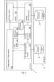
- the augmented reality image server 6 has a 2D database 8 containing 2-dimensional images with points of interest having 2-dimensional (2D) data sets, and a 3D database 9 containing 3-dimensional images with points of interest having 3-dimensional (3D) data sets.
- the augmented reality i.e. 3D device 7 has an image sensor 10, an adjustable lens 11, and 3D-sensors 12 which are able to determine a depth i.e. distance between the 3D device and a visible object.
- the 3D device further has an absolute positioning sensor 13, a GPS sensor in this example, and a display 14.
- Further shown in Figure 2 are a 2D image recognition module 15, a 3D data capture module 16, and 2D to 3D converter module 17.
- these are shown as separate hardware modules being part of the 3D device 7.
- these modules may be implemented as software modules executed by a general processing unit.
- these modules may be part of the augmented reality image server 6 or located on a separate server as part of an augmented reality system.
- the absolute position sensor is a GPS sensor, but other navigational sensors capable to determine the position of the device in relation to a reference point are also suited, such as e.g. the EU Galileo positioning system or China's BeiDou Navigation Satellite System.
- Other position sensors that allow to obtain an absolute position within a geographical space are also suited, such as position sensor and system that allows to define a fixed known reference point and determine the device position relative to that defined reference position.
- the above steps may be regarded as a learning phase wherein the 3D data base on the AR-server is populated with 3D data sets of the points of interest available for later retrieval.
- 2D image recognition of one image is only required once, as the 3D data set of each point of interest will be stored with global position coordinates.
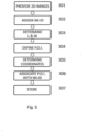
- each image is assigned 302 an image identifier ID-im as a unique means for referring to the image.
- Further properties as length L and width W of the image are determined 303, as is a reference point.
- the reference point may be one of corners of the image, it may be the centre of the image, or it may be any other reference point suitable to be taken as an origin for a coordinate system, such as the origin of a Cartesian system. In the latter case, with the origin on one corner, maximum values for X and Y will be equal to L and W.
- a 2D image database is provided containing 2-dimensional (2D) images associated with points of interest having a 2-dimensional (2D) data set.
- a 3D representation is obtained of the captured 3D image via 3D-sensors and the image sensor of the augmented reality device.
- This 3D representation includes a 2D frame, which in this example is a 2D-image captured by the image sensor, consisting of points defined by two dimensional frame coordinates, for example values for X and Y in a Cartesian coordinate system. Each point in the 2D frame is associated with a depth, similar to the Cartesian coordinate Z, which is obtained by the 3D-sensors.
- the 2D frame could also be constructed as a vector field with a vector Z defined for each point (X, Y).
- the 2D frame does not necessarily need to be continuous, for example it may also be of a discrete form.
- the matching of images of the 2D image database with the 3D-image includes comparing each 2D image of the 2D image database with the 2D frame of the 3D representation by scaling and translating the 2D image over the 2D frame.
- An example of the required processing movements is shown in a simplified manner in Fig. 6 .
- This capturing of 3D-data for the matched 2D-image includes determining frame coordinates of the reference point of the 2D image in the 2D frame of the 3D representation.
- the capturing further includes determining scale information, and obtaining a distance D between the augmented reality device and the 2D-image; which both may be obtained from the lens of the 3D device.
- One common way of performing scaling is a homothetic projection, which allows resizing of a shape while maintaining its' ratio aspects and with minimal deformation.
- the frame coordinates, scale information, distance D and image identifier of the matched image may be stored in a matched image object as an intermediate result.
- the 2D-data set of the point-of-interest can be converted to a 3D-data set.
- This converting of the 2D-data set to the 3D-data set includes applying the scaling information to the first coordinates of the point of interest.
- the converting further includes applying the frame coordinates of the reference point to the coordinates of the point of interest to obtain frame coordinates of the point of interest.
- the depth associated with frame coordinates of the point of interest and the scaling information is processed to calculate the depth coordinate. In this manner, a set of 3-dimensional coordinates of the point of interest is obtained, defined in the coordinate system of the augmented reality device R'.
- These frame coordinates may be converted to global position coordinates, such as e.g; known as GPS. Thereto, a global position of the augmented reality device is obtained. From this a global position of the point of interest is obtained by applying the global position of the augmented reality device to the frame and depth coordinates of the point of interest. These 3D data may then be stored as the global position of the point of interest in the 3D data set.
- global position coordinates such as e.g; known as GPS.
- Figure 6 shows the relation of the coordinate space R of the 2D image 18 and a possible coordinate space R' of the augmented reality device.
- the device coordinate space could also be defined by spherical coordinates.
- the 2D images are processed one by one by the 2D recognition tool to be matched 401 with captured 3D image.
- a match-image object is created containing the image identifier ID-im, updated coordinates X' and Y' defining the coordinates of the origin in the captures 3D image, and scale-information defining the scale of the 2D image in the captured 3D image.
- the captured 3D image may show multiple points-of-interest
- the 3D image is compared with further 2D images of the 2D image database; if further matches are obtained these are also stored in the match-image object. Therefore, in case of a match it is checked whether this is a new match 402 or not.
- the location of the 3D device may be known the number of 2D images relevant to be compared may be limited based on the location.
- the 2D data X-poi, Y-poi are converted 403 by the 2Dto3D module to one 3D data set which is stored in the 3D database 9.
- the conversion is performed by processing the match-image objects for each 2D image associated with the 3D image.
- the 2D image matching may by itself also contain multiple points-of-interest, in which case the converting of the 2D data set is applied to all points-of-interest defined for that image. All the converted 3D data sets are stored in the 3D database 9.
- the 3D image will be shown on the display of the 3D device together with all identified points-of-interest.
Landscapes
- Engineering & Computer Science (AREA)
- Theoretical Computer Science (AREA)
- General Physics & Mathematics (AREA)
- Physics & Mathematics (AREA)
- General Engineering & Computer Science (AREA)
- Computer Graphics (AREA)
- Computer Hardware Design (AREA)
- Multimedia (AREA)
- Software Systems (AREA)
- Library & Information Science (AREA)
- Signal Processing (AREA)
- Architecture (AREA)
- Data Mining & Analysis (AREA)
- Databases & Information Systems (AREA)
- Processing Or Creating Images (AREA)
- Testing, Inspecting, Measuring Of Stereoscopic Televisions And Televisions (AREA)
Claims (6)
- Verfahren zum Abbilden eines 2D-Point-of-Interest in einer dreidimensionalen Ansicht, das aufweist:Erfassen (102) eines dreidimensionalen (3D) Bilds mit einer Augmented Reality-Vorrichtung (7), indem eine 3D-Darstellung des 3D-Bilds über 3D-Sensoren (12) und einen Bildsensor (10) der Augmented Reality-Vorrichtung erhalten wird, und wobei die 3D-Darstellung ein 2D-Einzelbild aufweist, wobei das 2D-Einzelbild ein 2D-Bild ist, das vom Bildsensor (10) erfasst wird und aus Punkten besteht, die durch zweidimensionale Einzelbildkoordinaten definiert sind, und wobei ein jeder Punkt mit einer Tiefe verknüpft ist, die von den 3D-Sensoren (12) erfasst wird;Abgleichen (103) vom Bildern einer 2D-Bilddatenbank (8) mit dem erfassten 3D-Bild, indem ein jedes 2D-Bild der 2D-Bilddatenbank mit dem 2D-Einzelbild der 3D-Darstellung durch Skalieren und Verschieben des 2D-Bilds über dem 2D-Einzelbild verglichen wird;wobei die 2D-Bilddatenbank (8) zweidimensionale (2D) Bilder aufweist, die mit Point-of-Interests verknüpft sind, die ein zweidimensionales (2D) Datenset haben;wobei erste Koordinaten eines Point-of-Interest im Bezug zum Referenzpunkt des Bilds bestimmt werden, wobei der Referenzpunkt ein Punkt ist, der geeignet ist, als ein Ursprung für ein Koordinatensystem verwendet zu werden; undwenn das 2D-Bild mit dem 3D-Bild übereinstimmt:
Erfassen von 3D-Daten (104) für das abgeglichene 2D-Bild, indem:Einzelbildkoordinaten des Referenzpunkts des 2D-Bilds im 2D-Einzelbild bestimmt werden;Skalierungsinformationen aus der 2D-Bildgröße und der 2D-Einzelbildgröße bestimmt werden;Umwandeln (105) des 2D-Datensets des Point-of-Interest in ein 3D-Datenset, indem:Skalierungsinformationen auf die Koordinaten des Point-of-Interest angewendet werden;Einzelbildkoordinaten des Referenzpunkts auf die ersten Koordinaten des Point-of-Interest angewendet werden, um Einzelbildkoordinaten des Point-of-Interest zu erhalten; undeine Tiefenkoordinate für den Point-of-Interest aus der Tiefe bestimmt wird, die mit den Einzelbildkoordinaten des Point-of-Interest und den Skalierungsinformationen verknüpft ist,Erfassen von globalen Positionskoordinaten der Augmented Reality-Vorrichtung unter Verwendung eines absoluten Positionierungssensors (13); undSpeichern des Point-of-Interest mit den globalen Positionskoordinaten der Augmented Reality-Vorrichtung. - Verfahren nach Anspruch 1, wobei die 2D-Bilddatenbank erstellt wird durch:bereitstellen (301) von 2D-Bildem;für ein jedes Bild:Zuweisen (302) einer Bildkennung;Bestimmen (303 einer Länge und Breite des Bilds;Definieren (304) von wenigstens eines Point-of-Interest, die eine jeweilige Point-of-Interest-Kennung hat,Bestimmen (305) der ersten Koordinaten von dem wenigstens einen Point-of-Interest in Bezug zum Referenzpunkt des Bilds;Verknüpfen (306) eines jeden Point-of-Interest mit der Bildkennung;Speichern (307) der Bildkennung, der Länge und Breite, des Referenzpunkts, der Point-of-Interest-Kennung, der Koordinaten von des wenigsten einen Point-of-Interest, der Verknüpfung mit einem jeden definierten Point-of-Interest.
- Verfahren nach Anspruch 1 oder 2, wobei das Umwandeln des 2D-Datensets des Point-of-Interest in ein 3D-Datenset weiterhin aufweist:Bestimmen einer absoluten Position des Point-of-Interest durch Anwenden der absoluten Position der Augmented Reality-Vorrichtung auf das Einzelbild und die Tiefenkoordinaten des Point-of-Interest; undSpeichern der absoluten Position des Point-of-Interest im 3D-Datenset.
- Verfahren zum Anzeigen eines 2D-Point-of-Interest in einer dreidimensionalen Ansicht, das aufweist:Vorsehen einer 3D-Bilddatenbank, die Point-of-Interests aufweist, die ein dreidimensionales (3D) Datenset haben, das durch das Verfahren gemäß einem der vorhergehenden Ansprüche erhalten wurde; undAnzeigen des Point-of-Interest in der 3D-Ansicht als Augmented Reality.
- Augmented Reality-Vorrichtung zum Erfassen eines 3D-Bilds, das aufweist:eine einstellbare Linse (11);einen Bildsensor (10);3D-Sensoren (12);einen Absoluten Positionierungssensor (13); undeinen Anzeige (14); undeine Verarbeitungseinheit (15, 16, 17), die ausgelegt ist zum Erfassen (102) eines dreidimensionalen (3D) Bilds, indem eine 3D-Darstellung des 3D-Bilds über 3D-Sensoren (12) und den Bildsensor (10) der Augmented Reality-Vorrichtung erhalten wird, und wobei die 3D-Darstellung ein 2D-Einzelbild aufweist, wobei das 2D-Einzelbild ein 2D-Bild ist, das vom Bildsensor (10) erfasst wird und aus Punkten besteht, die durch zweidimensionale Einzelbildkoordinaten definiert werden, und wobei ein jeder Punkt mit einer Tiefe verknüpft ist, die von den 3D-Sensoren (12) erfasst wird;Abgleichen (103) vom Bildern einer 2D-Bilddatenbank (8) mit einem vom Bildsensor (10) und den 3D-Sensoren (12) erfassten 3D-Bild, indem ein jedes 2D-Bild der 2D-Bilddatenbank mit dem 2D-Einzelbild der 3D-Darstellung durch Skalieren und Verschieben des 2D-Bilds über dem 2D-Einzelbild verglichen wird;wobei die 2D-Bilddatenbank (8) zweidimensionale (2D) Bilder aufweist, die mit Point-of-Interests verknüpft sind, die ein zweidimensionales (2D) Datenset haben;wobei die ersten Koordinaten eines Point-of-Interest im Bezug zu einem Referenzpunkt des Bilds bestimmt werden, wobei der Referenzpunkt ein Punkt ist, der geeignet ist, als ein Ursprung für ein Koordinatensystem verwendet zu werden; undErfassen von 3D-Daten des 3D-Bilds aus den 3D-Sensoren (12) und der Linse (11), wenn das 2D-Bild mit dem 3D-Bild übereinstimmt, indem:Einzelbildkoordinaten des Referenzpunkts des 2D-Bilds im 2D-Einzelbild bestimmt werden;Skalierungsinformationen aus der 2D-Bildgröße und der 2D-Einzelbildgröße bestimmt werden;das 2D-Datenset des Point-of-Interest in ein 3D-Datenset umgewandelt wird, indem:die Skalierungsinformationen auf die Koordinaten des Point-of-Interest angewendet werden;die Einzelbildkoordinaten des Referenzpunkts auf die Koordinaten des Point-of-Interest angewendet werden, um Einzelbildkoordinaten des Point-of-Interest zu erhalten; undeine Tiefenkoordinate für den Point-of-Interest aus der Tiefe bestimmt wird, die mit den Einzelbildkoordinaten des Point-of-Interest und den Skalierungsinformationen verknüpft ist, undSpeichern der Markierung mit globalen Positionskoordinaten der Augmented Reality-Vorrichtung, die von dem Absoluten Positionierungssensor erfasst wurden.
- System zum Bereitstellen von Augmented Reality, das aufweist:eine Augmented Reality-Vorrichtung (7) nach Anspruch 5;einen Augmented Reality-Bildserver (6), der aufweist:die 2D-Bilddatenbank (8), die Bilder mit Point-of-Interests aufweist, die zweidimensionale (2D) Datensets haben;eine 3D-Bilddatenbank (9), die Bilder mit Point-of-Interests aufweist, die dreidimensionale (3D) Datensets haben.
Applications Claiming Priority (1)
| Application Number | Priority Date | Filing Date | Title |
|---|---|---|---|
| EP16192817 | 2016-10-07 |
Publications (2)
| Publication Number | Publication Date |
|---|---|
| EP3306572A1 EP3306572A1 (de) | 2018-04-11 |
| EP3306572B1 true EP3306572B1 (de) | 2025-03-05 |
Family
ID=57226747
Family Applications (1)
| Application Number | Title | Priority Date | Filing Date |
|---|---|---|---|
| EP17191366.8A Active EP3306572B1 (de) | 2016-10-07 | 2017-09-15 | Verfahren zur 3d-abbildung von 2d-markierungen |
Country Status (6)
| Country | Link |
|---|---|
| US (1) | US11074448B2 (de) |
| EP (1) | EP3306572B1 (de) |
| JP (1) | JP7086559B2 (de) |
| KR (1) | KR102373910B1 (de) |
| CN (1) | CN107918954B (de) |
| ES (1) | ES3019009T3 (de) |
Families Citing this family (7)
| Publication number | Priority date | Publication date | Assignee | Title |
|---|---|---|---|---|
| IT201900005806A1 (it) * | 2019-04-15 | 2020-10-15 | Pikkart Srl | Metodo per realizzare realta' aumentata |
| US11770517B2 (en) * | 2019-10-28 | 2023-09-26 | Sony Group Corporation | Information processing apparatus and information processing method |
| US11043038B1 (en) * | 2020-03-16 | 2021-06-22 | Hong Kong Applied Science and Technology Research Institute Company Limited | Apparatus and method of three-dimensional interaction for augmented reality remote assistance |
| CN113538572A (zh) * | 2020-04-17 | 2021-10-22 | 杭州三坛医疗科技有限公司 | 一种目标对象的坐标确定方法、装置和设备 |
| CN112183657B (zh) * | 2020-10-14 | 2022-03-01 | 北京字跳网络技术有限公司 | 获取标注信息的方法、装置、电子设备和计算机可读介质 |
| CN113436253B (zh) * | 2021-06-28 | 2023-05-16 | 华科融资租赁有限公司 | 地图的定位显示方法、装置、计算机设备和存储介质 |
| CN114119887B (zh) * | 2021-10-29 | 2025-03-07 | 杭州涂鸦信息技术有限公司 | 扫地机的位置显示方法、装置、计算机设备和存储介质 |
Family Cites Families (14)
| Publication number | Priority date | Publication date | Assignee | Title |
|---|---|---|---|---|
| JP4284644B2 (ja) * | 2003-05-23 | 2009-06-24 | 財団法人生産技術研究奨励会 | 3次元モデル構築システム及び3次元モデル構築プログラム |
| JP2007226580A (ja) * | 2006-02-24 | 2007-09-06 | Advanced Telecommunication Research Institute International | 画像出力装置、及び画像出力方法 |
| CN102762142B (zh) * | 2010-02-12 | 2016-01-27 | 皇家飞利浦电子股份有限公司 | 3d表面的激光增强重建 |
| KR101685980B1 (ko) * | 2010-07-30 | 2016-12-13 | 엘지전자 주식회사 | 이동 단말기 및 그 제어방법 |
| JP5839929B2 (ja) * | 2010-11-19 | 2016-01-06 | キヤノン株式会社 | 情報処理装置、情報処理システム、情報処理方法及びプログラム |
| JP5676387B2 (ja) * | 2011-07-27 | 2015-02-25 | 株式会社日立製作所 | 外観検査方法及びその装置 |
| US20130328926A1 (en) * | 2012-06-08 | 2013-12-12 | Samsung Electronics Co., Ltd | Augmented reality arrangement of nearby location information |
| US9576183B2 (en) * | 2012-11-02 | 2017-02-21 | Qualcomm Incorporated | Fast initialization for monocular visual SLAM |
| US9646384B2 (en) * | 2013-09-11 | 2017-05-09 | Google Technology Holdings LLC | 3D feature descriptors with camera pose information |
| CN110379019A (zh) * | 2013-09-24 | 2019-10-25 | 苹果公司 | 在真实环境的视图中表示兴趣点的方法以及移动设备 |
| US9286718B2 (en) * | 2013-09-27 | 2016-03-15 | Ortery Technologies, Inc. | Method using 3D geometry data for virtual reality image presentation and control in 3D space |
| JP2015228050A (ja) * | 2014-05-30 | 2015-12-17 | ソニー株式会社 | 情報処理装置および情報処理方法 |
| TWI605795B (zh) * | 2014-08-19 | 2017-11-21 | 鈦隼生物科技股份有限公司 | 判定手術部位中探針位置之方法與系統 |
| US9996936B2 (en) * | 2016-05-20 | 2018-06-12 | Qualcomm Incorporated | Predictor-corrector based pose detection |
-
2017
- 2017-09-15 ES ES17191366T patent/ES3019009T3/es active Active
- 2017-09-15 EP EP17191366.8A patent/EP3306572B1/de active Active
- 2017-09-27 KR KR1020170125510A patent/KR102373910B1/ko active Active
- 2017-09-28 CN CN201710897022.6A patent/CN107918954B/zh active Active
- 2017-10-05 US US15/725,793 patent/US11074448B2/en active Active
- 2017-10-06 JP JP2017196096A patent/JP7086559B2/ja active Active
Also Published As
| Publication number | Publication date |
|---|---|
| CN107918954A (zh) | 2018-04-17 |
| CN107918954B (zh) | 2023-08-04 |
| KR102373910B1 (ko) | 2022-03-11 |
| EP3306572A1 (de) | 2018-04-11 |
| JP7086559B2 (ja) | 2022-06-20 |
| KR20180038981A (ko) | 2018-04-17 |
| US11074448B2 (en) | 2021-07-27 |
| JP2018077836A (ja) | 2018-05-17 |
| ES3019009T3 (en) | 2025-05-20 |
| US20180101729A1 (en) | 2018-04-12 |
Similar Documents
| Publication | Publication Date | Title |
|---|---|---|
| US11074448B2 (en) | Method for 3D mapping of 2D point of interest | |
| JP2024525327A (ja) | Slamに基づくモバイルロボットによる鉱山のシーン再構成方法及びシステム | |
| JP6023831B2 (ja) | 仮想参照画像を用いた位置及び向きの検出のための方法 | |
| JP2017118396A (ja) | デプスカメラの内部パラメータを算出するプログラム、装置及び方法 | |
| KR102490521B1 (ko) | 라이다 좌표계와 카메라 좌표계의 벡터 정합을 통한 자동 캘리브레이션 방법 | |
| CN111383205B (zh) | 一种基于特征点和三维模型的图像融合定位方法 | |
| US10127667B2 (en) | Image-based object location system and process | |
| JP2017182695A (ja) | 情報処理プログラム、情報処理方法および情報処理装置 | |
| CN114119864A (zh) | 一种基于三维重建与点云匹配的定位方法和装置 | |
| CN110686704A (zh) | 激光雷达与组合惯导的位姿标定方法、系统及介质 | |
| Xie et al. | As-built BIM reconstruction of piping systems using smartphone videogrammetry and terrestrial laser scanning | |
| CN106131794A (zh) | 室内定位的方法及装置 | |
| JP2022105442A (ja) | 情報処理装置、情報処理方法およびプログラム | |
| US20020094134A1 (en) | Method and system for placing three-dimensional models | |
| JPWO2021111613A1 (ja) | 3次元地図作成装置、3次元地図作成方法、及び3次元地図作成プログラム | |
| KR20240027395A (ko) | 모바일 환경에서 단일 이미지 객체 인식 기반의 시각적 측위 방법 및 장치 | |
| CN116907536A (zh) | 信息处理装置及其控制方法、信息处理系统和存储介质 | |
| US12277663B2 (en) | Measurement processing device, method, and program | |
| Tian et al. | A study on three-dimensional vision system for machining setup verification | |
| KR102458559B1 (ko) | 휴대용 단말기를 이용한 건설 분야 시공 관리 시스템 및 방법 | |
| JPH11338532A (ja) | 教示装置 | |
| CN115063489B (zh) | 一种外参标定方法、装置、设备和存储介质 | |
| Ruzgiene | Comparison between digital photogrammetric systems | |
| BILIAVSKYI et al. | Digital mapping of territories using SLAM technology: analysis of the accuracy of the results obtained | |
| Rzonca et al. | Lidarometry as a variant of integration of photogrammetric and laser scanning data |
Legal Events
| Date | Code | Title | Description |
|---|---|---|---|
| PUAI | Public reference made under article 153(3) epc to a published international application that has entered the european phase |
Free format text: ORIGINAL CODE: 0009012 |
|
| STAA | Information on the status of an ep patent application or granted ep patent |
Free format text: STATUS: THE APPLICATION HAS BEEN PUBLISHED |
|
| AK | Designated contracting states |
Kind code of ref document: A1 Designated state(s): AL AT BE BG CH CY CZ DE DK EE ES FI FR GB GR HR HU IE IS IT LI LT LU LV MC MK MT NL NO PL PT RO RS SE SI SK SM TR |
|
| AX | Request for extension of the european patent |
Extension state: BA ME |
|
| STAA | Information on the status of an ep patent application or granted ep patent |
Free format text: STATUS: REQUEST FOR EXAMINATION WAS MADE |
|
| 17P | Request for examination filed |
Effective date: 20181005 |
|
| RBV | Designated contracting states (corrected) |
Designated state(s): AL AT BE BG CH CY CZ DE DK EE ES FI FR GB GR HR HU IE IS IT LI LT LU LV MC MK MT NL NO PL PT RO RS SE SI SK SM TR |
|
| STAA | Information on the status of an ep patent application or granted ep patent |
Free format text: STATUS: EXAMINATION IS IN PROGRESS |
|
| 17Q | First examination report despatched |
Effective date: 20200824 |
|
| RIC1 | Information provided on ipc code assigned before grant |
Ipc: G06T 19/20 20110101ALI20240802BHEP Ipc: G06T 19/00 20110101AFI20240802BHEP Ipc: G06F 16/583 20190101ALI20240802BHEP |
|
| GRAP | Despatch of communication of intention to grant a patent |
Free format text: ORIGINAL CODE: EPIDOSNIGR1 |
|
| STAA | Information on the status of an ep patent application or granted ep patent |
Free format text: STATUS: GRANT OF PATENT IS INTENDED |
|
| INTG | Intention to grant announced |
Effective date: 20241002 |
|
| GRAS | Grant fee paid |
Free format text: ORIGINAL CODE: EPIDOSNIGR3 |
|
| GRAA | (expected) grant |
Free format text: ORIGINAL CODE: 0009210 |
|
| STAA | Information on the status of an ep patent application or granted ep patent |
Free format text: STATUS: THE PATENT HAS BEEN GRANTED |
|
| AK | Designated contracting states |
Kind code of ref document: B1 Designated state(s): AL AT BE BG CH CY CZ DE DK EE ES FI FR GB GR HR HU IE IS IT LI LT LU LV MC MK MT NL NO PL PT RO RS SE SI SK SM TR |
|
| REG | Reference to a national code |
Ref country code: GB Ref legal event code: FG4D |
|
| REG | Reference to a national code |
Ref country code: CH Ref legal event code: EP |
|
| REG | Reference to a national code |
Ref country code: IE Ref legal event code: FG4D |
|
| REG | Reference to a national code |
Ref country code: DE Ref legal event code: R096 Ref document number: 602017088134 Country of ref document: DE |
|
| REG | Reference to a national code |
Ref country code: ES Ref legal event code: FG2A Ref document number: 3019009 Country of ref document: ES Kind code of ref document: T3 Effective date: 20250520 |
|
| PG25 | Lapsed in a contracting state [announced via postgrant information from national office to epo] |
Ref country code: RS Free format text: LAPSE BECAUSE OF FAILURE TO SUBMIT A TRANSLATION OF THE DESCRIPTION OR TO PAY THE FEE WITHIN THE PRESCRIBED TIME-LIMIT Effective date: 20250605 |
|
| PG25 | Lapsed in a contracting state [announced via postgrant information from national office to epo] |
Ref country code: FI Free format text: LAPSE BECAUSE OF FAILURE TO SUBMIT A TRANSLATION OF THE DESCRIPTION OR TO PAY THE FEE WITHIN THE PRESCRIBED TIME-LIMIT Effective date: 20250305 |
|
| REG | Reference to a national code |
Ref country code: NL Ref legal event code: MP Effective date: 20250305 |
|
| REG | Reference to a national code |
Ref country code: LT Ref legal event code: MG9D |
|
| PG25 | Lapsed in a contracting state [announced via postgrant information from national office to epo] |
Ref country code: NO Free format text: LAPSE BECAUSE OF FAILURE TO SUBMIT A TRANSLATION OF THE DESCRIPTION OR TO PAY THE FEE WITHIN THE PRESCRIBED TIME-LIMIT Effective date: 20250605 |
|
| PG25 | Lapsed in a contracting state [announced via postgrant information from national office to epo] |
Ref country code: HR Free format text: LAPSE BECAUSE OF FAILURE TO SUBMIT A TRANSLATION OF THE DESCRIPTION OR TO PAY THE FEE WITHIN THE PRESCRIBED TIME-LIMIT Effective date: 20250305 |
|
| PG25 | Lapsed in a contracting state [announced via postgrant information from national office to epo] |
Ref country code: LV Free format text: LAPSE BECAUSE OF FAILURE TO SUBMIT A TRANSLATION OF THE DESCRIPTION OR TO PAY THE FEE WITHIN THE PRESCRIBED TIME-LIMIT Effective date: 20250305 |
|
| PG25 | Lapsed in a contracting state [announced via postgrant information from national office to epo] |
Ref country code: GR Free format text: LAPSE BECAUSE OF FAILURE TO SUBMIT A TRANSLATION OF THE DESCRIPTION OR TO PAY THE FEE WITHIN THE PRESCRIBED TIME-LIMIT Effective date: 20250606 Ref country code: BG Free format text: LAPSE BECAUSE OF FAILURE TO SUBMIT A TRANSLATION OF THE DESCRIPTION OR TO PAY THE FEE WITHIN THE PRESCRIBED TIME-LIMIT Effective date: 20250305 |
|
| REG | Reference to a national code |
Ref country code: AT Ref legal event code: MK05 Ref document number: 1773654 Country of ref document: AT Kind code of ref document: T Effective date: 20250305 |
|
| PG25 | Lapsed in a contracting state [announced via postgrant information from national office to epo] |
Ref country code: NL Free format text: LAPSE BECAUSE OF FAILURE TO SUBMIT A TRANSLATION OF THE DESCRIPTION OR TO PAY THE FEE WITHIN THE PRESCRIBED TIME-LIMIT Effective date: 20250305 |
|
| PG25 | Lapsed in a contracting state [announced via postgrant information from national office to epo] |
Ref country code: SE Free format text: LAPSE BECAUSE OF FAILURE TO SUBMIT A TRANSLATION OF THE DESCRIPTION OR TO PAY THE FEE WITHIN THE PRESCRIBED TIME-LIMIT Effective date: 20250305 |
|
| PG25 | Lapsed in a contracting state [announced via postgrant information from national office to epo] |
Ref country code: SM Free format text: LAPSE BECAUSE OF FAILURE TO SUBMIT A TRANSLATION OF THE DESCRIPTION OR TO PAY THE FEE WITHIN THE PRESCRIBED TIME-LIMIT Effective date: 20250305 |
|
| PG25 | Lapsed in a contracting state [announced via postgrant information from national office to epo] |
Ref country code: PT Free format text: LAPSE BECAUSE OF FAILURE TO SUBMIT A TRANSLATION OF THE DESCRIPTION OR TO PAY THE FEE WITHIN THE PRESCRIBED TIME-LIMIT Effective date: 20250707 |
|
| PGFP | Annual fee paid to national office [announced via postgrant information from national office to epo] |
Ref country code: DE Payment date: 20250926 Year of fee payment: 9 |
|
| PG25 | Lapsed in a contracting state [announced via postgrant information from national office to epo] |
Ref country code: PL Free format text: LAPSE BECAUSE OF FAILURE TO SUBMIT A TRANSLATION OF THE DESCRIPTION OR TO PAY THE FEE WITHIN THE PRESCRIBED TIME-LIMIT Effective date: 20250305 |
|
| PGFP | Annual fee paid to national office [announced via postgrant information from national office to epo] |
Ref country code: IT Payment date: 20250922 Year of fee payment: 9 |
|
| PG25 | Lapsed in a contracting state [announced via postgrant information from national office to epo] |
Ref country code: AT Free format text: LAPSE BECAUSE OF FAILURE TO SUBMIT A TRANSLATION OF THE DESCRIPTION OR TO PAY THE FEE WITHIN THE PRESCRIBED TIME-LIMIT Effective date: 20250305 |
|
| PGFP | Annual fee paid to national office [announced via postgrant information from national office to epo] |
Ref country code: FR Payment date: 20250925 Year of fee payment: 9 |
|
| PG25 | Lapsed in a contracting state [announced via postgrant information from national office to epo] |
Ref country code: EE Free format text: LAPSE BECAUSE OF FAILURE TO SUBMIT A TRANSLATION OF THE DESCRIPTION OR TO PAY THE FEE WITHIN THE PRESCRIBED TIME-LIMIT Effective date: 20250305 Ref country code: CZ Free format text: LAPSE BECAUSE OF FAILURE TO SUBMIT A TRANSLATION OF THE DESCRIPTION OR TO PAY THE FEE WITHIN THE PRESCRIBED TIME-LIMIT Effective date: 20250305 |
|
| PG25 | Lapsed in a contracting state [announced via postgrant information from national office to epo] |
Ref country code: RO Free format text: LAPSE BECAUSE OF FAILURE TO SUBMIT A TRANSLATION OF THE DESCRIPTION OR TO PAY THE FEE WITHIN THE PRESCRIBED TIME-LIMIT Effective date: 20250305 |
|
| PG25 | Lapsed in a contracting state [announced via postgrant information from national office to epo] |
Ref country code: SK Free format text: LAPSE BECAUSE OF FAILURE TO SUBMIT A TRANSLATION OF THE DESCRIPTION OR TO PAY THE FEE WITHIN THE PRESCRIBED TIME-LIMIT Effective date: 20250305 |
|
| PG25 | Lapsed in a contracting state [announced via postgrant information from national office to epo] |
Ref country code: IS Free format text: LAPSE BECAUSE OF FAILURE TO SUBMIT A TRANSLATION OF THE DESCRIPTION OR TO PAY THE FEE WITHIN THE PRESCRIBED TIME-LIMIT Effective date: 20250705 |
|
| REG | Reference to a national code |
Ref country code: DE Ref legal event code: R097 Ref document number: 602017088134 Country of ref document: DE |
|
| PLBE | No opposition filed within time limit |
Free format text: ORIGINAL CODE: 0009261 |
|
| STAA | Information on the status of an ep patent application or granted ep patent |
Free format text: STATUS: NO OPPOSITION FILED WITHIN TIME LIMIT |
|
| PG25 | Lapsed in a contracting state [announced via postgrant information from national office to epo] |
Ref country code: DK Free format text: LAPSE BECAUSE OF FAILURE TO SUBMIT A TRANSLATION OF THE DESCRIPTION OR TO PAY THE FEE WITHIN THE PRESCRIBED TIME-LIMIT Effective date: 20250305 |
|
| REG | Reference to a national code |
Ref country code: CH Ref legal event code: L10 Free format text: ST27 STATUS EVENT CODE: U-0-0-L10-L00 (AS PROVIDED BY THE NATIONAL OFFICE) Effective date: 20260114 |
|
| PGFP | Annual fee paid to national office [announced via postgrant information from national office to epo] |
Ref country code: ES Payment date: 20251015 Year of fee payment: 9 |
|
| 26N | No opposition filed |
Effective date: 20251208 |
|
| REG | Reference to a national code |
Ref country code: CH Ref legal event code: H13 Free format text: ST27 STATUS EVENT CODE: U-0-0-H10-H13 (AS PROVIDED BY THE NATIONAL OFFICE) Effective date: 20260504 |