EP3321165A1 - Système de guidage d'évitement de collision de navire utilisant un affichage graphique chronologique - Google Patents
Système de guidage d'évitement de collision de navire utilisant un affichage graphique chronologique Download PDFInfo
- Publication number
- EP3321165A1 EP3321165A1 EP16821627.3A EP16821627A EP3321165A1 EP 3321165 A1 EP3321165 A1 EP 3321165A1 EP 16821627 A EP16821627 A EP 16821627A EP 3321165 A1 EP3321165 A1 EP 3321165A1
- Authority
- EP
- European Patent Office
- Prior art keywords
- ship
- avoidance
- collision
- information
- ships
- Prior art date
- Legal status (The legal status is an assumption and is not a legal conclusion. Google has not performed a legal analysis and makes no representation as to the accuracy of the status listed.)
- Withdrawn
Links
- 238000000034 method Methods 0.000 claims abstract description 19
- 238000004088 simulation Methods 0.000 claims abstract description 19
- 238000012545 processing Methods 0.000 claims description 18
- 238000004891 communication Methods 0.000 claims description 9
- 230000002265 prevention Effects 0.000 abstract description 7
- 230000006870 function Effects 0.000 description 4
- 238000013459 approach Methods 0.000 description 3
- QZXCCPZJCKEPSA-UHFFFAOYSA-N chlorfenac Chemical compound OC(=O)CC1=C(Cl)C=CC(Cl)=C1Cl QZXCCPZJCKEPSA-UHFFFAOYSA-N 0.000 description 1
- 239000003086 colorant Substances 0.000 description 1
- 238000012790 confirmation Methods 0.000 description 1
- 238000013461 design Methods 0.000 description 1
- 230000000694 effects Effects 0.000 description 1
- 230000009545 invasion Effects 0.000 description 1
- 238000012986 modification Methods 0.000 description 1
- 230000004048 modification Effects 0.000 description 1
- 230000008520 organization Effects 0.000 description 1
- 238000006467 substitution reaction Methods 0.000 description 1
Images

Classifications
-
- G—PHYSICS
- G08—SIGNALLING
- G08G—TRAFFIC CONTROL SYSTEMS
- G08G3/00—Traffic control systems for marine craft
- G08G3/02—Anti-collision systems
-
- B—PERFORMING OPERATIONS; TRANSPORTING
- B63—SHIPS OR OTHER WATERBORNE VESSELS; RELATED EQUIPMENT
- B63B—SHIPS OR OTHER WATERBORNE VESSELS; EQUIPMENT FOR SHIPPING
- B63B45/00—Arrangements or adaptations of signalling or lighting devices
-
- B—PERFORMING OPERATIONS; TRANSPORTING
- B63—SHIPS OR OTHER WATERBORNE VESSELS; RELATED EQUIPMENT
- B63B—SHIPS OR OTHER WATERBORNE VESSELS; EQUIPMENT FOR SHIPPING
- B63B49/00—Arrangements of nautical instruments or navigational aids
Definitions
- the present invention relates to a ship collision avoidance guiding system using time series graphic display which is configured to calculate changes in relative distance according to a time with respect to respective ships and obstacles on the basis of the current position and a moving speed of ships or nearby obstacles such as bridges based on information provided from the electronic chart display and information systems (ECDIS) and a radar system to represent the changes in relative distance in a time series graph and further in the case of a ship, display whether the ship is on portside or starboard on the basis of radar information, and when the relative distance with a specific ship is equal to or less than a predetermined threshold value, notify avoidance to the ship having the obligation to keep out of the way through an alarm, thereby identifying the position of the ship nearby at sea and the obstacle, a crossing time, and whether
- ECDIS electronic chart display and information system
- the present invention relates to a ship collision avoidance guiding system using a time series graph display which is configured to easily identify positions of ships at sea and obstacles, a crossing time, and whether the ship is to be avoided and effectively prevent collision, and enable simulation for a crossing event and avoidance by inputting an arbitrary value so that it is possible to quickly and accurately determine whether to avoid when a navigation route for avoidance is planned in a short distance.
- ELC electronic navigational chart
- Such an electronic navigational chart is produced according to a digital waterway data exchange standard S-57 established by International Hydrographic Organization (IHO) and is configured to transmit data produced according to S-57 to different types of computers according to ISO/IEC 8211 regulation.
- IHO International Hydrographic Organization
- ECDIS electronic chart display and information systems
- a database of the electronic navigation chart is optimized for every purpose in order to use the electronic navigation chart for a simplified electronic chart system (ECS), which is mounted on a small or medium size ship, a ship automatic tracking apparatus (ATA), a GPS plotter, or a mobile navigation device.
- ECS electronic chart display and information systems
- ATA ship automatic tracking apparatus
- GPS plotter GPS plotter
- a simplified electronic navigation chart producing method for a ship automatic tracking system using an international electronic navigation chart which performs a step of separately storing data of the electronic navigation chart in a memory for every record; a step of optimizing data set descriptive records (DDR) which describe a data structure and a definition among the data stored in the memory; a step of optimizing meta records indicating confirmation of general information of data, general information on a data structure, and parameter information required to interpret data; a step of optimizing a record reader and directory including information such as a method of reading contents included in each field of the electronic navigation and a size thereof; a step of optimizing a feature object identifier (FOID) of a feature record which is a field assigning an unique identifier in the world for an object indicated by the record; and a step of optimizing a vector record attribute field (ATT)
- an avoidance route searching support system of a ship in a navigable route by using a technique of generating a quadrangular unit route which is configured to include an input unit which receives electronic navigation chart information, navigation information of own ship and other ship, and own ship's scheduled route; a calculating unit which generates a quadrangular unit route in a navigable route according to the electronic navigation chart information, the navigation information, and own ship's scheduled route input to the input unit and calculates an avoidance route in the quadrangular unit route; and a display unit which displays the avoidance route calculated in the calculating unit on the electronic navigation chart to search the avoidance route in the navigable route when a ship enters or departs along the navigable route near the coast, if there is a risk of collision with the coastline, invasion of the route, and collision with other ships has been suggested.
- a navigation aids arrangement system and method on the basis of an electronic navigation chart which is configured to arrange and verify an optimal navigation aids by configuring an electronic navigation chart based graphic user interface (GUI) and multilaterally analyze and arrange various attribute data of aids to navigation such as a character of light, a height of light, and visibility of light has been suggested.
- GUI graphic user interface
- a collision risk recognition and collision avoidance supporting device based on ECDIS configured to include an electronic navigation chart which collects a position and surrounding geographical information of a ship at sea to display the collected information on a display to set a route based on a GPS and a support unit which supports collision avoidance of the ship by recognizing a dangerous object on the electronic navigation chart and displaying an avoidance route to support a decision of an operator by supporting automatic recognition of a dangerous object on a given route through automatic recognition on other ship's information from an automatic recognizing device and a dangerous object list on the electronic navigation chart and an avoidance route in consideration of a passage width has been suggested.
- the electronic chart display and information systems (ECDIS) and the navigation systems using the same of the related art simply enumerate various navigation information such as information on a navigation route or surrounding areas and a distance from other ship on the electronic navigation chart with respect to a value at a corresponding time. Therefore, there is a disadvantage in that the screen configuration is complex and it is difficult to identify a changing tendency according to a time so that it is not easy for a navigation officer to quickly and accurately only desired information through the screen at a glance.
- the electronic chart display and information systems (ECDIS) and the navigation systems using the same of the related art simply display enumerate various navigation information such as information on a navigation route or surrounding areas and a distance from other ship on a screen. Therefore, for example, when the ship approaches a specific ship with a predetermined distance or shorter, a function of generating a warning to a ship which has an avoidance obligation to effectively prevent collision in advance and determining an optimal route through a simulation when the avoidance route is determined has not been suggested.
- an object of the present invention is to provide a ship collision avoidance guiding system using time series graphic display which is configured to represent changes in a relative distance according to time with respect to respective ships at sea within a predetermined range and obstacles such as bridges in a time series graph and display a left and right positional relationship of each ship to easily identify the position of the ship nearby at sea and obstacles, a crossing time, and whether the ship is to be avoided at a glance to help to quickly and accurately judge the situation in order to solve the problems of a conventional electronic chart display and information system (ECDIS) and navigation systems using the same which have a disadvantage in that various pieces of information are simply enumerated on a screen, which causes complex and unintuitive screen display so that it is difficult to quickly identify desired information.
- ECDIS electronic chart display and information system
- Still another object of the present invention is to provide a ship collision avoidance guiding system using time series graphic display which is configured to easily identify positions of ships at sea and obstacles, a crossing time, and whether the ship is to be avoided and effectively prevent collision, and enable simulation for a crossing event and avoidance by inputting an arbitrary value so that it is possible to quickly and accurately determine whether to avoid when a sea way for avoidance is planned in a short distance.
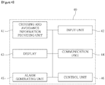
- the crossing and avoidance information providing unit may be configured to perform a processing of displaying the changes in a relative distance according to a time with respect to the ship and the obstacles, the navigation information, and the collision limit line and displaying a left and right positional relationship between the respective ships using radar information to easily identify a ship having an obligation to keep out of the way.
- the ship collision avoidance guiding system may be configured to selectively display only a graph for ships or obstacles corresponding to a criteria based on apredetermined criteria or enlarge or reduce the graph to increase legibility.
- a ship collision avoidance guiding method using time series graphic display for solving the problems of a conventional electronic chart display and information system (ECDIS) and ship collision avoiding methods using the same which have a disadvantage in that various pieces of information are simply enumerated on a screen, which causes complex and unintuitive screen display so that it is difficult to quickly identify desired information, which is configured to provide information on a relative position for respective ships at sea within a predetermined range and obstacles, a crossing time, and whether the ship is to be avoided using the above-described ship collision avoidance guiding system using a time series graphic display so that the position for the ship and the obstacles, the crossing time, and whether the ship is to be avoided are easily identified and when an avoidance route is determined, whether to collide is quickly and accurately determined through a simulation for a crossing event and avoidance to effectively prevent collision between ships and collision between a ship and an obstacle.
- ECDIS electronic chart display and information system
- a ship which is configured to include the above-described ship collision avoidance guiding system using the time series graphic display, in which the relative position for the ship at sea within a predetermined range and the obstacles, the crossing time, and whether the ship is to be avoided are easily identified and when an avoidance route is determined, whether to collide is quickly and accurately determined through a simulation for a crossing event and avoidance.
- a ship collision avoidance guiding system using a time series graphic display which is configured to represent changes in a relative distance according to a time with respect to respective ships at sea within a predetermined range and obstacles in a time series graph and display a left and right positional relationship of each ship to easily identify the position of the ship nearby at sea and obstacles, a crossing time, and whether the ship is to be avoided at a glance to help to quickly and accurately judge the situation is provided, so that it is possible to solve the problems of a conventional electronic chart display and information system (ECDIS) and navigation systems using the same which have a disadvantage in that various pieces of information are simply enumerated on a screen, which causes complex and unintuitive screen display so that it is difficult to quickly identify desired information.
- ECDIS electronic chart display and information system
- a ship collision avoidance guiding system using time series graphic display which is configured to easily identify positions of ships at sea and obstacles, a crossing time, and whether the ship is to be avoided and effectively prevent collision, and enable simulation for a crossing event and avoidance by inputting an arbitrary value is provided so that it is possible to quickly and accurately determine whether to avoid when a sea way for avoidance is planned in a short distance.
- the present invention relates to a ship collision avoidance guiding system using time series graphic display which is configured to represent changes in a relative distance according to a time with respect to respective ships at sea within a predetermined range and obstacles in a time series graph and display a left and right positional relationship of each ship to easily identify the position of the ship nearby at sea and obstacles, a crossing time, and whether the ship is to be avoided at a glance to help to quickly and accurately judge the situation in order to solve the problems of a conventional electronic chart display and information system (ECDIS) and navigation systems using the same which have a disadvantage in that various pieces of information are simply enumerated on a screen, which causes complex and unintuitive screen display so that it is difficult to quickly identify desired information.
- ECDIS electronic chart display and information system
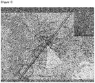
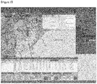
- FIGS. 1 and 2 are views schematically illustrating a display example of an electronic chart screen displayed on the electronic navigation chart display and information system (ECDIS).
- ECDIS electronic navigation chart display and information system
- a position and a speed at a present time of the ship or the obstacle provided by the electronic chart display and information system (ECDIS) and the radar system may be utilized.
- the above-described alarm generating unit 45 may be configured to automatically notify avoidance to a ship having an obligation to keep out of the way or both ships based on the result generated by the crossing and avoidance information providing unit 41.
- a ship collision avoidance guiding system using time series graphic display which is configured to calculate changes in relative distance with a ship according to a time with respect to respective ships and obstacles based on information provided from the electronic chart display and information systems (ECDIS) and a radar system to represent the changes in relative distance in a time series graph and further, in the case of a ship, display whether the ship is on portside or starboard on the basis of radar information, and when the relative distance with a specific ship is equal to or less than a predetermined threshold value, notify avoidance to the ship having the obligation to keep out of the way through an alarm is provided, so that it is possible to identify the position of the ship nearby at sea and the obstacles, a crossing time, and whether the ship is to be avoided and efficiently prevent the collision between ships at sea.
- ECDIS electronic chart display and information systems
Landscapes
- Engineering & Computer Science (AREA)
- Ocean & Marine Engineering (AREA)
- Radar, Positioning & Navigation (AREA)
- Remote Sensing (AREA)
- Physics & Mathematics (AREA)
- General Physics & Mathematics (AREA)
- Traffic Control Systems (AREA)
- Chemical & Material Sciences (AREA)
- Combustion & Propulsion (AREA)
- Mechanical Engineering (AREA)
- Navigation (AREA)
Applications Claiming Priority (2)
| Application Number | Priority Date | Filing Date | Title |
|---|---|---|---|
| KR1020150096634A KR101647743B1 (ko) | 2015-07-07 | 2015-07-07 | 시계열 그래픽 표시를 이용한 선박 충돌회피 안내시스템 |
| PCT/KR2016/007270 WO2017007221A1 (fr) | 2015-07-07 | 2016-07-05 | Système de guidage d'évitement de collision de navire utilisant un affichage graphique chronologique |
Publications (2)
| Publication Number | Publication Date |
|---|---|
| EP3321165A1 true EP3321165A1 (fr) | 2018-05-16 |
| EP3321165A4 EP3321165A4 (fr) | 2019-02-20 |
Family
ID=56714314
Family Applications (1)
| Application Number | Title | Priority Date | Filing Date |
|---|---|---|---|
| EP16821627.3A Withdrawn EP3321165A4 (fr) | 2015-07-07 | 2016-07-05 | Système de guidage d'évitement de collision de navire utilisant un affichage graphique chronologique |
Country Status (7)
| Country | Link |
|---|---|
| US (1) | US10706725B2 (fr) |
| EP (1) | EP3321165A4 (fr) |
| JP (1) | JP6661745B2 (fr) |
| KR (1) | KR101647743B1 (fr) |
| CN (1) | CN107922040A (fr) |
| SG (1) | SG11201800167YA (fr) |
| WO (1) | WO2017007221A1 (fr) |
Cited By (1)
| Publication number | Priority date | Publication date | Assignee | Title |
|---|---|---|---|---|
| CN110544395A (zh) * | 2019-08-28 | 2019-12-06 | 中船重工鹏力(南京)大气海洋信息系统有限公司 | 一种vts系统中船舶追越态势的智能精算预警方法 |
Families Citing this family (31)
| Publication number | Priority date | Publication date | Assignee | Title |
|---|---|---|---|---|
| JP6627615B2 (ja) * | 2016-03-31 | 2020-01-08 | 富士通株式会社 | 評価プログラム、評価方法および評価装置 |
| KR101918980B1 (ko) | 2017-02-20 | 2018-11-15 | (주)뉴월드마리타임 | 실시간 복원성 지수를 이용한 대피 레벨 결정 기반 선박 사고시 안전한 대피를 지원하기 위한 선박 항로 및 선박 조종 지원 시스템 및 그 방법 |
| CN107393346B (zh) * | 2017-09-12 | 2023-02-10 | 浙江国际海运职业技术学院 | 船舶避碰预警系统 |
| KR101902730B1 (ko) * | 2018-02-12 | 2018-09-28 | 목포해양대학교 산학협력단 | 해기사의 심리적 특성을 이용한 선박의 충돌 회피 방법 |
| KR101951142B1 (ko) * | 2018-04-13 | 2019-02-21 | 한국해양과학기술원 | 기계학습을 이용한 선박의 손실 항적 데이터 추정 시스템 |
| CN109460035B (zh) * | 2018-12-18 | 2021-10-15 | 国家海洋局北海海洋工程勘察研究院(青岛环海海洋工程勘察研究院) | 一种无人艇高速状态下的二级自主避障方法 |
| CN109683163A (zh) * | 2019-01-04 | 2019-04-26 | 杭州网为通信有限公司 | 一种防碰撞雷达报警系统 |
| CN109830124A (zh) * | 2019-01-10 | 2019-05-31 | 安徽天帆智能科技有限责任公司 | 一种船队避障系统 |
| CN112542064B (zh) * | 2019-09-23 | 2024-03-26 | 廖秉军 | 一种快速移动物体与慢速移动物体动态避碰方法 |
| CN110648556B (zh) * | 2019-10-29 | 2020-09-25 | 青岛科技大学 | 一种基于船舶避碰特性的船舶避让方法 |
| CN111047911A (zh) * | 2020-01-15 | 2020-04-21 | 智慧航海(青岛)科技有限公司 | 一种基于电子海图的海上事故预警导航方法 |
| CN111221000B (zh) * | 2020-01-16 | 2022-11-18 | 中电科(宁波)海洋电子研究院有限公司 | 基于激光雷达的船舶边界探测方法 |
| CN111260962B (zh) * | 2020-01-19 | 2021-06-11 | 青岛海狮网络科技有限公司 | 一种船舶海上避碰预警方法、系统和海图机 |
| JP7635162B2 (ja) | 2020-01-20 | 2025-02-25 | 古野電気株式会社 | 操船支援装置及び操船支援方法 |
| CN111830972B (zh) * | 2020-06-16 | 2021-09-21 | 武汉理工大学 | 一种船舶自主靠离泊控制方法、系统、装置及存储介质 |
| CN111951610B (zh) * | 2020-08-31 | 2021-09-28 | 上海海事大学 | 一种船-桥避碰主动防撞智能预警系统及方法 |
| CN112373642B (zh) * | 2020-10-30 | 2022-02-01 | 东南大学 | 一种基于船舶领域的内河船舶追越行为检测及跟踪方法 |
| JP1697163S (fr) * | 2021-02-26 | 2021-10-18 | ||
| JP7482068B2 (ja) * | 2021-03-12 | 2024-05-13 | ヤンマーホールディングス株式会社 | 経路生成装置、及び、船舶 |
| CN113112871B (zh) * | 2021-04-14 | 2022-06-24 | 上海海事大学 | 一种考虑船舶尺度的船撞桥危险度计算方法 |
| CN113204239A (zh) * | 2021-04-27 | 2021-08-03 | 武汉海兰鲸科技有限公司 | 一种商船航行智能避碰方法 |
| CN113849909B (zh) * | 2021-09-18 | 2024-04-09 | 大连海事大学 | 一种基于动态博弈的海上自主水面船舶避让行为决策方法 |
| CN113703463B (zh) * | 2021-09-23 | 2023-12-05 | 大连海事大学 | 一种基于精英多种群演化算法的船舶避碰路径规划方法 |
| KR102399267B1 (ko) * | 2021-12-02 | 2022-05-18 | 한국해양과학기술원 | 자유항주 모형시험을 이용한 선박 충돌사고 재현 시스템 및 방법 |
| WO2023127127A1 (fr) * | 2021-12-28 | 2023-07-06 | 三菱電機株式会社 | Dispositif de commande d'affichage, procédé de commande d'affichage et programme de commande d'affichage |
| CN114620199A (zh) * | 2022-03-15 | 2022-06-14 | 陕西正整数科技有限公司 | 一种自动并发船舶避碰测试方法及系统 |
| CN114998846A (zh) * | 2022-05-06 | 2022-09-02 | 深圳英飞拓智能技术有限公司 | 海上钻井平台智能化系统的实现方法、系统及相关组件 |
| WO2024144368A1 (fr) | 2022-12-30 | 2024-07-04 | 주식회사 아비커스 | Procédé et dispositif d'acquisition d'informations d'objet à l'aide d'une pluralité de capteurs |
| EP4521068A4 (fr) | 2023-01-11 | 2026-05-06 | Avikus Co Ltd | Procédé et dispositif de création d'un diagramme de navigation électronique intégré, et procédé de réglage d'itinéraire utilisant un diagramme de navigation électronique intégré |
| CN116312063A (zh) * | 2023-05-23 | 2023-06-23 | 中国船舶集团有限公司第七〇七研究所 | 一种船舶避让决策方法、装置、设备及介质 |
| CN120356364B (zh) * | 2025-05-16 | 2025-10-03 | 江苏太航信息科技有限公司 | 一种船舶智能化态势感知预测方法及系统 |
Family Cites Families (18)
| Publication number | Priority date | Publication date | Assignee | Title |
|---|---|---|---|---|
| US3725918A (en) * | 1970-11-18 | 1973-04-03 | Sperry Rand Corp | Collision avoidance display apparatus for maneuverable craft |
| JP2967114B2 (ja) * | 1989-10-20 | 1999-10-25 | 松下電器産業株式会社 | ジャンパーチップ部品の製造方法 |
| NO902883D0 (no) * | 1990-06-28 | 1990-06-28 | Bentech Subsea As | Fremgangsmaate og anordning for soeking etter en gjenstand. |
| JPH06325300A (ja) * | 1993-05-11 | 1994-11-25 | Tokimec Inc | 船舶の航行支援システム |
| JPH10288663A (ja) * | 1997-04-16 | 1998-10-27 | Hitachi Ltd | 衝突予防方法とその装置 |
| JP2000128073A (ja) * | 1998-10-27 | 2000-05-09 | Japan Radio Co Ltd | 自動衝突予防援助装置 |
| KR100562216B1 (ko) | 2003-11-18 | 2006-03-29 | 대한민국(해양수산부장관) | 국제공인 전자해도를 이용한 선박자동추적시스템용 간이전자해도 제작 방법 |
| CN201063059Y (zh) * | 2007-06-08 | 2008-05-21 | 集美大学 | 船用智能避碰导航仪 |
| JP3134974U (ja) | 2007-06-18 | 2007-08-30 | 剛 岡崎 | 他船進路予測治具 |
| CN101639988B (zh) * | 2009-05-15 | 2011-06-22 | 天津七一二通信广播有限公司 | 避免船只碰撞的方法 |
| US20110006362A1 (en) * | 2009-07-10 | 2011-01-13 | Force Mos Technology Co. Ltd. | Trench MOSFET with on-resistance reduction |
| JP5654223B2 (ja) * | 2009-09-11 | 2015-01-14 | 古野電気株式会社 | 画像処理装置、これを搭載したレーダ装置、画像処理方法及び画像処理プログラム |
| KR101155604B1 (ko) * | 2010-04-12 | 2012-06-19 | 현대중공업 주식회사 | 선박 충돌회피 시스템을 위한 이동 장애물 시뮬레이터. |
| KR101193081B1 (ko) * | 2011-08-11 | 2012-10-22 | 제주대학교 산학협력단 | 감지선을 이용한 선박의 충돌 위험 탐지 방법 및 장치 |
| KR101275277B1 (ko) | 2011-12-21 | 2013-06-18 | 한국해양과학기술원 | 사각단위항로 생성기법을 이용한 가항항로내 선박 피항 항로 탐색 지원 시스템 |
| KR101376928B1 (ko) | 2012-12-12 | 2014-03-27 | 한국해양과학기술원 | 전자해도 기반의 항로표지 배치 관리 시스템 및 방법 |
| US9909891B2 (en) * | 2013-08-14 | 2018-03-06 | Navico Holding As | Display of routes to be travelled by a marine vessel |
| KR20150050766A (ko) | 2013-10-31 | 2015-05-11 | 현대중공업 주식회사 | 전자해도정보시스템 기반의 충돌위험 인식 및 충돌회피 지원장치 |
-
2015
- 2015-07-07 KR KR1020150096634A patent/KR101647743B1/ko active Active
-
2016
- 2016-07-05 JP JP2018500627A patent/JP6661745B2/ja active Active
- 2016-07-05 SG SG11201800167YA patent/SG11201800167YA/en unknown
- 2016-07-05 US US15/742,578 patent/US10706725B2/en active Active
- 2016-07-05 EP EP16821627.3A patent/EP3321165A4/fr not_active Withdrawn
- 2016-07-05 CN CN201680045756.5A patent/CN107922040A/zh active Pending
- 2016-07-05 WO PCT/KR2016/007270 patent/WO2017007221A1/fr not_active Ceased
Cited By (1)
| Publication number | Priority date | Publication date | Assignee | Title |
|---|---|---|---|---|
| CN110544395A (zh) * | 2019-08-28 | 2019-12-06 | 中船重工鹏力(南京)大气海洋信息系统有限公司 | 一种vts系统中船舶追越态势的智能精算预警方法 |
Also Published As
| Publication number | Publication date |
|---|---|
| US10706725B2 (en) | 2020-07-07 |
| SG11201800167YA (en) | 2018-02-27 |
| EP3321165A4 (fr) | 2019-02-20 |
| WO2017007221A1 (fr) | 2017-01-12 |
| US20180190129A1 (en) | 2018-07-05 |
| JP6661745B2 (ja) | 2020-03-11 |
| CN107922040A (zh) | 2018-04-17 |
| KR101647743B1 (ko) | 2016-08-11 |
| JP2018528508A (ja) | 2018-09-27 |
Similar Documents
| Publication | Publication Date | Title |
|---|---|---|
| US10706725B2 (en) | Ship-collision avoidance guiding system using time series graphic display | |
| EP3496071B1 (fr) | Système de guidage anti-collision de multiples navires au moyen d'un dispositif d'affichage graphique chronologique | |
| CN113228136B (zh) | 船舶动态共享航行辅助系统 | |
| US9205916B2 (en) | Methods, systems, and apparatus for layered and multi-indexed flight management interface | |
| Szlapczynski et al. | A method of determining and visualizing safe motion parameters of a ship navigating in restricted waters | |
| EP3125213B1 (fr) | Systèmes à bord d'avion et procédés d'identification de plates-formes d'atterrissage en mouvement | |
| EP3204723B1 (fr) | Appareil et procédés associés pour utilisation dans la cartographie des intersections routières au niveau des voies | |
| US10580307B2 (en) | Ship display device | |
| CN108496213B (zh) | 一种飞行处理方法及控制设备 | |
| EP2650645A1 (fr) | Appareil de planification d'itinéraire et procédé de vérification de plan de route | |
| CN105448138A (zh) | 用于显示间隔信息的航空器系统和方法 | |
| EP4513143A1 (fr) | Systèmes et procédés d'affichage de taux de roulis d'aéronef sur un affichage d'aéronef à décollage et atterrissage verticaux | |
| JP2017182711A (ja) | 海域情報生成プログラム、海域情報生成方法および海域情報生成装置 | |
| US9772403B2 (en) | Vehicle position validation | |
| JP6762674B2 (ja) | 航海計画立案補助装置及び航海計画立案補助システム | |
| KR20100137858A (ko) | 충돌 회피 경로 설정 장치, 경로 제어 시스템 및 충돌 회피 경로 제어 방법 | |
| EP4372717A1 (fr) | Dispositif d'aide à la navigation, procédé d'aide à la navigation et programme | |
| KR102267711B1 (ko) | 3d 이미지를 이용한 항해 보조장치 | |
| Procee et al. | Using augmented reality to improve collision avoidance and resolution | |
| EP3951322B1 (fr) | Systèmes et procédés d'étalonnage de position d'un capteur sur un aéronef | |
| US9719793B2 (en) | Synthetic vision system including means for modifying the displayed view | |
| Herritt et al. | AR visualization for coastal water navigation | |
| US10041802B1 (en) | Methods and systems for depicting own ship | |
| US10296174B2 (en) | Coding for tracks | |
| CN121902438A (zh) | 一种港口事故救援推演分析方法及系统 |
Legal Events
| Date | Code | Title | Description |
|---|---|---|---|
| PUAI | Public reference made under article 153(3) epc to a published international application that has entered the european phase |
Free format text: ORIGINAL CODE: 0009012 |
|
| 17P | Request for examination filed |
Effective date: 20180123 |
|
| AK | Designated contracting states |
Kind code of ref document: A1 Designated state(s): AL AT BE BG CH CY CZ DE DK EE ES FI FR GB GR HR HU IE IS IT LI LT LU LV MC MK MT NL NO PL PT RO RS SE SI SK SM TR |
|
| AX | Request for extension of the european patent |
Extension state: BA ME |
|
| DAV | Request for validation of the european patent (deleted) | ||
| DAX | Request for extension of the european patent (deleted) | ||
| A4 | Supplementary search report drawn up and despatched |
Effective date: 20190123 |
|
| RIC1 | Information provided on ipc code assigned before grant |
Ipc: G08G 3/00 20060101ALI20190117BHEP Ipc: G08G 3/02 20060101ALI20190117BHEP Ipc: B63B 49/00 20060101AFI20190117BHEP |
|
| 17Q | First examination report despatched |
Effective date: 20200130 |
|
| STAA | Information on the status of an ep patent application or granted ep patent |
Free format text: STATUS: THE APPLICATION IS DEEMED TO BE WITHDRAWN |
|
| 18D | Application deemed to be withdrawn |
Effective date: 20200811 |