EP3572840A1 - Véhicule sans pilote de guidage doté d'un radar au sol - Google Patents
Véhicule sans pilote de guidage doté d'un radar au sol Download PDFInfo
- Publication number
- EP3572840A1 EP3572840A1 EP19168463.8A EP19168463A EP3572840A1 EP 3572840 A1 EP3572840 A1 EP 3572840A1 EP 19168463 A EP19168463 A EP 19168463A EP 3572840 A1 EP3572840 A1 EP 3572840A1
- Authority
- EP
- European Patent Office
- Prior art keywords
- vehicle
- radar
- data
- ground radar
- ground
- Prior art date
- Legal status (The legal status is an assumption and is not a legal conclusion. Google has not performed a legal analysis and makes no representation as to the accuracy of the status listed.)
- Granted
Links
Images

Classifications
-
- G—PHYSICS
- G01—MEASURING; TESTING
- G01S—RADIO DIRECTION-FINDING; RADIO NAVIGATION; DETERMINING DISTANCE OR VELOCITY BY USE OF RADIO WAVES; LOCATING OR PRESENCE-DETECTING BY USE OF THE REFLECTION OR RERADIATION OF RADIO WAVES; ANALOGOUS ARRANGEMENTS USING OTHER WAVES
- G01S7/00—Details of systems according to groups G01S13/00, G01S15/00, G01S17/00
- G01S7/02—Details of systems according to groups G01S13/00, G01S15/00, G01S17/00 of systems according to group G01S13/00
- G01S7/41—Details of systems according to groups G01S13/00, G01S15/00, G01S17/00 of systems according to group G01S13/00 using analysis of echo signal for target characterisation; Target signature; Target cross-section
- G01S7/411—Identification of targets based on measurements of radar reflectivity
- G01S7/412—Identification of targets based on measurements of radar reflectivity based on a comparison between measured values and known or stored values
-
- F—MECHANICAL ENGINEERING; LIGHTING; HEATING; WEAPONS; BLASTING
- F41—WEAPONS
- F41H—ARMOUR; ARMOURED TURRETS; ARMOURED OR ARMED VEHICLES; MEANS OF ATTACK OR DEFENCE, e.g. CAMOUFLAGE, IN GENERAL
- F41H11/00—Defence installations; Defence devices
- F41H11/12—Means for clearing land minefields; Systems specially adapted for detection of landmines
- F41H11/13—Systems specially adapted for detection of landmines
- F41H11/136—Magnetic, electromagnetic, acoustic or radiation systems, e.g. ground penetrating radars or metal-detectors
-
- G—PHYSICS
- G01—MEASURING; TESTING
- G01S—RADIO DIRECTION-FINDING; RADIO NAVIGATION; DETERMINING DISTANCE OR VELOCITY BY USE OF RADIO WAVES; LOCATING OR PRESENCE-DETECTING BY USE OF THE REFLECTION OR RERADIATION OF RADIO WAVES; ANALOGOUS ARRANGEMENTS USING OTHER WAVES
- G01S13/00—Systems using the reflection or reradiation of radio waves, e.g. radar systems; Analogous systems using reflection or reradiation of waves whose nature or wavelength is irrelevant or unspecified
- G01S13/02—Systems using reflection of radio waves, e.g. primary radar systems; Analogous systems
- G01S13/06—Systems determining position data of a target
- G01S13/42—Simultaneous measurement of distance and other co-ordinates
- G01S13/426—Scanning radar, e.g. 3D radar
-
- G—PHYSICS
- G01—MEASURING; TESTING
- G01S—RADIO DIRECTION-FINDING; RADIO NAVIGATION; DETERMINING DISTANCE OR VELOCITY BY USE OF RADIO WAVES; LOCATING OR PRESENCE-DETECTING BY USE OF THE REFLECTION OR RERADIATION OF RADIO WAVES; ANALOGOUS ARRANGEMENTS USING OTHER WAVES
- G01S13/00—Systems using the reflection or reradiation of radio waves, e.g. radar systems; Analogous systems using reflection or reradiation of waves whose nature or wavelength is irrelevant or unspecified
- G01S13/88—Radar or analogous systems specially adapted for specific applications
- G01S13/885—Radar or analogous systems specially adapted for specific applications for ground probing
-
- G—PHYSICS
- G01—MEASURING; TESTING
- G01S—RADIO DIRECTION-FINDING; RADIO NAVIGATION; DETERMINING DISTANCE OR VELOCITY BY USE OF RADIO WAVES; LOCATING OR PRESENCE-DETECTING BY USE OF THE REFLECTION OR RERADIATION OF RADIO WAVES; ANALOGOUS ARRANGEMENTS USING OTHER WAVES
- G01S13/00—Systems using the reflection or reradiation of radio waves, e.g. radar systems; Analogous systems using reflection or reradiation of waves whose nature or wavelength is irrelevant or unspecified
- G01S13/88—Radar or analogous systems specially adapted for specific applications
- G01S13/93—Radar or analogous systems specially adapted for specific applications for anti-collision purposes
- G01S13/931—Radar or analogous systems specially adapted for specific applications for anti-collision purposes of land vehicles
-
- G—PHYSICS
- G01—MEASURING; TESTING
- G01S—RADIO DIRECTION-FINDING; RADIO NAVIGATION; DETERMINING DISTANCE OR VELOCITY BY USE OF RADIO WAVES; LOCATING OR PRESENCE-DETECTING BY USE OF THE REFLECTION OR RERADIATION OF RADIO WAVES; ANALOGOUS ARRANGEMENTS USING OTHER WAVES
- G01S7/00—Details of systems according to groups G01S13/00, G01S15/00, G01S17/00
- G01S7/003—Transmission of data between radar, sonar or lidar systems and remote stations
- G01S7/006—Transmission of data between radar, sonar or lidar systems and remote stations using shared front-end circuitry, e.g. antennas
-
- G—PHYSICS
- G05—CONTROLLING; REGULATING
- G05D—SYSTEMS FOR CONTROLLING OR REGULATING NON-ELECTRIC VARIABLES
- G05D1/00—Control of position, course, altitude or attitude of land, water, air or space vehicles, e.g. using automatic pilots
- G05D1/02—Control of position or course in two dimensions
- G05D1/021—Control of position or course in two dimensions specially adapted to land vehicles
- G05D1/0257—Control of position or course in two dimensions specially adapted to land vehicles using a radar
-
- G—PHYSICS
- G05—CONTROLLING; REGULATING
- G05D—SYSTEMS FOR CONTROLLING OR REGULATING NON-ELECTRIC VARIABLES
- G05D1/00—Control of position, course, altitude or attitude of land, water, air or space vehicles, e.g. using automatic pilots
- G05D1/02—Control of position or course in two dimensions
- G05D1/021—Control of position or course in two dimensions specially adapted to land vehicles
- G05D1/0287—Control of position or course in two dimensions specially adapted to land vehicles involving a plurality of land vehicles, e.g. fleet or convoy travelling
- G05D1/0291—Fleet control
- G05D1/0293—Convoy travelling
-
- G—PHYSICS
- G05—CONTROLLING; REGULATING
- G05D—SYSTEMS FOR CONTROLLING OR REGULATING NON-ELECTRIC VARIABLES
- G05D1/00—Control of position, course, altitude or attitude of land, water, air or space vehicles, e.g. using automatic pilots
- G05D1/02—Control of position or course in two dimensions
- G05D1/021—Control of position or course in two dimensions specially adapted to land vehicles
- G05D1/0287—Control of position or course in two dimensions specially adapted to land vehicles involving a plurality of land vehicles, e.g. fleet or convoy travelling
- G05D1/0291—Fleet control
- G05D1/0295—Fleet control by at least one leading vehicle of the fleet
-
- G—PHYSICS
- G08—SIGNALLING
- G08G—TRAFFIC CONTROL SYSTEMS
- G08G1/00—Traffic control systems for road vehicles
- G08G1/22—Platooning, i.e. convoy of communicating vehicles
-
- F—MECHANICAL ENGINEERING; LIGHTING; HEATING; WEAPONS; BLASTING
- F41—WEAPONS
- F41H—ARMOUR; ARMOURED TURRETS; ARMOURED OR ARMED VEHICLES; MEANS OF ATTACK OR DEFENCE, e.g. CAMOUFLAGE, IN GENERAL
- F41H11/00—Defence installations; Defence devices
- F41H11/12—Means for clearing land minefields; Systems specially adapted for detection of landmines
- F41H11/16—Self-propelled mine-clearing vehicles; Mine-clearing devices attachable to vehicles
- F41H11/32—Decoy or sacrificial vehicles; Decoy or sacrificial devices attachable to vehicles
-
- G—PHYSICS
- G01—MEASURING; TESTING
- G01S—RADIO DIRECTION-FINDING; RADIO NAVIGATION; DETERMINING DISTANCE OR VELOCITY BY USE OF RADIO WAVES; LOCATING OR PRESENCE-DETECTING BY USE OF THE REFLECTION OR RERADIATION OF RADIO WAVES; ANALOGOUS ARRANGEMENTS USING OTHER WAVES
- G01S13/00—Systems using the reflection or reradiation of radio waves, e.g. radar systems; Analogous systems using reflection or reradiation of waves whose nature or wavelength is irrelevant or unspecified
- G01S13/02—Systems using reflection of radio waves, e.g. primary radar systems; Analogous systems
- G01S2013/0236—Special technical features
- G01S2013/0245—Radar with phased array antenna
- G01S2013/0254—Active array antenna
-
- G—PHYSICS
- G01—MEASURING; TESTING
- G01S—RADIO DIRECTION-FINDING; RADIO NAVIGATION; DETERMINING DISTANCE OR VELOCITY BY USE OF RADIO WAVES; LOCATING OR PRESENCE-DETECTING BY USE OF THE REFLECTION OR RERADIATION OF RADIO WAVES; ANALOGOUS ARRANGEMENTS USING OTHER WAVES
- G01S13/00—Systems using the reflection or reradiation of radio waves, e.g. radar systems; Analogous systems using reflection or reradiation of waves whose nature or wavelength is irrelevant or unspecified
- G01S13/88—Radar or analogous systems specially adapted for specific applications
- G01S13/93—Radar or analogous systems specially adapted for specific applications for anti-collision purposes
- G01S13/931—Radar or analogous systems specially adapted for specific applications for anti-collision purposes of land vehicles
- G01S2013/9316—Radar or analogous systems specially adapted for specific applications for anti-collision purposes of land vehicles combined with communication equipment with other vehicles or with base stations
-
- G—PHYSICS
- G01—MEASURING; TESTING
- G01S—RADIO DIRECTION-FINDING; RADIO NAVIGATION; DETERMINING DISTANCE OR VELOCITY BY USE OF RADIO WAVES; LOCATING OR PRESENCE-DETECTING BY USE OF THE REFLECTION OR RERADIATION OF RADIO WAVES; ANALOGOUS ARRANGEMENTS USING OTHER WAVES
- G01S13/00—Systems using the reflection or reradiation of radio waves, e.g. radar systems; Analogous systems using reflection or reradiation of waves whose nature or wavelength is irrelevant or unspecified
- G01S13/88—Radar or analogous systems specially adapted for specific applications
- G01S13/93—Radar or analogous systems specially adapted for specific applications for anti-collision purposes
- G01S13/931—Radar or analogous systems specially adapted for specific applications for anti-collision purposes of land vehicles
- G01S2013/9325—Radar or analogous systems specially adapted for specific applications for anti-collision purposes of land vehicles for inter-vehicle distance regulation, e.g. navigating in platoons
Definitions
- the invention relates to an unmanned vehicle and a vehicle convoy with the features of the independent claims.
- the field of the invention relates in particular to safe navigation through a minefield.
- the radar system has a transmitting unit for transmitting radar signals.
- a first modulator provides the radiated radar signal with a periodic waveform.
- the periodic waveform has a rising area, a falling area and a constant frequency area.
- a second modulator modulates the constant frequency range with a data signal. This data signal can be decoded by a receiver.
- the method employs a leader vehicle having at least one follower vehicle with the leader vehicle in communication with the follower vehicle.
- the at least one follower vehicle receives communication regarding a destination offset position and route data.
- the route data is provided with tracking data for identifying a Accuracy compared between the route data relative to the tracking data.
- the route data includes a global position and GPS data of the leading vehicle.
- the invention is based on the object to improve the unmanned leader vehicle.
- the unmanned leader vehicle is capable of guiding the vehicle crew.
- the data connection is radar-based.
- a radar signal is emitted by the unmanned leading vehicle, wherein the radar signal has data information.
- the data information is modulated on a radar carrier signal.
- the follower vehicle has a radar sensor that is adapted to receive the radar signal emitted by the leading vehicle.
- the radar signal is decoded by an evaluation unit of the following vehicle and the data information is extracted.
- the invention has the advantage that when a mine is not recognized, only the unmanned leading vehicle is affected. An efficient combined use of the ground radar as a detector and as a data transmitter is therefore possible. There is no wireless connection or other method of communication between the vehicles necessary. However, it is possible that a radio link or other communication method exists between the follower vehicles.
- the data signal includes information regarding the position of the leading vehicle and / or the position of recognized mines and / or a proposed route.
- the route through the minefield is determined by board electronics with a memory, a processor and corresponding software of the leading vehicle.
- the route can also be determined automatically by on-board electronics of the following vehicle.
- the route is determined by an operator of the follower vehicle.
- the ground radar of the leading vehicle objects are detected on or in the underground of the route ahead. For this purpose, at least part of the predicted route is detected with the ground radar of the leading vehicle.
- the sensor data of the ground radar also serve to detect the objects, which may be classified as explosive or non-explosive.
- the corresponding detected objects are analyzed by means of an evaluation and / or control unit and possibly classified as an explosive device and depending on the classification as an explosive device, the unmanned vehicle is controlled on a route evading the mine.
- the data of the ground radar are compared with existing comparison data of known mine types from a database. Upon detection of a known mine from the database, the leading vehicle steers by means of the evaluation and control unit at a safe distance past the mine.
- ground radar data concerning the position of the leading vehicle are generated.
- the position of the leading vehicle can be determined by means of a GPS sensor.
- the topography of the route and / or the condition of the subsoil is detected by the ground radar.
- These data namely the position of the vehicle and / or the detected objects and / or the topography of the route and / or the nature of the ground are sent to a follower vehicle. This data is sent via the radar link to the following vehicle.
- the information about the position of the vehicle and / or the mines and / or the topography data of the route are sent by means of the ground radar to a subsequent vehicle.
- the information is modulated onto the transmission signal of the ground radar.
- the transmitted data is transmitted continuously, so that the following vehicle receives the exact route of the leading vehicle.
- the position information can include absolute or relative position information.
- the data may also show a map of the nature of the ground, the detected objects in or on the ground, on the basis of which data the following vehicle can independently navigate.
- the follow-up vehicle uses its own ground radar to capture even the ground, to compare with the sent map of the leading vehicle and thereby independently determine their own position, navigate and avoid the mines.
- the data can also be sent by radar from one following vehicle to the next following vehicle.
- all following vehicles have a corresponding ground radar.
- the radar is an AESA (Active Electronically Scanned Array) radar panel.
- the ground radar is preferably arranged on the underbody of the vehicle such that the detection field extends 360 ° around the vehicle.
- the ground radar can also be made pivotable about a horizontal position, so that a further radiation of the radar field can be achieved. It is conceivable to execute the floor radar in such a pivotable manner that it can now be pivoted into a position which is at an angle to the ground. The pivoting is particularly useful if the distance to the next following vehicle is large and this would not be achieved by the radar without pivoting.
- the ground radar can also consist of several radars covering different directions and preferably radiate towards the ground at an angle between 0 ° and 60 ° relative to the horizon.
- the radars may alternatively also be arranged on the sides of the guide or follower vehicle or on the guide or follower vehicle.
- the method is used in particular for navigating a vehicle column through a minefield.
- unknown objects are detected on a preceding route and preferably in the environment.
- the recorded data is sent from the leader vehicle to the at least one follower vehicle.
- the data is sent by means of the ground radar to the following vehicle.
- the following vehicle also detects the route with a ground radar.
- the position of the follower vehicle is determined based on a comparison of the measured data of the following vehicle's ground radar and the data received from the lead vehicle. As a result, a more accurate position determination than with GPS can be achieved.
- Fig. 1 is a vehicle convoy 1 with an unmanned leader vehicle 2 and two followers 3 clearly visible.
- the vehicle convoy 1 moves through a minefield 4 with several mines 5.
- the leading vehicle 2 and preferably also the following vehicles 3 each have a ground radar 6.
- the ground radar 6 has a detection area 7, 8.
- the preceding unmanned leader vehicle 2 is used. This is with the ground radar 6 for the detection of objects, in particular the mines 5 equipped on the route 9.
- the route 9 is chosen so that a contact of the leading vehicle 2 and the following vehicles 3 with the mines 5 is avoided.
- an evaluation and control unit By means of an evaluation and control unit, not shown, objects along the route 9, namely in particular in the detection areas 7, 8 are analyzed and thereby mines 5 are detected. To detect the mines, the data of the ground radar 6 are compared with existing comparison data of known mine types from a database.
- the database is stored in particular in the evaluation and control unit of the leading vehicle 2.
- all vehicles, namely the follower vehicles 3, have a corresponding evaluation and control unit with corresponding comparison data.
- the vehicle namely, in particular, the leading vehicle 2 and also the following vehicles 3 are navigated past the mine 5.
- the information about the position of the leading vehicle 2 and / or the mines 5 and / or the topography data of the route are sent by means of the ground radar 6 to a subsequent vehicle.
- the information is modulated on the transmission signal of the ground radar 6.
- the data is transmitted continuously, so that the following vehicle 3 receives the exact route 9 of the leading vehicle 2.
- the follower vehicles 3 detect the radar signal of the leading vehicle 2 with the ground radar 6.
- the topography data of the travel path 9 are also detected, preferably with the ground radar 6 and the following vehicles 3.
- the position information can be absolute or relative position information.
- the data may also include a map of the nature of the subsurface comprising the detected objects in or on the ground, by means of which the following vehicle 3 can independently navigate.
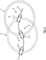
- the follower vehicle 3 uses its own ground radar 6 in order to detect the ground itself and to compare the recorded data with the transmitted map of the leading vehicle 2 and thereby autonomously navigate and avoid the mines 5.
- the data can also be transmitted from one vehicle to the next radar in the case of larger vehicle columns 1.
- the radar is an AESA (Active Electronically Scanned Array) radar.
- the ground radar 6 is preferably arranged on the ground of the leading vehicle 2 or on the ground of the following vehicle 3 such that the detection field extends 360 ° around the vehicle.
- the ground radar 6 is preferably pivotable so that the ground radar 6 can pivot into a horizontal position even when the terrain is rising so that further radiant emission of the radar can be achieved. Furthermore, it can be achieved by the pivoting, when the distance to the follower vehicle 3 is large and this would not otherwise be achieved by the radar field, that the ground radar 6 is pivoted to the following vehicle 3.
- the ground radar 6 may also consist of several radars Radarsensoren exist, which cover different orientations and radiate preferably at an angle between 0 ° and 60 ° relative to the horizon towards the ground.
- the ground radars 6 can alternatively also be arranged on the sides of the vehicle 2, 3 or on the vehicle 2, 3.
Landscapes
- Engineering & Computer Science (AREA)
- Radar, Positioning & Navigation (AREA)
- Remote Sensing (AREA)
- Physics & Mathematics (AREA)
- General Physics & Mathematics (AREA)
- Computer Networks & Wireless Communication (AREA)
- Electromagnetism (AREA)
- Aviation & Aerospace Engineering (AREA)
- Automation & Control Theory (AREA)
- Acoustics & Sound (AREA)
- General Engineering & Computer Science (AREA)
- Traffic Control Systems (AREA)
Applications Claiming Priority (1)
| Application Number | Priority Date | Filing Date | Title |
|---|---|---|---|
| DE102018112376.0A DE102018112376A1 (de) | 2018-05-23 | 2018-05-23 | Unbemanntes Führungsfahrzeug mit einem Bodenradar |
Publications (2)
| Publication Number | Publication Date |
|---|---|
| EP3572840A1 true EP3572840A1 (fr) | 2019-11-27 |
| EP3572840B1 EP3572840B1 (fr) | 2025-09-24 |
Family
ID=66105081
Family Applications (1)
| Application Number | Title | Priority Date | Filing Date |
|---|---|---|---|
| EP19168463.8A Active EP3572840B1 (fr) | 2018-05-23 | 2019-04-10 | Véhicule sans pilote de guidage doté d'un radar au sol |
Country Status (2)
| Country | Link |
|---|---|
| EP (1) | EP3572840B1 (fr) |
| DE (1) | DE102018112376A1 (fr) |
Cited By (3)
| Publication number | Priority date | Publication date | Assignee | Title |
|---|---|---|---|---|
| CN112037552A (zh) * | 2020-08-10 | 2020-12-04 | 北京航空航天大学 | 一种基于5g的矿区无人运输系统的编组协同作业方法 |
| WO2021142016A1 (fr) * | 2020-01-06 | 2021-07-15 | The Trustees Of Indiana University | Train de véhicules autonomes de caravanage |
| CN114942427A (zh) * | 2022-05-13 | 2022-08-26 | 济南大学 | 一种工程机械无人施工的地形识别方法、系统和机械设备 |
Citations (5)
| Publication number | Priority date | Publication date | Assignee | Title |
|---|---|---|---|---|
| US5592170A (en) * | 1995-04-11 | 1997-01-07 | Jaycor | Radar system and method for detecting and discriminating targets from a safe distance |
| US20090079839A1 (en) * | 2006-06-19 | 2009-03-26 | Oshkosh Corporation | Vehicle diagnostics based on information communicated between vehicles |
| US20100256835A1 (en) * | 2009-04-06 | 2010-10-07 | Gm Global Technology Operations, Inc. | Fail-safe speed profiles for cooperative autonomous vehicles |
| US20120062407A1 (en) * | 2007-11-19 | 2012-03-15 | L-3 Communications Cyterra Corporation | Forward-Looking Detection Radar |
| WO2012037680A1 (fr) * | 2010-09-20 | 2012-03-29 | Corporation De L'ecole Polytechnique De Montreal | Système radar avec fonction de communication intégrée |
Family Cites Families (3)
| Publication number | Priority date | Publication date | Assignee | Title |
|---|---|---|---|---|
| DE102010045084A1 (de) * | 2010-09-13 | 2012-03-15 | Rheinmetall Landsysteme Gmbh | Kombinierter Bodenradar und Metalldetektor |
| US9165470B2 (en) * | 2011-07-25 | 2015-10-20 | GM Global Technology Operations LLC | Autonomous convoying technique for vehicles |
| WO2014065856A1 (fr) * | 2012-10-25 | 2014-05-01 | Massachusetts Institute Of Technology | Localisation de véhicule à l'aide d'un radar pénétrant la surface |
-
2018
- 2018-05-23 DE DE102018112376.0A patent/DE102018112376A1/de not_active Withdrawn
-
2019
- 2019-04-10 EP EP19168463.8A patent/EP3572840B1/fr active Active
Patent Citations (5)
| Publication number | Priority date | Publication date | Assignee | Title |
|---|---|---|---|---|
| US5592170A (en) * | 1995-04-11 | 1997-01-07 | Jaycor | Radar system and method for detecting and discriminating targets from a safe distance |
| US20090079839A1 (en) * | 2006-06-19 | 2009-03-26 | Oshkosh Corporation | Vehicle diagnostics based on information communicated between vehicles |
| US20120062407A1 (en) * | 2007-11-19 | 2012-03-15 | L-3 Communications Cyterra Corporation | Forward-Looking Detection Radar |
| US20100256835A1 (en) * | 2009-04-06 | 2010-10-07 | Gm Global Technology Operations, Inc. | Fail-safe speed profiles for cooperative autonomous vehicles |
| WO2012037680A1 (fr) * | 2010-09-20 | 2012-03-29 | Corporation De L'ecole Polytechnique De Montreal | Système radar avec fonction de communication intégrée |
Cited By (6)
| Publication number | Priority date | Publication date | Assignee | Title |
|---|---|---|---|---|
| WO2021142016A1 (fr) * | 2020-01-06 | 2021-07-15 | The Trustees Of Indiana University | Train de véhicules autonomes de caravanage |
| US12603522B2 (en) | 2020-01-06 | 2026-04-14 | The Trustees Of Indiana University | Caravanning autonomous vehicle train |
| CN112037552A (zh) * | 2020-08-10 | 2020-12-04 | 北京航空航天大学 | 一种基于5g的矿区无人运输系统的编组协同作业方法 |
| CN112037552B (zh) * | 2020-08-10 | 2021-06-25 | 北京航空航天大学 | 一种基于5g的矿区无人运输系统的编组协同作业方法 |
| CN114942427A (zh) * | 2022-05-13 | 2022-08-26 | 济南大学 | 一种工程机械无人施工的地形识别方法、系统和机械设备 |
| CN114942427B (zh) * | 2022-05-13 | 2024-06-11 | 济南大学 | 一种工程机械无人施工的地形识别方法、系统和机械设备 |
Also Published As
| Publication number | Publication date |
|---|---|
| EP3572840B1 (fr) | 2025-09-24 |
| DE102018112376A1 (de) | 2019-11-28 |
Similar Documents
| Publication | Publication Date | Title |
|---|---|---|
| AT404302B (de) | Vorrichtung zum orten unterhalb der erdoberfläche befindlicher munition | |
| EP1895318B1 (fr) | Procédé destiné à la détermination de la position globale | |
| DE19704080C2 (de) | Minensuchgerät | |
| DE102018114808A1 (de) | Verfahren zur automatischen Querführung eines Folgefahrzeugs in einem Fahrzeug-Platoon | |
| EP3572840B1 (fr) | Véhicule sans pilote de guidage doté d'un radar au sol | |
| EP3898368B1 (fr) | Procédé et système servant à déterminer une trajectoire corrigée d'un véhicule | |
| EP3526624A1 (fr) | Détection automatisée de l'espace libre par analyse différentielle pour des véhicules | |
| EP3410145B1 (fr) | Procédé d'étalonnage d'un capteur radar d'un véhicule automobile lors d'un mouvement de véhicule automobile, capteur radar, système d'aide à la conduite et véhicule automobile | |
| DE102015119658A1 (de) | Verfahren zum Erfassen eines Umgebungsbereichs eines Kraftfahrzeugs mit Objektklassifizierung, Steuereinrichtung, Fahrerassistenzsystem sowie Kraftfahrzeug | |
| EP3869146A1 (fr) | Procédé de commande pour un capteur radar de missile d'un missile, unité de commande de missile et missile | |
| EP4286243B1 (fr) | Validation d'une unité de détection d'un véhicule ferroviaire pour la localisation d'objets | |
| DE102014221077A1 (de) | Ortungssystem an einem Kraftfahrzeug mit einer Anhängerkupplung | |
| DE102007058241B4 (de) | Auswerteverfahren, insbesondere für ein Fahrerassistenzsystem eines Kraftfahrzeugs, zur Objektdetektion mittels eines Radarsensors | |
| EP3171196A1 (fr) | Procédé et dispositif de détection d'une approche ultérieure ou d'une distance entre deux usagers de la route | |
| WO2012065681A2 (fr) | Atterrissage automatisé de drones | |
| DE102019217555A1 (de) | Verfahren und Steuereinrichtung zur Fahrzeugsteuerung | |
| DE102018126158A1 (de) | Radarmarkierung und Radar | |
| DE102017112210A1 (de) | Verfahren zur Ermittlung der Position einer in einem Suchgebiet befindlichen Landmine | |
| DE102017220004A1 (de) | Verfahren und Fahrerassistenzsystem zum Regeln der Fahrdynamik eines Fahrzeugs | |
| EP0715582B1 (fr) | Procede de localisation des mines marines et de deminage sous-marin | |
| EP4105103B1 (fr) | Dispositif de détection d'environnement à ajustement automatique pour véhicules ferroviaires et procédé correspondant | |
| DE102019218932B3 (de) | Ermitteln einer Relativbewegung | |
| DE102019205481A1 (de) | Umfelderfassung mittels eines Sensors mit variierbarem Erfassungsbereich | |
| DE102011120153A1 (de) | Georadar-Einrichtung | |
| DE102019216536A1 (de) | Verfahren und Steuereinrichtung zur Fahrzeugnavigation |
Legal Events
| Date | Code | Title | Description |
|---|---|---|---|
| PUAI | Public reference made under article 153(3) epc to a published international application that has entered the european phase |
Free format text: ORIGINAL CODE: 0009012 |
|
| STAA | Information on the status of an ep patent application or granted ep patent |
Free format text: STATUS: THE APPLICATION HAS BEEN PUBLISHED |
|
| AK | Designated contracting states |
Kind code of ref document: A1 Designated state(s): AL AT BE BG CH CY CZ DE DK EE ES FI FR GB GR HR HU IE IS IT LI LT LU LV MC MK MT NL NO PL PT RO RS SE SI SK SM TR |
|
| AX | Request for extension of the european patent |
Extension state: BA ME |
|
| STAA | Information on the status of an ep patent application or granted ep patent |
Free format text: STATUS: REQUEST FOR EXAMINATION WAS MADE |
|
| 17P | Request for examination filed |
Effective date: 20200527 |
|
| RBV | Designated contracting states (corrected) |
Designated state(s): AL AT BE BG CH CY CZ DE DK EE ES FI FR GB GR HR HU IE IS IT LI LT LU LV MC MK MT NL NO PL PT RO RS SE SI SK SM TR |
|
| STAA | Information on the status of an ep patent application or granted ep patent |
Free format text: STATUS: EXAMINATION IS IN PROGRESS |
|
| 17Q | First examination report despatched |
Effective date: 20211116 |
|
| RIC1 | Information provided on ipc code assigned before grant |
Ipc: F41H 11/32 20110101ALN20250403BHEP Ipc: G01S 13/02 20060101ALN20250403BHEP Ipc: G05D 1/00 20060101ALI20250403BHEP Ipc: G01S 13/931 20200101ALI20250403BHEP Ipc: G08G 1/00 20060101ALI20250403BHEP Ipc: H04B 7/00 20060101ALI20250403BHEP Ipc: F41H 11/136 20110101ALI20250403BHEP Ipc: G01S 13/87 20060101ALI20250403BHEP Ipc: G01S 13/88 20060101ALI20250403BHEP Ipc: G01S 7/41 20060101ALI20250403BHEP Ipc: G01S 7/00 20060101ALI20250403BHEP Ipc: G01S 13/42 20060101AFI20250403BHEP |
|
| GRAP | Despatch of communication of intention to grant a patent |
Free format text: ORIGINAL CODE: EPIDOSNIGR1 |
|
| STAA | Information on the status of an ep patent application or granted ep patent |
Free format text: STATUS: GRANT OF PATENT IS INTENDED |
|
| INTG | Intention to grant announced |
Effective date: 20250515 |
|
| GRAS | Grant fee paid |
Free format text: ORIGINAL CODE: EPIDOSNIGR3 |
|
| GRAA | (expected) grant |
Free format text: ORIGINAL CODE: 0009210 |
|
| STAA | Information on the status of an ep patent application or granted ep patent |
Free format text: STATUS: THE PATENT HAS BEEN GRANTED |
|
| AK | Designated contracting states |
Kind code of ref document: B1 Designated state(s): AL AT BE BG CH CY CZ DE DK EE ES FI FR GB GR HR HU IE IS IT LI LT LU LV MC MK MT NL NO PL PT RO RS SE SI SK SM TR |
|
| REG | Reference to a national code |
Ref country code: GB Ref legal event code: FG4D Free format text: NOT ENGLISH |
|
| REG | Reference to a national code |
Ref country code: CH Ref legal event code: EP |
|
| REG | Reference to a national code |
Ref country code: DE Ref legal event code: R096 Ref document number: 502019013915 Country of ref document: DE |
|
| REG | Reference to a national code |
Ref country code: IE Ref legal event code: FG4D Free format text: LANGUAGE OF EP DOCUMENT: GERMAN |
|
| PG25 | Lapsed in a contracting state [announced via postgrant information from national office to epo] |
Ref country code: NO Free format text: LAPSE BECAUSE OF FAILURE TO SUBMIT A TRANSLATION OF THE DESCRIPTION OR TO PAY THE FEE WITHIN THE PRESCRIBED TIME-LIMIT Effective date: 20251224 |
|
| REG | Reference to a national code |
Ref country code: LT Ref legal event code: MG9D |
|
| PG25 | Lapsed in a contracting state [announced via postgrant information from national office to epo] |
Ref country code: FI Free format text: LAPSE BECAUSE OF FAILURE TO SUBMIT A TRANSLATION OF THE DESCRIPTION OR TO PAY THE FEE WITHIN THE PRESCRIBED TIME-LIMIT Effective date: 20250924 |
|
| PG25 | Lapsed in a contracting state [announced via postgrant information from national office to epo] |
Ref country code: HR Free format text: LAPSE BECAUSE OF FAILURE TO SUBMIT A TRANSLATION OF THE DESCRIPTION OR TO PAY THE FEE WITHIN THE PRESCRIBED TIME-LIMIT Effective date: 20250924 |
|
| PG25 | Lapsed in a contracting state [announced via postgrant information from national office to epo] |
Ref country code: GR Free format text: LAPSE BECAUSE OF FAILURE TO SUBMIT A TRANSLATION OF THE DESCRIPTION OR TO PAY THE FEE WITHIN THE PRESCRIBED TIME-LIMIT Effective date: 20251225 |
|
| PG25 | Lapsed in a contracting state [announced via postgrant information from national office to epo] |
Ref country code: SE Free format text: LAPSE BECAUSE OF FAILURE TO SUBMIT A TRANSLATION OF THE DESCRIPTION OR TO PAY THE FEE WITHIN THE PRESCRIBED TIME-LIMIT Effective date: 20250924 |
|
| PG25 | Lapsed in a contracting state [announced via postgrant information from national office to epo] |
Ref country code: LV Free format text: LAPSE BECAUSE OF FAILURE TO SUBMIT A TRANSLATION OF THE DESCRIPTION OR TO PAY THE FEE WITHIN THE PRESCRIBED TIME-LIMIT Effective date: 20250924 |
|
| PG25 | Lapsed in a contracting state [announced via postgrant information from national office to epo] |
Ref country code: BG Free format text: LAPSE BECAUSE OF FAILURE TO SUBMIT A TRANSLATION OF THE DESCRIPTION OR TO PAY THE FEE WITHIN THE PRESCRIBED TIME-LIMIT Effective date: 20250924 |
|
| PG25 | Lapsed in a contracting state [announced via postgrant information from national office to epo] |
Ref country code: RS Free format text: LAPSE BECAUSE OF FAILURE TO SUBMIT A TRANSLATION OF THE DESCRIPTION OR TO PAY THE FEE WITHIN THE PRESCRIBED TIME-LIMIT Effective date: 20251224 |
|
| REG | Reference to a national code |
Ref country code: NL Ref legal event code: MP Effective date: 20250924 |
|
| PG25 | Lapsed in a contracting state [announced via postgrant information from national office to epo] |
Ref country code: NL Free format text: LAPSE BECAUSE OF FAILURE TO SUBMIT A TRANSLATION OF THE DESCRIPTION OR TO PAY THE FEE WITHIN THE PRESCRIBED TIME-LIMIT Effective date: 20250924 |
|
| PG25 | Lapsed in a contracting state [announced via postgrant information from national office to epo] |
Ref country code: SM Free format text: LAPSE BECAUSE OF FAILURE TO SUBMIT A TRANSLATION OF THE DESCRIPTION OR TO PAY THE FEE WITHIN THE PRESCRIBED TIME-LIMIT Effective date: 20250924 |
|
| PG25 | Lapsed in a contracting state [announced via postgrant information from national office to epo] |
Ref country code: ES Free format text: LAPSE BECAUSE OF FAILURE TO SUBMIT A TRANSLATION OF THE DESCRIPTION OR TO PAY THE FEE WITHIN THE PRESCRIBED TIME-LIMIT Effective date: 20250924 |
|
| PG25 | Lapsed in a contracting state [announced via postgrant information from national office to epo] |
Ref country code: IT Free format text: LAPSE BECAUSE OF FAILURE TO SUBMIT A TRANSLATION OF THE DESCRIPTION OR TO PAY THE FEE WITHIN THE PRESCRIBED TIME-LIMIT Effective date: 20250924 |
|
| PG25 | Lapsed in a contracting state [announced via postgrant information from national office to epo] |
Ref country code: IS Free format text: LAPSE BECAUSE OF FAILURE TO SUBMIT A TRANSLATION OF THE DESCRIPTION OR TO PAY THE FEE WITHIN THE PRESCRIBED TIME-LIMIT Effective date: 20260124 |
|
| PG25 | Lapsed in a contracting state [announced via postgrant information from national office to epo] |
Ref country code: PT Free format text: LAPSE BECAUSE OF FAILURE TO SUBMIT A TRANSLATION OF THE DESCRIPTION OR TO PAY THE FEE WITHIN THE PRESCRIBED TIME-LIMIT Effective date: 20260126 Ref country code: CZ Free format text: LAPSE BECAUSE OF FAILURE TO SUBMIT A TRANSLATION OF THE DESCRIPTION OR TO PAY THE FEE WITHIN THE PRESCRIBED TIME-LIMIT Effective date: 20250924 |
|
| PG25 | Lapsed in a contracting state [announced via postgrant information from national office to epo] |
Ref country code: PL Free format text: LAPSE BECAUSE OF FAILURE TO SUBMIT A TRANSLATION OF THE DESCRIPTION OR TO PAY THE FEE WITHIN THE PRESCRIBED TIME-LIMIT Effective date: 20250924 |
|
| PG25 | Lapsed in a contracting state [announced via postgrant information from national office to epo] |
Ref country code: SK Free format text: LAPSE BECAUSE OF FAILURE TO SUBMIT A TRANSLATION OF THE DESCRIPTION OR TO PAY THE FEE WITHIN THE PRESCRIBED TIME-LIMIT Effective date: 20250924 Ref country code: EE Free format text: LAPSE BECAUSE OF FAILURE TO SUBMIT A TRANSLATION OF THE DESCRIPTION OR TO PAY THE FEE WITHIN THE PRESCRIBED TIME-LIMIT Effective date: 20250924 |