EP3967980A2 - Routenverarbeitungsverfahren und -vorrichtung - Google Patents
Routenverarbeitungsverfahren und -vorrichtung Download PDFInfo
- Publication number
- EP3967980A2 EP3967980A2 EP21217572.3A EP21217572A EP3967980A2 EP 3967980 A2 EP3967980 A2 EP 3967980A2 EP 21217572 A EP21217572 A EP 21217572A EP 3967980 A2 EP3967980 A2 EP 3967980A2
- Authority
- EP
- European Patent Office
- Prior art keywords
- road section
- definition map
- target
- high definition
- route
- Prior art date
- Legal status (The legal status is an assumption and is not a legal conclusion. Google has not performed a legal analysis and makes no representation as to the accuracy of the status listed.)
- Granted
Links
Images



Classifications
-
- G—PHYSICS
- G01—MEASURING; TESTING
- G01C—MEASURING DISTANCES, LEVELS OR BEARINGS; SURVEYING; NAVIGATION; GYROSCOPIC INSTRUMENTS; PHOTOGRAMMETRY OR VIDEOGRAMMETRY
- G01C21/00—Navigation; Navigational instruments not provided for in groups G01C1/00 - G01C19/00
- G01C21/26—Navigation; Navigational instruments not provided for in groups G01C1/00 - G01C19/00 specially adapted for navigation in a road network
- G01C21/34—Route searching; Route guidance
- G01C21/3407—Route searching; Route guidance specially adapted for specific applications
-
- G—PHYSICS
- G01—MEASURING; TESTING
- G01C—MEASURING DISTANCES, LEVELS OR BEARINGS; SURVEYING; NAVIGATION; GYROSCOPIC INSTRUMENTS; PHOTOGRAMMETRY OR VIDEOGRAMMETRY
- G01C21/00—Navigation; Navigational instruments not provided for in groups G01C1/00 - G01C19/00
- G01C21/26—Navigation; Navigational instruments not provided for in groups G01C1/00 - G01C19/00 specially adapted for navigation in a road network
- G01C21/34—Route searching; Route guidance
- G01C21/36—Input/output arrangements for on-board computers
- G01C21/3667—Display of a road map
-
- G—PHYSICS
- G01—MEASURING; TESTING
- G01C—MEASURING DISTANCES, LEVELS OR BEARINGS; SURVEYING; NAVIGATION; GYROSCOPIC INSTRUMENTS; PHOTOGRAMMETRY OR VIDEOGRAMMETRY
- G01C21/00—Navigation; Navigational instruments not provided for in groups G01C1/00 - G01C19/00
- G01C21/26—Navigation; Navigational instruments not provided for in groups G01C1/00 - G01C19/00 specially adapted for navigation in a road network
- G01C21/28—Navigation; Navigational instruments not provided for in groups G01C1/00 - G01C19/00 specially adapted for navigation in a road network with correlation of data from several navigational instruments
- G01C21/30—Map- or contour-matching
-
- G—PHYSICS
- G01—MEASURING; TESTING
- G01C—MEASURING DISTANCES, LEVELS OR BEARINGS; SURVEYING; NAVIGATION; GYROSCOPIC INSTRUMENTS; PHOTOGRAMMETRY OR VIDEOGRAMMETRY
- G01C21/00—Navigation; Navigational instruments not provided for in groups G01C1/00 - G01C19/00
- G01C21/26—Navigation; Navigational instruments not provided for in groups G01C1/00 - G01C19/00 specially adapted for navigation in a road network
- G01C21/34—Route searching; Route guidance
- G01C21/3407—Route searching; Route guidance specially adapted for specific applications
- G01C21/3415—Dynamic re-routing, e.g. recalculating the route when the user deviates from calculated route or after detecting real-time traffic data or accidents
-
- G—PHYSICS
- G01—MEASURING; TESTING
- G01C—MEASURING DISTANCES, LEVELS OR BEARINGS; SURVEYING; NAVIGATION; GYROSCOPIC INSTRUMENTS; PHOTOGRAMMETRY OR VIDEOGRAMMETRY
- G01C21/00—Navigation; Navigational instruments not provided for in groups G01C1/00 - G01C19/00
- G01C21/26—Navigation; Navigational instruments not provided for in groups G01C1/00 - G01C19/00 specially adapted for navigation in a road network
- G01C21/34—Route searching; Route guidance
- G01C21/3446—Details of route searching algorithms, e.g. Dijkstra, A*, arc-flags or using precalculated routes
-
- G—PHYSICS
- G01—MEASURING; TESTING
- G01C—MEASURING DISTANCES, LEVELS OR BEARINGS; SURVEYING; NAVIGATION; GYROSCOPIC INSTRUMENTS; PHOTOGRAMMETRY OR VIDEOGRAMMETRY
- G01C21/00—Navigation; Navigational instruments not provided for in groups G01C1/00 - G01C19/00
- G01C21/26—Navigation; Navigational instruments not provided for in groups G01C1/00 - G01C19/00 specially adapted for navigation in a road network
- G01C21/34—Route searching; Route guidance
- G01C21/36—Input/output arrangements for on-board computers
- G01C21/3605—Destination input or retrieval
- G01C21/3614—Destination input or retrieval through interaction with a road map, e.g. selecting a POI icon on a road map
-
- G—PHYSICS
- G01—MEASURING; TESTING
- G01C—MEASURING DISTANCES, LEVELS OR BEARINGS; SURVEYING; NAVIGATION; GYROSCOPIC INSTRUMENTS; PHOTOGRAMMETRY OR VIDEOGRAMMETRY
- G01C21/00—Navigation; Navigational instruments not provided for in groups G01C1/00 - G01C19/00
- G01C21/38—Electronic maps specially adapted for navigation; Updating thereof
-
- G—PHYSICS
- G06—COMPUTING OR CALCULATING; COUNTING
- G06F—ELECTRIC DIGITAL DATA PROCESSING
- G06F16/00—Information retrieval; Database structures therefor; File system structures therefor
- G06F16/20—Information retrieval; Database structures therefor; File system structures therefor of structured data, e.g. relational data
- G06F16/29—Geographical information databases
-
- G—PHYSICS
- G06—COMPUTING OR CALCULATING; COUNTING
- G06F—ELECTRIC DIGITAL DATA PROCESSING
- G06F16/00—Information retrieval; Database structures therefor; File system structures therefor
- G06F16/90—Details of database functions independent of the retrieved data types
- G06F16/95—Retrieval from the web
- G06F16/953—Querying, e.g. by the use of web search engines
- G06F16/9537—Spatial or temporal dependent retrieval, e.g. spatiotemporal queries
Definitions
- the present disclosure relates to the field of automatic driving in computer technology, and in particular to a route processing method and apparatus.
- route planning is usually based on standard definition maps. Then, according to the mapping relationship between the standard definition map and the high definition map, a matched route of a planned route is determined in the high definition map.
- certain errors will exist between the standard definition map and the high definition map, resulting in that the road sections of the two maps are not necessarily completely corresponding.
- one corresponding road section is chosen randomly in multiple corresponding road sections for autonomous driving.
- the randomly selected road section may not conform to the vehicle driving road section users needed. Therefore, when implementing automatic driving based on the high definition maps, there is a problem that the accuracy of the matched route is not high.
- the present disclosure provides a route processing method and apparatus. According to the first aspect of the present disclosure, provided is a route processing method, including:
- a route processing apparatus including:
- an electrical device including:
- a non-transitory computer-readable storage medium storing computer instructions, where the computer instructions are used to enable a computer to execute the methods according to the first aspect.
- the computer program product includes a computer program which is stored in a computer-readable storage medium, at least one processor of the electrical device can read the computer program stored from the computer-readable storage medium, the computer program is executed by the at least one processor to enable the electrical device to execute the methods according to the first aspect.
- the technology according to the present disclosure solves the problem of low accuracy of the matched route in high definition maps.
- the automatic driving technology usually needs to be implemented based on the standard definition map (SD map) and the high definition map (HD map). Firstly, the high definition map will be briefly described as follows.
- the high definition map refers to a high definition, refined-defined map.
- the high definition map will allow the automatic driving to have a wider field of view to see more clearly and in a more timely manner, which plays a role in constructing the overall memory and cognition of space similar to the human brain and has the functions of positioning, decision-making assistance, and navigation.
- the high definition map can provide complete lane information, based on the "over-the-horizon perception" brought by the high definition map, and can be compared with the information recognized by the sensor, so as to achieve high definition positioning, ensure safety, and provide reference information on the feasibility of lane changing, which becomes an indispensable safety redundancy scheme.
- POI point of interest
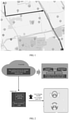
- FIG. 1 is a schematic diagram of a planned route in a standard definition map provided by an embodiment of the present disclosure.
- the vehicle side can obtain a planned route between starting point A and ending point B based on the standard definition map, for example, it can arbitrarily be the route shown by the arrow in FIG. 1 .
- a matched route of the current route in the high definition map can be determined through the mapping relationship between the standard definition map and the high definition map stored in the cloud side, and then autonomous driving of vehicle is realized based on the matched route in the high definition map.
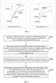
- FIG. 2 is a schematic diagram of a system of a route processing method provided by an embodiment of the present disclosure.
- the road network of the two maps can be matched in the cloud side in advance to obtain a mapping table of the high definition map and standard definition map, the correspondence between each road section in the high definition map and each road section in the standard definition map can be included in the mapping table.
- the vehicle side can query the mapping table described above through the cloud side to determine the part of the current standard definition map planned route that contains the high definition map, and then for the part containing the high definition map, associate according to the mapping table and high definition map, to determine a driving route in the high definition map, and follow the driving route in the high definition map for automatic driving.
- the vehicle side can turn on the Auto Navigation Pilot (ANP) function.
- APN Auto Navigation Pilot
- the vehicle side can carry out automatic driving route planning and determine the route calculation result, etc., based on the driving route in the high definition map, and then assist, based on the relevant information in the high definition map, the vehicle to realize automatic driving, such as providing the vehicle with lane changing reminder, lane changing guide line, etc.
- the automatic driving is carried out on the vehicle side, in addition to the auto navigation pilot described above, if condition permits, for example, the automatic driving can be completely performed by the vehicle side, where the specific implementation of the automatic driving can be selected according to the actual needs, this embodiment does not limit it.
- the current map matching between two maps is based on the corresponding relationship determined by the mapping table between the two maps.
- the road network structure and the road topological connection relationship between the standard definition map and the high definition map are not exactly the same.
- FIG. 3 is a schematic diagram of road sections in a standard definition map and a high definition map provided by an embodiment of the present disclosure.
- FIG. 3 shows the different implementations of several road sections in the same area in the standard definition map and the high definition map.
- road section H200 and road section H300 are independently mounted on road section HD100 and road section HD101, respectively.
- road section S300 and road section S301 are connected to road section S200 simultaneously.
- one road section is usually selected randomly among multiple corresponding road sections for the automatic driving.
- S200 corresponds to both H101 and H200
- one road section will be randomly selected between H101 and H200.
- the random selection method may lead to the wrong driving route.
- the current route H101 is randomly selected, but the user actually needs the vehicle to drive on the road section H200. Therefore, when the current related technology realizes the automatic driving based on the high definition map, there is a problem that the accuracy of the driving path is not high.
- the present disclosure proposes the following technical idea: when the planned route in the standard definition map is matched with the high definition map, the matched road section in the high definition map is determined merely for the road section with a unique mapping relationship. For fuzzy road section with unclear mapping relationships, fill in the road section according to the road section with a unique mapping relationship and the high definition map, to obtain the final matched road section, which can effectively improve the route accuracy of the automatic driving.
- each embodiment of the present disclosure may be the cloud side introduced above, or may also be the vehicle side introduced above.
- the embodiment does not impose a restriction on this, that is to say, the route matching between the two maps is performed by the vehicle side.
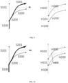
- FIG. 4 is a flowchart of a route processing method provided by an embodiment of the present disclosure.
- the method includes: S401, acquiring a vehicle driving route according to a standard definition map, where the vehicle driving route comprises multiple standard definition map road sections of the standard definition map.
- the vehicle driving route can first be obtained based on a standard definition map.
- a route can be planned in a standard definition map based on the starting point and ending point to determine the vehicle driving route.
- the vehicle driving route can include multiple standard definition map road sections, these standard definition map road sections are all road sections in the standard definition map.
- a first road section can be determined from the multiple standard definition map road sections of the vehicle driving route according to the road section mapping relationship between the standard definition map and the high definition map stored in the cloud side.
- the road section mapping relationship includes the mapping relationship between at least one road section in the standard definition map and at least one road section in the high definition map.
- the specific road section mapping relationship depends on the specific implementation of the standard definition map and the high definition map, which is not limited in this embodiment.
- the first road section is a road section that has a unique mapping relationship in the road section mapping relationship, that is, each first road section has a unique corresponding target road section in the high definition map.
- determining the first road section among multiple standard definition map road sections is equivalent to first extracting the road section with a unique mapping relationship among the multiple standard definition map road sections.
- the road section mapping relationship includes the mapping relationship between the respective road section in the standard definition map and the respective road section in the high definition map, so after determining the first road section, the target road section corresponding to each first road section in the high definition map can be determined according to the road section mapping relationship stored in the cloud side.
- each first road section Since the mapping relationship of each first road section is unique, the currently determined target road section corresponding to each first road section can be guaranteed to be correct.
- the remaining uncertain road sections can be automatically filled according to the target road section corresponding to each first road section and the high definition map, so as to determine the target driving route corresponding to the vehicle driving route in the high definition map.
- the target driving route includes the target road section corresponding to each first road section, and also includes the filling road section determined according to the target road section corresponding to each first road section and the high definition map, it should be understood that the filling road section is a road section other than the target road section in the finally determined target driving route.
- a unique route can be determined in the high definition map according to target road section respectively corresponding to the first road section. If so, the filling road section can be directly determined. If the unique route cannot be determined, for example, the filling road section can be determined based on the real-time planned route of the vehicle. For example, at least one filling road section can be determined by map matching of the track point and the road network.
- the target road section corresponding to the first road section can be first determined according to the first road section which determines the unique matching relationship, and then fill the remaining road section according to the target road section whose accuracy can be ensured and the high definition map, so that the target driving route corresponding to the vehicle driving route is accurately and effectively determined in the high definition map.
- the execution body in this embodiment can be the cloud side or the vehicle side, because the road section mapping relationship is stored in the cloud side described above, then when the execution body of this embodiment is the cloud side, the cloud side can directly perform corresponding processing according to the road section mapping relationship stored in the cloud side; when the execution body is the vehicle side, the vehicle side can access the road section mapping relationship in the cloud side to perform corresponding processing, or it can receive the data issued by the network from the cloud side to perform corresponding processing.
- This embodiment does not limit the specific execution body, which can be selected according to actual needs.
- the vehicle side after obtaining the target driving route, can, for example, perform the automatic driving according to the target driving route in the high definition map, or perform the automatic assistance driving, such as providing some pieces of driving assistance information, etc., which is not limited in this embodiment.
- the route processing method provided by the present disclosure includes: acquiring a vehicle driving route according to a standard definition map, where the vehicle driving route comprises multiple standard definition map road sections of the standard definition map, determining at least one first road section from the multiple standard definition map road sections according to a road section mapping relationship between the standard definition map and a high definition map, where each first road section has a unique corresponding target road section in the high definition map, determining the target road section corresponding to each first road section in the high definition map according to the road section mapping relationship, and determining a target driving route corresponding to the vehicle driving route in the high definition map according to the target road section corresponding to each first road section and the high definition map, where the target driving route comprises each target road section and a filling road section, and the filling road section is a road section other than the target road section in the target driving route.
- FIG. 5 is a second flowchart of a route processing method provided by an embodiment of the present disclosure
- FIG. 6 is a schematic diagram of a possible implementation of the road section mapping relationship provided by an embodiment of the present disclosure.
- FIG. 7 is a schematic diagram of an implementation of the driving route of a vehicle provided by an embodiment of the present disclosure.
- FIG. 8 is a schematic diagram of another possible implementation of the road section mapping relationship provided by an embodiment of the present disclosure.
- FIG. 9 is a schematic diagram of a possible implementation for determining a target driving route provided by an embodiment of the present disclosure.
- FIG. 10 is another possible implementation schematic diagram for determining the target driving route provided by an embodiment of the present disclosure.
- the method includes: S501, acquiring a vehicle driving route according to a standard definition map, where the vehicle driving route comprises multiple standard definition map road sections of the standard definition map.
- S501 is similar to that of S401, which will not be repeated here.
- S502 is similar to that of S402 described above. Here, the implementation of S502 will be further explained in combination with FIG. 6 and FIG. 7 .
- the road section mapping relationship may be stored in the cloud side, and the road section mapping relationship may store the mapping relationship between each road section in the standard definition map and each road section in the high definition map, what can be determined based on the above introduction is that there may be a unique mapping relationship between the road section in the standard definition map and the road section in the high definition map, or there may be multiple mapping relationships such as many-to-one, one-to-many, and many-to-many.
- the road section mapping relationship may include, for example, only the unique road section mapping relationship between the road section in the standard definition map and the road section on the high definition map.
- FIG. 6 includes the corresponding relationship between each road section in the standard definition map and each road section in the high definition map. It worth noting that, the unique corresponding relationship described in the present embodiment, is not meant to say that a road section of the standard definition map and a certain road section of the high definition map have a complete one-to-one correspondence. It can be that a certain part of a certain road section in the standard definition map and a certain part of a certain road section in the high definition map are uniquely corresponding, thus the road section mapping relationship can also include the corresponding starting position offset and ending position offset between the road sections.
- the entire road section of the road section S100 corresponds to the entire road section of the road section H100
- the 30%-100% part of the road section S101 corresponds to the entire road section of the road section H102
- the entire section S300 corresponds to the 20%-100% part of the entire section H200
- the entire road section of the road section S301 corresponds to the 30%-100% part of the road section H300.
- each standard definition map road section can be searched in the road section mapping relationship and the standard definition map road section searched in the road section mapping relationship can be determined as the first road section.
- the first road section that needs to be currently determined is a standard definition map road section that has a unique corresponding road section in the high definition map, and under the current implementation, the unique mapping relationship between road sections is stored in the road section mapping relationship, thus as long as the standard definition map road section can be searched in the road section mapping relationship, the standard definition map road section can be determined as the first road section.
- the current vehicle driving route determined in the standard definition map is the route indicated by 70 in FIG. 7 .
- the vehicle driving route 70 includes three standard definition map road sections which are road section S100, road section S200 and road section S301 respectively.
- the road section S100, the road section S200, and the road section S301 can be searched in the road section mapping relationship described in FIG. 6 , and it can be determined that the road section S100 and the road section S301 are included in FIG. 6 , but the road section S200 is not included. It is determined that the first road section includes road section S100 and road section S301.
- the road section mapping relationship can also include the mapping relationship of all the road sections between the road section of the standard definition map and the road section of the high definition map, that is, not only can include the unique mapping relationship, but also can include the one-to-many, many-to-one, and many-to-many mapping relationships.
- the road section mapping relationship may as illustrated in FIG. 8 .
- FIG. 8 includes all the correspondences between each road section in the standard definition map and each road section in the high definition map.
- the road section mapping relationship can also include the corresponding starting position offset and ending position offset between the road sections.
- the entire road section of the road section S100 correspond to the entire road section of the road section H100; the 30%-100% part of the road section S101 corresponds to the entire road section of the road section H102; the entire road section of the road section S300 corresponds to the 20%-100% part of the road section H200; the entire section of the road section S301 corresponds to the 30%-100% part of the road section H300; the entire section of the road section S200 corresponds to the 0%-20% part of the road section H200; the 0%-50% part of the road section S200 corresponds to the entire section of the road section H101; the 50%-100% part of road section S200 corresponds to the 0%-30% part of the road section H300.
- a road section having a unique mapping relationship with the standard definition map road section can be searched from the road section of the mapping relationship, the road section with a unique mapping relationship is determined as the first road section.
- the first road section that needs to be determined currently is a standard definition map road section that has a unique corresponding road section in the high definition map, and under the current implementation, the correspondences among all road sections are stored in the road section mapping relationship. Therefore, it is necessary to search a road section in the standard definition map with a unique corresponding relationship in the road section mapping relationship, so as to determine the first road section.
- the current vehicle driving route determined in the standard definition map is the route indicated by 70 in FIG. 7 .
- the vehicle driving route 70 includes three standard definition map road sections which are road section S100, road section S200 and road section S301 respectively.
- the road section mapping relationship specifically includes merely the unique corresponding relationship between the road sections, or includes all the corresponding relationships between the road sections can be selected according to actual needs, and the specific implementation of the road section mapping relationship thereof can also be selected according to actual needs, this embodiment does not make special restrictions on this.
- the processing flexibility in the route determining process can be effectively improved.
- Specific implementation can be selected according to actual needs.
- the target road section corresponding to each first road section can be determined according to the road section mapping relationship.
- the target road section is the road section in the high definition map.
- the determining a target driving route corresponding to the vehicle driving route in the high definition map according to the target road section corresponding to each first road section and the high definition map may be first determining at least one candidate route comprising each target road section in the high definition map according to the target road section corresponding to each first road section.
- each first road section is a road section whose accuracy can be ensured
- at least one candidate route including each target road section can be determined in the high precision map.
- At least one filling road section that can connect each target road section can be determined according to the topological connection relationship between each target road section, and each target road section and the filling road section are included in the candidate route.
- An implementation of a filling road section corresponds to a candidate route.
- the currently determined filling road sections are 1, 2, 3, which correspond to a candidate route; for another example, the currently determined filling road sections are 2, 3, 4, which correspond to another candidate route.
- the endpoints (starting point and ending point) of the candidate route in the high definition map in this embodiment are the same as the endpoints (starting point and ending point) of the vehicle driving route in the standard definition map, which can effectively ensure that the target driving route finally determined based on the candidate route matches the vehicle driving route.
- the second coordinate positions in the high definition map corresponding to the first coordinate positions can be found in the high definition map, so that the starting point and the ending point in the high definition map can be determined according to the second coordinate positions, and at least one candidate route including each target road section can be determined within the range of the starting point and the ending point in the high definition map.
- the specific judgment method can be selected according to actual needs, as long as the number of current candidate routes can be determined.
- the candidate route can be directly determined as the target driving route.
- the filling road section is the only road section connecting each target road section.
- the vehicle driving route 90 includes road section S100, road section S200, and road section S301. Based on the above introduction, it can be determined that the road section S100 and road section S301 are the first road sections.
- the target road section corresponding to the first road section S100 in the high definition map is H100
- the target road section corresponding to the first road section S301 in the high definition map is H300, so the target driving route can be currently determined based on the topological connection relationship of H100 and H300 in the high definition map.
- road section H101 can be determined as the only filling road section, so as to determine the target driving route in the high definition the map, and the target driving route includes road sections H100, H101 and H300.
- the target road section corresponding to the first road section with a unique mapping relationship is first determined, and then according to the topological connection relationship of each target road section, the filling road section that can connect each target road section is determined, when there is only one way to implement the filling road section, so that the target driving section can be accurately and effectively determined.
- the number of the candidate routes is determined to be multiple, it means that there are multiple topological connections between the current target routes. Therefore, the way to determine the filling road section in between is not unique, so further determination of the filling road section is needed.
- a first road section with a unique mapping relationship is determined among multiple standard definition map road sections, and the road section other than the first road section in the standard definition map road sections is determined as the second road section.
- each second road section is a road section with an unclear correspondence relationship.
- multiple candidate routes are determined.
- the multiple candidate routes can include the target road section corresponding to each second road section. Therefore, the target road section corresponding to each second road section in each candidate route can be determined.
- map matching can be performed on each candidate route according to the track points of each second road section, so as to determine the target road section corresponding to each second road section.
- the map matching can be achieved based on the distance and angle between the track points and the road sections
- the distance and angle between each track point and each road section to be matched in the candidate route can be determined according to the position and direction of each track point included in the second road section.
- the road section to be matched is the road section in the candidate route excluding each target road section. It should be understood that since the target road section has been determined to be the road section corresponding to each first road section, it can no longer correspond to the second road section. Therefore, there is no need to perform map matching for each target road section, only the map matching of the road sections other than the target road section need to be performed, which can effectively reduce the amount of data that needs to be processed.
- At least one matched road section that matches the second road section can be determined according to the distance and angle between each track point and each road section to be matched.
- the distance and angle between the track point and the road section to be matched can be input into a preset function, so as to obtain the probability of each track point matching the corresponding road section to be matched, and then the matched road section corresponding to the second road section is determined according to the matching probability corresponding to each track point.
- a preset function so as to obtain the probability of each track point matching the corresponding road section to be matched, and then the matched road section corresponding to the second road section is determined according to the matching probability corresponding to each track point.
- the matched road section that matches the second road section may be determined as the target road section corresponding to the second road section in the high definition map.
- the current vehicle driving route determined in the standard definition map is the route indicated by 100 in FIG. 10
- the vehicle driving route 100 includes road section S100, road section S200, and road section S301.
- the road section S100 and road section S301 are the first road sections
- S200 of the road section can be the second road section.
- the target road section corresponding to the first road section S100 in the high definition map is H100
- the target road section corresponding to the first road section S301 in the high definition map is H300, so the target driving route can be determined based on the topological connection relationship of H100 and H300 in the high definition map currently.
- both road sections H101 and H400 can realize the connection in between. Therefore, two candidate routes can be determined, namely a candidate route composed of road sections H100, H101 and H300, and a candidate route composed of road section H100, road section H400 and road section H300.
- the map matching can be performed on the road section to be matched in the candidate route.
- road section H101 is the road section to be matched.
- road section H400 is the road section to be matched, and the two road sections to be matched can be matched according to the track points of road section S200.
- the road section with closer distance and angle to the track points of S200 is road section H101, so the matched road section that matches road section S200 is H101, and then H101 can be determined as the target road section corresponding to road section S200
- the target road section corresponding to each standard definition map road section included in the vehicle driving route is obtained. Therefore, a driving route composed of a target road section corresponding to each first road section and a target road section corresponding to each second road section can be determined as the target driving route.
- the driving route composed of the target road sections H100 and H300 corresponding to the first road sections and the target road section H101 corresponding to the second road section is the target driving route in the high definition map.
- the route processing method provided by the embodiments of the present disclosure provides different setting methods for the road section mapping relationship, for example, it may merely include the unique mapping relationship, or it may also include all the road section mapping relationships, thereby improving the flexibility of route processing. And determining the candidate route according to the topological connection relationship between the corresponding target road sections of each first road section, when there is only one candidate route, the candidate route can be accurately and efficiently determined as the target driving route, and while there are multiple candidate routes, the target road section corresponding to the each second road section can be accurately determined through the map matching, and then the target driving route in the high definition map can be obtained, which can effectively improve the accuracy of determining the driving route in the high definition map.
- FIG. 11 is a schematic structural diagram of a route processing apparatus according to an embodiment of the present disclosure. As illustrated in FIG. 11 , the route processing apparatus according to an embodiment of this embodiment 1100 may include: an acquiring module 1101, a first determining module 1102, a second determining module 1103, a third determining module 1104.
- the acquiring module 1101 is configured to acquire a vehicle driving route according to a standard definition map, where the vehicle driving route comprises multiple standard definition map road sections of the standard definition map;
- the first determining module 1102 is configured to determine at least one first road section from the multiple standard definition map road sections according to a road section mapping relationship between the standard definition map and a high definition map, where each first road section has a unique corresponding target road section in the high definition map;
- the third determining module 1104 includes:
- the second processing unit is specifically configured to: determine the candidate route as the target driving route when the number of the candidate route is one, where the filling road section is a unique road section connecting each target road section.
- the second processing unit is specifically configured to:
- the second processing unit is specifically configured to:
- the road section mapping relationship comprises a unique road section mapping relationship between a road section of the standard definition map and a road section of the high definition map; the first determining module 1102 is specifically configured to: search for each standard definition map road section in the road section mapping relationship, and determine the standard definition map road section searched in the road section mapping relationship as the first road section.
- the road section mapping relationship comprises all road section mapping relationships between a road section of the standard definition map and a road section of the high definition map; the first determining module 1102 is specifically configured to: search for, among the road section mapping relationships, a road section having a unique mapping relationship with the standard definition map road section, and determine the road section having the unique mapping relationship as the first road section.
- the present disclosure provides a route processing method and apparatus, which are applied in the field of automatic driving in computer technology to achieve the purpose of improving the accuracy of the matched route in the high definition map.
- the present disclosure also provides an electronic device and a readable storage medium.
- the present disclosure also provides a computer program product, which includes: a computer program, the computer program is stored in a readable storage medium, at least one processor of the electrical device can read the computer program stored from the computer-readable storage medium, the computer program is executed by the at least one processor to enable the electrical device to execute the solution provided by any of the above embodiments.
- FIG. 12 shows a schematic block diagram of an exemplary electronic device 1200 that can be used to implement an embodiment of the present disclosure.
- Electronic devices are intended to represent various forms of digital computers, such as laptop computers, desktop computers, workstations, personal digital assistants, servers, blade servers, mainframe computers, and other suitable computers.
- Electronic devices can also represent various forms of mobile devices, such as personal digital processing, cellular phones, smart phones, wearable devices, and other similar computing devices.
- the components shown herein, their connections and relationships, and their functions are merely examples, and are not intended to limit the implementation of the present disclosure described and/or required herein.
- the electronic device 1200 includes a computing unit 1201, which can be based on a computer program stored in a read only memory (ROM) 1202 or loaded from a storage unit 1208 to a random access memory (RAM) 1203 to perform various appropriate actions and processing.
- ROM read only memory
- RAM random access memory
- various programs and data required for the operation of the device 1200 can also be stored.
- the computing unit 1201, the ROM 1202, and the RAM 1203 are connected to each other through a bus 1204.
- the input/output (I/O) interface 1205 is also connected to the bus 1204.
- the I/O interface 1205 includes: an inputting unit 1206, such as a keyboard, a mouse, etc.; an outputting unit 1207, such as various types of displays, speakers, etc.; and a storage unit 1208, such as a disk, optical disc, etc.; and communication unit 1209, such as network card, modem, wireless communication transceiver, etc.
- the communication unit 1209 allows the device 1200 to exchange information/data with other devices through a computer network such as the Internet and/or various telecommunication networks.
- the computing unit 1201 may be various general-purpose and/or special-purpose processing components with processing and computing capabilities. Some examples of the computing unit 1201 include, but are not limited to, a central processing unit (CPU), a graphics processing unit (GPU), various dedicated artificial intelligence (AI) computing chips, various computing units that run machine learning model algorithms, and digital signal processing (DSP), and any appropriate processor, controller, micro-controller, etc.
- the calculation unit 1201 executes the various methods and processes described above, for example, a route processing method.
- the route processing method may be implemented as a computer software program, which is tangibly contained in a machine-readable medium, such as the storage unit 1208.
- part or all of the computer program may be loaded and/or installed on the device 1200 via the ROM 1202 and/or the communication unit 1209.
- the computer program When the computer program is loaded into the RAM 1203 and executed by the calculation unit 1201, one or more steps of the route processing method described above can be executed.
- the computing unit 1201 may be configured to execute the route processing method in any other suitable manner (for example, by means of firmware).
- Various implementations of the systems and technologies described above in the present disclosure can be implemented in digital electronic circuit systems, integrated circuit systems, field programmable gate arrays (FPGA), application specific integrated circuits (ASIC), application-specific standard products (ASSP), a system on chip system (SOC), load programmable logic device (CPLD), computer hardware, firmware, software, and/or a combination thereof.
- FPGA field programmable gate arrays
- ASIC application specific integrated circuits
- ASSP application-specific standard products
- SOC system on chip system
- CPLD load programmable logic device
- These various embodiments may include: being implemented in one or more computer programs, the one or more computer programs may be executed and/or interpreted on a programmable system including at least one programmable processor, the programmable processor can be a dedicated or general-purpose programmable processor that can receive data and instructions from the storage system, at least one input device, and at least one output device, and transmit the data and instructions to the storage system, the at least one input device, and the at least one output device.
- the program code used to implement the method of the present disclosure can be written in any combination of one or more programming languages. These program codes can be provided to the processors or controllers of general-purpose computers, special-purpose computers, or other programmable data processing devices, so that the program codes, when executed by the processors or controllers, enable the function/operation specified in the flowcharts and/or block diagrams is implemented.
- the program code can be executed entirely on the machine, partly executed on the machine, partly executed on the machine and partly executed on the remote machine as an independent software package, or entirely executed on the remote machine or server.
- a machine-readable medium may be a tangible medium, which may contain or store a program for use by the instruction execution system, apparatus, or device or in combination with the instruction execution system, apparatus, or device.
- the machine-readable medium may be a machine-readable signal medium or a machine-readable storage medium.
- the machine-readable medium may include, but is not limited to, an electronic, magnetic, optical, electromagnetic, infrared, or semiconductor system, apparatus, or device, or any suitable combination of the foregoing.
- machine-readable storage medium would include electrical connections based on one or more wires, portable computer disks, hard disks, random access memory (RAM), read-only memory (ROM), erasable programmable read-only memory (EPROM or flash memory), optical fiber, portable compact disk read-only memory (CD-ROM), optical storage device, magnetic storage device, or any suitable combination of the foregoing.
- RAM random access memory
- ROM read-only memory
- EPROM or flash memory erasable programmable read-only memory
- CD-ROM compact disk read-only memory
- magnetic storage device or any suitable combination of the foregoing.
- the system and technology described here can be implemented on a computer that has: a display device for displaying information to the user (for example, a CRT (cathode ray tube) or LCD (liquid crystal display) monitor); and a keyboard and pointing device (for example, a mouse or a trackball) through which the user can provide input to the computer.
- a display device for displaying information to the user
- LCD liquid crystal display
- keyboard and pointing device for example, a mouse or a trackball
- Other types of devices can also be used to provide interaction with the user; for example, the feedback provided to the user can be any form of sensory feedback (for example, visual feedback, auditory feedback, or tactile feedback); and can be in any form (including acoustic input, voice input, or tactile input) to receive input from the user.
- the systems and technologies described herein can be implemented in a computing system that includes back-end components (for example, as a data server), or a computing system that includes intermediate components (for example, an application server), or a computing system that includes front-end components (For example, a user computer with a graphical user interface or a web browser, through which the user can interact with the implementation of the system and technology described herein), or include such back-end components, intermediate components, or any combination of front-end components in a computing system.
- the components of the system can be connected to each other through any form or medium of digital data communication (for example, a communication network). Examples of communication networks include: local area network (LAN), wide area network (WAN), and the Internet.
- the computer system may include a client and a server.
- the client and server are generally far away from each other and usually interact through a communication network.
- the relationship between the client and the server is generated by computer programs that run on the corresponding computers and have a client-server relationship with each other.
- the server can be a cloud side server, also known as a cloud side computing server or a cloud side host. It is a host product in the cloud side computing service system to solve the existing shortcomings of difficult management and weak business scalability in traditional physical host and VPS service ("Virtual Private Server", or "VPS" for short).
- the server can also be a server of a distributed system, or a server combined with a block-chain.
Landscapes
- Engineering & Computer Science (AREA)
- Remote Sensing (AREA)
- Radar, Positioning & Navigation (AREA)
- Physics & Mathematics (AREA)
- General Physics & Mathematics (AREA)
- Databases & Information Systems (AREA)
- Automation & Control Theory (AREA)
- Theoretical Computer Science (AREA)
- Data Mining & Analysis (AREA)
- General Engineering & Computer Science (AREA)
- Navigation (AREA)
Applications Claiming Priority (1)
| Application Number | Priority Date | Filing Date | Title |
|---|---|---|---|
| CN202110477326.3A CN113190768B (zh) | 2021-04-29 | 2021-04-29 | 路径处理方法及装置 |
Publications (3)
| Publication Number | Publication Date |
|---|---|
| EP3967980A2 true EP3967980A2 (de) | 2022-03-16 |
| EP3967980A3 EP3967980A3 (de) | 2022-07-20 |
| EP3967980B1 EP3967980B1 (de) | 2024-01-31 |
Family
ID=76982952
Family Applications (1)
| Application Number | Title | Priority Date | Filing Date |
|---|---|---|---|
| EP21217572.3A Active EP3967980B1 (de) | 2021-04-29 | 2021-12-23 | Routenverarbeitungsverfahren und -vorrichtung |
Country Status (3)
| Country | Link |
|---|---|
| US (1) | US11788857B2 (de) |
| EP (1) | EP3967980B1 (de) |
| CN (1) | CN113190768B (de) |
Cited By (1)
| Publication number | Priority date | Publication date | Assignee | Title |
|---|---|---|---|---|
| CN116386009A (zh) * | 2023-04-07 | 2023-07-04 | 上海人工智能创新中心 | 一种驾驶场景的拓扑推理方法、系统、设备及存储介质 |
Families Citing this family (21)
| Publication number | Priority date | Publication date | Assignee | Title |
|---|---|---|---|---|
| CN114090642B (zh) * | 2021-11-22 | 2026-03-20 | 北京百度网讯科技有限公司 | 地图路网匹配方法、装置、设备和介质 |
| CN114413917B (zh) * | 2021-12-28 | 2024-07-02 | 高德软件有限公司 | 事件生效位置区间确定方法、导航方法、装置和电子设备 |
| CN114459493B (zh) * | 2021-12-28 | 2024-04-16 | 高德软件有限公司 | 导航偏航的确认方法、装置、设备及存储介质 |
| CN114661842B (zh) * | 2022-02-25 | 2024-06-21 | 阿波罗智联(北京)科技有限公司 | 地图匹配方法、装置和电子设备 |
| CN116698057B (zh) * | 2022-02-26 | 2026-04-14 | 魔门塔(苏州)科技有限公司 | 高精地图数据匹配方法、装置、介质、设备及驾驶系统 |
| CN116698056B (zh) * | 2022-02-26 | 2026-03-20 | 魔门塔(苏州)科技有限公司 | 一种地图匹配方法、装置、介质、设备及驾驶系统 |
| CN116698055A (zh) * | 2022-02-26 | 2023-09-05 | 北京初速度科技有限公司 | 高精地图数据处理方法、装置、介质、设备及驾驶系统 |
| CN116698053A (zh) * | 2022-02-28 | 2023-09-05 | 北京初速度科技有限公司 | 一种高精度地图与传统导航路径匹配的方法、装置及介质 |
| KR20230131671A (ko) * | 2022-03-07 | 2023-09-14 | 현대자동차주식회사 | 이종 일반지도와 정밀지도 환경에서의 자율 주행 시스템 및 자율 주행 시스템의 운영방법 |
| JP7427700B2 (ja) * | 2022-03-25 | 2024-02-05 | 本田技研工業株式会社 | 制御装置及び制御方法 |
| CN114719854A (zh) * | 2022-04-02 | 2022-07-08 | 恒大新能源汽车投资控股集团有限公司 | 自动驾驶辅助系统、自动驾驶定位方法及装置 |
| CN115166790B (zh) * | 2022-05-23 | 2023-04-18 | 集度科技有限公司 | 道路数据的处理方法、装置、设备和存储介质 |
| CN115272592A (zh) * | 2022-06-10 | 2022-11-01 | 高德软件有限公司 | 一种道路纵向匹配方法、装置、设备及计算机程序产品 |
| CN115017248B (zh) * | 2022-06-13 | 2024-11-22 | 阿波罗智联(北京)科技有限公司 | 数据验证方法和装置、设备及介质 |
| CN115046559A (zh) * | 2022-06-13 | 2022-09-13 | 阿波罗智联(北京)科技有限公司 | 信息处理方法和装置 |
| CN115540880B (zh) * | 2022-09-30 | 2025-08-15 | 重庆长安汽车股份有限公司 | 一种导航路径匹配方法及装置、电子设备、存储介质 |
| CN115540881B (zh) * | 2022-09-30 | 2025-12-16 | 北京百度网讯科技有限公司 | 一种高精地图匹配方法、装置、电子设备及存储介质 |
| CN115451979A (zh) * | 2022-09-30 | 2022-12-09 | 高德软件有限公司 | 道路匹配方法、装置、电子设备及计算机程序产品 |
| CN116045999A (zh) * | 2022-10-31 | 2023-05-02 | 重庆长安汽车股份有限公司 | 异源数据匹配方法、装置、车辆及存储介质 |
| CN115830573B (zh) * | 2022-11-24 | 2025-08-22 | 高德软件有限公司 | 一种地图中道路的比较方法、装置、介质和电子设备 |
| CN116935656B (zh) * | 2023-09-18 | 2023-12-01 | 浙江中控信息产业股份有限公司 | 道路交通数据处理方法、装置、电子设备及存储介质 |
Family Cites Families (21)
| Publication number | Priority date | Publication date | Assignee | Title |
|---|---|---|---|---|
| US6650326B1 (en) * | 2001-01-22 | 2003-11-18 | Navigation Technologies Corp. | Method of handling context during scaling with a map display |
| JP3882554B2 (ja) * | 2001-09-17 | 2007-02-21 | 日産自動車株式会社 | ナビゲーション装置 |
| DE102005012849A1 (de) * | 2005-03-17 | 2006-09-21 | Ptv Ag | Verfahren und Vorrichtung zum Bereitstellen von Kartendaten |
| WO2014024604A1 (ja) * | 2012-08-07 | 2014-02-13 | 住友電工システムソリューション株式会社 | 航続可能経路演算装置、コンピュータプログラム、及び表示データ生成装置 |
| KR101877553B1 (ko) * | 2014-11-14 | 2018-07-11 | 한국전자통신연구원 | 차량 자율주행 시스템 및 이를 이용한 차량 주행 방법 |
| CN105043403B (zh) * | 2015-08-13 | 2017-12-01 | 武汉光庭信息技术有限公司 | 高精度地图路线规划系统及方法 |
| US9709660B1 (en) * | 2016-01-11 | 2017-07-18 | Qualcomm Incorporated | Crowdsourced user density applications |
| JP6685824B2 (ja) * | 2016-05-02 | 2020-04-22 | アルパイン株式会社 | 航続可能範囲表示装置、航続可能範囲表示方法及びプログラム |
| JP6625482B2 (ja) * | 2016-05-13 | 2019-12-25 | アルパイン株式会社 | 航続可能範囲表示装置、航続可能範囲表示方法及びプログラム |
| EP3465089B1 (de) * | 2016-06-07 | 2025-05-14 | HERE Global B.V. | Gateway-kostendatensätze zur schnellen leitweglenkung |
| US10503171B2 (en) * | 2017-08-17 | 2019-12-10 | Wipro Limited | Method and system for determining drivable navigation path for an autonomous vehicle |
| US11073400B2 (en) * | 2017-11-07 | 2021-07-27 | Uatc, Llc | Map creation from hybrid data |
| US11073831B2 (en) * | 2018-10-17 | 2021-07-27 | Baidu Usa Llc | Autonomous driving using a standard navigation map and lane configuration determined based on prior trajectories of vehicles |
| CN109885635B (zh) | 2019-02-14 | 2021-04-06 | 腾讯科技(深圳)有限公司 | 地图关联方法、装置、存储介质及计算机设备 |
| CA3136262A1 (en) * | 2019-04-16 | 2020-10-22 | rideOS, Inc. | Systems and methods of generating composite routing maps |
| CN110160552B (zh) * | 2019-05-29 | 2021-05-04 | 百度在线网络技术(北京)有限公司 | 导航信息确定方法、装置、设备和存储介质 |
| CN112543723B (zh) | 2020-03-26 | 2021-12-21 | 华为技术有限公司 | 一种驾驶控制方法及装置 |
| CN111649750B (zh) * | 2020-04-29 | 2023-08-08 | 中国平安财产保险股份有限公司 | 车辆gps数据地图匹配方法、装置、终端及存储介质 |
| US11414099B2 (en) * | 2020-08-28 | 2022-08-16 | Ford Global Technologies, Llc | Dynamic stop time threshold selection for hands-free driving |
| CN112146671B (zh) | 2020-08-31 | 2022-10-28 | 华为技术有限公司 | 路径规划方法、相关设备及计算机可读存储介质 |
| CN112539754B (zh) * | 2020-11-12 | 2023-04-28 | 武汉光庭信息技术股份有限公司 | 一种基于rds-tmc的高精度地图与传统地图路径匹配方法及装置 |
-
2021
- 2021-04-29 CN CN202110477326.3A patent/CN113190768B/zh active Active
- 2021-12-23 EP EP21217572.3A patent/EP3967980B1/de active Active
- 2021-12-27 US US17/562,432 patent/US11788857B2/en active Active
Cited By (1)
| Publication number | Priority date | Publication date | Assignee | Title |
|---|---|---|---|---|
| CN116386009A (zh) * | 2023-04-07 | 2023-07-04 | 上海人工智能创新中心 | 一种驾驶场景的拓扑推理方法、系统、设备及存储介质 |
Also Published As
| Publication number | Publication date |
|---|---|
| EP3967980B1 (de) | 2024-01-31 |
| CN113190768A (zh) | 2021-07-30 |
| EP3967980A3 (de) | 2022-07-20 |
| CN113190768B (zh) | 2024-03-12 |
| US20220120582A1 (en) | 2022-04-21 |
| US11788857B2 (en) | 2023-10-17 |
Similar Documents
| Publication | Publication Date | Title |
|---|---|---|
| EP3967980B1 (de) | Routenverarbeitungsverfahren und -vorrichtung | |
| CN111623795B (zh) | 实景导航图标显示方法、装置、设备和介质 | |
| US11866064B2 (en) | Method and apparatus for processing map data | |
| CN113155141A (zh) | 地图的生成方法、装置、电子设备及存储介质 | |
| CN113538622B (zh) | 一种路口绘制方法、装置、设备及存储介质 | |
| CN111735457B (zh) | 室内导航方法、装置、电子设备及可读存储介质 | |
| CN113223113A (zh) | 车道线处理方法、装置、电子设备和云控平台 | |
| EP4024362A2 (de) | Verfahren und vorrichtung zur fehlerüberwachung für signallampen, elektronische vorrichtung und speichermedium | |
| EP3943964A2 (de) | Verfahren und vorrichtung zur bestimmung der positionierungsinformationen eines fahrzeugs, elektronische vorrichtung, speichermedium und programmprodukt | |
| US20250229801A1 (en) | Trajectory planning method, electronic device and storage medium | |
| CN111597287B (zh) | 地图生成方法、装置及设备 | |
| CN115585816A (zh) | 车道级地图匹配方法和装置 | |
| CN113763475A (zh) | 定位方法、装置、设备、系统、介质和自动驾驶车辆 | |
| KR20230007256A (ko) | 도로 데이터 융합의 지도 생성 방법, 장치 및 전자 기기 | |
| EP4180765A1 (de) | Verfahren und system zur sammlung von hochpräzisen kartendaten | |
| CN115294764B (zh) | 人行横道区域确定方法、装置、设备及自动驾驶车辆 | |
| CN114689061B (zh) | 自动驾驶设备的导航路线处理方法、装置及电子设备 | |
| CN115535003A (zh) | 自动驾驶车辆的路口控制方法、装置、电子设备和介质 | |
| CN112539761B (zh) | 数据处理方法、装置、设备、存储介质及计算机程序产品 | |
| CN114216476A (zh) | 一种车道数据处理方法、装置、电子设备和存储介质 | |
| CN112818024A (zh) | 一种地图数据处理方法、装置、设备及存储介质 | |
| CN115540881B (zh) | 一种高精地图匹配方法、装置、电子设备及存储介质 | |
| US20220026227A1 (en) | Navigation route determination method, device, and storage medium | |
| CN115507866B (zh) | 地图数据的处理方法、装置、电子设备和介质 | |
| CN110763249A (zh) | 自动驾驶车辆到达站点确定方法、装置、设备及存储介质 |
Legal Events
| Date | Code | Title | Description |
|---|---|---|---|
| PUAI | Public reference made under article 153(3) epc to a published international application that has entered the european phase |
Free format text: ORIGINAL CODE: 0009012 |
|
| STAA | Information on the status of an ep patent application or granted ep patent |
Free format text: STATUS: REQUEST FOR EXAMINATION WAS MADE |
|
| 17P | Request for examination filed |
Effective date: 20211223 |
|
| AK | Designated contracting states |
Kind code of ref document: A2 Designated state(s): AL AT BE BG CH CY CZ DE DK EE ES FI FR GB GR HR HU IE IS IT LI LT LU LV MC MK MT NL NO PL PT RO RS SE SI SK SM TR |
|
| PUAL | Search report despatched |
Free format text: ORIGINAL CODE: 0009013 |
|
| AK | Designated contracting states |
Kind code of ref document: A3 Designated state(s): AL AT BE BG CH CY CZ DE DK EE ES FI FR GB GR HR HU IE IS IT LI LT LU LV MC MK MT NL NO PL PT RO RS SE SI SK SM TR |
|
| RIC1 | Information provided on ipc code assigned before grant |
Ipc: G01C 21/00 20060101ALI20220611BHEP Ipc: G01C 21/30 20060101ALI20220611BHEP Ipc: G01C 21/34 20060101AFI20220611BHEP |
|
| STAA | Information on the status of an ep patent application or granted ep patent |
Free format text: STATUS: EXAMINATION IS IN PROGRESS |
|
| 17Q | First examination report despatched |
Effective date: 20230313 |
|
| GRAP | Despatch of communication of intention to grant a patent |
Free format text: ORIGINAL CODE: EPIDOSNIGR1 |
|
| STAA | Information on the status of an ep patent application or granted ep patent |
Free format text: STATUS: GRANT OF PATENT IS INTENDED |
|
| INTG | Intention to grant announced |
Effective date: 20231107 |
|
| GRAS | Grant fee paid |
Free format text: ORIGINAL CODE: EPIDOSNIGR3 |
|
| GRAA | (expected) grant |
Free format text: ORIGINAL CODE: 0009210 |
|
| STAA | Information on the status of an ep patent application or granted ep patent |
Free format text: STATUS: THE PATENT HAS BEEN GRANTED |
|
| P01 | Opt-out of the competence of the unified patent court (upc) registered |
Effective date: 20231211 |
|
| AK | Designated contracting states |
Kind code of ref document: B1 Designated state(s): AL AT BE BG CH CY CZ DE DK EE ES FI FR GB GR HR HU IE IS IT LI LT LU LV MC MK MT NL NO PL PT RO RS SE SI SK SM TR |
|
| REG | Reference to a national code |
Ref country code: GB Ref legal event code: FG4D Ref country code: CH Ref legal event code: EP |
|
| REG | Reference to a national code |
Ref country code: DE Ref legal event code: R096 Ref document number: 602021008969 Country of ref document: DE |
|
| REG | Reference to a national code |
Ref country code: IE Ref legal event code: FG4D |
|
| REG | Reference to a national code |
Ref country code: LT Ref legal event code: MG9D |
|
| REG | Reference to a national code |
Ref country code: NL Ref legal event code: MP Effective date: 20240131 |
|
| PG25 | Lapsed in a contracting state [announced via postgrant information from national office to epo] |
Ref country code: IS Free format text: LAPSE BECAUSE OF FAILURE TO SUBMIT A TRANSLATION OF THE DESCRIPTION OR TO PAY THE FEE WITHIN THE PRESCRIBED TIME-LIMIT Effective date: 20240531 |
|
| PG25 | Lapsed in a contracting state [announced via postgrant information from national office to epo] |
Ref country code: LT Free format text: LAPSE BECAUSE OF FAILURE TO SUBMIT A TRANSLATION OF THE DESCRIPTION OR TO PAY THE FEE WITHIN THE PRESCRIBED TIME-LIMIT Effective date: 20240131 |
|
| PG25 | Lapsed in a contracting state [announced via postgrant information from national office to epo] |
Ref country code: GR Free format text: LAPSE BECAUSE OF FAILURE TO SUBMIT A TRANSLATION OF THE DESCRIPTION OR TO PAY THE FEE WITHIN THE PRESCRIBED TIME-LIMIT Effective date: 20240501 |
|
| REG | Reference to a national code |
Ref country code: AT Ref legal event code: MK05 Ref document number: 1654163 Country of ref document: AT Kind code of ref document: T Effective date: 20240131 |
|
| PG25 | Lapsed in a contracting state [announced via postgrant information from national office to epo] |
Ref country code: NL Free format text: LAPSE BECAUSE OF FAILURE TO SUBMIT A TRANSLATION OF THE DESCRIPTION OR TO PAY THE FEE WITHIN THE PRESCRIBED TIME-LIMIT Effective date: 20240131 Ref country code: HR Free format text: LAPSE BECAUSE OF FAILURE TO SUBMIT A TRANSLATION OF THE DESCRIPTION OR TO PAY THE FEE WITHIN THE PRESCRIBED TIME-LIMIT Effective date: 20240131 Ref country code: RS Free format text: LAPSE BECAUSE OF FAILURE TO SUBMIT A TRANSLATION OF THE DESCRIPTION OR TO PAY THE FEE WITHIN THE PRESCRIBED TIME-LIMIT Effective date: 20240430 |
|
| PG25 | Lapsed in a contracting state [announced via postgrant information from national office to epo] |
Ref country code: ES Free format text: LAPSE BECAUSE OF FAILURE TO SUBMIT A TRANSLATION OF THE DESCRIPTION OR TO PAY THE FEE WITHIN THE PRESCRIBED TIME-LIMIT Effective date: 20240131 |
|
| PG25 | Lapsed in a contracting state [announced via postgrant information from national office to epo] |
Ref country code: AT Free format text: LAPSE BECAUSE OF FAILURE TO SUBMIT A TRANSLATION OF THE DESCRIPTION OR TO PAY THE FEE WITHIN THE PRESCRIBED TIME-LIMIT Effective date: 20240131 |
|
| PG25 | Lapsed in a contracting state [announced via postgrant information from national office to epo] |
Ref country code: RS Free format text: LAPSE BECAUSE OF FAILURE TO SUBMIT A TRANSLATION OF THE DESCRIPTION OR TO PAY THE FEE WITHIN THE PRESCRIBED TIME-LIMIT Effective date: 20240430 Ref country code: NO Free format text: LAPSE BECAUSE OF FAILURE TO SUBMIT A TRANSLATION OF THE DESCRIPTION OR TO PAY THE FEE WITHIN THE PRESCRIBED TIME-LIMIT Effective date: 20240430 Ref country code: NL Free format text: LAPSE BECAUSE OF FAILURE TO SUBMIT A TRANSLATION OF THE DESCRIPTION OR TO PAY THE FEE WITHIN THE PRESCRIBED TIME-LIMIT Effective date: 20240131 Ref country code: LT Free format text: LAPSE BECAUSE OF FAILURE TO SUBMIT A TRANSLATION OF THE DESCRIPTION OR TO PAY THE FEE WITHIN THE PRESCRIBED TIME-LIMIT Effective date: 20240131 Ref country code: IS Free format text: LAPSE BECAUSE OF FAILURE TO SUBMIT A TRANSLATION OF THE DESCRIPTION OR TO PAY THE FEE WITHIN THE PRESCRIBED TIME-LIMIT Effective date: 20240531 Ref country code: HR Free format text: LAPSE BECAUSE OF FAILURE TO SUBMIT A TRANSLATION OF THE DESCRIPTION OR TO PAY THE FEE WITHIN THE PRESCRIBED TIME-LIMIT Effective date: 20240131 Ref country code: GR Free format text: LAPSE BECAUSE OF FAILURE TO SUBMIT A TRANSLATION OF THE DESCRIPTION OR TO PAY THE FEE WITHIN THE PRESCRIBED TIME-LIMIT Effective date: 20240501 Ref country code: FI Free format text: LAPSE BECAUSE OF FAILURE TO SUBMIT A TRANSLATION OF THE DESCRIPTION OR TO PAY THE FEE WITHIN THE PRESCRIBED TIME-LIMIT Effective date: 20240131 Ref country code: ES Free format text: LAPSE BECAUSE OF FAILURE TO SUBMIT A TRANSLATION OF THE DESCRIPTION OR TO PAY THE FEE WITHIN THE PRESCRIBED TIME-LIMIT Effective date: 20240131 Ref country code: BG Free format text: LAPSE BECAUSE OF FAILURE TO SUBMIT A TRANSLATION OF THE DESCRIPTION OR TO PAY THE FEE WITHIN THE PRESCRIBED TIME-LIMIT Effective date: 20240131 Ref country code: AT Free format text: LAPSE BECAUSE OF FAILURE TO SUBMIT A TRANSLATION OF THE DESCRIPTION OR TO PAY THE FEE WITHIN THE PRESCRIBED TIME-LIMIT Effective date: 20240131 |
|
| PG25 | Lapsed in a contracting state [announced via postgrant information from national office to epo] |
Ref country code: PL Free format text: LAPSE BECAUSE OF FAILURE TO SUBMIT A TRANSLATION OF THE DESCRIPTION OR TO PAY THE FEE WITHIN THE PRESCRIBED TIME-LIMIT Effective date: 20240131 Ref country code: PT Free format text: LAPSE BECAUSE OF FAILURE TO SUBMIT A TRANSLATION OF THE DESCRIPTION OR TO PAY THE FEE WITHIN THE PRESCRIBED TIME-LIMIT Effective date: 20240531 |
|
| PG25 | Lapsed in a contracting state [announced via postgrant information from national office to epo] |
Ref country code: SE Free format text: LAPSE BECAUSE OF FAILURE TO SUBMIT A TRANSLATION OF THE DESCRIPTION OR TO PAY THE FEE WITHIN THE PRESCRIBED TIME-LIMIT Effective date: 20240131 Ref country code: PT Free format text: LAPSE BECAUSE OF FAILURE TO SUBMIT A TRANSLATION OF THE DESCRIPTION OR TO PAY THE FEE WITHIN THE PRESCRIBED TIME-LIMIT Effective date: 20240531 Ref country code: PL Free format text: LAPSE BECAUSE OF FAILURE TO SUBMIT A TRANSLATION OF THE DESCRIPTION OR TO PAY THE FEE WITHIN THE PRESCRIBED TIME-LIMIT Effective date: 20240131 Ref country code: LV Free format text: LAPSE BECAUSE OF FAILURE TO SUBMIT A TRANSLATION OF THE DESCRIPTION OR TO PAY THE FEE WITHIN THE PRESCRIBED TIME-LIMIT Effective date: 20240131 |
|
| PG25 | Lapsed in a contracting state [announced via postgrant information from national office to epo] |
Ref country code: DK Free format text: LAPSE BECAUSE OF FAILURE TO SUBMIT A TRANSLATION OF THE DESCRIPTION OR TO PAY THE FEE WITHIN THE PRESCRIBED TIME-LIMIT Effective date: 20240131 |
|
| PG25 | Lapsed in a contracting state [announced via postgrant information from national office to epo] |
Ref country code: SM Free format text: LAPSE BECAUSE OF FAILURE TO SUBMIT A TRANSLATION OF THE DESCRIPTION OR TO PAY THE FEE WITHIN THE PRESCRIBED TIME-LIMIT Effective date: 20240131 |
|
| PG25 | Lapsed in a contracting state [announced via postgrant information from national office to epo] |
Ref country code: CZ Free format text: LAPSE BECAUSE OF FAILURE TO SUBMIT A TRANSLATION OF THE DESCRIPTION OR TO PAY THE FEE WITHIN THE PRESCRIBED TIME-LIMIT Effective date: 20240131 Ref country code: EE Free format text: LAPSE BECAUSE OF FAILURE TO SUBMIT A TRANSLATION OF THE DESCRIPTION OR TO PAY THE FEE WITHIN THE PRESCRIBED TIME-LIMIT Effective date: 20240131 |
|
| PG25 | Lapsed in a contracting state [announced via postgrant information from national office to epo] |
Ref country code: SK Free format text: LAPSE BECAUSE OF FAILURE TO SUBMIT A TRANSLATION OF THE DESCRIPTION OR TO PAY THE FEE WITHIN THE PRESCRIBED TIME-LIMIT Effective date: 20240131 |
|
| PG25 | Lapsed in a contracting state [announced via postgrant information from national office to epo] |
Ref country code: SM Free format text: LAPSE BECAUSE OF FAILURE TO SUBMIT A TRANSLATION OF THE DESCRIPTION OR TO PAY THE FEE WITHIN THE PRESCRIBED TIME-LIMIT Effective date: 20240131 Ref country code: SK Free format text: LAPSE BECAUSE OF FAILURE TO SUBMIT A TRANSLATION OF THE DESCRIPTION OR TO PAY THE FEE WITHIN THE PRESCRIBED TIME-LIMIT Effective date: 20240131 Ref country code: RO Free format text: LAPSE BECAUSE OF FAILURE TO SUBMIT A TRANSLATION OF THE DESCRIPTION OR TO PAY THE FEE WITHIN THE PRESCRIBED TIME-LIMIT Effective date: 20240131 Ref country code: EE Free format text: LAPSE BECAUSE OF FAILURE TO SUBMIT A TRANSLATION OF THE DESCRIPTION OR TO PAY THE FEE WITHIN THE PRESCRIBED TIME-LIMIT Effective date: 20240131 Ref country code: DK Free format text: LAPSE BECAUSE OF FAILURE TO SUBMIT A TRANSLATION OF THE DESCRIPTION OR TO PAY THE FEE WITHIN THE PRESCRIBED TIME-LIMIT Effective date: 20240131 Ref country code: CZ Free format text: LAPSE BECAUSE OF FAILURE TO SUBMIT A TRANSLATION OF THE DESCRIPTION OR TO PAY THE FEE WITHIN THE PRESCRIBED TIME-LIMIT Effective date: 20240131 |
|
| REG | Reference to a national code |
Ref country code: DE Ref legal event code: R097 Ref document number: 602021008969 Country of ref document: DE |
|
| PG25 | Lapsed in a contracting state [announced via postgrant information from national office to epo] |
Ref country code: IT Free format text: LAPSE BECAUSE OF FAILURE TO SUBMIT A TRANSLATION OF THE DESCRIPTION OR TO PAY THE FEE WITHIN THE PRESCRIBED TIME-LIMIT Effective date: 20240131 |
|
| PLBE | No opposition filed within time limit |
Free format text: ORIGINAL CODE: 0009261 |
|
| STAA | Information on the status of an ep patent application or granted ep patent |
Free format text: STATUS: NO OPPOSITION FILED WITHIN TIME LIMIT |
|
| PG25 | Lapsed in a contracting state [announced via postgrant information from national office to epo] |
Ref country code: IT Free format text: LAPSE BECAUSE OF FAILURE TO SUBMIT A TRANSLATION OF THE DESCRIPTION OR TO PAY THE FEE WITHIN THE PRESCRIBED TIME-LIMIT Effective date: 20240131 |
|
| 26N | No opposition filed |
Effective date: 20241101 |
|
| PG25 | Lapsed in a contracting state [announced via postgrant information from national office to epo] |
Ref country code: SI Free format text: LAPSE BECAUSE OF FAILURE TO SUBMIT A TRANSLATION OF THE DESCRIPTION OR TO PAY THE FEE WITHIN THE PRESCRIBED TIME-LIMIT Effective date: 20240131 |
|
| PG25 | Lapsed in a contracting state [announced via postgrant information from national office to epo] |
Ref country code: MC Free format text: LAPSE BECAUSE OF FAILURE TO SUBMIT A TRANSLATION OF THE DESCRIPTION OR TO PAY THE FEE WITHIN THE PRESCRIBED TIME-LIMIT Effective date: 20240131 |
|
| REG | Reference to a national code |
Ref country code: CH Ref legal event code: PL |
|
| PG25 | Lapsed in a contracting state [announced via postgrant information from national office to epo] |
Ref country code: LU Free format text: LAPSE BECAUSE OF NON-PAYMENT OF DUE FEES Effective date: 20241223 |
|
| REG | Reference to a national code |
Ref country code: BE Ref legal event code: MM Effective date: 20241231 |
|
| PG25 | Lapsed in a contracting state [announced via postgrant information from national office to epo] |
Ref country code: BE Free format text: LAPSE BECAUSE OF NON-PAYMENT OF DUE FEES Effective date: 20241231 |
|
| PG25 | Lapsed in a contracting state [announced via postgrant information from national office to epo] |
Ref country code: CH Free format text: LAPSE BECAUSE OF NON-PAYMENT OF DUE FEES Effective date: 20241231 |
|
| PG25 | Lapsed in a contracting state [announced via postgrant information from national office to epo] |
Ref country code: IE Free format text: LAPSE BECAUSE OF NON-PAYMENT OF DUE FEES Effective date: 20241223 |
|
| PGFP | Annual fee paid to national office [announced via postgrant information from national office to epo] |
Ref country code: FR Payment date: 20251110 Year of fee payment: 5 |
|
| PGFP | Annual fee paid to national office [announced via postgrant information from national office to epo] |
Ref country code: DE Payment date: 20251222 Year of fee payment: 5 |