EP4027111B1 - Dispositif électronique de véhicule, procédé de commande et programme - Google Patents
Dispositif électronique de véhicule, procédé de commande et programme Download PDFInfo
- Publication number
- EP4027111B1 EP4027111B1 EP20874361.7A EP20874361A EP4027111B1 EP 4027111 B1 EP4027111 B1 EP 4027111B1 EP 20874361 A EP20874361 A EP 20874361A EP 4027111 B1 EP4027111 B1 EP 4027111B1
- Authority
- EP
- European Patent Office
- Prior art keywords
- area
- border
- map information
- vehicle
- map
- Prior art date
- Legal status (The legal status is an assumption and is not a legal conclusion. Google has not performed a legal analysis and makes no representation as to the accuracy of the status listed.)
- Active
Links
Images




Classifications
-
- G—PHYSICS
- G01—MEASURING; TESTING
- G01C—MEASURING DISTANCES, LEVELS OR BEARINGS; SURVEYING; NAVIGATION; GYROSCOPIC INSTRUMENTS; PHOTOGRAMMETRY OR VIDEOGRAMMETRY
- G01C21/00—Navigation; Navigational instruments not provided for in groups G01C1/00 - G01C19/00
- G01C21/38—Electronic maps specially adapted for navigation; Updating thereof
- G01C21/3863—Structures of map data
- G01C21/387—Organisation of map data, e.g. version management or database structures
-
- H—ELECTRICITY
- H04—ELECTRIC COMMUNICATION TECHNIQUE
- H04N—PICTORIAL COMMUNICATION, e.g. TELEVISION
- H04N7/00—Television systems
- H04N7/18—Closed-circuit television [CCTV] systems, i.e. systems in which the video signal is not broadcast
- H04N7/188—Capturing isolated or intermittent images triggered by the occurrence of a predetermined event, e.g. an object reaching a predetermined position
-
- G—PHYSICS
- G01—MEASURING; TESTING
- G01C—MEASURING DISTANCES, LEVELS OR BEARINGS; SURVEYING; NAVIGATION; GYROSCOPIC INSTRUMENTS; PHOTOGRAMMETRY OR VIDEOGRAMMETRY
- G01C21/00—Navigation; Navigational instruments not provided for in groups G01C1/00 - G01C19/00
- G01C21/38—Electronic maps specially adapted for navigation; Updating thereof
- G01C21/3804—Creation or updating of map data
- G01C21/3807—Creation or updating of map data characterised by the type of data
- G01C21/3811—Point data, e.g. Point of Interest [POI]
-
- G—PHYSICS
- G01—MEASURING; TESTING
- G01C—MEASURING DISTANCES, LEVELS OR BEARINGS; SURVEYING; NAVIGATION; GYROSCOPIC INSTRUMENTS; PHOTOGRAMMETRY OR VIDEOGRAMMETRY
- G01C21/00—Navigation; Navigational instruments not provided for in groups G01C1/00 - G01C19/00
- G01C21/38—Electronic maps specially adapted for navigation; Updating thereof
- G01C21/3863—Structures of map data
- G01C21/3867—Geometry of map features, e.g. shape points, polygons or for simplified maps
-
- G—PHYSICS
- G07—CHECKING-DEVICES
- G07C—TIME OR ATTENDANCE REGISTERS; REGISTERING OR INDICATING THE WORKING OF MACHINES; GENERATING RANDOM NUMBERS; VOTING OR LOTTERY APPARATUS; ARRANGEMENTS, SYSTEMS OR APPARATUS FOR CHECKING NOT PROVIDED FOR ELSEWHERE
- G07C5/00—Registering or indicating the working of vehicles
- G07C5/08—Registering or indicating performance data other than driving, working, idle, or waiting time, with or without registering driving, working, idle or waiting time
-
- G—PHYSICS
- G09—EDUCATION; CRYPTOGRAPHY; DISPLAY; ADVERTISING; SEALS
- G09B—EDUCATIONAL OR DEMONSTRATION APPLIANCES; APPLIANCES FOR TEACHING, OR COMMUNICATING WITH, THE BLIND, DEAF OR MUTE; MODELS; PLANETARIA; GLOBES; MAPS; DIAGRAMS
- G09B29/00—Maps; Plans; Charts; Diagrams, e.g. route diagram
- G09B29/003—Maps
- G09B29/006—Representation of non-cartographic information on maps, e.g. population distribution, wind direction, radiation levels, air and sea routes
-
- H—ELECTRICITY
- H04—ELECTRIC COMMUNICATION TECHNIQUE
- H04N—PICTORIAL COMMUNICATION, e.g. TELEVISION
- H04N23/00—Cameras or camera modules comprising electronic image sensors; Control thereof
- H04N23/60—Control of cameras or camera modules
-
- G—PHYSICS
- G09—EDUCATION; CRYPTOGRAPHY; DISPLAY; ADVERTISING; SEALS
- G09B—EDUCATIONAL OR DEMONSTRATION APPLIANCES; APPLIANCES FOR TEACHING, OR COMMUNICATING WITH, THE BLIND, DEAF OR MUTE; MODELS; PLANETARIA; GLOBES; MAPS; DIAGRAMS
- G09B29/00—Maps; Plans; Charts; Diagrams, e.g. route diagram
- G09B29/003—Maps
- G09B29/006—Representation of non-cartographic information on maps, e.g. population distribution, wind direction, radiation levels, air and sea routes
- G09B29/007—Representation of non-cartographic information on maps, e.g. population distribution, wind direction, radiation levels, air and sea routes using computer methods
Definitions
- the present invention relates to a vehicle electronic device, a control method and a program.
- map information that is used for navigation
- a technique of making straight lines forming roads finer than straight lines forming coastlines when coastlines and roads are represented by a combination of straight lines is known (for example, refer to JP H9-325692 A ) .
- JP H08 14924 A discloses a map display apparatus which is provided with a boundary-passage judgment means by which it is judged that a moving body has passed an administrative boundary, on the basis of pieces of data from a position detection means and map-data storage means, with a region-name acquisition means by which a region name on the side of the advance direction of at least the moving body of the boundary is acquired from boundary data 1n and with a boundary-passage report means which reports the passage of the boundary on the screen of a map display means by means of a character or a sound.
- Detailed map information that a navigation system uses contains information on roads, information on geographies, and information on buildings or facilities. Such detailed map information has a large volume of information and needs a storage device with a large memory capacity. When processing, etc., is performed using detailed map information, the load of processing could possibly increase.
- the present disclosure has been made in view of the above-described circumstances and an object of the present disclosure is to reduce the volume of map information for determining an area.
- Embodiments of a vehicle recording device, a control method and a program according to the disclosure will be described in detail below with reference to the accompanying drawings.
- the embodiments below do not limit the present invention.
- the vehicle electronic device is described as a vehicle recording device 10.
- FIG. 1 is a block diagram illustrating an example of a configuration of the vehicle recording device 10 according to a first embodiment, not forming part of the invention.
- the vehicle recording device 10 is, for example, what is called a driving recorder.
- the vehicle recording device 10 includes a GPS (Global Positioning System) receiver 11 that is an example of a GNSS (Global Navigation Satellite System), a camera (imaging unit) 12, a storage unit 13, a map information storage unit 14 and the controller 20.
- GPS Global Positioning System
- GNSS Global Navigation Satellite System
- the GPS receiver 11 consists of a GPS receiver circuit, a GPS receiving antenna, etc., and receives GPS signals.
- the GPS receiver 11 outputs the received GPS signals to a position information acquisition unit 21.
- the camera 12 is a camera that shoots the surroundings of the vehicle.
- the camera 12 performs omnidirectional shooting around the vehicle.
- the camera 12 is, for example, arranged at the front of the vehicle and shoots the surroundings around the front of the vehicle.
- processing relating to shooting and saving is controlled by a function controller 24. More specifically, in the camera 12, the start of shooting and the end of shooting are controlled according to a control signal from the function controller 24.
- Video data captured by the camera 12 is saved in the storage unit 13 according to a control signal from the function controller 24.
- the video data is a moving image consisting of images of 30 frames per second.
- the storage unit 13 records various types of data in the vehicle recording device 10.
- the storage unit 13, for example, records video data that is captured by the camera 12 while the vehicle is traveling and the vehicle is parked.
- the storage unit 13 can be enabled by a semiconductor memory device, such as a RAM (Random Access Memory) like a SD card or a flash memory, or a storage device, such as a hard disk or a solid state drive.
- the storage unit 13 may consist of a plurality of different memories. Alternatively, it may be an external storage device that is connected by radio via a communication device not illustrated in the drawing.
- the storage unit 13 records video data according to a control signal that is output from the function controller 24.
- the map information storage unit 14 stores map information presenting a map that for identifying an area corresponding to the current position of the vehicle on the map.
- the map information is information for identifying the area corresponding to the current position of the vehicle. More specifically, the map information is, for example, information of an outline for identifying the border of a region (area) including a country, a prefecture, a municipality, a state or a district.
- the area may be a region on which a function restriction including starting and stopping shooting and recording by the vehicle recording device 10, a frame rate at shooting, a time zone of a clock that the vehicle recording device 10 manages, a system of units of the distance, rate, or the like, that the vehicle recording device 10 uses, a file name or a folder name of video data to be saved, or function control including necessity of keeping shooting is specified.
- the map information only has to make it possible to identify the outline of the area representing the border of the area. In other words, the map information only have to make it possible to identify the closed area presenting the border of the area.
- the map information for example, does not contain information on roads, information on geographies, and information on buildings or facilities like detailed map information that a so-called navigation system uses.
- the map information storage unit 14 may be an external storage device that is connected via a communication unit not illustrated in the drawing.
- FIG. 2 is a diagram illustrating an example of the map information according to the first embodiment.
- FIG. 3 is a schematic diagram illustrating an example of the map information according to the first embodiment.
- the border of the area is specified as a set of a plurality of points representing the border.
- the border of the area is specified as the set of points presented by latitudes and longitudes.
- FIG. 2 is map information on Country B.
- the map information stores the set of points representing the border of the closed area as a table.
- the points representing the border includes points that are positioned on a border line and points that are positioned on an approximate border line that approximates the border line.
- the closed area that is the outline of Country B as a set of points from the first point of a number "1" to the last point of a number "N".
- Each of the points has information of the latitude and longitude representing the position of the point.
- the map information is information of the latitudes and longitudes positioned on the border line of the closed area. Connecting the points by straight lines from the first to n-th in order and back from the n-th to the first presents the border of the area that is the closed area, that is, the outline of Country B.
- FIG. 3 illustrates the borders among Country A, Country B and Country C.
- the closed area of Country B is displayed.
- part of Country A and part of Country C are presented and the closed area of Country A and the closed area of Country B are not presented.
- the distances each between adjacent points are equal.
- a data update is enabled by a map information update unit 22.
- the data is updated every time the border of the area is changed or at any timing.
- the controller 20 controls each unit of the vehicle recording device 10.
- the controller 20 is, for example, an arithmetic processing unit consisting of a CPU (Central Processing Unit), etc.
- the controller 20 loads a program that is stored in a storage unit not illustrated in the drawing into a memory and executes instructions contained in the program.
- the controller 20 includes the position information acquisition unit 21, the map information update unit 22, an area identification unit 23, and the function controller 24.
- An internal memory not illustrated in the drawing is included in the controller 20 and the internal memory is used to temporarily store data in the controller 20.
- the position information acquisition unit 21 acquires position information presenting the current position of the vehicle. Based on radio waves that are received by the GPS receiver 11, the position information acquisition unit 21 calculates position information on the current position of the vehicle by a known method. The position information acquisition unit 21 may calculate position information on the current position of the vehicle, using another positioning system including a quasi-Zenith Satellites. The position information is identified by information necessary to estimate a position, such as the latitude, longitude and altitude.
- the map information update unit 22 updates the map information that is stored in the map information storage unit 14.
- the map information update unit 22 updates the data every time the border of the area is changed or at any timing.
- the area identification unit 23 specifies an area corresponding to the current position of the vehicle. More specifically, the area identification unit 23 specifies the area corresponding to the current position of the vehicle based on the position information that is acquired by the position information acquisition unit 21 and the map information that is stored in the map information storage unit 14. The area identification unit 23 specifies an area corresponding to the latitude and longitude that the position information on the current position of the vehicle presents from the map information that the map information storage unit 14 stores. For example, the area identification unit 23 specifies areas, such as Country A or Country B, according to the position information.
- the function controller 24 controls the function of the vehicle recording device 10. In the present embodiment, the function controller 24 controls starting and stopping shooting and recording performed by the vehicle recording device 10.
- the function controller 24 may control the function of the vehicle recording device 10 according to the area that is identified by the area identification unit 23. For example, the function controller 24 may control starting and stopping shooting and recording, the frame rate at shooting, the time zone of the clock that the vehicle recording device 10 manages, the system of units of the distance or rate that the vehicle recording device 10 uses, the file name or folder name of the video data that is saved, or necessity of keeping shooting.
- FIG. 4 is a flowchart illustrating an example of the flow of the process in the vehicle recording device 10 according to the first embodiment. While the vehicle recording device 10 is being on, the position information acquisition unit 21 keeps acquiring the position information presenting the current position of the vehicle. The vehicle recording device 10 executes the process of the flowchart illustrated in FIG. 4 at given intervals of time or at given intervals of distances of travel.
- the controller 20 specifies an area corresponding to the current position of the vehicle (step S101). More specifically, based on the map information that the map information storage unit 14 stores and the position information that is acquired by the position information acquisition unit 21, the area identification unit 23 specifies an area corresponding to the current position of the vehicle. The controller 20 goes to step S102.
- the controller 20 controls the function of the vehicle recording device 10 according to the area that is identified by the area identification unit 23 (step S102). For example, according to the area that is identified by the area identification unit 23, the function controller 24 controls starting and stopping shooting and recording, the frame rate at shooting, the time zone of the clock that the vehicle recording device 10 manages, the system of units of the distance, rate, or the like, that the vehicle recording device 10 uses, the file name or the folder name of video data to be saved, or necessity of keeping shooting. The controller 20 ends the process.
- the map information is information for identifying the area corresponding to the current position of the vehicle and does not contain information on roads, information on geographies, and information on buildings or facilities like detailed map information that a so-called navigation system uses.
- the map information specifies the border of the area as the set of points representing the border. According to the present embodiment, it is possible to keep down the volume of the map information that is used for the process of determining the area, or the like. According to the present embodiment, because the data volume of the map information is kept down, it is possible to keep down the memory capacity of the storage device that stores the map information. According to the present embodiment, because the volume of the map information is kept down, it is possible to reduce the load of process of determining the area using the map information. Accordingly, the present embodiment enables installation in a vehicle electronic device, such as a drive recorder.
- FIG. 5 is a diagram illustrating an example of map information according to a second embodiment and is a diagram in which data on the borer of an area of a coastline is thinned.
- the basic configuration of the vehicle recording device 10 is the same as that of the vehicle recording device 10 of the first embodiment.
- the same components as those of the vehicle recording device 10 are denoted with the same reference numerals or corresponding reference numerals and detailed description thereof will be omitted.
- the map information storage unit 14 is different from that of the first embodiment.
- the map information storage unit 14 stores map information that specifies the coastline as a set of points that are sparser than those of a land.
- the border between City D and City E is represented by black circles.
- the distance between adjacent points is longer than that in a part where the border of an area is a land.
- the distance between two points on a coastline, or the like, that are not adjacent to another area may be longer than that on a land, or the like, adjacent to another area.
- the distance between adjacent points may be, for example, larger than around few hundred meters and, in the part where the border of the area is a land, the distance between adjacent points may be smaller than around few meters.
- a specific distance may be set according to various conditions, such as the actual shape of the border, accuracy of the map information, a resolution, a scale, a scale, a region and geographies.
- the border of the area is a straight line M that is an approximate border line obtained by connecting the point R and the point Q.
- the set of points need not accurately represent the border of the area.
- a vehicle In general, a vehicle is not positioned on the ocean and therefore an area that should be identified is not set on the ocean. Thus, shifting the coastline onto the ocean, in other words, shifting the border of the area onto the ocean is not a problem in determining the area of the vehicle.
- the border of the area may be specified by a set of points containing all the land part.
- the border of the area in the area L of the coastline may be specified by only the point Q and the point R.
- the border of the area in the area L is the straight line M obtained by connecting the point Q and the point R.
- the map information when the border of the area contains a coastline, specifies the coastline as a set of points sparser than those of a land.
- the map information when the border of the area contains a coastline, it is possible to simplify the border of the area overlapping the coastline and make the border plain. According to the present embodiment, it is possible to further keep down the volume of map information.
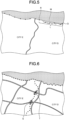
- FIG. 6 is a diagram illustrating an example of map information according to a third embodiment and is a diagram in which data on the border of an area away from a road is thinned.
- the basic configuration of the vehicle recording device 10 is the same as that of the vehicle recording device 10 of the first embodiment.
- the map information storage unit 14 is different from that of the first embodiment.
- the map information storage unit 14 stores map information that specifies the border as a set of points that are sparser than those of the place passable by a vehicle.
- the border between City D and City E is represented by black circles.
- the map information when the border of the area is off a road, the distance between adjacent points is longer than that in the case where the border of the area is on the road. The distance between two points off the road may be longer than that on the road.
- a specific distance is set according to various conditions, such as the actual shape of the border, accuracy of the map information, a resolution, a scale, a scale, a region and geographies.
- the border data on the area is specified as a set of denser points than those of places other than places passable by a vehicle.
- the border of the area is specified as a set of denser points than those of other places where the border of the area is off places that are passable by a vehicle.
- the map information when the border of the area is off places passable by a vehicle, specifies the border as a set of points sparser than those of the places passable by a vehicle.
- the border of the area when the border of the area is off places passable by a vehicle, it is possible to simplify the border of the area or make the border plain. According to the present embodiment, it is possible to further keep down the volume of the map information.
- FIG. 7 is a diagram illustrating an example of map information according to a fourth embodiment and is a diagram in which the border of an area is widened.
- FIG. 8 is a diagram illustrating the border of a normal area and the border of the area that is widened.
- FIG. 9 is a diagram illustrating another example of map information according to the fourth embodiment.
- the basic configuration of the vehicle recording device 10 is the same as that of the vehicle recording device 10 of the first embodiment.
- the map information storage unit 14 is different from that of the first embodiment.
- the map information storage unit 14 stores map information with the border of an area widened to the outside.
- the border is specified as a set of points each of which has been shifted to the outside of the area. More specifically, in the map information with the widened border of the area, latitudes and longitudes serve as the set of points shifted to the outside of the area.
- An amount of shift ⁇ d by which each point is shifted outward may be around few meters or larger or around few hundred meters or smaller.
- a specific amount of shift ⁇ d is set according to various conditions, such as the actual shape of the border, accuracy of the map information, a resolution, a scale, a scale, a region and geographies.
- the map information illustrated in FIG. 7 and FIG. 8 presents the border of the normal area by black circles and presents the border of the widened area of Country B by white circles.
- the number of points contained in the set does not change between the map information with the widened border of the area and the normal map information. Thus, even when the border of the area is widened, the volume of data of the map information does not increase.
- the area identification unit 23 may identify the area using the map information with the widened border of the area. For example, when the current position of the vehicle is positioned within a given distance from the border of the area, the area identification unit 23 may identify the area using the map information with the widened border of the area. For example, when accuracy in positioning by the position information acquisition unit 21 is low, the area identification unit 23 may identify the area using the map information with the widened border of the area.
- the border of the area may be widened dynamically based on the normal map information that is stored in the map information storage unit 14. In this case, it is unnecessary to have map information on the widened second area dually, which makes it possible to reduce the volume of data of the map information that is stored in advance.
- the map information may include information of an outline for identifying the border of the area and information associated with the information of the outline.
- the map information illustrated in FIG. 9 includes associated information on each point in addition to the map information illustrated in FIG. 2 .
- the associated information is, for example, control information containing information on whether it is necessary to widen or narrow the map in the area.
- Information on whether it is necessary to widen or narrow the map is information for indicating whether not to perform widening or narrowing with respect to points not adjacent to another area, such as those of a coastline.
- the widening or narrowing process is executed on points on which widening or narrowing in the map is "necessary", which are points as the associated information, and the widening or narrowing process is not executed on points on which widening or narrowing in the map is "not necessary”. Accordingly, it is possible to reduce computation in the process of widening or narrowing the border of the area.
- map information on the second area with the border of the area widened to the outside more than in map information on a first area that is the normal area stored in the map information storage unit 14 may be stored.
- the area identification unit 23 specifies that a spot P1 is positioned in Country A.
- the area identification unit 23 specifies that the spot P1 is positioned in Country B.
- the map information specifies the border of the area as the set of points of the border of the area widened to the outside. According to the present embodiment, widening the border of the area also makes it possible to keep down the volume of the map information that is used for the process of determining the area, etc.
- map information that a navigation system uses has a large volume of information and computation is excessive and therefore a dynamic map processing process is difficult.
- map information of the present embodiment because the volume of data of the map information is reduced more significantly than in the map information that a navigation system uses, it is possible to enable a dynamic map processing process.
- Processing the map to widen the border of the area as in the present embodiment makes it possible to, when the accuracy in measuring the current position is low, absorb an error in accuracy in the measurement. Specifically, when the accuracy in measuring the current position is low and it is positioned around the border of the area, widening the border of the area tends to lead to a determination that it is positioned in the area. Thus, for example, widening the border of an area where shooting and imaging are prohibited by law, or the like, makes it possible to avoid making a determination by mistake that it is positioned in an area where shooting and recording are permitted although it is positioned in the area where shooting and recording are prohibited. In this manner, according to the present embodiment, it is possible to reduce a probability that shooting and recording would be performed by mistake against the law and increase a probability that shooting and recording would be avoided in compliance with the law.
- the vehicle recording device 10 has been described and the vehicle recording device 10 may be carried out in various different modes in addition to the above-described embodiments.
- Each component of the vehicle recording device 10 illustrated in the drawings is functionally schematic and need not necessarily be physically configured as illustrated in the drawings.
- a specific mode of each device is not limited to those illustrated in the drawings, and all or part of the components may be functionally or physically distributed or integrated in a given unit according to the load of processing or usage of each device.
- the configuration of the vehicle recording device 10 is, for example, enabled by a program that is loaded in a memory as software.
- the configuration is described as functional blocks that are enabled by association of these sets of hardware or hardware.
- these functional blocks can be enabled in various forms using only hardware, software, or a combination of hardware and software.
- the vehicle recording device 10 has been described as an example of the vehicle electronic device; however, there is no limitation thereto.
- the vehicle electronic device may be a navigation system, an audio device, a display device, or the like.
- the vehicle electronic device includes an electronic device that is mounted on a vehicle and is used and, when a portable terminal device, such as a smartphone, is mounted on a vehicle and is used, the portable terminal device is included in the vehicle electronic device.
- the controller 20 may acquire information on the current position of the vehicle from an external navigation system.
Landscapes
- Engineering & Computer Science (AREA)
- Radar, Positioning & Navigation (AREA)
- Remote Sensing (AREA)
- Physics & Mathematics (AREA)
- General Physics & Mathematics (AREA)
- Automation & Control Theory (AREA)
- Signal Processing (AREA)
- Multimedia (AREA)
- Geometry (AREA)
- Theoretical Computer Science (AREA)
- Mathematical Physics (AREA)
- Educational Technology (AREA)
- Educational Administration (AREA)
- Business, Economics & Management (AREA)
- Life Sciences & Earth Sciences (AREA)
- Databases & Information Systems (AREA)
- Ecology (AREA)
- Navigation (AREA)
- Instructional Devices (AREA)
Claims (4)
- Dispositif électronique pour un véhicule (10) comprenant :une unité (21) pour acquérir des informations de position configurée pour acquérir des informations de position d'une position actuelle d'un véhicule ;une unité (14) pour stocker des informations de carte configurée pour stocker des informations de carte présentant une carte pour identifier une zone correspondant à la position actuelle du véhicule sur la carte ; etune unité (23) pour identifier une zone configurée pour identifier la zone correspondant à la position actuelle du véhicule sur la base des informations de position acquises par l'unité (21) pour acquérir des informations de position et des informations de carte stockées dans l'unité (14) pour stocker des informations de carte,dans lequel les informations de carte sont des informations pour identifier une frontière d'une zone contenant un pays, une préfecture, une municipalité, un état ou un district,la frontière de la zone est spécifiée comme un ensemble de points représentant la frontière, l'unité (14) pour stocker des informations de carte étant caractérisée en ce quedans les informations de carte, lorsque la frontière de la zone est hors d'un endroit qui peut être traversé par un véhicule, la frontière est spécifiée comme un ensemble de points qui est plus clairsemé que celui d'une ligne de frontière dans l'endroit qui peut être traversé par un véhicule.
- Dispositif électronique pour un véhicule (10) selon la revendication 1, dans lequel, dans les informations de carte, lorsque la frontière de la zone contient un littoral, le littoral est spécifié comme un ensemble de points qui est plus clairsemé que celui d'une ligne de frontière dans un terrain.
- Procédé de commande comprenant :une étape pour acquérir des informations de position pour acquérir des informations de position d'une position actuelle d'un véhicule ; etune étape (S101) pour identifier une zone pour identifier une zone correspondant à la position actuelle du véhicule sur la base des informations de position acquises à l'étape pour acquérir des informations de position et des informations de carte qui sont stockées dans une unité (14) pour stocker des informations de carte, les informations de carte présentant une carte pour identifier une zone correspondant à la position actuelle du véhicule sur la carte, les informations de carte étant pour identifier une frontière d'une zone contenant un pays, une préfecture, une municipalité, un état ou un district,dans lequel la frontière de la zone est spécifiée comme un ensemble de points représentant la frontière, et est caractérisée en ce quedans les informations de carte, lorsque la frontière de la zone est hors d'un endroit qui peut être traversé par un véhicule, la frontière est spécifiée comme un ensemble de points qui est plus clairsemé que celui d'une ligne de frontière dans l'endroit qui peut être traversé par un véhicule.
- Programme pour amener un ordinateur qui fonctionne comme un dispositif électronique pour un véhicule à exécuter :une étape pour acquérir des informations de position pour acquérir des informations de position d'une position actuelle d'un véhicule ; etune étape (S101) pour identifier une zone pour identifier une zone correspondant à la position actuelle du véhicule sur la base des informations de position acquises à l'étape pour acquérir des informations de position et des informations de carte qui sont stockées dans une unité (14) pour stocker des informations de carte, les informations de carte présentant une carte pour identifier une zone correspondant à la position actuelle du véhicule sur la carte, les informations de carte étant pour identifier une frontière d'une zone contenant un pays, une préfecture, une municipalité, un état ou un district,dans lequel la frontière de la zone est spécifiée comme un ensemble de points représentant la frontière, et est caractérisée en ce quedans les informations de carte, lorsque la frontière de la zone est hors d'un endroit qui peut être traversé par un véhicule, la frontière est spécifiée comme un ensemble de points qui est plus clairsemé que celui d'une ligne de frontière dans l'endroit qui peut être traversé par un véhicule.
Applications Claiming Priority (2)
| Application Number | Priority Date | Filing Date | Title |
|---|---|---|---|
| JP2019185735A JP7358896B2 (ja) | 2019-10-09 | 2019-10-09 | 車両用電子機器及び制御方法 |
| PCT/JP2020/028408 WO2021070447A1 (fr) | 2019-10-09 | 2020-07-22 | Dispositif électronique de véhicule, procédé de commande et programme |
Publications (3)
| Publication Number | Publication Date |
|---|---|
| EP4027111A1 EP4027111A1 (fr) | 2022-07-13 |
| EP4027111A4 EP4027111A4 (fr) | 2022-10-26 |
| EP4027111B1 true EP4027111B1 (fr) | 2024-06-19 |
Family
ID=75380082
Family Applications (1)
| Application Number | Title | Priority Date | Filing Date |
|---|---|---|---|
| EP20874361.7A Active EP4027111B1 (fr) | 2019-10-09 | 2020-07-22 | Dispositif électronique de véhicule, procédé de commande et programme |
Country Status (4)
| Country | Link |
|---|---|
| US (1) | US11985450B2 (fr) |
| EP (1) | EP4027111B1 (fr) |
| JP (1) | JP7358896B2 (fr) |
| WO (1) | WO2021070447A1 (fr) |
Families Citing this family (2)
| Publication number | Priority date | Publication date | Assignee | Title |
|---|---|---|---|---|
| CN113138593A (zh) * | 2020-01-02 | 2021-07-20 | 苏州宝时得电动工具有限公司 | 自主机器人的地图创建方法、装置、设备及存储介质 |
| JP2023180917A (ja) * | 2022-06-10 | 2023-12-21 | 富士通株式会社 | 出力方法および出力プログラム |
Citations (1)
| Publication number | Priority date | Publication date | Assignee | Title |
|---|---|---|---|---|
| US6308177B1 (en) * | 1996-10-25 | 2001-10-23 | Vijaya S. Israni | System and method for use and storage of geographic data on physical media |
Family Cites Families (12)
| Publication number | Priority date | Publication date | Assignee | Title |
|---|---|---|---|---|
| JP3333320B2 (ja) * | 1994-06-30 | 2002-10-15 | 松下電器産業株式会社 | 車載用地図表示装置 |
| JPH09325692A (ja) | 1996-06-06 | 1997-12-16 | Nissan Motor Co Ltd | ナビゲーション用地図表示方法 |
| DE10255329A1 (de) * | 2002-11-27 | 2004-06-09 | Robert Bosch Gmbh | Navigationssystem und Verfahren zum Betreiben eines Navigationssystems |
| JP2004226302A (ja) * | 2003-01-24 | 2004-08-12 | Denso Corp | ナビゲーション装置 |
| US20050209774A1 (en) * | 2004-03-22 | 2005-09-22 | Speedinfo | Digital map system |
| CN101903746A (zh) * | 2007-12-28 | 2010-12-01 | 电子地图有限公司 | 用于组合来自第一数字地图数据库的第一分区和来自第二数字地图数据库的第二分区的方法和设备 |
| JP2009288062A (ja) * | 2008-05-29 | 2009-12-10 | Xanavi Informatics Corp | 地図表示装置 |
| JP4905483B2 (ja) * | 2009-03-05 | 2012-03-28 | 株式会社デンソー | 地図データ更新装置および地図データ更新用プログラム |
| US8341192B2 (en) * | 2009-09-15 | 2012-12-25 | Navteq B.V. | Navigation system and methods regarding disputed territories |
| US20150095355A1 (en) * | 2012-11-15 | 2015-04-02 | Banjo, Inc. | Systems and methods for dynamic event content curation |
| US9183435B2 (en) * | 2013-12-05 | 2015-11-10 | Oracle International Corporation | Feature generalization using topological model |
| WO2018200522A1 (fr) * | 2017-04-24 | 2018-11-01 | Mobileye Vision Technologies Ltd. | Systèmes et procédés de compression de données de voies |
-
2019
- 2019-10-09 JP JP2019185735A patent/JP7358896B2/ja active Active
-
2020
- 2020-07-22 EP EP20874361.7A patent/EP4027111B1/fr active Active
- 2020-07-22 WO PCT/JP2020/028408 patent/WO2021070447A1/fr not_active Ceased
-
2022
- 2022-04-05 US US17/713,271 patent/US11985450B2/en active Active
Patent Citations (1)
| Publication number | Priority date | Publication date | Assignee | Title |
|---|---|---|---|---|
| US6308177B1 (en) * | 1996-10-25 | 2001-10-23 | Vijaya S. Israni | System and method for use and storage of geographic data on physical media |
Also Published As
| Publication number | Publication date |
|---|---|
| WO2021070447A1 (fr) | 2021-04-15 |
| JP2021060329A (ja) | 2021-04-15 |
| US20220232194A1 (en) | 2022-07-21 |
| EP4027111A4 (fr) | 2022-10-26 |
| EP4027111A1 (fr) | 2022-07-13 |
| JP7358896B2 (ja) | 2023-10-11 |
| US11985450B2 (en) | 2024-05-14 |
Similar Documents
| Publication | Publication Date | Title |
|---|---|---|
| US8258978B2 (en) | Speed limit change notification | |
| US10393852B2 (en) | Method and system of location estimation and navigation of autonomous vehicles | |
| EP1985971B1 (fr) | Dispositif pour fournir des informations sur la position d'un véhicule, son procédé, et programme informatique | |
| CN111562603B (zh) | 基于航位推算的导航定位方法、设备及存储介质 | |
| US11037442B2 (en) | System, system control method, and information providing server | |
| CN110319850B (zh) | 一种获取陀螺仪的零点偏移的方法及装置 | |
| US11985450B2 (en) | Vehicle electronic device, control method and program | |
| JPWO2009128137A1 (ja) | 情報表示装置、位置算出装置、表示制御方法、位置算出方法、表示制御プログラム、位置算出プログラムおよび記録媒体 | |
| US20070100542A1 (en) | Method for computer-based determination of a position in a map, navigation device and mobile radio telephone | |
| JP2020056740A (ja) | 位置補正システム、車載機、位置補正方法、および位置補正プログラム | |
| US10234304B2 (en) | Map information creating device, navigation system, information display method, information display program, and recording medium | |
| US10916141B1 (en) | System and method for generating a parking space directory | |
| US10704917B2 (en) | Image positioning method and image positioning device for using the same | |
| JP4312093B2 (ja) | ナビゲーション装置、ナビゲーション方法及びナビゲーションプログラム | |
| CN111354207A (zh) | 前方路况的显示方法、显示系统、存储介质及车载终端 | |
| JP2012177681A (ja) | Gps信号による移動体位置決め方法および移動体位置決定装置ならびに移動体位置決定プログラム | |
| JP2023144527A (ja) | 作業現場情報収集システム及び作業現場情報検索システム | |
| CN100565113C (zh) | 生成高度的卫星导航系统 | |
| US20220191437A1 (en) | Vehicle electronic device control device, vehicle electronic device, vehicle control method, and computer-readable storage medium | |
| US20240328817A1 (en) | Method of dynamically updating points of interest, electronic map system and cloud server device | |
| US20240200958A1 (en) | Vehicle and traveling route setting method for vehicle | |
| CN104318801A (zh) | 一种利用导航卫星信号的车辆检测方法及系统 | |
| CN115790666B (zh) | 对路内停车智能巡检车惯导定位进行校正的方法和系统 | |
| CN110736475A (zh) | 基于车载摄像装置的定位优化方法、系统、存储介质、车载终端 | |
| WO2021070538A1 (fr) | Dispositif de commande d'équipement électronique de véhicule, procédé de commande d'équipement électronique de véhicule, et programme |
Legal Events
| Date | Code | Title | Description |
|---|---|---|---|
| STAA | Information on the status of an ep patent application or granted ep patent |
Free format text: STATUS: THE INTERNATIONAL PUBLICATION HAS BEEN MADE |
|
| PUAI | Public reference made under article 153(3) epc to a published international application that has entered the european phase |
Free format text: ORIGINAL CODE: 0009012 |
|
| STAA | Information on the status of an ep patent application or granted ep patent |
Free format text: STATUS: REQUEST FOR EXAMINATION WAS MADE |
|
| 17P | Request for examination filed |
Effective date: 20220404 |
|
| AK | Designated contracting states |
Kind code of ref document: A1 Designated state(s): AL AT BE BG CH CY CZ DE DK EE ES FI FR GB GR HR HU IE IS IT LI LT LU LV MC MK MT NL NO PL PT RO RS SE SI SK SM TR |
|
| A4 | Supplementary search report drawn up and despatched |
Effective date: 20220922 |
|
| RIC1 | Information provided on ipc code assigned before grant |
Ipc: G01C 21/00 20060101ALI20220916BHEP Ipc: G01C 21/26 20060101AFI20220916BHEP |
|
| DAV | Request for validation of the european patent (deleted) | ||
| DAX | Request for extension of the european patent (deleted) | ||
| STAA | Information on the status of an ep patent application or granted ep patent |
Free format text: STATUS: EXAMINATION IS IN PROGRESS |
|
| 17Q | First examination report despatched |
Effective date: 20230601 |
|
| REG | Reference to a national code |
Ref country code: DE Free format text: PREVIOUS MAIN CLASS: G01C0021260000 Ref country code: DE Ref legal event code: R079 Ref document number: 602020032779 Country of ref document: DE Free format text: PREVIOUS MAIN CLASS: G01C0021260000 Ipc: G01C0021000000 |
|
| GRAP | Despatch of communication of intention to grant a patent |
Free format text: ORIGINAL CODE: EPIDOSNIGR1 |
|
| RIC1 | Information provided on ipc code assigned before grant |
Ipc: G01C 21/00 20060101AFI20231218BHEP |
|
| STAA | Information on the status of an ep patent application or granted ep patent |
Free format text: STATUS: GRANT OF PATENT IS INTENDED |
|
| INTG | Intention to grant announced |
Effective date: 20240125 |
|
| GRAS | Grant fee paid |
Free format text: ORIGINAL CODE: EPIDOSNIGR3 |
|
| GRAA | (expected) grant |
Free format text: ORIGINAL CODE: 0009210 |
|
| STAA | Information on the status of an ep patent application or granted ep patent |
Free format text: STATUS: THE PATENT HAS BEEN GRANTED |
|
| AK | Designated contracting states |
Kind code of ref document: B1 Designated state(s): AL AT BE BG CH CY CZ DE DK EE ES FI FR GB GR HR HU IE IS IT LI LT LU LV MC MK MT NL NO PL PT RO RS SE SI SK SM TR |
|
| REG | Reference to a national code |
Ref country code: GB Ref legal event code: FG4D |
|
| REG | Reference to a national code |
Ref country code: CH Ref legal event code: EP |
|
| REG | Reference to a national code |
Ref country code: DE Ref legal event code: R096 Ref document number: 602020032779 Country of ref document: DE |
|
| PG25 | Lapsed in a contracting state [announced via postgrant information from national office to epo] |
Ref country code: BG Free format text: LAPSE BECAUSE OF FAILURE TO SUBMIT A TRANSLATION OF THE DESCRIPTION OR TO PAY THE FEE WITHIN THE PRESCRIBED TIME-LIMIT Effective date: 20240619 |
|
| PG25 | Lapsed in a contracting state [announced via postgrant information from national office to epo] |
Ref country code: HR Free format text: LAPSE BECAUSE OF FAILURE TO SUBMIT A TRANSLATION OF THE DESCRIPTION OR TO PAY THE FEE WITHIN THE PRESCRIBED TIME-LIMIT Effective date: 20240619 Ref country code: FI Free format text: LAPSE BECAUSE OF FAILURE TO SUBMIT A TRANSLATION OF THE DESCRIPTION OR TO PAY THE FEE WITHIN THE PRESCRIBED TIME-LIMIT Effective date: 20240619 |
|
| REG | Reference to a national code |
Ref country code: LT Ref legal event code: MG9D |
|
| PG25 | Lapsed in a contracting state [announced via postgrant information from national office to epo] |
Ref country code: GR Free format text: LAPSE BECAUSE OF FAILURE TO SUBMIT A TRANSLATION OF THE DESCRIPTION OR TO PAY THE FEE WITHIN THE PRESCRIBED TIME-LIMIT Effective date: 20240920 |
|
| REG | Reference to a national code |
Ref country code: NL Ref legal event code: MP Effective date: 20240619 |
|
| PG25 | Lapsed in a contracting state [announced via postgrant information from national office to epo] |
Ref country code: LV Free format text: LAPSE BECAUSE OF FAILURE TO SUBMIT A TRANSLATION OF THE DESCRIPTION OR TO PAY THE FEE WITHIN THE PRESCRIBED TIME-LIMIT Effective date: 20240619 |
|
| PG25 | Lapsed in a contracting state [announced via postgrant information from national office to epo] |
Ref country code: NO Free format text: LAPSE BECAUSE OF FAILURE TO SUBMIT A TRANSLATION OF THE DESCRIPTION OR TO PAY THE FEE WITHIN THE PRESCRIBED TIME-LIMIT Effective date: 20240919 Ref country code: LV Free format text: LAPSE BECAUSE OF FAILURE TO SUBMIT A TRANSLATION OF THE DESCRIPTION OR TO PAY THE FEE WITHIN THE PRESCRIBED TIME-LIMIT Effective date: 20240619 Ref country code: HR Free format text: LAPSE BECAUSE OF FAILURE TO SUBMIT A TRANSLATION OF THE DESCRIPTION OR TO PAY THE FEE WITHIN THE PRESCRIBED TIME-LIMIT Effective date: 20240619 Ref country code: GR Free format text: LAPSE BECAUSE OF FAILURE TO SUBMIT A TRANSLATION OF THE DESCRIPTION OR TO PAY THE FEE WITHIN THE PRESCRIBED TIME-LIMIT Effective date: 20240920 Ref country code: FI Free format text: LAPSE BECAUSE OF FAILURE TO SUBMIT A TRANSLATION OF THE DESCRIPTION OR TO PAY THE FEE WITHIN THE PRESCRIBED TIME-LIMIT Effective date: 20240619 Ref country code: BG Free format text: LAPSE BECAUSE OF FAILURE TO SUBMIT A TRANSLATION OF THE DESCRIPTION OR TO PAY THE FEE WITHIN THE PRESCRIBED TIME-LIMIT Effective date: 20240619 Ref country code: RS Free format text: LAPSE BECAUSE OF FAILURE TO SUBMIT A TRANSLATION OF THE DESCRIPTION OR TO PAY THE FEE WITHIN THE PRESCRIBED TIME-LIMIT Effective date: 20240919 |
|
| PG25 | Lapsed in a contracting state [announced via postgrant information from national office to epo] |
Ref country code: NL Free format text: LAPSE BECAUSE OF FAILURE TO SUBMIT A TRANSLATION OF THE DESCRIPTION OR TO PAY THE FEE WITHIN THE PRESCRIBED TIME-LIMIT Effective date: 20240619 |
|
| REG | Reference to a national code |
Ref country code: AT Ref legal event code: MK05 Ref document number: 1696171 Country of ref document: AT Kind code of ref document: T Effective date: 20240619 |
|
| PG25 | Lapsed in a contracting state [announced via postgrant information from national office to epo] |
Ref country code: NL Free format text: LAPSE BECAUSE OF FAILURE TO SUBMIT A TRANSLATION OF THE DESCRIPTION OR TO PAY THE FEE WITHIN THE PRESCRIBED TIME-LIMIT Effective date: 20240619 |
|
| PG25 | Lapsed in a contracting state [announced via postgrant information from national office to epo] |
Ref country code: PT Free format text: LAPSE BECAUSE OF FAILURE TO SUBMIT A TRANSLATION OF THE DESCRIPTION OR TO PAY THE FEE WITHIN THE PRESCRIBED TIME-LIMIT Effective date: 20241021 |
|
| PG25 | Lapsed in a contracting state [announced via postgrant information from national office to epo] |
Ref country code: PT Free format text: LAPSE BECAUSE OF FAILURE TO SUBMIT A TRANSLATION OF THE DESCRIPTION OR TO PAY THE FEE WITHIN THE PRESCRIBED TIME-LIMIT Effective date: 20241021 |
|
| PG25 | Lapsed in a contracting state [announced via postgrant information from national office to epo] |
Ref country code: PL Free format text: LAPSE BECAUSE OF FAILURE TO SUBMIT A TRANSLATION OF THE DESCRIPTION OR TO PAY THE FEE WITHIN THE PRESCRIBED TIME-LIMIT Effective date: 20240619 |
|
| PG25 | Lapsed in a contracting state [announced via postgrant information from national office to epo] |
Ref country code: EE Free format text: LAPSE BECAUSE OF FAILURE TO SUBMIT A TRANSLATION OF THE DESCRIPTION OR TO PAY THE FEE WITHIN THE PRESCRIBED TIME-LIMIT Effective date: 20240619 |
|
| PG25 | Lapsed in a contracting state [announced via postgrant information from national office to epo] |
Ref country code: AT Free format text: LAPSE BECAUSE OF FAILURE TO SUBMIT A TRANSLATION OF THE DESCRIPTION OR TO PAY THE FEE WITHIN THE PRESCRIBED TIME-LIMIT Effective date: 20240619 Ref country code: IS Free format text: LAPSE BECAUSE OF FAILURE TO SUBMIT A TRANSLATION OF THE DESCRIPTION OR TO PAY THE FEE WITHIN THE PRESCRIBED TIME-LIMIT Effective date: 20241019 |
|
| PG25 | Lapsed in a contracting state [announced via postgrant information from national office to epo] |
Ref country code: CZ Free format text: LAPSE BECAUSE OF FAILURE TO SUBMIT A TRANSLATION OF THE DESCRIPTION OR TO PAY THE FEE WITHIN THE PRESCRIBED TIME-LIMIT Effective date: 20240619 |
|
| PG25 | Lapsed in a contracting state [announced via postgrant information from national office to epo] |
Ref country code: RO Free format text: LAPSE BECAUSE OF FAILURE TO SUBMIT A TRANSLATION OF THE DESCRIPTION OR TO PAY THE FEE WITHIN THE PRESCRIBED TIME-LIMIT Effective date: 20240619 Ref country code: SK Free format text: LAPSE BECAUSE OF FAILURE TO SUBMIT A TRANSLATION OF THE DESCRIPTION OR TO PAY THE FEE WITHIN THE PRESCRIBED TIME-LIMIT Effective date: 20240619 |
|
| PG25 | Lapsed in a contracting state [announced via postgrant information from national office to epo] |
Ref country code: ES Free format text: LAPSE BECAUSE OF FAILURE TO SUBMIT A TRANSLATION OF THE DESCRIPTION OR TO PAY THE FEE WITHIN THE PRESCRIBED TIME-LIMIT Effective date: 20240619 Ref country code: SM Free format text: LAPSE BECAUSE OF FAILURE TO SUBMIT A TRANSLATION OF THE DESCRIPTION OR TO PAY THE FEE WITHIN THE PRESCRIBED TIME-LIMIT Effective date: 20240619 |
|
| PG25 | Lapsed in a contracting state [announced via postgrant information from national office to epo] |
Ref country code: SM Free format text: LAPSE BECAUSE OF FAILURE TO SUBMIT A TRANSLATION OF THE DESCRIPTION OR TO PAY THE FEE WITHIN THE PRESCRIBED TIME-LIMIT Effective date: 20240619 Ref country code: SK Free format text: LAPSE BECAUSE OF FAILURE TO SUBMIT A TRANSLATION OF THE DESCRIPTION OR TO PAY THE FEE WITHIN THE PRESCRIBED TIME-LIMIT Effective date: 20240619 Ref country code: RO Free format text: LAPSE BECAUSE OF FAILURE TO SUBMIT A TRANSLATION OF THE DESCRIPTION OR TO PAY THE FEE WITHIN THE PRESCRIBED TIME-LIMIT Effective date: 20240619 Ref country code: PL Free format text: LAPSE BECAUSE OF FAILURE TO SUBMIT A TRANSLATION OF THE DESCRIPTION OR TO PAY THE FEE WITHIN THE PRESCRIBED TIME-LIMIT Effective date: 20240619 Ref country code: IS Free format text: LAPSE BECAUSE OF FAILURE TO SUBMIT A TRANSLATION OF THE DESCRIPTION OR TO PAY THE FEE WITHIN THE PRESCRIBED TIME-LIMIT Effective date: 20241019 Ref country code: ES Free format text: LAPSE BECAUSE OF FAILURE TO SUBMIT A TRANSLATION OF THE DESCRIPTION OR TO PAY THE FEE WITHIN THE PRESCRIBED TIME-LIMIT Effective date: 20240619 Ref country code: EE Free format text: LAPSE BECAUSE OF FAILURE TO SUBMIT A TRANSLATION OF THE DESCRIPTION OR TO PAY THE FEE WITHIN THE PRESCRIBED TIME-LIMIT Effective date: 20240619 Ref country code: CZ Free format text: LAPSE BECAUSE OF FAILURE TO SUBMIT A TRANSLATION OF THE DESCRIPTION OR TO PAY THE FEE WITHIN THE PRESCRIBED TIME-LIMIT Effective date: 20240619 Ref country code: AT Free format text: LAPSE BECAUSE OF FAILURE TO SUBMIT A TRANSLATION OF THE DESCRIPTION OR TO PAY THE FEE WITHIN THE PRESCRIBED TIME-LIMIT Effective date: 20240619 |
|
| PG25 | Lapsed in a contracting state [announced via postgrant information from national office to epo] |
Ref country code: IT Free format text: LAPSE BECAUSE OF FAILURE TO SUBMIT A TRANSLATION OF THE DESCRIPTION OR TO PAY THE FEE WITHIN THE PRESCRIBED TIME-LIMIT Effective date: 20240619 |
|
| REG | Reference to a national code |
Ref country code: CH Ref legal event code: PL |
|
| PG25 | Lapsed in a contracting state [announced via postgrant information from national office to epo] |
Ref country code: LU Free format text: LAPSE BECAUSE OF NON-PAYMENT OF DUE FEES Effective date: 20240722 |
|
| PG25 | Lapsed in a contracting state [announced via postgrant information from national office to epo] |
Ref country code: MC Free format text: LAPSE BECAUSE OF FAILURE TO SUBMIT A TRANSLATION OF THE DESCRIPTION OR TO PAY THE FEE WITHIN THE PRESCRIBED TIME-LIMIT Effective date: 20240619 |
|
| REG | Reference to a national code |
Ref country code: DE Ref legal event code: R097 Ref document number: 602020032779 Country of ref document: DE |
|
| PG25 | Lapsed in a contracting state [announced via postgrant information from national office to epo] |
Ref country code: MC Free format text: LAPSE BECAUSE OF FAILURE TO SUBMIT A TRANSLATION OF THE DESCRIPTION OR TO PAY THE FEE WITHIN THE PRESCRIBED TIME-LIMIT Effective date: 20240619 Ref country code: LU Free format text: LAPSE BECAUSE OF NON-PAYMENT OF DUE FEES Effective date: 20240722 |
|
| PG25 | Lapsed in a contracting state [announced via postgrant information from national office to epo] |
Ref country code: DK Free format text: LAPSE BECAUSE OF FAILURE TO SUBMIT A TRANSLATION OF THE DESCRIPTION OR TO PAY THE FEE WITHIN THE PRESCRIBED TIME-LIMIT Effective date: 20240619 |
|
| PG25 | Lapsed in a contracting state [announced via postgrant information from national office to epo] |
Ref country code: BE Free format text: LAPSE BECAUSE OF NON-PAYMENT OF DUE FEES Effective date: 20240731 Ref country code: CH Free format text: LAPSE BECAUSE OF NON-PAYMENT OF DUE FEES Effective date: 20240731 |
|
| PLBE | No opposition filed within time limit |
Free format text: ORIGINAL CODE: 0009261 |
|
| STAA | Information on the status of an ep patent application or granted ep patent |
Free format text: STATUS: NO OPPOSITION FILED WITHIN TIME LIMIT |
|
| 26N | No opposition filed |
Effective date: 20250320 |
|
| GBPC | Gb: european patent ceased through non-payment of renewal fee |
Effective date: 20240919 |
|
| REG | Reference to a national code |
Ref country code: BE Ref legal event code: MM Effective date: 20240731 |
|
| PG25 | Lapsed in a contracting state [announced via postgrant information from national office to epo] |
Ref country code: GB Free format text: LAPSE BECAUSE OF NON-PAYMENT OF DUE FEES Effective date: 20240919 |
|
| PG25 | Lapsed in a contracting state [announced via postgrant information from national office to epo] |
Ref country code: FR Free format text: LAPSE BECAUSE OF NON-PAYMENT OF DUE FEES Effective date: 20240819 |
|
| PG25 | Lapsed in a contracting state [announced via postgrant information from national office to epo] |
Ref country code: IE Free format text: LAPSE BECAUSE OF NON-PAYMENT OF DUE FEES Effective date: 20240722 |
|
| PG25 | Lapsed in a contracting state [announced via postgrant information from national office to epo] |
Ref country code: SE Free format text: LAPSE BECAUSE OF FAILURE TO SUBMIT A TRANSLATION OF THE DESCRIPTION OR TO PAY THE FEE WITHIN THE PRESCRIBED TIME-LIMIT Effective date: 20240619 |
|
| PGFP | Annual fee paid to national office [announced via postgrant information from national office to epo] |
Ref country code: DE Payment date: 20250528 Year of fee payment: 6 |
|
| PG25 | Lapsed in a contracting state [announced via postgrant information from national office to epo] |
Ref country code: CY Free format text: LAPSE BECAUSE OF FAILURE TO SUBMIT A TRANSLATION OF THE DESCRIPTION OR TO PAY THE FEE WITHIN THE PRESCRIBED TIME-LIMIT; INVALID AB INITIO Effective date: 20200722 |
|
| PG25 | Lapsed in a contracting state [announced via postgrant information from national office to epo] |
Ref country code: HU Free format text: LAPSE BECAUSE OF FAILURE TO SUBMIT A TRANSLATION OF THE DESCRIPTION OR TO PAY THE FEE WITHIN THE PRESCRIBED TIME-LIMIT; INVALID AB INITIO Effective date: 20200722 |