EP4239428A2 - Procédé et système de navigation d'un chariot de manutention - Google Patents
Procédé et système de navigation d'un chariot de manutention Download PDFInfo
- Publication number
- EP4239428A2 EP4239428A2 EP22203506.5A EP22203506A EP4239428A2 EP 4239428 A2 EP4239428 A2 EP 4239428A2 EP 22203506 A EP22203506 A EP 22203506A EP 4239428 A2 EP4239428 A2 EP 4239428A2
- Authority
- EP
- European Patent Office
- Prior art keywords
- coordinate system
- industrial truck
- map
- processing device
- data processing
- Prior art date
- Legal status (The legal status is an assumption and is not a legal conclusion. Google has not performed a legal analysis and makes no representation as to the accuracy of the status listed.)
- Granted
Links
Images
Classifications
-
- G—PHYSICS
- G05—CONTROLLING; REGULATING
- G05D—SYSTEMS FOR CONTROLLING OR REGULATING NON-ELECTRIC VARIABLES
- G05D1/00—Control of position, course, altitude or attitude of land, water, air or space vehicles, e.g. using automatic pilots
- G05D1/02—Control of position or course in two dimensions
- G05D1/021—Control of position or course in two dimensions specially adapted to land vehicles
- G05D1/0268—Control of position or course in two dimensions specially adapted to land vehicles using internal positioning means
- G05D1/0274—Control of position or course in two dimensions specially adapted to land vehicles using internal positioning means using mapping information stored in a memory device
-
- B—PERFORMING OPERATIONS; TRANSPORTING
- B66—HOISTING; LIFTING; HAULING
- B66F—HOISTING, LIFTING, HAULING OR PUSHING, NOT OTHERWISE PROVIDED FOR, e.g. DEVICES WHICH APPLY A LIFTING OR PUSHING FORCE DIRECTLY TO THE SURFACE OF A LOAD
- B66F9/00—Devices for lifting or lowering bulky or heavy goods for loading or unloading purposes
- B66F9/06—Devices for lifting or lowering bulky or heavy goods for loading or unloading purposes movable, with their loads, on wheels or the like, e.g. fork-lift trucks
- B66F9/063—Automatically guided
-
- B—PERFORMING OPERATIONS; TRANSPORTING
- B66—HOISTING; LIFTING; HAULING
- B66F—HOISTING, LIFTING, HAULING OR PUSHING, NOT OTHERWISE PROVIDED FOR, e.g. DEVICES WHICH APPLY A LIFTING OR PUSHING FORCE DIRECTLY TO THE SURFACE OF A LOAD
- B66F9/00—Devices for lifting or lowering bulky or heavy goods for loading or unloading purposes
- B66F9/06—Devices for lifting or lowering bulky or heavy goods for loading or unloading purposes movable, with their loads, on wheels or the like, e.g. fork-lift trucks
- B66F9/075—Constructional features or details
- B66F9/0755—Position control; Position detectors
-
- G—PHYSICS
- G01—MEASURING; TESTING
- G01C—MEASURING DISTANCES, LEVELS OR BEARINGS; SURVEYING; NAVIGATION; GYROSCOPIC INSTRUMENTS; PHOTOGRAMMETRY OR VIDEOGRAMMETRY
- G01C21/00—Navigation; Navigational instruments not provided for in groups G01C1/00 - G01C19/00
- G01C21/005—Navigation; Navigational instruments not provided for in groups G01C1/00 - G01C19/00 with correlation of navigation data from several sources, e.g. map or contour matching
-
- G—PHYSICS
- G01—MEASURING; TESTING
- G01C—MEASURING DISTANCES, LEVELS OR BEARINGS; SURVEYING; NAVIGATION; GYROSCOPIC INSTRUMENTS; PHOTOGRAMMETRY OR VIDEOGRAMMETRY
- G01C21/00—Navigation; Navigational instruments not provided for in groups G01C1/00 - G01C19/00
- G01C21/20—Instruments for performing navigational calculations
- G01C21/206—Instruments for performing navigational calculations specially adapted for indoor navigation
-
- G—PHYSICS
- G05—CONTROLLING; REGULATING
- G05D—SYSTEMS FOR CONTROLLING OR REGULATING NON-ELECTRIC VARIABLES
- G05D1/00—Control of position, course, altitude or attitude of land, water, air or space vehicles, e.g. using automatic pilots
- G05D1/02—Control of position or course in two dimensions
- G05D1/021—Control of position or course in two dimensions specially adapted to land vehicles
- G05D1/0231—Control of position or course in two dimensions specially adapted to land vehicles using optical position detecting means
- G05D1/0234—Control of position or course in two dimensions specially adapted to land vehicles using optical position detecting means using optical markers or beacons
Definitions
- the invention relates to a method for navigating an industrial truck, in particular an autonomous or automated industrial truck, with a sensor system for detecting information in the operating area of the industrial truck and a data processing device for evaluating this information and creating navigation instructions and/or control commands for navigating the industrial truck, with the starting point from a reconnaissance trip, a map of the surroundings is first created in the data processing device in a vehicle coordinate system with the help of the sensors and during a subsequent navigation trip, a scene currently recorded by the sensors is compared in the data processing device with the map of the surroundings and the industrial truck is localized in the vehicle coordinate system.
- the invention also relates to a system for carrying out the method.
- navigation systems are increasingly being used, which are intended to enable automated or partially automated operation of an industrial truck.
- industrial trucks are mostly used in defined operating areas, for example in warehouses, location-based navigation systems can be used for this.
- signs, lines and signs or also barcodes and radio stations for the transmission of identification signals (radio beacons) are attached in the warehouse.
- radio beacons radio beacons
- this information can only be called up if it is entered into a management system for operating the industrial truck.
- the industrial truck can use a sensor, for example an optical sensor, to record this information and use a data processing device to compare it with the entries in the management system. In this way, easier manual or automatic navigation of the industrial truck in the warehouse is possible.
- SLAM Simultaneous Localization and Mapping
- the SLAM method started with laser sensors and was then expanded over the years to include other sensors, such as 2D and 3D cameras, inertial measurement units (IMUs), ultrasonic sensors, etc.
- sensors such as 2D and 3D cameras, inertial measurement units (IMUs), ultrasonic sensors, etc.
- MVSLAM Multi-Vehicle-SLAM
- the present invention is based on the object of designing a method of the type mentioned and a system for carrying out the method in such a way that improved localization of the industrial truck is made possible.
- this object is achieved according to the invention in that at least one marking with a known global position in the operating area of the industrial truck is detected by the sensor system, and a reference coordinate system is defined by evaluating the sensor data in the data processing device, and the map of the surroundings created in the vehicle coordinate system is compared in the data processing device with the Reference coordinate system is compared, and the localization of the truck in the vehicle coordinate system in the data processing device is converted into a localization of the truck in the reference coordinate system.
- the invention is based on the idea that by defining a reference coordinate system, a relationship can be established between the map of the surroundings recorded using the SLAM method or another mapping method using the sensors of the industrial truck and the actual operating environment of the autonomous or automated industrial truck. This creates an understanding of the autonomous or automated industrial truck about where it is in the environment map it has created and in the global work environment. At the same time, this makes it possible to compare maps of the surroundings of different industrial trucks.
- a marking is used whose three-dimensional pose, in particular its translational position in the three spatial axes x, y and z and its spatial orientation through solid angle rotations about the three spatial axes, is known.
- a single mark is sufficient to define a reference coordinate system.
- a preferred development of the invention provides that at least two markings are used whose translatory positions in the three spatial axes x, y and z are known.
- a clear assignment is important. If there are several of these natural markings with a similar arrangement in space, these are not suitable as natural markings.
- an artificial marking in particular a reflector, a QR code or an Aruco marker, can also be used as a marking.
- Such artificial markings can also increase the uniqueness, since they do not occur naturally in the environment.
- mapping method for example based on the SLAM method, is informed of which marking the reference coordinate system is placed on and how this relates to the marking.
- the map of the surroundings is displayed by a display device, for example a display installed on the industrial truck or a smartphone, and an operator can interactively set the reference coordinate system on the display device.
- a display device for example a display installed on the industrial truck or a smartphone, and an operator can interactively set the reference coordinate system on the display device.
- the object is also achieved by a method for creating a map with a sensor system for detecting information in the operating area of an industrial truck, based on a reconnaissance trip, a map of the surroundings is first created in a data processing device in a vehicle coordinate system with the aid of sensors, and the map of the surroundings is compared with a reference coordinate system of the operating area by comparing the map of the surroundings with a CAD map of the operating area.
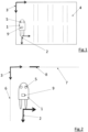
- the markings 6 and 7 are wall surfaces of a warehouse, the global positions of which are known in the reference coordinate system 3 and which are detected by the sensors 5 of the industrial truck 1 .
- the marking 8 is a sign, for example an emergency exit sign, which is set up at a known global position of the reference coordinate system 3 and is also detected by the sensor system 5 .
- the reference coordinate system 3 is determined by evaluating the sensor data in the data processing device 9 of the industrial truck 1 .
- the vehicle coordinate system 2 is compared with the reference coordinate system 3 so that the global localization of the industrial truck 1 in the working environment is made possible in the data processing device 9 .
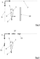
- the figure 3 shows an alternative representation of natural markings 6, 7, 10 for determining reference coordinates.
- the markings 6 and 7 are in turn wall surfaces of a warehouse, the global positions of which are known in the reference coordinate system 3 and which are detected by the sensors 5 of the industrial truck 1 .
- a shelf or shelf supports of a shelf is used as a marking 10 , the global position of which in the warehouse 4 and thus in the reference coordinate system 3 is also known and which is detected by the sensor system 5 of the industrial truck 1 .
- the arrangement corresponds to figure 3 the figure 2 .
- the marks 11, 12, 13 included QR codes, which can be read by the sensor system 5 of the industrial truck 1, which is in particular designed as a camera.
- the QR codes contain information about the global positions of the markings 11, 12, 13 in the reference coordinate system 3.
- the markings 11, 12, 13 and their information about the global positions in the reference coordinate system 3 are recorded by the sensors 5 of the industrial truck 1.
Landscapes
- Engineering & Computer Science (AREA)
- Radar, Positioning & Navigation (AREA)
- Remote Sensing (AREA)
- Physics & Mathematics (AREA)
- Structural Engineering (AREA)
- General Physics & Mathematics (AREA)
- Transportation (AREA)
- Automation & Control Theory (AREA)
- Civil Engineering (AREA)
- Life Sciences & Earth Sciences (AREA)
- Geology (AREA)
- Mechanical Engineering (AREA)
- Aviation & Aerospace Engineering (AREA)
- Electromagnetism (AREA)
- Control Of Position, Course, Altitude, Or Attitude Of Moving Bodies (AREA)
- Forklifts And Lifting Vehicles (AREA)
Priority Applications (1)
| Application Number | Priority Date | Filing Date | Title |
|---|---|---|---|
| EP25224905.7A EP4697116A3 (fr) | 2021-11-23 | 2022-10-25 | Procédé et système de navigation d'un chariot de manutention |
Applications Claiming Priority (1)
| Application Number | Priority Date | Filing Date | Title |
|---|---|---|---|
| DE102021130631.0A DE102021130631A1 (de) | 2021-11-23 | 2021-11-23 | Verfahren und System zur Navigation eines Flurförderzeugs |
Related Child Applications (2)
| Application Number | Title | Priority Date | Filing Date |
|---|---|---|---|
| EP25224905.7A Division-Into EP4697116A3 (fr) | 2021-11-23 | 2022-10-25 | Procédé et système de navigation d'un chariot de manutention |
| EP25224905.7A Division EP4697116A3 (fr) | 2021-11-23 | 2022-10-25 | Procédé et système de navigation d'un chariot de manutention |
Publications (4)
| Publication Number | Publication Date |
|---|---|
| EP4239428A2 true EP4239428A2 (fr) | 2023-09-06 |
| EP4239428A3 EP4239428A3 (fr) | 2024-01-24 |
| EP4239428B1 EP4239428B1 (fr) | 2026-01-28 |
| EP4239428C0 EP4239428C0 (fr) | 2026-01-28 |
Family
ID=83996422
Family Applications (2)
| Application Number | Title | Priority Date | Filing Date |
|---|---|---|---|
| EP25224905.7A Pending EP4697116A3 (fr) | 2021-11-23 | 2022-10-25 | Procédé et système de navigation d'un chariot de manutention |
| EP22203506.5A Active EP4239428B1 (fr) | 2021-11-23 | 2022-10-25 | Procédé et système de navigation d'un chariot de manutention |
Family Applications Before (1)
| Application Number | Title | Priority Date | Filing Date |
|---|---|---|---|
| EP25224905.7A Pending EP4697116A3 (fr) | 2021-11-23 | 2022-10-25 | Procédé et système de navigation d'un chariot de manutention |
Country Status (2)
| Country | Link |
|---|---|
| EP (2) | EP4697116A3 (fr) |
| DE (1) | DE102021130631A1 (fr) |
Families Citing this family (2)
| Publication number | Priority date | Publication date | Assignee | Title |
|---|---|---|---|---|
| DE102023206407A1 (de) * | 2023-07-06 | 2025-01-09 | Continental Autonomous Mobility Germany GmbH | Verfahren zur automatischen Lokalisierung eines Ego-Fahrzeugs mittels zumindest eines Registrierungsmusters für einen oder mehrere Umfelderfassungssensoren |
| EP4498040B1 (fr) * | 2023-07-25 | 2026-04-08 | Jungheinrich Aktiengesellschaft | Procédé et dispositif de production d'une carte de localisation et de mise à jour de ladite carte de localisation |
Family Cites Families (4)
| Publication number | Priority date | Publication date | Assignee | Title |
|---|---|---|---|---|
| KR20120108277A (ko) * | 2011-03-23 | 2012-10-05 | (주)하기소닉 | 자연랜드마크와 인공랜드마크를 인식하는 지능형 이동로봇의 위치인식 방법 |
| JP7139762B2 (ja) * | 2018-07-31 | 2022-09-21 | カシオ計算機株式会社 | 自律移動装置、自律移動方法及びプログラム |
| JP7482453B2 (ja) * | 2018-12-28 | 2024-05-14 | パナソニックIpマネジメント株式会社 | 測位装置及び移動体 |
| DE102019217160A1 (de) * | 2019-11-07 | 2021-05-12 | Robert Bosch Gmbh | Computer-implementiertes Verfahren zum Erstellen einer Umgebungskarte für das Betreiben eines mobilen Agenten |
-
2021
- 2021-11-23 DE DE102021130631.0A patent/DE102021130631A1/de active Pending
-
2022
- 2022-10-25 EP EP25224905.7A patent/EP4697116A3/fr active Pending
- 2022-10-25 EP EP22203506.5A patent/EP4239428B1/fr active Active
Non-Patent Citations (3)
| Title |
|---|
| D. MORATUWAGEB. VOD. WANG: "A hierarchical approach to the Multi-Vehicle-SLAM-Problem", 15 TH INTERNATIONAL CONFERENCE ON INFORMATION FUSION, SINGAPORE, 2012, pages 1119 - 1125, XP032228543 |
| D. MORATUWAGEB. VOD. WANG: "Collaborative multi-vehicle SLAM with moving object tracking", 2013 IEEE INTERNATIONAL CONFERENCE ON ROBOTICS AND AUTOMATION, KARLSRUHE, 2013, pages 5702 - 5708, XP032506717, DOI: 10.1109/ICRA.2013.6631397 |
| F. ZHANGH. STÄHLEG. CHENC. BUCKLA. KNOLL: "Multiple vehicle cooperative localization under random finite set framework", 2013 IEEE/RSJ INTERNATIONAL CONFERENCE ON INTELLIGENT ROBOTS AND SYSTEMS, TOKYO, 2013, pages 1405 - 1411, XP032537661, DOI: 10.1109/IROS.2013.6696533 |
Also Published As
| Publication number | Publication date |
|---|---|
| EP4239428B1 (fr) | 2026-01-28 |
| EP4697116A2 (fr) | 2026-02-18 |
| EP4239428A3 (fr) | 2024-01-24 |
| EP4239428C0 (fr) | 2026-01-28 |
| DE102021130631A1 (de) | 2023-05-25 |
| EP4697116A3 (fr) | 2026-02-25 |
Similar Documents
| Publication | Publication Date | Title |
|---|---|---|
| EP3105547B1 (fr) | Procédé de détermination de la position absolue d'une unité mobile et unité mobile | |
| EP2568310A2 (fr) | Procédé, système et dispositif de localisation d'un véhicule par rapport à un système de référence prédéfini | |
| EP4239428B1 (fr) | Procédé et système de navigation d'un chariot de manutention | |
| EP2824525A1 (fr) | Procédé et dispositif de détermination de la position de moyens de fonctionnement d'une installation d'automatisation industrielle | |
| WO2003096052A2 (fr) | Dispositif de localisation au moyen de points de repere fixes et/ou variables | |
| EP4186651B1 (fr) | Système et procédé doté d'un système | |
| WO2020126240A1 (fr) | Procédé pour faire fonctionner un appareil de terrain de la technique d'automatisation dans un environnement de réalité augmentée/de réalité mixte | |
| WO2020239491A1 (fr) | Procédé de fabrication d'une carte d'environnement pour l'utilisation lors de la navigation autonome d'un robot mobile | |
| EP4457572A1 (fr) | Procédé et système de navigation de robots logistiques mobiles | |
| DE102019202733B4 (de) | Steuergerät zur Navigation eines autonomen Fahrzeugs | |
| DE102021126879A1 (de) | Dezentralisierte standortbestimmungssysteme und -verfahren | |
| EP3454158B1 (fr) | Procédé et dispositif de navigation d'un chariot de manutention | |
| EP3809228B1 (fr) | Procédé de navigation d'un chariot de manutention | |
| DE102019203484A1 (de) | Verfahren, Vorrichtung und System zur Navigation autonomer Fahrzeuge | |
| WO2010006352A1 (fr) | Procédé et dispositif pour détecter la position d’un véhicule dans une zone définie | |
| DE102016222664A1 (de) | Verfahren zur Installation eines Lokalisierungssystems | |
| EP4004491B1 (fr) | Procédé de localisation d'un véhicule | |
| DE102020213111A1 (de) | Verfahren und System zur Bestimmung einer Pose oder Position eines mobilen Endgeräts | |
| DE102017220634B4 (de) | Anordnung und Verfahren | |
| DE102022207370A1 (de) | Verfahren zum Erkennen einer fehlerhaften Karte einer Umgebung | |
| DE102016222156A1 (de) | Verfahren und Steuereinheit zur Steuerung eines autonomen Transportfahrzeugs | |
| DE102016116855A1 (de) | System und Verfahren zum Steuern von Nutzfahrzeugen | |
| DE102019220364A1 (de) | Kalibriereinrichtung und Verfahren zum Kalibrieren einer Vorrichtung | |
| AT527919B1 (de) | Verfahren zur organisation von gütern in einem logistik-bereich | |
| DE102019216668A1 (de) | Verfahren und Vorrichtung zum Steuern einer Bewegung einer Hebevorrichtung und Hebevorrichtung |
Legal Events
| Date | Code | Title | Description |
|---|---|---|---|
| PUAI | Public reference made under article 153(3) epc to a published international application that has entered the european phase |
Free format text: ORIGINAL CODE: 0009012 |
|
| STAA | Information on the status of an ep patent application or granted ep patent |
Free format text: STATUS: THE APPLICATION HAS BEEN PUBLISHED |
|
| AK | Designated contracting states |
Kind code of ref document: A2 Designated state(s): AL AT BE BG CH CY CZ DE DK EE ES FI FR GB GR HR HU IE IS IT LI LT LU LV MC ME MK MT NL NO PL PT RO RS SE SI SK SM TR |
|
| PUAL | Search report despatched |
Free format text: ORIGINAL CODE: 0009013 |
|
| AK | Designated contracting states |
Kind code of ref document: A3 Designated state(s): AL AT BE BG CH CY CZ DE DK EE ES FI FR GB GR HR HU IE IS IT LI LT LU LV MC ME MK MT NL NO PL PT RO RS SE SI SK SM TR |
|
| RIC1 | Information provided on ipc code assigned before grant |
Ipc: B66F 9/06 20060101ALI20231221BHEP Ipc: B66F 9/075 20060101ALI20231221BHEP Ipc: G01C 21/20 20060101ALI20231221BHEP Ipc: G05D 1/02 20200101AFI20231221BHEP |
|
| STAA | Information on the status of an ep patent application or granted ep patent |
Free format text: STATUS: REQUEST FOR EXAMINATION WAS MADE |
|
| 17P | Request for examination filed |
Effective date: 20240723 |
|
| RBV | Designated contracting states (corrected) |
Designated state(s): AL AT BE BG CH CY CZ DE DK EE ES FI FR GB GR HR HU IE IS IT LI LT LU LV MC ME MK MT NL NO PL PT RO RS SE SI SK SM TR |
|
| STAA | Information on the status of an ep patent application or granted ep patent |
Free format text: STATUS: EXAMINATION IS IN PROGRESS |
|
| 17Q | First examination report despatched |
Effective date: 20240905 |
|
| REG | Reference to a national code |
Ref country code: DE Free format text: PREVIOUS MAIN CLASS: G05D0001020000 Ref country code: DE Ref legal event code: R079 Ref document number: 502022006876 Country of ref document: DE Free format text: PREVIOUS MAIN CLASS: G05D0001020000 Ipc: G05D0001000000 |
|
| GRAP | Despatch of communication of intention to grant a patent |
Free format text: ORIGINAL CODE: EPIDOSNIGR1 |
|
| STAA | Information on the status of an ep patent application or granted ep patent |
Free format text: STATUS: GRANT OF PATENT IS INTENDED |
|
| RIC1 | Information provided on ipc code assigned before grant |
Ipc: G05D 1/00 20060101AFI20250715BHEP |
|
| INTG | Intention to grant announced |
Effective date: 20250820 |
|
| GRAS | Grant fee paid |
Free format text: ORIGINAL CODE: EPIDOSNIGR3 |
|
| GRAA | (expected) grant |
Free format text: ORIGINAL CODE: 0009210 |
|
| STAA | Information on the status of an ep patent application or granted ep patent |
Free format text: STATUS: THE PATENT HAS BEEN GRANTED |
|
| AK | Designated contracting states |
Kind code of ref document: B1 Designated state(s): AL AT BE BG CH CY CZ DE DK EE ES FI FR GB GR HR HU IE IS IT LI LT LU LV MC ME MK MT NL NO PL PT RO RS SE SI SK SM TR |
|
| REG | Reference to a national code |
Ref country code: CH Ref legal event code: F10 Free format text: ST27 STATUS EVENT CODE: U-0-0-F10-F00 (AS PROVIDED BY THE NATIONAL OFFICE) Effective date: 20260128 Ref country code: GB Ref legal event code: FG4D Free format text: NOT ENGLISH |
|
| REG | Reference to a national code |
Ref country code: DE Ref legal event code: R096 Ref document number: 502022006876 Country of ref document: DE |
|
| REG | Reference to a national code |
Ref country code: IE Ref legal event code: FG4D Free format text: LANGUAGE OF EP DOCUMENT: GERMAN |
|
| U01 | Request for unitary effect filed |
Effective date: 20260130 |
|
| U07 | Unitary effect registered |
Designated state(s): AT BE BG DE DK EE FI FR IT LT LU LV MT NL PT RO SE SI Effective date: 20260205 |