EP4287157A1 - Procédé de détermination ou d'attribution des informations de voie de circulation concernant plusieurs usagers de la route se trouvant sur un tronçon de route, réseau ou système de télécommunication, usager de la route, programme informatique et support lisible par ordinateur - Google Patents
Procédé de détermination ou d'attribution des informations de voie de circulation concernant plusieurs usagers de la route se trouvant sur un tronçon de route, réseau ou système de télécommunication, usager de la route, programme informatique et support lisible par ordinateur Download PDFInfo
- Publication number
- EP4287157A1 EP4287157A1 EP22176477.2A EP22176477A EP4287157A1 EP 4287157 A1 EP4287157 A1 EP 4287157A1 EP 22176477 A EP22176477 A EP 22176477A EP 4287157 A1 EP4287157 A1 EP 4287157A1
- Authority
- EP
- European Patent Office
- Prior art keywords
- information
- road
- road users
- lane
- der
- Prior art date
- Legal status (The legal status is an assumption and is not a legal conclusion. Google has not performed a legal analysis and makes no representation as to the accuracy of the status listed.)
- Pending
Links
Images
Classifications
-
- G—PHYSICS
- G08—SIGNALLING
- G08G—TRAFFIC CONTROL SYSTEMS
- G08G1/00—Traffic control systems for road vehicles
- G08G1/01—Detecting movement of traffic to be counted or controlled
- G08G1/0104—Measuring and analyzing of parameters relative to traffic conditions
- G08G1/0108—Measuring and analyzing of parameters relative to traffic conditions based on the source of data
- G08G1/0112—Measuring and analyzing of parameters relative to traffic conditions based on the source of data from the vehicle, e.g. floating car data [FCD]
-
- G—PHYSICS
- G08—SIGNALLING
- G08G—TRAFFIC CONTROL SYSTEMS
- G08G1/00—Traffic control systems for road vehicles
- G08G1/01—Detecting movement of traffic to be counted or controlled
- G08G1/0104—Measuring and analyzing of parameters relative to traffic conditions
- G08G1/0108—Measuring and analyzing of parameters relative to traffic conditions based on the source of data
- G08G1/0116—Measuring and analyzing of parameters relative to traffic conditions based on the source of data from roadside infrastructure, e.g. beacons
-
- G—PHYSICS
- G08—SIGNALLING
- G08G—TRAFFIC CONTROL SYSTEMS
- G08G1/00—Traffic control systems for road vehicles
- G08G1/01—Detecting movement of traffic to be counted or controlled
- G08G1/0104—Measuring and analyzing of parameters relative to traffic conditions
- G08G1/0125—Traffic data processing
- G08G1/0133—Traffic data processing for classifying traffic situation
-
- G—PHYSICS
- G08—SIGNALLING
- G08G—TRAFFIC CONTROL SYSTEMS
- G08G1/00—Traffic control systems for road vehicles
- G08G1/16—Anti-collision systems
- G08G1/167—Driving aids for lane monitoring, lane changing, e.g. blind spot detection
-
- H—ELECTRICITY
- H04—ELECTRIC COMMUNICATION TECHNIQUE
- H04W—WIRELESS COMMUNICATION NETWORKS
- H04W4/00—Services specially adapted for wireless communication networks; Facilities therefor
- H04W4/02—Services making use of location information
- H04W4/021—Services related to particular areas, e.g. point of interest [POI] services, venue services or geofences
-
- H—ELECTRICITY
- H04—ELECTRIC COMMUNICATION TECHNIQUE
- H04W—WIRELESS COMMUNICATION NETWORKS
- H04W4/00—Services specially adapted for wireless communication networks; Facilities therefor
- H04W4/30—Services specially adapted for particular environments, situations or purposes
- H04W4/40—Services specially adapted for particular environments, situations or purposes for vehicles, e.g. vehicle-to-pedestrians [V2P]
- H04W4/44—Services specially adapted for particular environments, situations or purposes for vehicles, e.g. vehicle-to-pedestrians [V2P] for communication between vehicles and infrastructures, e.g. vehicle-to-cloud [V2C] or vehicle-to-home [V2H]
-
- H—ELECTRICITY
- H04—ELECTRIC COMMUNICATION TECHNIQUE
- H04W—WIRELESS COMMUNICATION NETWORKS
- H04W88/00—Devices specially adapted for wireless communication networks, e.g. terminals, base stations or access point devices
- H04W88/02—Terminal devices
- H04W88/04—Terminal devices adapted for relaying to or from another terminal or user
Definitions
- the invention relates to a method for determining or assigning lane information regarding several road users located on a route section.
- the invention further relates to a telecommunications network or a system for determining or assigning lane information regarding several road users located on a route section.
- the invention further relates to a road user for use in a telecommunications network according to the invention or in a system according to the invention.
- the invention further relates to a computer program comprising instructions with which the steps of a method according to the invention can be carried out, and a computer-readable medium, intended for storing a computer program, or a data carrier signal, intended for transmitting a computer program, wherein the computer-readable medium or the data carrier signal Computer program according to the invention stores or transmits.
- C-V2X cellular V2X communication
- the invention is based on the object of providing a method or a method for determining or assigning lane information regarding several road users located on a route section, in particular for possibly different routes in a traffic system, which in a traffic system (e.g. Intelligent Transport System (ITS)) with V2X communication is cost-effective, precise (at the time of calculation), current and anonymous, and only collects data via V2X broadcast messages.
- a traffic system e.g. Intelligent Transport System (ITS)
- ITS Intelligent Transport System
- the determination or assignment of lane information regarding several road users located on a route section (or the determination of an estimated value or a predicted value for this) to be more precise or with a higher precision or Prediction accuracy is possible, while at the same time the effort required to implement or provide such a system is comparatively low.
- lane information regarding several road users located on a section of route the existing number of lanes for a section of route under consideration is first determined or retrieved from a database; A respective lane information is then determined or assigned to each of the road users.
- lane detection Methods of lane detection (or hereinafter referred to as lane detection for short) are already available from the prior art, but these methods usually use vehicle-to-vehicle measurements or vehicle-to-lane measurements with electro-optical methods or they use highly accurate GNSS localization methods together with highly accurately measured road lanes. There are also methods that can use ground-based sensors such as radar or digital cameras to determine the position of FZGen on a road with high precision in a locally very limited area. Track determinations can even be carried out using remote sensing methods from satellites. All of these well-known methods always require a lot (e.g.
- ground-based sensors such as digital cameras are used according to known methods in order to be able to determine the number of vehicle traffic per unit of time on a road cross section (the traffic volume).
- FCD method Floating Car Data
- the lane of a vehicle on a multi-lane road is not determined; Further disadvantages include, in particular, the need to use expensive equipment for comprehensive, seamless earth-based installation, as well as privacy violations. Should the lane determination even be used to improve lane and possibly also vehicle type-specific traffic information (e.g. to predict driving times on a road section), it must be possible to determine the lane for as many vehicles as possible on a longer route without any gaps and at the same time; Airborne methods (based on aircraft or satellites) are usually too expensive; the same applies to ground-based sensors. According to the invention, an FZG-related measurement method is specified, which can be implemented comparatively inexpensively and (due to a comparatively low retrofitting effort) can be used by all FZGen on the longer section of the route.
- a respective provisional lane information is determined or assigned to each of the road users, with a second sub-step of the second step checking whether the provisional lane information needs to be adapted or corrected is, whereby, if the provisional lane information is to be corrected, in a third sub-step of the second step, corrected lane information is determined or assigned for at least some of the road users on the basis of the provisional lane information, wherein in a fourth sub-step of the second step, the corrected lane information is determined as the lane information is assigned to the respective road user.
- the second sub-step and the third sub-step are carried out repeatedly, in particular iteratively, checking whether the corrected lane information needs to be corrected again and, if so , further corrected lane information is determined or assigned for at least some of the road users.
- the geographical area includes the route section, wherein the route section corresponds in particular to a route section of a traffic route, in particular a road, such as an expressway or motorway, or the geographical area defines the corresponding area of the route section , wherein in particular the area information includes directional information and/or wherein the area information includes position information of the stationary receiver.
- the road user under consideration only sends the at least one further broadcast message when the current or most recently determined position of the road user under consideration is recognized by position determination means of the road user under consideration as being within the geographical area or if the road user under consideration is recognized by the position determination means as being on the section of the traffic route and/or is recognized as moving on the section of the traffic route in the direction of or in accordance with the directional information.
- the task is further solved by a road user who acts in particular as a communication participant, ie in particular as a transmitter or receiver, for use in a telecommunications network or system according to the invention.
- the output is solved by a computer program comprising commands with the help of which the steps of a method according to the invention can be carried out if the computer program is executed on a programmable device, in particular on a network node in the form of a transmitter and/or receiver and/or a road user becomes.
- the object is achieved by a computer-readable medium, intended for storing a computer program, or data carrier signal, intended for transmitting a computer program, wherein the computer-readable medium or the data carrier signal stores or transmits the computer program according to the invention or wherein the computer-readable medium or the data carrier signal on a programmable device, in particular on a network node in the form of a transmitter and / or receiver and / or a road user, stores or transmits part of the computer program according to the invention to be executed.
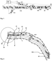
- Figure 1 shows a schematic situation of a plurality of road users, with position information of the current position of the road users and speed information of the road users being recorded on a route section 101 to determine the expected travel time or travel duration of the road users.
- Figure 2 Schematically individually designated road users 21, 22, 23, 24 is only one road user 24 in Figure 1 specifically designated.
- route section 101 is in Figure 2 further shown schematically how this is divided into a plurality of subsections, with between the transmitter 20 and the receiver 25 of the route section 101 or the geographical area 100 in Figure 1 a first subsection 102, a second subsection 103 and a third subsection 104 are shown, the first, second and third subsections 102, 103, 104 according to the exemplary illustration in Figure 1 are shown as arranged in a sequence against the direction of travel 101 'of road users on the section of route under consideration.
- FIG. 1 Further route sections 110, 111, 112 are shown, which lie or are arranged behind the currently traveled route section 101 in the direction of travel (and from the perspective of the road user 24).
- each of the road users 21, 22, 23, 24 is determined or assigned a respective provisional lane information
- in a second sub-step in the second step it is checked whether the provisional lane information needs to be adjusted or corrected, whereby, if the provisional lane information needs to be corrected, in a third sub-step of the second step, corrected lane information is provided for at least some of the road users 21 on the basis of the provisional lane information, 22, 23, 24 is determined or assigned, wherein in a fourth sub-step of the second step the corrected lane information is assigned as the lane information to the respective road user 21, 22, 23, 24.
- the second sub-step and the third sub-step are carried out repeatedly, in particular iteratively, checking whether the corrected lane information needs to be corrected again and, if so, further corrected lane information is determined or assigned for at least some of the road users 21, 22, 23, 24.
- the first and second steps for determining or assigning lane information are carried out either by the road user 21, 22, 23, 24 itself (or by a calculation device thereof) or by a device external to the road user 21, 22 , 23, 24 existing facility is carried out.
- the transmitter 20 as an authorized transmitter (eg at the radio mast of a network operator and at the starting point of the geographical area, for example a road section), periodically sends out an initial special broadcast message, the message content of the transmitter 20 to a plurality of receivers (road users 21, 22, 23, 24) as a broadcast message using a D2D functionality, device-to-device functionality or a PC5 sidelink functionality, in particular using Mode 4 functionality, is sent.
- the message is only enriched by vehicles (road users or receiving devices) on the road section of the geographical area 100 (defined in the initial broadcast message) and with the specified direction of travel 101 'with their own information (in particular position, speed, time stamp and vehicle type).
- a broadcast message (which can also be enriched by future recipients), whereby there can be (and usually will be) several chains of broadcast messages that are sent by the receiver 25 (or by the final receiver) when the end point of the road section is reached.
- a special receiving unit on the radio mast of a network operator are received and then processed into current traffic flow information for the road section.
- Each such chain of broadcast messages (which 'run' over or through the geographical area 100 to the receiver 25) is thus triggered or started by an initial special broadcast message, such initial special broadcast message being sent by the transmitter 20 according to the invention, in particular periodically (for example every 100, 200, 300, 400, 500, 600, 700 or 800 seconds or also every 2, 3, 4, 5, 8, 10, 12, 15, 18, 20, 25 or 30 minutes) are repeated (in particular using different, for example incremented, message identification information).
- the method combines a traffic system infrastructure with the definition of routes (sections) in a manner optimized for the method (and a dynamic adjustment), a V2X communication (according to 3GPP or ETSI standards) and a Data collection, data aggregation and data processing, especially with the use of broadcast waves.
- a vehicle wants to enter the route section, it receives a message wave with frequency f for this route section. If the FZG enters a route network, it can query the currently valid (most recently carried out) complete message wave for each of the route sections to be traveled from the V-Info system or a stationary transmitter (near) the entry point will receive the V-Info to all "coming" vehicles, e.g. via broadcast message, with a sufficiently high frequency.
- a truck that will/must drive in the right lane can potentially be predicted to have speeds that are too high. It is therefore the case that in conventionally known systems, in particular due to insufficiently good (or often completely missing) determination of a lane on a multi-lane road, the previously collected and further processed traffic information does not provide what is suggested by the information, namely the one suitable ( best possible) information for individual Road users.
Landscapes
- Physics & Mathematics (AREA)
- General Physics & Mathematics (AREA)
- Chemical & Material Sciences (AREA)
- Analytical Chemistry (AREA)
- Engineering & Computer Science (AREA)
- Computer Networks & Wireless Communication (AREA)
- Signal Processing (AREA)
- Traffic Control Systems (AREA)
Priority Applications (1)
| Application Number | Priority Date | Filing Date | Title |
|---|---|---|---|
| EP22176477.2A EP4287157A1 (fr) | 2022-05-31 | 2022-05-31 | Procédé de détermination ou d'attribution des informations de voie de circulation concernant plusieurs usagers de la route se trouvant sur un tronçon de route, réseau ou système de télécommunication, usager de la route, programme informatique et support lisible par ordinateur |
Applications Claiming Priority (1)
| Application Number | Priority Date | Filing Date | Title |
|---|---|---|---|
| EP22176477.2A EP4287157A1 (fr) | 2022-05-31 | 2022-05-31 | Procédé de détermination ou d'attribution des informations de voie de circulation concernant plusieurs usagers de la route se trouvant sur un tronçon de route, réseau ou système de télécommunication, usager de la route, programme informatique et support lisible par ordinateur |
Publications (1)
| Publication Number | Publication Date |
|---|---|
| EP4287157A1 true EP4287157A1 (fr) | 2023-12-06 |
Family
ID=81854788
Family Applications (1)
| Application Number | Title | Priority Date | Filing Date |
|---|---|---|---|
| EP22176477.2A Pending EP4287157A1 (fr) | 2022-05-31 | 2022-05-31 | Procédé de détermination ou d'attribution des informations de voie de circulation concernant plusieurs usagers de la route se trouvant sur un tronçon de route, réseau ou système de télécommunication, usager de la route, programme informatique et support lisible par ordinateur |
Country Status (1)
| Country | Link |
|---|---|
| EP (1) | EP4287157A1 (fr) |
Cited By (1)
| Publication number | Priority date | Publication date | Assignee | Title |
|---|---|---|---|---|
| US20240328793A1 (en) * | 2023-03-30 | 2024-10-03 | Zenseact Ab | Vehicle localization |
Citations (5)
| Publication number | Priority date | Publication date | Assignee | Title |
|---|---|---|---|---|
| US20110109475A1 (en) * | 2009-11-12 | 2011-05-12 | Gm Global Technology Operations, Inc. | Travel Lane Advisor |
| DE102011009812B3 (de) * | 2011-01-31 | 2012-05-03 | Audi Ag | Verfahren zur Übermittlung einer Verkehrsinformation an einen Informationsempfänger und Kraftfahrzeug |
| WO2018057393A1 (fr) * | 2016-09-23 | 2018-03-29 | Pcms Holdings, Inc. | Procédés et appareil pour notification de navigation améliorée sur la base d'un écoulement de circulation localisé |
| DE102014106048B4 (de) * | 2014-04-30 | 2018-06-14 | Deutsches Zentrum für Luft- und Raumfahrt e.V. | Verfahren zur Bestimmung der Position eines Verkehrsteilnehmers, Infrastruktureinrichtung, Fahrzeug und Computerprogramm |
| DE102019117705A1 (de) * | 2019-07-01 | 2021-01-07 | Bayerische Motoren Werke Aktiengesellschaft | Verfahren und Steuereinheit zur Darstellung einer Verkehrssituation durch Verkehrsteilnehmer-Symbole mit fixierter lateraler Position |
-
2022
- 2022-05-31 EP EP22176477.2A patent/EP4287157A1/fr active Pending
Patent Citations (5)
| Publication number | Priority date | Publication date | Assignee | Title |
|---|---|---|---|---|
| US20110109475A1 (en) * | 2009-11-12 | 2011-05-12 | Gm Global Technology Operations, Inc. | Travel Lane Advisor |
| DE102011009812B3 (de) * | 2011-01-31 | 2012-05-03 | Audi Ag | Verfahren zur Übermittlung einer Verkehrsinformation an einen Informationsempfänger und Kraftfahrzeug |
| DE102014106048B4 (de) * | 2014-04-30 | 2018-06-14 | Deutsches Zentrum für Luft- und Raumfahrt e.V. | Verfahren zur Bestimmung der Position eines Verkehrsteilnehmers, Infrastruktureinrichtung, Fahrzeug und Computerprogramm |
| WO2018057393A1 (fr) * | 2016-09-23 | 2018-03-29 | Pcms Holdings, Inc. | Procédés et appareil pour notification de navigation améliorée sur la base d'un écoulement de circulation localisé |
| DE102019117705A1 (de) * | 2019-07-01 | 2021-01-07 | Bayerische Motoren Werke Aktiengesellschaft | Verfahren und Steuereinheit zur Darstellung einer Verkehrssituation durch Verkehrsteilnehmer-Symbole mit fixierter lateraler Position |
Cited By (1)
| Publication number | Priority date | Publication date | Assignee | Title |
|---|---|---|---|---|
| US20240328793A1 (en) * | 2023-03-30 | 2024-10-03 | Zenseact Ab | Vehicle localization |
Similar Documents
| Publication | Publication Date | Title |
|---|---|---|
| EP3655799B1 (fr) | Procédé pour produire et améliorer une distribution de probabilités de position pour des données reçues par gnss | |
| EP3042368B1 (fr) | Procede, systeme d'evaluation et vehicule pour anticiper au moins un parametre d'un bouchon | |
| DE69917543T2 (de) | Verkehrsinformationübermittlungssystem | |
| EP2223504B1 (fr) | Transmission d'informations d'un véhicule | |
| DE112009001007B4 (de) | Kommunikationssystem | |
| DE102019101847B4 (de) | Genauigkeitssystem für vernetzte Fahrzeuge | |
| EP3398181B2 (fr) | Procédé pour faire fonctionner un réseau de communication comprenant plusieurs véhicules automobiles et véhicule automobile | |
| DE112015001944T5 (de) | Fahrzeugbordkommunikationsendgerät und mobiles Kommunikationssystem | |
| EP2660794A1 (fr) | Procédé et dispositifs destinés à l'identification dýun véhicule utilisant un lieu | |
| WO2016177481A1 (fr) | Procédé de validation de valeurs de mesure d'un appareil mobile | |
| DE102016205143B4 (de) | Verfahren, Vorrichtungen und Computerprogramme zum Anpassen einer direkten Fahrzeug-zu-Fahrzeug-Kommunikation | |
| DE102012214555A1 (de) | Verfahren und System zum Ausgleichen einer Zeitabweichung | |
| WO2010139806A1 (fr) | Procédé de localisation et unité de communication embarquée dans un véhicule | |
| DE102013001120A1 (de) | Verfahren zum Betreiben von Kraftfahrzeugen, die über eine Fahrzeug-zu-Fahrzeug-Kommunikation verbunden sind | |
| EP3298805A1 (fr) | Procédé, véhicule automobile et système de spécification d'un chemin de transmission | |
| DE102012009822A1 (de) | Verfahren zur Ermittlung einer Größe zur Beschreibung eines lokalenVerkehrs | |
| DE102008025707A1 (de) | Verfahren und Vorrichtung zum Bestimmen einer Verkehrsführungsinformation für ein Fahrzeug | |
| EP3427387B1 (fr) | Dispositif de commande et procédé de couplage d'un dispositif d'antenne multistandard d'un véhicule à moteur à au moins un composant de véhicule | |
| EP4287157A1 (fr) | Procédé de détermination ou d'attribution des informations de voie de circulation concernant plusieurs usagers de la route se trouvant sur un tronçon de route, réseau ou système de télécommunication, usager de la route, programme informatique et support lisible par ordinateur | |
| EP0484895A2 (fr) | Procédé de détermination de la position relative de véhicules circulants | |
| DE102020200023B4 (de) | Verfahren und Vorrichtung zur hochgenauen Bestimmung der Position und/oder Orientierung eines zu ortenden Objektes sowie Feststation für ein Mobilfunkkommunikationssystem | |
| EP3096305B1 (fr) | Procédé de calcul de vitesse de véhicules et vérification autonome de plausibilité | |
| EP4287155B1 (fr) | Procédé de détection d'une situation de circulation dans une zone géographique par transmission d'un contenu de message, réseau ou système de télécommunication, usager de la route, programme informatique et support lisible par ordinateur | |
| EP3389291A1 (fr) | Communication entre un véhicule et une pluralité de dispositifs de route | |
| EP4287156A1 (fr) | Procédé de détermination du temps de déplacement des usagers de la route sur un tronçon de route par détection des informations de position de la position actuelle des usagers de la route et des informations de vitesse des usagers de la route, réseau de télécommunication ou système, usager de la route, programme informatique et support lisible par ordinateur |
Legal Events
| Date | Code | Title | Description |
|---|---|---|---|
| PUAI | Public reference made under article 153(3) epc to a published international application that has entered the european phase |
Free format text: ORIGINAL CODE: 0009012 |
|
| STAA | Information on the status of an ep patent application or granted ep patent |
Free format text: STATUS: REQUEST FOR EXAMINATION WAS MADE |
|
| 17P | Request for examination filed |
Effective date: 20230511 |
|
| AK | Designated contracting states |
Kind code of ref document: A1 Designated state(s): AL AT BE BG CH CY CZ DE DK EE ES FI FR GB GR HR HU IE IS IT LI LT LU LV MC MK MT NL NO PL PT RO RS SE SI SK SM TR |
|
| STAA | Information on the status of an ep patent application or granted ep patent |
Free format text: STATUS: EXAMINATION IS IN PROGRESS |
|
| 17Q | First examination report despatched |
Effective date: 20241220 |