EP0429783A2 - Méthode de poursuite des signaux reçus des satellites GPS dans des récepteurs GPS - Google Patents
Méthode de poursuite des signaux reçus des satellites GPS dans des récepteurs GPS Download PDFInfo
- Publication number
- EP0429783A2 EP0429783A2 EP90117374A EP90117374A EP0429783A2 EP 0429783 A2 EP0429783 A2 EP 0429783A2 EP 90117374 A EP90117374 A EP 90117374A EP 90117374 A EP90117374 A EP 90117374A EP 0429783 A2 EP0429783 A2 EP 0429783A2
- Authority
- EP
- European Patent Office
- Prior art keywords
- frequency
- satellite
- gps
- receiving
- search
- Prior art date
- Legal status (The legal status is an assumption and is not a legal conclusion. Google has not performed a legal analysis and makes no representation as to the accuracy of the status listed.)
- Granted
Links
- 238000000034 method Methods 0.000 title claims abstract description 21
- 238000001228 spectrum Methods 0.000 description 3
- 230000000694 effects Effects 0.000 description 1
- 238000012986 modification Methods 0.000 description 1
- 230000004048 modification Effects 0.000 description 1
Images
Classifications
-
- G—PHYSICS
- G01—MEASURING; TESTING
- G01S—RADIO DIRECTION-FINDING; RADIO NAVIGATION; DETERMINING DISTANCE OR VELOCITY BY USE OF RADIO WAVES; LOCATING OR PRESENCE-DETECTING BY USE OF THE REFLECTION OR RERADIATION OF RADIO WAVES; ANALOGOUS ARRANGEMENTS USING OTHER WAVES
- G01S19/00—Satellite radio beacon positioning systems; Determining position, velocity or attitude using signals transmitted by such systems
- G01S19/01—Satellite radio beacon positioning systems transmitting time-stamped messages, e.g. GPS [Global Positioning System], GLONASS [Global Orbiting Navigation Satellite System] or GALILEO
- G01S19/13—Receivers
- G01S19/24—Acquisition or tracking or demodulation of signals transmitted by the system
- G01S19/29—Acquisition or tracking or demodulation of signals transmitted by the system carrier including Doppler, related
Definitions
- the present invention relates to a method of tracking satellite signals for Global Positioning System (GPS) receivers.
- GPS Global Positioning System
- Positioning systems currently in service utilizing artificial satellites include a so-called Global Positioning System (GPS).
- GPS Global Positioning System
- This positioning system will cover the entire surface of the Globe by a total of 24 geodetic satellites when all of them are operational on six orbits, approximately 20,200 km above the Earth, which will accommodate four geodetic satellites each.
- Each geodetic satellite transmits a GPS signal containing navigation data for reckoning to the Earth using a spread-spectrum system.
- the reckoning is carried out on the ground, on the sea as well as in the air by receiving GPS signals from a plurality of geodetic satellites, for example, by receiving GPS signals from three geodetic satellites for two-dimensional positioning and that from four geodetic satellites for three-dimensional positioning. In this way, based upon the navigation data contained in the GPS signal from each geodetic satellite, position information on the receiving point such as a latitude, longitude and altitude thereof can be reckoned in real time.
- This GPS system was originally developed for U.S. military use, however, a part of the GPS signal (C/A code) has been made available for civil use. Therefore, it is possible to build navigation systems for automobiles, ships and aircraft by using the GPS signal.
- a GPS receiver used for a vehicle-mounted navigation equipment starts a search operation to recapture the GPS satellite when the vehicle enters a tunnel, for example, and the reception of the GPS signals from the GPS satellites is interrupted for more than a specified period of time (for example, one minute).
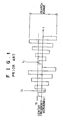
- the GPS satellites are not geostationary, so that the satellite signal receiving frequency may be shifted by the Doppler effect. Therefore, as shown in Fig. 1, in order to search for satellite signals, it has been required to change a search frequency in succession over a maximum frequency range of the Doppler frequency shift being centered on a center frequency (1575.42 Mhz) of a satellite signal.
- the satellite signals are transmitted by the spread-spectrum system. Therefore, the reception of the satellite signal must be initiated by locking a phased-lock loop (PLL) circuit of the GPS receiver on the exact receiving frequency of the satellite signal at every stepwise change-over of the search frequency. Upon successful locking of the PLL circuit, the spread-spectrum signal is despread to receive the GPS signal. This means that even when the satellite signal has arrived at the GPS receiver, it is not able to receive the GPS signal without any delay.
- PLL phased-lock loop
- the PLL circuit of the GPS receiver will lock on the receiving frequency fr at time t2, which corresponds to eighth stepwise search frequency change after the time t1, thus permitting the GPS receiver to recapture the GPS satellite.
- the conventional GPS receiver cannot discriminate a difference between a state of no reception caused by the incompletion of locking the PLL circuit on the receiving frequency or the failure of despreading for the received signal and a state of no reception caused by the lack of satellite signals themselves as the vehicle enters a tunnel and the like. Because of this ambiguity, the conventional GPS receiver is not capable of dealing with the interruption of the receiving signal, such as when the vehicle is in the tunnel, in a proper way, so that it takes a considerable time for the GPS receiver to recapture the GPS satellite after the vehicle passing through the tunnel, causing a problem in positioning.
- the satellite signal tracking method of this invention decides that the mobile GPS receiver has entered a dead zone like a tunnel for signal reception. At this moment, the GPS receiver chooses, as a target, only one satellite that is estimated to have the maximum elevation angle, and attempts to recapture it.
- a first preferred method for recapturing the satellite at the highest elevation angle involves in dividing a search range of satellite signal receiving frequency into a plurality of bands, assigning these bands to the plurality of receiving channels in a one-to-one relationship, and changing the search frequency within the allocated frequency band for each receiving channel to search for a signal from the GPS satellite with the maximum elevation angle.
- a second preferred method for recapturing the GPS satellite at the maximum elevation angle involves in dealing with a search for the satellite signal transmitted by assigning a specific time difference for step change-over timing of the search frequency in each receiving channel, and changing the search frequency of each receiving channel across the overall width of the search range for the receiving frequency of the satellite signal.
- the search range for the receiving frequency of the satellite signal is subdivided into a plurality of bands, which are then assigned to a plurality of channels on a one-to-one basis, the search range allocated to each channel is narrowed, and thereby reducing the time required for making a complete one round of search frequency change. Therefore, it is possible to reduce the time required for recapturing the GPS satellite to the extent that is reduced by the time taken in one round of the search frequency change.
- the search frequency in each receiving channel is varied across the overall width of the search range by giving a time difference to the step change-over timing of the search frequency for each receiving channel.
- Fig. 1 is a time chart of step change-over for the search frequency performed by a conventional GPS receiver
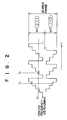
- Fig. 2 is a time chart of a first embodiment of the invention showing a timing at which the search frequency is changed stepwise;
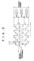
- Fig. 3 is a time chart of a second embodiment of the invention showing a timing of changing the search frequency stepwise;
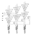
- Fig. 4 is a time chart of a third embodiment of the invention showing a timing of changing the search frequency stepwise.
- Fig. 2 is a time chart showing a change-over timing for the search frequency embodying the present invention.
- This first embodiment has a first preferred satellite tracking method of this invention applied to a GPS receiver equipped with two receiving channels.
- the search range of the satellite signal receiving frequency is divided into upper and lower frequency bands W1 and W2, whereby the upper frequency band W1 is assigned to a channel CH1 and that the lower frequency band W2 to a channel CH2, in order to carry out the simultaneous search for satellite signals in each channel.
- the GPS receiver When a vehicle carrying the GPS receiver enters a tunnel and there is no reception of signals from all GPS satellites for a specified period of time, for example, 1 minute, the GPS receiver is then brought into operation for searching GPS satellites in accordance with this invention, wherein a GPS satellite having the maximum angle of elevation is predicted at that moment.
- a GPS satellite having the maximum angle of elevation In order to predict the GPS satellite having the maximum elevation, there required is the following information for the GPS receiver:
- the clock in the GPS receiver or the clock built into the vehicle can be used.
- position information of item (2) coordinates such as the latitude and longitude of Tokyo, for example, may be stored in a ROM (Read Only Memory) installed in the GPS receiver.
- almanac information of item (3) the almanac information of the GPS satellite that was received just before the signal became unreadable can be used. From these information, it is possible to predict the orbital positions of all GPS satellites by executing the known satellite orbit calculating algorithm, and thereby the GPS satellite which has the highest elevation angle is determined at that moment.
- the search operation to capture the predicted GPS satellite is initiated simultaneously through the two channels CH1 and CH2 of the GPS receiver.
- the search frequency in channel CH1 becomes a frequency that can be locked to the receiving frequency fr at time t2 which corresponds to the third step change-over of the search frequency after time t1.
- the PLL circuit of the channel CH1 is locked to the receiving frequency fr and the GPS satellite is recaptured.
- the locking of a PLL circuit to the receiving frequency fr of the GPS satellite occurs at time t2, where is eighth step change-over of the search frequency after time t1 when the vehicle came out of the tunnel, as shown in Fig. 1.
- the first embodiment of this invention is capable of recapturing the GPS satellite within one half of the time required by the conventional GPS receiver in terms of probability.
- the positioning requires three or four GPS satellites and, once the GPS satellite at the maximum elevation angle is recaptured, the almanac information contained in the GPS signal from the GPS satellite can be used to determine the accurate current orbital positions of all other GPS satellites, thus making it extremely easy to locate other GPS satellites required for reckoning. Therefore, when the GPS satellite at the maximum elevation angle is successfully captured, the satellite search operation according to this invention is terminated and switched over to the normal reception mode whereby the signals from a plurality of GPS satellites are sequentially received in each channel.
- Fig. 3 is a time chart showing a timing for changing the search frequency stepwise according to a second embodiment of the invention.
- the second embodiment is provided by applying the first GPS satellite recapturing method as described above to the GPS receiver having three receiving channels.
- the search range is divided into three frequency bands W1, W2 and W3, whereby the upper frequency band W1 is assigned to a channel 1, the middle frequency band W2 is assigned to a channel 2 and the lower frequency band W3 is assigned to a channel 3 for searching GPS satellites. Since the GPS satellite search operation is carried out in each of the three channels at the same time, according to the second embodiment of this invention, the GPS satellite can be recaptured within approximately one third of the time required for the conventional GPS receiver to locate the GPS satellite in terms of probability.
- Fig. 4 is a time chart illustrating a timing for changing the search frequency stepwise according to a third embodiment of this invention.
- the third embodiment of this invention is provided by applying the second GPS satellite recapturing method as described above to a GPS receiver having three receiving channels.
- the search frequency in each channels is successively changed stepwise across the overall width of the search range for the satellite signal in order to catch the satellite signal. Therefore, even if none of the receiving channels CH1 to CH3 was able to lock to the satellite signal receiving frequency at time t1 when, for example, the vehicle came out of the tunnel, the satellite signal can be locked by, at least, one of the three receiving channels, in the embodiment of Fig. 4, by the receiving channel CH2 at time t2 within ⁇ T from time t1.
- the third embodiment can be reduced the time required for recapturing the GPS satellite to approximately one third of the time required by the conventional GPS receiver in terms of probability.
- the advantages of this invention may be summarized as follows.
- the tracking method in accordance with this invention allows the GPS receiver to quicken the recapturing of a GPS satellite at the maximum elevation angle which is of the easiest one to catch. This in turn enables the GPS receiver to restart the positioning immediately after the vehicle coming out of an obstacle.
Landscapes
- Engineering & Computer Science (AREA)
- Radar, Positioning & Navigation (AREA)
- Remote Sensing (AREA)
- Computer Networks & Wireless Communication (AREA)
- Physics & Mathematics (AREA)
- General Physics & Mathematics (AREA)
- Position Fixing By Use Of Radio Waves (AREA)
Applications Claiming Priority (2)
| Application Number | Priority Date | Filing Date | Title |
|---|---|---|---|
| JP308884/89 | 1989-11-30 | ||
| JP1308884A JPH0748076B2 (ja) | 1989-11-30 | 1989-11-30 | Gps受信機の衛星電波捕捉方法 |
Publications (3)
| Publication Number | Publication Date |
|---|---|
| EP0429783A2 true EP0429783A2 (fr) | 1991-06-05 |
| EP0429783A3 EP0429783A3 (en) | 1992-07-08 |
| EP0429783B1 EP0429783B1 (fr) | 1995-07-19 |
Family
ID=17986422
Family Applications (1)
| Application Number | Title | Priority Date | Filing Date |
|---|---|---|---|
| EP90117374A Expired - Lifetime EP0429783B1 (fr) | 1989-11-30 | 1990-09-10 | Méthode de poursuite des signaux reçus des satellites GPS dans des récepteurs GPS |
Country Status (4)
| Country | Link |
|---|---|
| US (1) | US5059969A (fr) |
| EP (1) | EP0429783B1 (fr) |
| JP (1) | JPH0748076B2 (fr) |
| DE (1) | DE69021016D1 (fr) |
Cited By (6)
| Publication number | Priority date | Publication date | Assignee | Title |
|---|---|---|---|---|
| AU654218B2 (en) * | 1991-11-29 | 1994-10-27 | Sony Corporation | GPS receiver |
| EP0635728A1 (fr) * | 1993-07-22 | 1995-01-25 | Trimble Navigation Limited | Méthodes de recherche pour satellites pour améliorer le temps necessaire pour la première localisation de la position d'un récepteur GPS |
| EP0442341B1 (fr) * | 1990-02-13 | 1995-08-02 | Pioneer Electronic Corporation | Récepteur GPS |
| WO1996002092A1 (fr) * | 1994-07-11 | 1996-01-25 | Qualcomm Incorporated | Procede d'acquisition rapide de signaux dans un systeme de telecommunications par satellite |
| EP1109033A4 (fr) * | 1999-06-16 | 2006-06-14 | Mitsubishi Electric Corp | Recepteur gps, systeme de detection de position et determination de position |
| WO2017097794A1 (fr) * | 2015-12-11 | 2017-06-15 | Audi Ag | Détermination assistée par satellite de la position d'un véhicule automobile dans une zone couverte |
Families Citing this family (19)
| Publication number | Priority date | Publication date | Assignee | Title |
|---|---|---|---|---|
| US8352400B2 (en) | 1991-12-23 | 2013-01-08 | Hoffberg Steven M | Adaptive pattern recognition based controller apparatus and method and human-factored interface therefore |
| US10361802B1 (en) | 1999-02-01 | 2019-07-23 | Blanding Hovenweep, Llc | Adaptive pattern recognition based control system and method |
| US5408239A (en) * | 1992-03-16 | 1995-04-18 | Pioneer Electronic Corporation | Method for setting search band widths of a GPS receiver |
| US5917444A (en) * | 1995-05-22 | 1999-06-29 | Trimble Navigation Ltd. | Reduction of time to first fix in an SATPS receiver |
| USRE37408E1 (en) * | 1993-05-21 | 2001-10-16 | Trimble Navigation Ltd. | Reduction of time to first fix in an SATPS receiver |
| US5418538A (en) * | 1993-05-21 | 1995-05-23 | Trimble Navigation Limited | Rapid satellite signal acquisition in a satellite positioning system |
| US5594453A (en) * | 1994-11-01 | 1997-01-14 | Trimble Navigation, Ltd | GPS receiver having a rapid acquisition of GPS satellite signals |
| US6122482A (en) * | 1995-02-22 | 2000-09-19 | Global Communications, Inc. | Satellite broadcast receiving and distribution system |
| US5969595A (en) * | 1996-07-22 | 1999-10-19 | Trimble Navigation Limited | Security for transport vehicles and cargo |
| US5959575A (en) * | 1997-11-04 | 1999-09-28 | Nortrhop Grumman Corporation | Interior GPS navigation |
| US7268700B1 (en) | 1998-01-27 | 2007-09-11 | Hoffberg Steven M | Mobile communication device |
| US6239721B1 (en) | 1998-10-26 | 2001-05-29 | Trimble Navigation Limited | Bootstrapped location determination |
| US7904187B2 (en) | 1999-02-01 | 2011-03-08 | Hoffberg Steven M | Internet appliance system and method |
| CA2404109C (fr) * | 2000-03-20 | 2011-04-26 | Qualcomm Incorporated | Procedes et appareils pour l'utilisation de donnees relatives a des systemes de positionnement par satellite |
| JP3491631B2 (ja) * | 2001-11-28 | 2004-01-26 | 株式会社デンソー | 無線通信端末 |
| US9818136B1 (en) | 2003-02-05 | 2017-11-14 | Steven M. Hoffberg | System and method for determining contingent relevance |
| US9121937B2 (en) | 2011-12-29 | 2015-09-01 | Google Technology Holdings LLC | Method and apparatus for tracking a global navigation satellite system within the constraints of an indoor facility |
| KR101564828B1 (ko) * | 2014-01-20 | 2015-10-30 | 한국과학기술원 | 도플러 주파수가 있는 미약한 대역확산 신호의 초고속 신호 획득 및 추적을 위한 신호 처리 방법 및 그 장치 |
| CN107919902A (zh) * | 2017-10-18 | 2018-04-17 | 广州视源电子科技股份有限公司 | Diseqc设备的端口设置方法及装置、可读存储介质及电视机 |
Family Cites Families (12)
| Publication number | Priority date | Publication date | Assignee | Title |
|---|---|---|---|---|
| US4445118A (en) * | 1981-05-22 | 1984-04-24 | The United States Of America As Represented By The Administrator Of The National Aeronautics And Space Administration | Navigation system and method |
| US4453165A (en) * | 1983-01-03 | 1984-06-05 | Sperry Corporation | Differential Doppler receiver |
| JPH0640126B2 (ja) * | 1984-07-25 | 1994-05-25 | ソニー株式会社 | 測位装置 |
| US4701934A (en) * | 1985-09-03 | 1987-10-20 | Motorola, Inc. | Method of doppler searching in a digital GPS receiver |
| US4785463A (en) * | 1985-09-03 | 1988-11-15 | Motorola, Inc. | Digital global positioning system receiver |
| JPS6295478A (ja) * | 1985-10-23 | 1987-05-01 | Hitachi Ltd | Gps受信システム |
| JPS62189678U (fr) * | 1986-05-26 | 1987-12-02 | ||
| US4924402A (en) * | 1986-07-02 | 1990-05-08 | Pioneer Electronic Corporation | Method for identifying current position of vehicle |
| DE3736386A1 (de) * | 1986-10-27 | 1988-07-14 | Pioneer Electronic Corp | Fahrzeugpeilverfahren |
| DE3716329A1 (de) * | 1987-05-15 | 1988-12-01 | Dornier System Gmbh | Verfahren zur akquisition von signalen |
| US4837700A (en) * | 1987-10-27 | 1989-06-06 | Pioneer Electronic Corporation | Method and apparatus for processing data in a GPS receiving device in a road vehicle |
| JPH03146890A (ja) * | 1989-11-02 | 1991-06-21 | Pioneer Electron Corp | Gps受信機の衛星電波捕捉方式 |
-
1989
- 1989-11-30 JP JP1308884A patent/JPH0748076B2/ja not_active Expired - Fee Related
-
1990
- 1990-09-07 US US07/578,919 patent/US5059969A/en not_active Expired - Fee Related
- 1990-09-10 DE DE69021016T patent/DE69021016D1/de not_active Expired - Lifetime
- 1990-09-10 EP EP90117374A patent/EP0429783B1/fr not_active Expired - Lifetime
Cited By (9)
| Publication number | Priority date | Publication date | Assignee | Title |
|---|---|---|---|---|
| EP0442341B1 (fr) * | 1990-02-13 | 1995-08-02 | Pioneer Electronic Corporation | Récepteur GPS |
| AU654218B2 (en) * | 1991-11-29 | 1994-10-27 | Sony Corporation | GPS receiver |
| EP0635728A1 (fr) * | 1993-07-22 | 1995-01-25 | Trimble Navigation Limited | Méthodes de recherche pour satellites pour améliorer le temps necessaire pour la première localisation de la position d'un récepteur GPS |
| WO1996002092A1 (fr) * | 1994-07-11 | 1996-01-25 | Qualcomm Incorporated | Procede d'acquisition rapide de signaux dans un systeme de telecommunications par satellite |
| US5666122A (en) * | 1994-07-11 | 1997-09-09 | Qualcomm Incorporated | Method for rapid signal acquisition in a satellite communications system |
| CN1078023C (zh) * | 1994-07-11 | 2002-01-16 | 夸尔柯姆股份有限公司 | 在卫星通信系统中迅速捕获信号的方法 |
| EP1109033A4 (fr) * | 1999-06-16 | 2006-06-14 | Mitsubishi Electric Corp | Recepteur gps, systeme de detection de position et determination de position |
| WO2017097794A1 (fr) * | 2015-12-11 | 2017-06-15 | Audi Ag | Détermination assistée par satellite de la position d'un véhicule automobile dans une zone couverte |
| US10466365B2 (en) | 2015-12-11 | 2019-11-05 | Audi Ag | Satellite-based determination of a motor vehicle in a covered area |
Also Published As
| Publication number | Publication date |
|---|---|
| EP0429783B1 (fr) | 1995-07-19 |
| JPH03170890A (ja) | 1991-07-24 |
| JPH0748076B2 (ja) | 1995-05-24 |
| US5059969A (en) | 1991-10-22 |
| DE69021016D1 (de) | 1995-08-24 |
| EP0429783A3 (en) | 1992-07-08 |
Similar Documents
| Publication | Publication Date | Title |
|---|---|---|
| US5059969A (en) | Gps satellite signal tracking method for gps receivers | |
| EP0429769B1 (fr) | Méthode de suivi de signaux radio émanant de satellites dans un récepteur GPS | |
| US5177490A (en) | Gps satellite signal tracking system for gps receivers | |
| US4983980A (en) | Satellite radio signal tracking method for GPS receivers | |
| US5155491A (en) | Satellite radio signal tracking method for gps receivers | |
| US4928107A (en) | Signal receiving method for a user's device in a global positioning system | |
| EP0635728B1 (fr) | Méthodes de recherche pour satellites pour améliorer le temps necessaire pour la première localisation de la position d'un récepteur GPS | |
| US5418538A (en) | Rapid satellite signal acquisition in a satellite positioning system | |
| US6459405B1 (en) | Satellite-based location system employing knowledge-based sequential signal search strategy | |
| US6535801B1 (en) | Method and apparatus for accurately determining the position of satellites in geosynchronous orbits | |
| US7764224B1 (en) | Advanced spoofer mitigation and geolocation through spoofer tracking | |
| CN1202053A (zh) | 利用gps卫星系统快速而精确的蜂窝式电话机地理定位 | |
| WO1994023505A1 (fr) | Traitement par boucle vectorielle a retard de phase des signaux d'un emetteur de radiolocalisation | |
| JPH0815266B2 (ja) | 衛星を利用した無線交信システムおよびメッセージ伝達方法 | |
| JP2000249754A (ja) | Gps受信機用のジャミング検出およびブランキング | |
| US3172108A (en) | Method of navigation | |
| US7369599B2 (en) | Method and apparatus for reducing code phase search space | |
| RU2194363C2 (ru) | Способ автономного понижения порогов приема и сопровождения кодов расширения спектра, принимаемых на орбите | |
| JPH0797131B2 (ja) | Gps受信機の衛星電波捕捉方法 | |
| JPH03295483A (ja) | Gps受信機の衛星電波捕捉方式 | |
| JPH0756509B2 (ja) | Gps受信機の衛星電波捕捉方法 | |
| Rodriguez et al. | Lunar Transfer Missions Navigation using GNSS Software Receivers | |
| Hofmann-Wellenhof et al. | Overview of GPS | |
| Hofmann-Wellenhof et al. | Overview of GPS | |
| HK1057781A1 (zh) | 減少編碼相位搜索空間的方法和裝置 |
Legal Events
| Date | Code | Title | Description |
|---|---|---|---|
| PUAI | Public reference made under article 153(3) epc to a published international application that has entered the european phase |
Free format text: ORIGINAL CODE: 0009012 |
|
| AK | Designated contracting states |
Kind code of ref document: A2 Designated state(s): DE FR GB |
|
| PUAL | Search report despatched |
Free format text: ORIGINAL CODE: 0009013 |
|
| AK | Designated contracting states |
Kind code of ref document: A3 Designated state(s): DE FR GB |
|
| 16A | New documents despatched to applicant after publication of the search report | ||
| 17P | Request for examination filed |
Effective date: 19921008 |
|
| 17Q | First examination report despatched |
Effective date: 19940311 |
|
| GRAA | (expected) grant |
Free format text: ORIGINAL CODE: 0009210 |
|
| AK | Designated contracting states |
Kind code of ref document: B1 Designated state(s): DE FR GB |
|
| PG25 | Lapsed in a contracting state [announced via postgrant information from national office to epo] |
Ref country code: FR Effective date: 19950719 |
|
| REF | Corresponds to: |
Ref document number: 69021016 Country of ref document: DE Date of ref document: 19950824 |
|
| PG25 | Lapsed in a contracting state [announced via postgrant information from national office to epo] |
Ref country code: GB Effective date: 19951019 |
|
| PG25 | Lapsed in a contracting state [announced via postgrant information from national office to epo] |
Ref country code: DE Effective date: 19951020 |
|
| EN | Fr: translation not filed | ||
| PLBE | No opposition filed within time limit |
Free format text: ORIGINAL CODE: 0009261 |
|
| STAA | Information on the status of an ep patent application or granted ep patent |
Free format text: STATUS: NO OPPOSITION FILED WITHIN TIME LIMIT |
|
| GBPC | Gb: european patent ceased through non-payment of renewal fee |
Effective date: 19951019 |
|
| 26N | No opposition filed |