EP0435522B1 - Bildstellungsidentifizierungssgerät - Google Patents
Bildstellungsidentifizierungssgerät Download PDFInfo
- Publication number
- EP0435522B1 EP0435522B1 EP90313611A EP90313611A EP0435522B1 EP 0435522 B1 EP0435522 B1 EP 0435522B1 EP 90313611 A EP90313611 A EP 90313611A EP 90313611 A EP90313611 A EP 90313611A EP 0435522 B1 EP0435522 B1 EP 0435522B1
- Authority
- EP
- European Patent Office
- Prior art keywords
- point data
- data
- map
- control point
- image
- Prior art date
- Legal status (The legal status is an assumption and is not a legal conclusion. Google has not performed a legal analysis and makes no representation as to the accuracy of the status listed.)
- Expired - Lifetime
Links
Images

Classifications
-
- G—PHYSICS
- G06—COMPUTING OR CALCULATING; COUNTING
- G06T—IMAGE DATA PROCESSING OR GENERATION, IN GENERAL
- G06T7/00—Image analysis
-
- G—PHYSICS
- G06—COMPUTING OR CALCULATING; COUNTING
- G06V—IMAGE OR VIDEO RECOGNITION OR UNDERSTANDING
- G06V10/00—Arrangements for image or video recognition or understanding
- G06V10/70—Arrangements for image or video recognition or understanding using pattern recognition or machine learning
- G06V10/74—Image or video pattern matching; Proximity measures in feature spaces
- G06V10/75—Organisation of the matching processes, e.g. simultaneous or sequential comparisons of image or video features; Coarse-fine approaches, e.g. multi-scale approaches; using context analysis; Selection of dictionaries
- G06V10/757—Matching configurations of points or features
-
- G—PHYSICS
- G06—COMPUTING OR CALCULATING; COUNTING
- G06V—IMAGE OR VIDEO RECOGNITION OR UNDERSTANDING
- G06V30/00—Character recognition; Recognising digital ink; Document-oriented image-based pattern recognition
- G06V30/40—Document-oriented image-based pattern recognition
- G06V30/42—Document-oriented image-based pattern recognition based on the type of document
- G06V30/422—Technical drawings; Geographical maps
Definitions
- the present invention relates to an image location identification apparatus for matching image data taken by an imaging televion camera (ITV) with a corresponding map stored on a data base.
- ITV imaging televion camera
- a fire spot is taken by ITV from the sky.
- the image data and its global location data (latitude, longitude and angle of direction of view) are sent to a host computer where a map corresponding to the image data is retrieved from a map data base, according to the global location data.
- the image data is matched with the map, which includes houses, buildings and road data, on display. Therefore, according to the outbreak point of a fire, the path of a fire after a prescribed time can be simulated on the map. Then, against the path simulation, lead way and refuge places for inhabitants are determined.
- an image location identification apparatus comprising:
- Figure 1 shows the construction of an image location identification apparatus according to the present invention.
- Image data 1 is a video signal which is taken by an ITV mounted in a helicopter.
- Image processing section 2 quantize 512 x 512 pixels for the image data 1 and stores them. Then the section 2 extracts control points for location identification from quantized image data under the control of CPU 5.
- Location information 4 is global location, such as latitude, longitude and height, measured by the global positioning system or inertial navigation system of the helicopter.
- the location information 4 also includes camera parameters, such as direction and angle of view.
- Map data base 6 comprises memorized maps of the area being monitored which have global location data in the form of latitude and longitude for retrieval. Each map also includes data of roads, buildings, houses and many control points for location identification.
- CPU 5 controls all the other sections 1, 2, 3, 4, 6 and retrieves a map corresponding to the image data 1 from the map data base 6, according to the location information 4. Then CPU 5 identifies the location between the image data 1 and the retrieved map, according to predetermined control points of the retrieved map and control points of the image data extracted by the image processing section 2. Lastly, CPU 5 makes the image data 1 match with the map on display section 3.
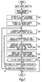
- Figure 2 shows a flow chart of the process for identifying image location.
- image data 1 is quantized and stored in the image processing section 2 (step 201).
- location information 4 a map area corresponding approximately to the image data 1 is determined and the map is retrieved, having area to spare (for example, 200 m extra width at the top and bottom and left and right sides (step 202, 203).
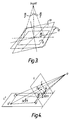
- map area of map data base 6 will be explained, assuming that the latitude, longitude and height of the image taking position are X, Y Z. Furthermore, ⁇ and ⁇ represent the visual field angle directions of the camera. Secondly, area 12 which includes an admissible error limit against the area 11 is calculated. Finally, area 13 is the area 12 rotated in the direction of the angle obtained from the direction data.
- intersections of main roads are extracted (step 204).
- the colour and shape of roads are different from those of buildings, parks, or green zones, and so on. Therefore, the roads as regions having a character of a predetermined colour and figure is extracted. Then the central line of each road is extracted as a control point. In this case, it is not necessary for all road regions and all cross points to be extracted, and a minimum of road regions and cross points for location identification may be extracted.
- Coefficients b1 - b8 of above transformation formula are calculated by providing at least four control points corresponding to image data 1 and retrieval map data.
- four control points of image data L are A, B, C, D and four control points of retrieval map L' are A', B', C', D'.
- the procedure sequentially calculates the transformation coefficients with respect to all the possible combinations of the reference points on the image data for calculating the coefficients and any four reference points of the twenty three reference points (1 - 23) on the map data (step 205, step 206 and step 207).
- the procedure calculates the co-ordinates of the reference points for verification on the map data by use of the thus calculated transformation coefficients. Further the procedure judges the authenticity of the transformation coefficients by verifying whether or not the reference points of the map data are present in the vicinity of their corresponding positions (step 208).
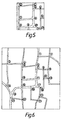
- transformation coefficients between co-ordinate systems of the image data and the map are calculated by using four control points (2, 4, 8, 11) of the image data and the first permutation of selected four control points of the map (step 207). Then, by using the transformation coefficient, a co-ordinate point corresponding to the other control points (1, 3, 5, 6, 7, 9, 10) of the image data is calculated on the map and it is determined whether the predetermined control point is situated near the co-ordinate point on the map (step 208). If the predetermined controls points are situated near all of the co-ordinate points on the map, respectively, the transformation coefficient is correct (step 209). Therefore, according to the corresponding control points, the image data is matched with the map on the display section 3.
- step 207, 208, 209, 210 a second permutation of the selected four control points, using the above-mentioned processing. If the transformation coefficient is not correct as for all permutations of the selected four points, another four control points are selected from the control points (1 - 23) in the map (step 211). As for the second selected four control points, the above-mentioned processing (step 206, 207, 208, 209, 210) is repeated. This process is repeated until a correct transformation coefficient is found with a different four control points selected, in turn, and the above-mentioned processing being repeated.
- first four control points (1, 2, 3, 4) are selected from predetermined control points (1 - 23). All permutation of the first four control points are (1, 2, 3, 4), (1, 2, 4, 3), (1, 3, 2, 4), (1, 3, 4, 2), (1, 4, 2, 3), (1, 4, 3, 2,), (2, 1, 3, 4), (2, 1, 4, 3), (2, 3, 1, 4), (2, 3, 4, 1), (2, 4, 1, 3), (2, 4, 3, 1), (3, 1, 2, 4), (3, 1, 4, 2,), (3, 2, 1, 4), (3, 2, 4, 1), (3, 4, 1, 2), (3, 4, 2, 1), (4, 1, 2, 3), (4, 1, 3, 2), (4, 2, 1, 3), (4, 2, 3, 1), (4, 3, 1, 2), (4, 3, 2, 1).
- transformation coefficients between each permutation and the four control points (2, 4, 8, 11) of the image data (as shown in Figure 5) are calculated, taking account of the control points order.
- the second four control points (1, 2, 3, 5) are selected from predetermined control points (1 - 23) of the map, and all permutations of the second four control points (1, 2, 3, 5) are formed and each transformation coefficient is calculated for all permutations.
- the transformation coefficient is correct.
- the transformation coefficient between four control points (6, 8, 15, 18) on the map and four control points (2, 4, 8, 11) on the image data is calculated.
- co-ordinate points corresponding to control points (1, 3, 5, 6, 7, 9, 10) for verifying on the image data are situated just as predetermined control points (5, 7, 10, 11, 12, 16, 17) on the map.
- the image data is matched with the map automatically and the image data and the map, when they are matched, are displayed on the display section 3.
Landscapes
- Engineering & Computer Science (AREA)
- Computer Vision & Pattern Recognition (AREA)
- Theoretical Computer Science (AREA)
- Physics & Mathematics (AREA)
- General Physics & Mathematics (AREA)
- Artificial Intelligence (AREA)
- Multimedia (AREA)
- Computing Systems (AREA)
- Health & Medical Sciences (AREA)
- Databases & Information Systems (AREA)
- Evolutionary Computation (AREA)
- General Health & Medical Sciences (AREA)
- Medical Informatics (AREA)
- Software Systems (AREA)
- Processing Or Creating Images (AREA)
- Information Retrieval, Db Structures And Fs Structures Therefor (AREA)
- Image Processing (AREA)
Claims (10)
- Bild-Ortsidentifizierungsvorrichtung mit:Bildeingabemitteln (1, 4) zum Eingeben von Bilddaten und entsprechenden globalen Ortsdaten;Kartenspeichermitteln (6) zum Speichern einer Mehrzahl von Karten, welche Karten jeweils globale Ortsdaten und Kontrollpunktdaten aufweisen;Abrufmitteln (5) zum Abrufen einer gespeicherten Karte, deren globale Ortsdaten mit den globalen Ortsdaten der Bilddaten übereinstimmen, aus den Kartenspeichermitteln;Extraktionsmitteln (2), um aus den Bilddaten einen ersten Satz von wenigstens vier Kontrollpunktdaten zum Berechnen eines Transformationskoeffizienten und einen zweiten Satz von anderen Kontrollpunktdaten zum Verifizieren des Transformationskoeffizienten herauszuziehen;Rechenmitteln (5) zum Auswählen eines ersten Teils von wenigstens vier Kontrollpunktdaten aus den Kontrollpunktdaten der durch die Abrufmittel (5) abgerufenen Karte, zum Bilden aller Permutationen des ersten Teils der Kontrollpunktdaten der Karte, zum Berechnen des Transformationskoeffizienten zwischen den Bilddaten und der Karte, indem der erste Satz der Kontrollpunktdaten der Bilddaten und der erste Teil der Kontrollpunktdaten für jede Permutation der Karte verwendet wird, und zum Berechnen der dem zweiten Satz anderer Kontrollpunktdaten der Bilddaten entsprechenden Koordinatenpunktdaten, indem der Tranformationskoeffizient verwendet wird;Verifikationsmitteln (5) zum Feststellen, daß der Transformationskoeffizient korrekt ist, falls die Koordinatenpunktdaten jeweils innerhalb einer vorgegebenen Grenze eines zweiten Teils der Kontrollpunktdaten der Karte liegen, und wobei, wenn die Koordinatenpunktdaten für jede Permutation des ersten Teils der Kontrollpunktdaten nicht innerhalb der vorgegebenen Grenze des zweiten Teils der Kontrollpunktdaten liegen, die Rechenmittel (5) einen verschiedenen ersten Teil der Kontrollpunktdaten der Karte auswählen, alle Permutationen des verschiedenen ersten Teils der Kontrollpunktdaten der Karte bilden, den Transformationskoeffizienten zwischen den Bilddaten und der Karte berechnen, indem der erste Satz der Kontrollpunktdaten der Bilddaten und der verschiedene erste Teil von Kontrollpunktdaten für jede Permutation der Karte verwendet wird, und andere Koordinatenpunktdaten entsprechend dem zweiten Satz der Kontrollpunktdaten der Bilddaten berechnen, indem ein anderer Transformationskoeffizient verwendet wird, bis die anderen Koordinatenpunktdaten jeweils innerhalb innerhalb der vorgegebenen Grenze des verschiedenen zweiten Teils der Kontrollpunktdaten der Karte liegen.
- Bild-Ortsidentifizierungsvorrichtung nach Anspruch 1, wobei die globalen Ortsdaten Breite, Länge, Höhe und Winkel der Sichtrichtung sind.
- Bild-Ortsidentifizierungsvorrichtung nach Anspruch 1 oder 2, wobei die Abrufmittel eine Karte abrufen, deren Gebiet das Bilddatengebiet enthält und ausreichend zusätzliches Gebiet, um Fehler in den globalen Ortsdaten zu überwinden.
- Bild-Ortsidentifizierungsvorrichtung nach einem der vorhergehenden Ansprüche, die weiter Anzeigemittel (3) zum Anzeigen der Bilddaten enthält, die als passend zur Karte gefunden wurden, wenn die Bedingung für die Koordinatenpunktdaten erfüllt ist.
- Bild-Ortsidentifizierungsvorrichtung nach Anspruch 1, wobei der erste Satz von Kontrollpunktdaten so ausgewählt wird, daß die Summe der gegenseitigen Abstände zwischen den vier Kontrollpunkten maximal ist.
- Verfahren zum Identifizieren des Bild-Ortes, mit den Schritten:Eingeben von Bilddaten und entsprechenden globalen Ortsdaten;Speichern einer Vielzahl von Karten, wobei jede Karte globale Ortsdaten und Kontrollpunktdaten aufweist;Abrufen einer gespeicherten Karte, deren globale Ortsdaten mit den globalen Ortsdaten der Bilddaten übereinstimmen, aus der Mehrzahl von Karten;Herausziehen eines ersten Satzes von wenigstens vier Kontrollpunktdaten aus den Bilddaten, um einen Transformationskoeffizienten zu berechnen, und eines zweiten Satzes von anderen Kontrollpunktdaten, um den Transformationskoeffizienten zu verifizieren;Auswählen eines ersten Teils von wenigstens vier Kontrollpunktdaten aus den Kontrollpunktdaten der Karte beim Abrufschritt;Bilden aller Permutationen des ersten Teils der Kontrollpunktdaten der Karte;Berechnen des Transformationskoeffizienten zwischen den Bilddaten und der Karte, indem der Satz der Kontrollpunktdaten der Bilddaten und der erste Teil der Kontrollpunktdaten für jede Permutation der Karte verwendet wird;Berechnen von Koordinatenpunktdaten, die dem zweiten Satz von anderen Kontrollpunktdaten des Bildes unter Verwendung des Transformationskoeffizienten entsprechen;Feststellen, daß der Transformationskoeffizient korrekt ist, falls die Koordinatenpunktdaten innerhalb einer vorgegebenen Grenze eines zweiten Teils der Kontrollpunktdaten der Karte liegen,Auswählen eines verschiedenen ersten Teils von Kontrollpunktdaten aus der Karte, wenn die Koordinatenpunktdaten für jede Permutation des ersten Teils der Kontrollpunktdaten nicht innerhalb der vorgegebenen Grenze des zweiten Teils der Kontrollpunktdaten liegen;Bilden aller Permutationen des verschiedenen ersten Teils der Kontrollpunktdaten der Karte;Berechnen des Transformationskoeffizienten zwischen den Bilddaten und der Karte, indem der erste Satz von Kontrollpunktdaten der Bilddaten und der verschiedene erste Teil der Kontrollpunktdaten für jede Permutation der Karte verwendet wird; undBerechnen von anderen Koordinatenpunktdaten, die dem zweiten Satz von Kontrollpunktdaten der Bilddaten unter Verwendung des anderen Transformationskoeffizienten entsprechen, bis die anderen Koordinatenpunktdaten jeweils innerhalb der vorgegebenen Grenze des verschiedenen zweiten Teils der Kontrollpunktdaten der Karte liegen.
- Verfahren zum Identifizieren von Bild-Orten nach Anspruch 6, wobei die globalen Ortsdaten Breite, Länge, Höhe und Winkel der Sichtrichtung sind.
- Verfahren zum Identifizieren von Bild-Orten nach Anspruch 7, wobei beim Abrufschritt ein Kartengebiet das Bilddatengebiet und ausreichend zusätzliches Gebiet enthält, um Fehler der globalen Ortsdaten zu überwinden.
- Verfahren zum Identifizieren von Bild-Orten nach Anspruch 8, welches weiter den Schritt der Anzeige der Bilddaten enthält, die als passend zur Karte gefunden wurden, wenn die Bedingung für die Koordinatenpunktdaten erfüllt ist.
- Verfahren zum Identifizieren von Bild-Orten nach Anspruch 6, wobei der erste Satz von Kontrollpunktdaten so ausgewählt wird, daß die Summe der gegenseitigen Abstände unter den vier Kontrollpunkten maximal ist.
Applications Claiming Priority (2)
| Application Number | Priority Date | Filing Date | Title |
|---|---|---|---|
| JP335055/89 | 1989-12-26 | ||
| JP1335055A JPH03196372A (ja) | 1989-12-26 | 1989-12-26 | 画像の位置合わせ装置 |
Publications (3)
| Publication Number | Publication Date |
|---|---|
| EP0435522A2 EP0435522A2 (de) | 1991-07-03 |
| EP0435522A3 EP0435522A3 (en) | 1992-04-29 |
| EP0435522B1 true EP0435522B1 (de) | 1996-05-01 |
Family
ID=18284244
Family Applications (1)
| Application Number | Title | Priority Date | Filing Date |
|---|---|---|---|
| EP90313611A Expired - Lifetime EP0435522B1 (de) | 1989-12-26 | 1990-12-13 | Bildstellungsidentifizierungssgerät |
Country Status (4)
| Country | Link |
|---|---|
| US (1) | US5155774A (de) |
| EP (1) | EP0435522B1 (de) |
| JP (1) | JPH03196372A (de) |
| DE (1) | DE69026806T2 (de) |
Cited By (1)
| Publication number | Priority date | Publication date | Assignee | Title |
|---|---|---|---|---|
| CN101709963B (zh) * | 2009-12-23 | 2011-07-13 | 西南交通大学 | 一种消除数字摄影测量物方控制点与影像定位偏差的技术 |
Families Citing this family (30)
| Publication number | Priority date | Publication date | Assignee | Title |
|---|---|---|---|---|
| JPH04250436A (ja) * | 1991-01-11 | 1992-09-07 | Pioneer Electron Corp | 撮像装置 |
| US5287417A (en) * | 1992-09-10 | 1994-02-15 | Microsoft Corporation | Method and system for recognizing a graphic object's shape, line style, and fill pattern in a pen environment |
| US5550937A (en) * | 1992-11-23 | 1996-08-27 | Harris Corporation | Mechanism for registering digital images obtained from multiple sensors having diverse image collection geometries |
| US5563650A (en) * | 1992-11-24 | 1996-10-08 | Geeris Holding Nederland B.V. | Method and device for producing panoramic images, and a method and device for consulting panoramic images |
| EP0650125A1 (de) * | 1993-10-20 | 1995-04-26 | Nippon Lsi Card Co., Ltd. | Tragbarer Rechner mit eingebauter Digitalkamera und diesen verwendendes Zustandsaufzeichnungsverfahren am Messort |
| JPH07146871A (ja) * | 1993-11-24 | 1995-06-06 | Hitachi Ltd | 静止画検索装置および静止画検索方法 |
| JP3026712B2 (ja) * | 1993-12-09 | 2000-03-27 | キヤノン株式会社 | 画像検索方法及びその装置 |
| US5613013A (en) * | 1994-05-13 | 1997-03-18 | Reticula Corporation | Glass patterns in image alignment and analysis |
| DE19502423A1 (de) * | 1995-01-26 | 1996-08-08 | Siemens Ag | Verfahren zum Zuordnen der Aufnahmeposition zu einer Fotografie |
| US5672820A (en) * | 1995-05-16 | 1997-09-30 | Boeing North American, Inc. | Object location identification system for providing location data of an object being pointed at by a pointing device |
| FR2735598B1 (fr) * | 1995-06-16 | 1997-07-11 | Alsthom Cge Alcatel | Methode d'extraction de contours par une approche mixte contour actif et amorce/guidage |
| JP3622094B2 (ja) * | 1995-10-05 | 2005-02-23 | 株式会社日立製作所 | 地図更新支援装置および地図情報の編集方法 |
| US6282362B1 (en) | 1995-11-07 | 2001-08-28 | Trimble Navigation Limited | Geographical position/image digital recording and display system |
| JP3658659B2 (ja) * | 1995-11-15 | 2005-06-08 | カシオ計算機株式会社 | 画像処理装置 |
| JP3743988B2 (ja) | 1995-12-22 | 2006-02-08 | ソニー株式会社 | 情報検索システムおよび方法、並びに情報端末 |
| US6222583B1 (en) * | 1997-03-27 | 2001-04-24 | Nippon Telegraph And Telephone Corporation | Device and system for labeling sight images |
| JP3535724B2 (ja) * | 1997-12-25 | 2004-06-07 | キヤノン株式会社 | 画像撮像装置およびその方法、並びに記憶媒体 |
| US6445399B1 (en) | 1998-01-20 | 2002-09-03 | Rafael - Armament Development Authority Ltd. | System and method of visual orientation |
| US6281970B1 (en) | 1998-03-12 | 2001-08-28 | Synergistix Llc | Airborne IR fire surveillance system providing firespot geopositioning |
| US6522889B1 (en) * | 1999-12-23 | 2003-02-18 | Nokia Corporation | Method and apparatus for providing precise location information through a communications network |
| DE10138719A1 (de) * | 2001-08-07 | 2003-03-06 | Siemens Ag | Verfahren und Vorrichtung zur Darstellung von Fahrhinweisen, insbesondere in Auto-Navigationssystemen |
| JP4123473B2 (ja) * | 2002-08-19 | 2008-07-23 | 日本電気株式会社 | 携帯電話機 |
| DE10354752B4 (de) * | 2002-11-25 | 2006-10-26 | Deutsches Zentrum für Luft- und Raumfahrt e.V. | Verfahren und Vorrichtung zur automatischen Entzerrung von einkanaligen oder mehrkanaligen Bildern |
| JP2008501955A (ja) * | 2004-06-02 | 2008-01-24 | アテナ テクノロジーズ,インコーポレーテッド | イメージ拡張型の慣性航行システム(iains)および方法 |
| US20070070233A1 (en) * | 2005-09-28 | 2007-03-29 | Patterson Raul D | System and method for correlating captured images with their site locations on maps |
| CN100384220C (zh) * | 2006-01-17 | 2008-04-23 | 东南大学 | 摄像机标定数据的采集方法及其标定板 |
| JP2009075825A (ja) * | 2007-09-20 | 2009-04-09 | Tokyo Univ Of Science | 画像幾何学的歪補正方法、プログラム、及び画像幾何学的歪補正装置 |
| US20100060739A1 (en) * | 2008-09-08 | 2010-03-11 | Thales Avionics, Inc. | System and method for providing a live mapping display in a vehicle |
| US12293539B2 (en) | 2021-03-08 | 2025-05-06 | Hewlett-Packard Development Company, L.P. | Location identification with multiple images |
| JP7770938B2 (ja) * | 2022-01-28 | 2025-11-17 | 株式会社コア | 情報処理装置、情報処理方法及び情報処理プログラム |
Family Cites Families (7)
| Publication number | Priority date | Publication date | Assignee | Title |
|---|---|---|---|---|
| US3748644A (en) * | 1969-12-31 | 1973-07-24 | Westinghouse Electric Corp | Automatic registration of points in two separate images |
| FR2357022A1 (fr) * | 1976-07-02 | 1978-01-27 | Thomson Csf | Dispositif de visualisation combinee d'une carte mobile et d'informations de navigation et systeme indicateur electronique de navigation comportant un tel dispositif |
| JPS59132099A (ja) * | 1983-01-17 | 1984-07-30 | 株式会社デンソー | 車両用走行案内システム |
| US4641352A (en) * | 1984-07-12 | 1987-02-03 | Paul Fenster | Misregistration correction |
| US4876651A (en) * | 1988-05-11 | 1989-10-24 | Honeywell Inc. | Digital map system |
| GB8826550D0 (en) * | 1988-11-14 | 1989-05-17 | Smiths Industries Plc | Image processing apparatus and methods |
| IE61778B1 (en) * | 1989-01-04 | 1994-11-30 | Emyville Enterprises | Image processing |
-
1989
- 1989-12-26 JP JP1335055A patent/JPH03196372A/ja active Pending
-
1990
- 1990-12-13 DE DE69026806T patent/DE69026806T2/de not_active Expired - Fee Related
- 1990-12-13 EP EP90313611A patent/EP0435522B1/de not_active Expired - Lifetime
- 1990-12-24 US US07/632,930 patent/US5155774A/en not_active Expired - Fee Related
Cited By (1)
| Publication number | Priority date | Publication date | Assignee | Title |
|---|---|---|---|---|
| CN101709963B (zh) * | 2009-12-23 | 2011-07-13 | 西南交通大学 | 一种消除数字摄影测量物方控制点与影像定位偏差的技术 |
Also Published As
| Publication number | Publication date |
|---|---|
| US5155774A (en) | 1992-10-13 |
| DE69026806D1 (de) | 1996-06-05 |
| EP0435522A2 (de) | 1991-07-03 |
| DE69026806T2 (de) | 1996-09-05 |
| JPH03196372A (ja) | 1991-08-27 |
| EP0435522A3 (en) | 1992-04-29 |
Similar Documents
| Publication | Publication Date | Title |
|---|---|---|
| EP0435522B1 (de) | Bildstellungsidentifizierungssgerät | |
| US11915368B2 (en) | Systems and methods for modeling structures using point clouds derived from stereoscopic image pairs | |
| CN112793564B (zh) | 一种基于全景鸟瞰图和深度学习的自主泊车辅助系统 | |
| CN111220993B (zh) | 目标场景定位方法、装置、计算机设备和存储介质 | |
| CN112184890B (zh) | 一种应用于电子地图中的摄像头精准定位方法及处理终端 | |
| Coughlan et al. | Manhattan world: Compass direction from a single image by bayesian inference | |
| US8107722B2 (en) | System and method for automatic stereo measurement of a point of interest in a scene | |
| US20070002040A1 (en) | Method for geocoding a perspective image | |
| WO2023167017A1 (ja) | 家屋状況提供装置及び方法 | |
| CN119339005B (zh) | 基于图像识别的大空间定位的快速转换方法 | |
| EP2946366B1 (de) | Verfahren und system zur georeferenzierung mindestens eines sensorbildes | |
| EP3376160A1 (de) | Verfahren und system zur identifizierung von städtischen objekten | |
| CN114927002A (zh) | 一种用于灾后救援的道路诱导方法及设备 | |
| JP2000074669A (ja) | 三次元地図データベースの作成方法及び装置 | |
| JP3437671B2 (ja) | ランドマーク認識装置およびランドマーク認識方法 | |
| Blaer et al. | Two stage view planning for large-scale site modeling | |
| CN120374685A (zh) | 一种基于公路设施的天地空一体化多源数据采集融合方法 | |
| CN116310189B (zh) | 地图模型构建方法及终端 | |
| CN117218304B (zh) | 基于bim的村庄规划设计三维建模方法及装置 | |
| JPH08255239A (ja) | 地理情報処理装置 | |
| Ogawa et al. | Extracting object information from aerial images: a map-based approach | |
| CN119580260A (zh) | 数据获取方法、模型训练方法、车辆轨迹融合方法和装置 | |
| Perfant et al. | Scene registration in aerial image analysis | |
| Deka et al. | Application of Close-Range Photogrammetry for 3d Mapping of Parking Space | |
| WO2025133642A1 (en) | Method and system for determining 3d location of objects detected in video |
Legal Events
| Date | Code | Title | Description |
|---|---|---|---|
| PUAI | Public reference made under article 153(3) epc to a published international application that has entered the european phase |
Free format text: ORIGINAL CODE: 0009012 |
|
| 17P | Request for examination filed |
Effective date: 19901221 |
|
| AK | Designated contracting states |
Kind code of ref document: A2 Designated state(s): DE FR GB IT NL |
|
| PUAL | Search report despatched |
Free format text: ORIGINAL CODE: 0009013 |
|
| AK | Designated contracting states |
Kind code of ref document: A3 Designated state(s): DE FR GB IT NL |
|
| 17Q | First examination report despatched |
Effective date: 19940413 |
|
| GRAH | Despatch of communication of intention to grant a patent |
Free format text: ORIGINAL CODE: EPIDOS IGRA |
|
| GRAA | (expected) grant |
Free format text: ORIGINAL CODE: 0009210 |
|
| AK | Designated contracting states |
Kind code of ref document: B1 Designated state(s): DE FR GB IT NL |
|
| PG25 | Lapsed in a contracting state [announced via postgrant information from national office to epo] |
Ref country code: IT Free format text: LAPSE BECAUSE OF FAILURE TO SUBMIT A TRANSLATION OF THE DESCRIPTION OR TO PAY THE FEE WITHIN THE PRE;WARNING: LAPSES OF ITALIAN PATENTS WITH EFFECTIVE DATE BEFORE 2007 MAY HAVE OCCURRED AT ANY TIME BEFORE 2007. THE CORRECT EFFECTIVE DATE MAY BE DIFFERENT FROM THE ONE RECORDED.SCRIBED TIME-LIMIT Effective date: 19960501 Ref country code: FR Effective date: 19960501 Ref country code: NL Free format text: LAPSE BECAUSE OF FAILURE TO SUBMIT A TRANSLATION OF THE DESCRIPTION OR TO PAY THE FEE WITHIN THE PRESCRIBED TIME-LIMIT Effective date: 19960501 |
|
| REF | Corresponds to: |
Ref document number: 69026806 Country of ref document: DE Date of ref document: 19960605 |
|
| EN | Fr: translation not filed | ||
| NLV1 | Nl: lapsed or annulled due to failure to fulfill the requirements of art. 29p and 29m of the patents act | ||
| PLBE | No opposition filed within time limit |
Free format text: ORIGINAL CODE: 0009261 |
|
| STAA | Information on the status of an ep patent application or granted ep patent |
Free format text: STATUS: NO OPPOSITION FILED WITHIN TIME LIMIT |
|
| 26N | No opposition filed | ||
| REG | Reference to a national code |
Ref country code: GB Ref legal event code: 746 Effective date: 19980929 |
|
| PGFP | Annual fee paid to national office [announced via postgrant information from national office to epo] |
Ref country code: GB Payment date: 19981218 Year of fee payment: 9 |
|
| PGFP | Annual fee paid to national office [announced via postgrant information from national office to epo] |
Ref country code: DE Payment date: 19981221 Year of fee payment: 9 |
|
| PG25 | Lapsed in a contracting state [announced via postgrant information from national office to epo] |
Ref country code: GB Free format text: LAPSE BECAUSE OF NON-PAYMENT OF DUE FEES Effective date: 19991213 |
|
| GBPC | Gb: european patent ceased through non-payment of renewal fee |
Effective date: 19991213 |
|
| PG25 | Lapsed in a contracting state [announced via postgrant information from national office to epo] |
Ref country code: DE Free format text: LAPSE BECAUSE OF NON-PAYMENT OF DUE FEES Effective date: 20001003 |