EP0747671A2 - Reconnaissance de types de régions géographiques dans une base de données de cartes - Google Patents
Reconnaissance de types de régions géographiques dans une base de données de cartes Download PDFInfo
- Publication number
- EP0747671A2 EP0747671A2 EP96302380A EP96302380A EP0747671A2 EP 0747671 A2 EP0747671 A2 EP 0747671A2 EP 96302380 A EP96302380 A EP 96302380A EP 96302380 A EP96302380 A EP 96302380A EP 0747671 A2 EP0747671 A2 EP 0747671A2
- Authority
- EP
- European Patent Office
- Prior art keywords
- geographical region
- algorithm
- navigation
- region
- vehicle
- Prior art date
- Legal status (The legal status is an assumption and is not a legal conclusion. Google has not performed a legal analysis and makes no representation as to the accuracy of the status listed.)
- Withdrawn
Links
Images


Classifications
-
- G—PHYSICS
- G01—MEASURING; TESTING
- G01C—MEASURING DISTANCES, LEVELS OR BEARINGS; SURVEYING; NAVIGATION; GYROSCOPIC INSTRUMENTS; PHOTOGRAMMETRY OR VIDEOGRAMMETRY
- G01C21/00—Navigation; Navigational instruments not provided for in groups G01C1/00 - G01C19/00
- G01C21/26—Navigation; Navigational instruments not provided for in groups G01C1/00 - G01C19/00 specially adapted for navigation in a road network
- G01C21/34—Route searching; Route guidance
- G01C21/3453—Special cost functions, i.e. other than distance or default speed limit of road segments
- G01C21/3461—Preferred or disfavoured areas, e.g. dangerous zones, toll or emission zones, intersections, manoeuvre types or segments such as motorways, toll roads or ferries
Definitions
- the present invention relates to the use of map database characteristics in vehicle navigation. More specifically, the parameters related to the navigation algorithms employed by the vehicle navigation system are altered to correspond to the database characteristics of the particular geographical regions being searched.
- a map database used in a vehicle navigation system typically stores positional data representative of a system of roads.
- Different geographical regions in the map database have different characteristics which have varying impacts on the effectiveness of the navigation algorithms employed by the system. For example, urban areas are either fully or very densely digitized, i.e., all or most roads are represented in the database, while rural or "inter-town" areas are only sparsely digitized. This difference often presents a problem for maneuver generation algorithms in that for sparsely digitized regions, existing roads which are not included in the database may cause confusion when actually encountered by the user on the road. An example of this problem is described below with reference to Fig. 1.
- Highway CA-121 is shown changing directions abruptly at point A from a generally north/south direction to an east/west direction.
- Another set of characteristics which differ from region to region relate to the uniformity with which roads are arranged.
- roads are often arranged in a regular grid pattern which is easily represented in a digital database.
- road layouts rarely adhere to anything regular like a grid pattern, often intersecting at widely varying angles, or exhibiting many bends and curves.
- Such irregularly shaped roads are much more difficult to represent in digital form than the regular pattern of downtown city streets.
- the stored representations of roads in non-grid pattern regions are, in general, inherently more inaccurate than those in grid pattern regions.
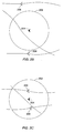
- a vehicle positioning algorithm uses an error region 202 around a dead-reckoned position 204 to generate position possibilities 206
- the differing levels of database accuracy make the selection of the size of error region 202 problematic.
- the size of error region 202 is chosen with reference to an urban downtown area (Fig. 2a)
- the size of error region 202 is chosen with reference to a hilly area (Fig. 2c)
- a vehicle navigation system which distinguishes between different types of regions in its map database, and adjusts the parameters related to its navigation algorithms accordingly to provide for more accurate and efficient vehicle navigation.
- the present invention provides a vehicle navigation system which is capable of recognizing the characteristics of a geographical region in which a navigation algorithm is operating, and, in response, altering the parameters related to the navigation algorithm so that it operates more efficiently in that region. For example, when the vehicle navigation system of the present invention recognizes that its maneuver generation algorithm is operating in a sparsely digitized region of the map database, it will provide maneuver instructions for selected nodes to which it is likely roads are connected that are not represented in the database. Likewise, in fully digitized areas, the maneuver generation algorithm will assume that no connecting roads exist where none are indicated, thus avoiding the communication of unnecessary maneuvers to the user. Essentially, this feature of the present invention has the effect of providing extra guidance in hilly or rural areas while eliminating extraneous maneuver instructions in urban areas.
- the vehicle navigation system of the present invention when the vehicle navigation system of the present invention recognizes that its vehicle positioning algorithm is operating in an urban grid pattern area, it adjusts the size of the search region employed to identify position possibilities to correspond to the denser and more regular layout of the region. Similarly, in a non-grid pattern area, the system employs a larger search region than the search region employed in a grid pattern area.
- a vehicle navigation system in which the map database stores information representative of a plurality of geographical region types.
- the system determines the type of geographical region in which a navigation algorithm is operating, sets at least one parameter related to the navigation algorithm to correspond to that geographical region type, and performs navigation with the algorithm.
- the system determines whether the geographical region type in which the algorithm is operating has changed, and, if the algorithm is operating in a different type of region, changes the appropriate parameters related to the algorithm to correspond to the different geographical region type. This process is repeated throughout the operation of the navigation algorithm.
- the system recognizes and distinguishes between fully and sparsely digitized regions in the map database. In another embodiment, the system recognizes and distinguishes between grid pattern regions and non-grid pattern regions. The characteristics of these region types are discussed below.
- the navigation algorithm comprises a route determination algorithm, a maneuver generation algorithm, or a vehicle positioning algorithm.
- the present invention relates generally to commonly assigned United States Patents No. 5,345,382 to Kao for CALIBRATION METHOD FOR A RELATIVE HEADING SENSOR, and No. 5,359,529 to Snider for ROUTE GUIDANCE ON/OFF-ROUTE STATE FILTER, and commonly assigned, copending United States patent applications for POSITION CORRECTION METHOD FOR VEHICLE NAVIGATION SYSTEM, Serial No. 08/000,950 filed on January 5, 1993, METHOD FOR SELECTING A DESTINATION IN A VEHICLE NAVIGATION SYSTEM, Serial No.
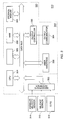
- Fig. 3 is a block diagram of a specific embodiment of a vehicle navigation system 310 for use with the present invention.
- Sensors 312 and 314 and GPS receiver 318 are coupled to computing means 320 through sensor/GPS interface 322.
- mileage sensor 312 comprises an odometer
- angular velocity sensor 314 comprises a gyroscope, or a differential odometer coupled to the wheels of the vehicle.
- a global positioning system (GPS) data receiver 318 is provided for receiving signals from, for example, a satellite-based navigation system. Data from sensor/GPS interface 322 is transmitted to CPU 324, which performs calibration, signal processing, dead-reckoning, vehicle positioning, and route guidance functions.
- GPS global positioning system
- a database containing map information may be stored in database medium 326, with software directing the operation of computing means 320 stored in main memory 328 for execution by CPU 324.
- Memory 328 may comprise read-only memory (ROM), or reprogrammable non-volatile memory such as flash memory or SRAM.
- System RAM 330 permits reading and writing of the information necessary to execute such software programs.
- Database medium 326 may comprise non-volatile memory, a hard disk drive, CD-ROM, or an integrated circuit in which digitized map information has been stored.
- Output controller 332 which may comprise a graphics controller, receives data processed by CPU 324 and transmits the data to display console 340 which includes output communicator 334, usually comprising a display screen.
- the user may input data, such as a desired destination, through user interface 336, typically comprising a keyboard.
- the map database stored in database medium 326 preferably comprises positional data such as, for example, latitude and longitude coordinates, to describe road intersections or nodes, road segments, landmarks and points of interest, and other geographical information.
- the data base may further comprise data representing characteristics of roads or places on the map, such as road and place names, road features such as dividers, one-way restrictions, surface, speed limit, shape, elevation, and other properties.
- the map database includes cost values associated with individual nodes and road segments. These cost values correspond to the estimates of time intervals for traversing the respective node or segment. Node cost values take into consideration such information as, for example, whether the vehicle would encounter oncoming traffic, thus delaying a left turn maneuver.
- Segment costs reflect road segment characteristics such as speed limit and segment length, both of which affect the travel time along the segment.
- a hierarchy value which relates to the category or type of the road. For example, the highest level category of the hierarchy includes freeways and expressways. The lowest level includes residential streets and/or alleys.
- Specific embodiments of the present invention look at various of these database characteristics to determine in which type of region a current navigation algorithm is operating. For example, the system may measure the road density for a given area by counting the number of roads within the given area and thereby distinguish between fully and sparsely digitized regions. Another way of determining whether a region is fully or sparsely digitized involves looking at the categories of the roads in the region. If, for example, a region contains mostly or only highways, then it may be designated a sparsely digitized region. If, for example, there are no streets connected to entrance and exit ramps of a highway, or the streets which are connected are very short, the region through which the highway is running is likely a sparsely digitized one.
- database characteristics may also be used to determine whether or not a region is a grid pattern region.
- the road density may be measured in a given area because grid pattern regions generally have significantly higher density than non-grid pattern regions.
- road segment lengths between intersections or junctions in the region may be measured, the ratio of the number of cross roads per unit distance being another indication of the road density in the region.
- the system may also look at the angles at which selected roads are intersected by cross roads, the roads in grid pattern regions tending to lie at substantially right angles to each other.
- Another database characteristic which is helpful in determining whether or not a region is a grid pattern region is referred to as a shape point.
- a shape point is a coordinate in a road which corresponds to a bend in the road.
- Still further embodiments of the invention include explicit information stored in the map database regarding the characteristics of particular geographic regions. For example, regions such as urban areas are designated fully digitized while rural or "inter-town" areas are designated sparsely digitized. In other embodiment, areas in which streets are laid out in a regular grid-like pattern, such as a downtown urban area, are designated as grid pattern regions while hilly or rural areas in which the streets are irregularly laid out are designated non-grid pattern areas. As will be discussed, these designations have certain consequences with regard to the operation of various navigation algorithms. Because the database in these embodiments includes this information, the system does not need to determine in which type of region the navigation algorithm is operating in the manner described above. Rather, the determination may be made merely by looking at the area type designation.
- the effectiveness of a navigation algorithm employed by a vehicle navigation system may vary depending upon the type of geographic region in which the algorithm is operating.
- the vehicle navigation system of the present invention determines the type of geographic region in which its navigation algorithms are operating and adjusts various parameters to, in effect, improve the performance of the algorithms in that region. Specific examples of this are discussed below.
- the maneuver generation algorithm employed by a specific embodiment of the invention generates a series of maneuver instructions based on a calculated route which are then communicated to the user.
- the algorithm operates with varying levels of effectiveness depending upon whether it is operating in a fully or sparsely digitized region. Referring back to Fig. 1, the maneuver generation algorithm first determines whether it is operating in a fully or sparsely digitized region of the map database. If operating in a sparsely digitized region, the algorithm will assume that there are non-represented roads connected to point A and generate a maneuver which instructs the user to negotiate the intersection appropriately. If, however, the algorithm is operating in a fully digitized region, it will assume that no non-represented roads are connected to point A if no such roads are represented in the database.
- the algorithm will not generate a maneuver corresponding to point A.
- the maneuver generation algorithm is able to change the level of detail of the maneuvers to be communicated to the user.
- the maneuver generation algorithm is manipulated so that additional maneuvers are provided in sparsely digitized regions while unnecessary maneuvers are eliminated in fully digitized regions.
- the system simply includes these additional maneuvers in regions in which the proportion of segments above a certain link class level exceeds a some fixed value.
- Link class refers to the type of road (e.g., freeway, highway, expressway, major street, etc.), with the larger road types being of higher link classes.
- the maneuver generation algorithm is manipulated with respect to whether the vehicle is determined to be operating in a grid pattern region or a non-grid pattern region. Referring to the intersection shown in Fig. 4a, if the route is as shown by the arrow, the maneuver generation algorithm must determine whether a maneuver should be generated to alert the user to the geometry of the intersection (i.e., that the Y-street bears left after crossing X-street). Whether or not a maneuver should be generated depends, in large part, on the nature of detail area 370. In a grid-pattern region (e.g., a downtown area), the road casements 372 in detail area 370 are likely to be angular as shown in Fig. 4b.
- a grid-pattern region e.g., a downtown area
- the maneuver generation algorithm would generalize such an intersection to a simple four-way junction with angular casements and would not generate a maneuver.
- the road casements are likely to be configured in any of a wide variety of geometries such as, for example, the rounded casements 374 of Fig. 4c. With such geometries, it may not be clear to the user as she approaches an intersection upon which road she should continue. Therefore, in non-grid pattern regions, the maneuver generation algorithm would not generalize the intersection geometry and would instead generate a maneuver which would alert the user to the particular geometry of the intersection and the proper road segment upon which to proceed. For example, the system could alert the user to "REMAIN ON Y-STREET, BEARING LEFT AFTER CROSSING X-STREET.”
- the vehicle positioning algorithm employed by another specific embodiment of the invention repeatedly positions the vehicle with respect to the map database to compensate for the accumulated position error due to system sensor inaccuracy.
- the algorithm generates position possibilities within a search area around the vehicle's dead reckoned position and adjusts the size of this search area to correspond to the type of area in which the algorithm is operating. Referring back to Figs. 2a-d, when it is determined that the vehicle positioning algorithm is operating in an urban area, i.e., a fully digitized region or a grid pattern region, a smaller error region 202 is employed as shown in Fig. 2a.
- a larger region 202 is employed as shown in Fig. 2c.
- the search or error region employed by the system's vehicle positioning algorithm is manipulated to correspond to the characteristics of the specific map database region, thereby providing the algorithm with a sufficient number of vehicle position possibilities for accurate vehicle positioning.
- the vehicle positioning algorithm distinguishes between grid pattern regions having different road densities, regions with densities higher than a certain level being referred to as downtown grid pattern regions. In such regions, an even smaller search or error region may be employed.
- the vehicle positioning algorithm employs a global positioning satellite (GPS) signal for determining the vehicle's absolute position in sparsely digitized or non-grid pattern regions, increasing the possible GPS multipath error region in fully digitized or grid pattern regions. This is due to the fact that urban areas generally have many high buildings and overpasses which make reception of the GPS signal unreliable.
- GPS global positioning satellite
- the route determination algorithm employed by another specific embodiment of the invention determines a route from the vehicle's current location to a destination input by the user.
- the system adjusts the values of segment and node costs when determining the route depending upon the type of region in which the segment or node resides. If, for example, a node is in a fully digitized region or a grid pattern region, the algorithm might adjust the node cost upward given that a left turn at a downtown intersection generally takes longer than a left turn in a rural area. Similarly, a segment cost in a fully digitized region or a grid pattern region may be upwardly adjusted given that traffic is generally heavier in urban areas. Conversely, node and segment costs in sparsely digitized regions or non-grid pattern regions may be downwardly adjusted to correspond to the characteristics of these types of regions.
- Fig. 5 is a flowchart 400 which describes the operation of a specific embodiment of the invention.
- the system determines in which type of geographical region a navigation algorithm (e.g., route determination, maneuver generation, or vehicle positioning) is currently operating (step 402).
- this includes an analysis of at least one database characteristic, such as road density, in the current geographical region.
- the system sets at least one parameter related to the navigation algorithm to correspond to the geographical region type (step 404).
- the system then navigates using the navigation algorithm (step 406). This might include, for example, at least one determination of the vehicle's position, or determination of a portion of a route to a final destination.
- step 408 the system determines whether the current geographical region has changed to a different geographical region type (step 410). If a different region type is determined, the system changes the appropriate parameters to correspond to the different geographical region type (step 412). If the region type has not changed, the algorithm continues to operate using the same parameters. These steps are repeated while the navigation algorithm is operating. In general, for the route determination algorithm, this is when the route to the desired destination has been determined; for the maneuver generation algorithm, this is when all maneuvers have been determined; and for the vehicle positioning algorithm, this is when the system is not in use.
- region classifications are employed by different embodiments of the present invention. These include, but are not limited to, urban/suburban vs. rural, windy vs. straight, hilly vs. flat, angular road casements vs. rounded road casements. In various embodiments of the invention (where the region classification is not included in the map database), these classifications are determined according to a variety of criteria.
- windy road regions may be determined by counting the number of shape points in the road segments in the region. This information may also be employed with other information to determine other region classifications. For example, shape point per segment counts may be employed along with information regarding the density with which a region is digitized to determine whether a region is urban/suburban or rural. In addition, shape point counts, in conjunction with information regarding intersection angles, may be employed to determine whether a region is a grid pattern or non-grid pattern region. Shape point counts may also be employed with altitude change information to determine whether a region is likely to have angular or rounded road casements. It will be understood that the factors which may be employed to determine region classification are numerous and are not limited to those described above.
- Each region classification scheme is related to and affects the operation of one or more navigation algorithms.
- the urban/suburban vs. rural classification scheme affects any navigation algorithms which make use of GPS (e.g., a vehicle positioning algorithm). This is due to the fact that GPS reception is unreliable in downtown urban areas. Therefore, when the system recognizes that it is operating in an urban area, GPS is either not used or reliance on GPS is reduced. Fortunately, map matching techniques for vehicle positioning are more accurate in urban than in rural areas and may be used instead. Two-dimensional GPS data also are not used in hilly regions as opposed to flat regions. This is due to the fact that the two-dimensional GPS data are inaccurate in regions which exhibit altitude changes.
- the vehicle positioning algorithm employed by various embodiments of the invention is affected by both the windy vs. straight and the hilly vs. flat region classifications. In regions with windy as opposed to straight roads, map matching is difficult, therefore, the vehicle positioning algorithm may depend more on other positioning techniques such as GPS in these regions. In hilly regions, segment lengths stored in the map database are not as accurate as for flat regions. Therefore, in hilly regions, positioning techniques which employ odometer readings (e.g., map matching) would rely more heavily on other positioning techniques.
- the maneuver generation algorithm of the present invention is affected by the windy vs. straight and the angular vs. rounded road casement classifications.
- the number of maneuvers generated is increased because of unusual and potentially confusing road and intersection geometries encountered by the user of the system.
- the effect on maneuver generation is the same as described above with reference to Figs. 4a-c.
- shorter distance and time intervals are employed between successive alerts to the user about upcoming maneuvers than in sparsely digitized regions.
- the segment costs assigned to road segments are upwardly adjusted for regions with windy roads in comparison to regions with straight roads. This allows the route calculation to take increased travel time into account when determining the best route to a particular destination.
Landscapes
- Engineering & Computer Science (AREA)
- Radar, Positioning & Navigation (AREA)
- Remote Sensing (AREA)
- Automation & Control Theory (AREA)
- Physics & Mathematics (AREA)
- General Physics & Mathematics (AREA)
- Navigation (AREA)
- Traffic Control Systems (AREA)
- Instructional Devices (AREA)
- Processing Or Creating Images (AREA)
Applications Claiming Priority (2)
| Application Number | Priority Date | Filing Date | Title |
|---|---|---|---|
| US08/480,759 US5731978A (en) | 1995-06-07 | 1995-06-07 | Method and apparatus for enhancing vehicle navigation through recognition of geographical region types |
| US480759 | 1995-06-07 |
Publications (2)
| Publication Number | Publication Date |
|---|---|
| EP0747671A2 true EP0747671A2 (fr) | 1996-12-11 |
| EP0747671A3 EP0747671A3 (fr) | 1999-02-10 |
Family
ID=23909251
Family Applications (1)
| Application Number | Title | Priority Date | Filing Date |
|---|---|---|---|
| EP96302380A Withdrawn EP0747671A3 (fr) | 1995-06-07 | 1996-04-03 | Reconnaissance de types de régions géographiques dans une base de données de cartes |
Country Status (4)
| Country | Link |
|---|---|
| US (1) | US5731978A (fr) |
| EP (1) | EP0747671A3 (fr) |
| JP (1) | JPH08335033A (fr) |
| CA (1) | CA2169707C (fr) |
Cited By (10)
| Publication number | Priority date | Publication date | Assignee | Title |
|---|---|---|---|---|
| DE19802595A1 (de) * | 1998-01-23 | 1999-07-29 | Volkswagen Ag | Kraftfahrzeug mit einem Navigationssystem |
| EP0854353A3 (fr) * | 1997-01-15 | 2000-04-26 | Visteon Technologies, LLC | Détermination de routes dans un système de navigation véhiculaire |
| FR2876819A1 (fr) * | 2004-10-18 | 2006-04-21 | Michelin Soc Tech | Procede de determination d'un itineraire en fonction de l'indice de sinuosite. |
| WO2006042689A1 (fr) * | 2004-10-18 | 2006-04-27 | Societe De Technologie Michelin | Procede d’etablissement d’un indice de sinuosite pour systeme de cartographie numerique |
| DE19836155B4 (de) * | 1997-08-08 | 2007-05-16 | Aisin Aw Co | Fahrzeugnavigationssystem und Speichermedium |
| WO2007139495A1 (fr) * | 2006-05-26 | 2007-12-06 | Scania Cv Ab (Publ) | Dispositif et système de classification d'environnement de véhicule |
| WO2009059574A1 (fr) * | 2007-11-07 | 2009-05-14 | Navigon Ag | Procédé d'utilisation d'un système de navigation |
| US7680859B2 (en) * | 2001-12-21 | 2010-03-16 | Location Inc. Group Corporation a Massachusetts corporation | Method for analyzing demographic data |
| WO2011116265A3 (fr) * | 2010-03-18 | 2012-01-19 | Harman International Industries, Incorporated | Système de navigation routière |
| WO2012089279A1 (fr) * | 2010-12-31 | 2012-07-05 | Tomtom International B.V. | Facteur de pondération non uniforme utilisé dans un algorithme d'établissement d'itinéraire |
Families Citing this family (53)
| Publication number | Priority date | Publication date | Assignee | Title |
|---|---|---|---|---|
| TW317643B (fr) * | 1996-02-23 | 1997-10-11 | Handotai Energy Kenkyusho Kk | |
| EP0798540B1 (fr) * | 1996-03-25 | 2001-08-22 | MANNESMANN Aktiengesellschaft | Méthode pour référencer des objets localisés |
| KR100189536B1 (ko) * | 1996-08-08 | 1999-06-01 | 윤종용 | 전세계 위성측위 시스템을 이용한 네비게이션장치의 이동체 위치 표시 장치_ |
| US5878368A (en) * | 1996-09-13 | 1999-03-02 | Magellan Dis, Inc. | Navigation system with user definable cost values |
| US7197500B1 (en) * | 1996-10-25 | 2007-03-27 | Navteq North America, Llc | System and method for use and storage of geographic data on physical media |
| US6047280A (en) | 1996-10-25 | 2000-04-04 | Navigation Technologies Corporation | Interface layer for navigation system |
| JP3384263B2 (ja) * | 1996-11-20 | 2003-03-10 | 日産自動車株式会社 | 車両用ナビゲーション装置 |
| US5832493A (en) * | 1997-04-24 | 1998-11-03 | Trimble Navigation Limited | Flash file management system |
| JP3500928B2 (ja) * | 1997-09-17 | 2004-02-23 | トヨタ自動車株式会社 | 地図データ処理装置、地図データ処理方法および地図データ処理システム |
| US6047234A (en) * | 1997-10-16 | 2000-04-04 | Navigation Technologies Corporation | System and method for updating, enhancing or refining a geographic database using feedback |
| US6381533B1 (en) | 1997-10-16 | 2002-04-30 | Navigation Technologies Corp. | Method and system using positions of cellular phones matched to road network for collecting data |
| JP3509511B2 (ja) * | 1997-11-20 | 2004-03-22 | トヨタ自動車株式会社 | 車両用情報取得装置 |
| US7266560B2 (en) * | 1998-01-30 | 2007-09-04 | Navteq North America, Llc | Parcelized geographic data medium with internal spatial indices and method and system for use and formation thereof |
| FR2775520B1 (fr) * | 1998-02-27 | 2000-05-26 | Mlr Electronique | Procede d'enregistrement dans une memoire notamment d'un systeme de navigation et de positionnement de donnees geographiques et agencement pour la mise en oeuvre de ce procede |
| US6202024B1 (en) * | 1998-03-23 | 2001-03-13 | Kabushikikaisha Equos Research | Communicatory navigation system |
| DE19847849A1 (de) * | 1998-10-16 | 2000-04-27 | Nokia Mobile Phones Ltd | Verfahren und Vorrichtung zur Selektion von Verkehrsinformation für ein Kraftfahrzeug |
| US6188957B1 (en) | 1999-10-04 | 2001-02-13 | Navigation Technologies Corporation | Method and system for providing bicycle information with a navigation system |
| DE19950156C5 (de) * | 1999-10-19 | 2010-03-04 | Robert Bosch Gmbh | Verfahren zur automatischen Anpassung der Anzeige eines Kombiinstruments |
| JP2003523565A (ja) * | 1999-12-29 | 2003-08-05 | グローリキアン,ハリー・エイ | クライアントの旅行者を地理的に関連するデータに接続するインターネットシステム |
| US6430501B1 (en) | 2000-01-19 | 2002-08-06 | Magellan Dis, Inc. | Navigation system with route indicators |
| US6510382B2 (en) * | 2000-01-26 | 2003-01-21 | Daimlerchrysler Ag | Method for obtaining precision road maps |
| US6587787B1 (en) * | 2000-03-15 | 2003-07-01 | Alpine Electronics, Inc. | Vehicle navigation system apparatus and method providing enhanced information regarding geographic entities |
| US6381537B1 (en) | 2000-06-02 | 2002-04-30 | Navigation Technologies Corp. | Method and system for obtaining geographic data using navigation systems |
| DE10035626C2 (de) * | 2000-07-21 | 2002-06-13 | Siemens Ag | Navigationsgerät und Verfahren zur Positionskorrektur |
| US6725152B2 (en) | 2002-02-21 | 2004-04-20 | Lockheed Martin Corporation | Real-time route and sensor planning system with variable mission objectives |
| US6718261B2 (en) | 2002-02-21 | 2004-04-06 | Lockheed Martin Corporation | Architecture for real-time maintenance of distributed mission plans |
| US6687606B1 (en) | 2002-02-21 | 2004-02-03 | Lockheed Martin Corporation | Architecture for automatic evaluation of team reconnaissance and surveillance plans |
| US7647232B2 (en) | 2002-02-21 | 2010-01-12 | Lockheed Martin Corporation | Real-time team coordination system for reconnaissance and surveillance missions |
| US7221287B2 (en) | 2002-03-05 | 2007-05-22 | Triangle Software Llc | Three-dimensional traffic report |
| WO2005013063A2 (fr) | 2003-07-25 | 2005-02-10 | Landsonar, Inc. | Systeme et procede pour determiner une heure de depart recommandee |
| US7376510B1 (en) * | 2004-11-05 | 2008-05-20 | Navteq North America, Llc | Map display for a navigation system |
| US8370054B2 (en) * | 2005-03-24 | 2013-02-05 | Google Inc. | User location driven identification of service vehicles |
| US7642958B2 (en) | 2005-06-21 | 2010-01-05 | Motorola, Inc. | Satellite positioning system receivers and methods |
| JP4710740B2 (ja) * | 2006-07-04 | 2011-06-29 | 株式会社デンソー | 位置情報利用装置 |
| US8692710B2 (en) * | 2006-08-31 | 2014-04-08 | Sige Semiconductor (Europe) Limited | Apparatus and method for use in global positioning measurements |
| US8554475B2 (en) | 2007-10-01 | 2013-10-08 | Mitac International Corporation | Static and dynamic contours |
| JP5030063B2 (ja) * | 2007-10-05 | 2012-09-19 | 本田技研工業株式会社 | ナビゲーション装置およびナビゲーションシステム |
| US8825683B2 (en) | 2007-11-26 | 2014-09-02 | Urban Mapping, Inc. | Generating geographical keywords for geotargeting search engine-offered advertisements |
| GB0822893D0 (en) * | 2008-12-16 | 2009-01-21 | Tele Atlas Bv | Advanced speed profiles - Further updates |
| US9046924B2 (en) * | 2009-03-04 | 2015-06-02 | Pelmorex Canada Inc. | Gesture based interaction with traffic data |
| US8619072B2 (en) * | 2009-03-04 | 2013-12-31 | Triangle Software Llc | Controlling a three-dimensional virtual broadcast presentation |
| US8982116B2 (en) * | 2009-03-04 | 2015-03-17 | Pelmorex Canada Inc. | Touch screen based interaction with traffic data |
| US20110241935A1 (en) * | 2009-03-23 | 2011-10-06 | Srdjan Miocinovic | Method and apparatus for improving gps receiver accuracy using an embedded map database |
| US8442763B2 (en) | 2010-04-16 | 2013-05-14 | CSR Technology Holdings Inc. | Method and apparatus for geographically aiding navigation satellite system solution |
| US8718910B2 (en) | 2010-11-14 | 2014-05-06 | Pelmorex Canada Inc. | Crowd sourced traffic reporting |
| WO2012159083A2 (fr) | 2011-05-18 | 2012-11-22 | Triangle Software Llc | Système permettant d'utiliser des données de trafic et des données d'efficacité de conduite |
| US8736487B2 (en) | 2011-09-21 | 2014-05-27 | Csr Technology Inc. | Method and apparatus of using height aiding from a contour table for GNSS positioning |
| CA2883973C (fr) | 2012-01-27 | 2021-02-23 | Edgar Rojas | Estimation des distributions temporelles de parcours sur des arteres signalisees |
| US9453734B2 (en) * | 2012-06-05 | 2016-09-27 | Apple Inc. | Smart loading of map tiles |
| US10223909B2 (en) | 2012-10-18 | 2019-03-05 | Uber Technologies, Inc. | Estimating time travel distributions on signalized arterials |
| US10072937B2 (en) | 2016-07-14 | 2018-09-11 | Here Global B.V. | Map having computer executable instructions embedded therein |
| JP6647172B2 (ja) * | 2016-08-05 | 2020-02-14 | 株式会社日立製作所 | 経路同定装置、経路同定システム及び経路同定方法 |
| CN113447034B (zh) * | 2021-06-30 | 2024-09-24 | 北京百度网讯科技有限公司 | 一种路网数据处理方法、装置、电子设备及可读存储介质 |
Family Cites Families (37)
| Publication number | Priority date | Publication date | Assignee | Title |
|---|---|---|---|---|
| US3845289A (en) * | 1972-07-18 | 1974-10-29 | Avon Inc | Method and apparatus employing automatic route control system |
| US4672565A (en) * | 1981-03-10 | 1987-06-09 | Nippon Soken, Inc. | Direction detecting system for vehicles |
| JPS57169785A (en) * | 1981-04-13 | 1982-10-19 | Nissan Motor | Travelling guidance system for car |
| EP0066397B2 (fr) * | 1981-05-15 | 1992-08-05 | Nippondenso Co., Ltd. | Dispositif de navigation pour utiliser dans des véhicules à moteur |
| JPH0619276B2 (ja) * | 1981-08-17 | 1994-03-16 | 工業技術院長 | 携帯地図表示装置組体 |
| JPS58151513A (ja) * | 1982-03-05 | 1983-09-08 | Alps Electric Co Ltd | 移動体の現在位置更新表示装置 |
| US4611293A (en) * | 1983-11-28 | 1986-09-09 | Magnavox Government And Industrial Electronics Company | Method and apparatus for automatic calibration of magnetic compass |
| US4797841A (en) * | 1983-11-28 | 1989-01-10 | Magnavox Government And Industrial Electronics Company | Method and apparatus for automatic calibration of magnetic compass |
| US4796191A (en) * | 1984-06-07 | 1989-01-03 | Etak, Inc. | Vehicle navigational system and method |
| US4914605A (en) * | 1984-10-22 | 1990-04-03 | Etak, Inc. | Apparatus and method for displaying a map |
| US4734863A (en) * | 1985-03-06 | 1988-03-29 | Etak, Inc. | Apparatus for generating a heading signal for a land vehicle |
| JPH0650559B2 (ja) * | 1985-04-03 | 1994-06-29 | 日産自動車株式会社 | 車両用経路誘導装置 |
| US4751512A (en) * | 1986-01-21 | 1988-06-14 | Oceanonics, Inc. | Differential navigation system for remote mobile users |
| DE3626610A1 (de) * | 1986-08-06 | 1988-02-18 | Fibro Gmbh | Portalsystem |
| US4862398A (en) * | 1986-11-18 | 1989-08-29 | Sumitomo Electric Industries, Ltd. | Correcting method and correcting errors in a terrestrial magnetism heading sensor |
| DE3715007A1 (de) * | 1987-05-06 | 1988-11-17 | Bosch Gmbh Robert | Verfahren und vorrichtung zur kursbestimmung eines landfahrzeugs |
| US4999783A (en) * | 1987-05-11 | 1991-03-12 | Sumitomo Electric Industries, Ltd. | Location detecting method |
| DE3719017A1 (de) * | 1987-06-06 | 1988-12-15 | Bosch Gmbh Robert | Verfahren und vorrichtung zur bestimmung einer fahrtroute zwischen einem startpunkt und einem zielpunkt |
| NL8702087A (nl) * | 1987-09-04 | 1989-04-03 | Philips Nv | Voertuignavigatie-inrichting met weergave van een geselekteerd kaartelement volgens een voorafbepaalde representatienorm. |
| US4972319A (en) * | 1987-09-25 | 1990-11-20 | Delorme David M | Electronic global map generating system |
| US4964052A (en) * | 1987-10-30 | 1990-10-16 | Nec Home Electronics Ltd. | Navigation device for use in a vehicle |
| JPH01173824A (ja) * | 1987-12-28 | 1989-07-10 | Aisin Aw Co Ltd | ヘルプ機能を備えた車両用ナビゲーション装置 |
| JP2637446B2 (ja) * | 1987-12-28 | 1997-08-06 | アイシン・エィ・ダブリュ株式会社 | ナビゲーション装置 |
| JP2680318B2 (ja) * | 1987-12-28 | 1997-11-19 | アイシン・エィ・ダブリュ株式会社 | ナビゲーション装置 |
| JPH01214711A (ja) * | 1988-02-23 | 1989-08-29 | Toshiba Corp | ナビゲーション装置 |
| JPH023900A (ja) * | 1988-06-16 | 1990-01-09 | Nissan Motor Co Ltd | 移動体用現在地表示装置 |
| JPH07117420B2 (ja) * | 1988-06-27 | 1995-12-18 | パイオニア株式会社 | 車載ナビゲーション装置における道路データ生成方法 |
| JPH07119617B2 (ja) * | 1988-07-05 | 1995-12-20 | マツダ株式会社 | 車両用ナビゲーシヨン装置 |
| US4918609A (en) * | 1988-10-11 | 1990-04-17 | Koji Yamawaki | Satellite-based position-determining system |
| US5060162A (en) * | 1988-12-09 | 1991-10-22 | Matsushita Electric Industrial Co., Ltd. | Vehicle in-situ locating apparatus |
| US5036471A (en) * | 1989-04-18 | 1991-07-30 | Sanyo Electric Co., Ltd. | Apparatus for road path searching applicable to car navigation system and operation method thereof |
| US5287297A (en) * | 1989-11-02 | 1994-02-15 | Matsushita Electric Industrial Co., Ltd. | Magnetic direction finder with correcting circuit |
| US5177685A (en) * | 1990-08-09 | 1993-01-05 | Massachusetts Institute Of Technology | Automobile navigation system using real time spoken driving instructions |
| EP0485132B1 (fr) * | 1990-11-06 | 1996-03-06 | Fujitsu Ten Limited | Capteur de direction avec un capteur du magnétisme terrestre et un capteur gyroscopique du vitesse de rotation et système de navigation qui contient ce capteur de direction |
| JPH04315913A (ja) * | 1991-04-16 | 1992-11-06 | Pioneer Electron Corp | 車両方位測定装置 |
| JP2673403B2 (ja) * | 1992-06-23 | 1997-11-05 | 本田技研工業株式会社 | 経路探索装置 |
| US5428546A (en) * | 1992-10-16 | 1995-06-27 | Mobile Information Systems | Method and apparatus for tracking vehicle location |
-
1995
- 1995-06-07 US US08/480,759 patent/US5731978A/en not_active Expired - Lifetime
-
1996
- 1996-02-16 CA CA002169707A patent/CA2169707C/fr not_active Expired - Lifetime
- 1996-04-03 EP EP96302380A patent/EP0747671A3/fr not_active Withdrawn
- 1996-04-25 JP JP8105283A patent/JPH08335033A/ja active Pending
Cited By (17)
| Publication number | Priority date | Publication date | Assignee | Title |
|---|---|---|---|---|
| EP0854353A3 (fr) * | 1997-01-15 | 2000-04-26 | Visteon Technologies, LLC | Détermination de routes dans un système de navigation véhiculaire |
| DE19836155B4 (de) * | 1997-08-08 | 2007-05-16 | Aisin Aw Co | Fahrzeugnavigationssystem und Speichermedium |
| US6040766A (en) * | 1998-01-23 | 2000-03-21 | Volkswagen Ag | Motor vehicle navigation system arrangement |
| DE19802595A1 (de) * | 1998-01-23 | 1999-07-29 | Volkswagen Ag | Kraftfahrzeug mit einem Navigationssystem |
| US8849808B2 (en) | 2001-12-21 | 2014-09-30 | Location Inc. Group Corporation | Method for analyzing demographic data |
| US7680859B2 (en) * | 2001-12-21 | 2010-03-16 | Location Inc. Group Corporation a Massachusetts corporation | Method for analyzing demographic data |
| FR2876819A1 (fr) * | 2004-10-18 | 2006-04-21 | Michelin Soc Tech | Procede de determination d'un itineraire en fonction de l'indice de sinuosite. |
| WO2006042689A1 (fr) * | 2004-10-18 | 2006-04-27 | Societe De Technologie Michelin | Procede d’etablissement d’un indice de sinuosite pour systeme de cartographie numerique |
| WO2006042690A3 (fr) * | 2004-10-18 | 2007-01-11 | Michelin Soc Tech | Procede de determination d’un itineraire en fonction de l’indice de sinuosite |
| WO2007139495A1 (fr) * | 2006-05-26 | 2007-12-06 | Scania Cv Ab (Publ) | Dispositif et système de classification d'environnement de véhicule |
| RU2423665C2 (ru) * | 2006-05-26 | 2011-07-10 | СКАНИА СВ АБ (пабл) | Устройство и система для классификации окружающей среды транспортного средства |
| CN101495835B (zh) * | 2006-05-26 | 2014-11-05 | 斯堪尼亚有限公司 | 对车辆周围环境进行分类的装置和系统 |
| WO2009059574A1 (fr) * | 2007-11-07 | 2009-05-14 | Navigon Ag | Procédé d'utilisation d'un système de navigation |
| US8285485B2 (en) | 2010-03-18 | 2012-10-09 | Harman International Industries, Incorporated | Vehicle navigation system with route determination based on a measure of sportiness |
| WO2011116265A3 (fr) * | 2010-03-18 | 2012-01-19 | Harman International Industries, Incorporated | Système de navigation routière |
| WO2012089279A1 (fr) * | 2010-12-31 | 2012-07-05 | Tomtom International B.V. | Facteur de pondération non uniforme utilisé dans un algorithme d'établissement d'itinéraire |
| US11009363B2 (en) | 2010-12-31 | 2021-05-18 | Tomtom Navigation B.V. | Non-uniform weighting factor as route algorithm input |
Also Published As
| Publication number | Publication date |
|---|---|
| JPH08335033A (ja) | 1996-12-17 |
| CA2169707C (fr) | 1999-05-11 |
| CA2169707A1 (fr) | 1996-12-08 |
| EP0747671A3 (fr) | 1999-02-10 |
| US5731978A (en) | 1998-03-24 |
Similar Documents
| Publication | Publication Date | Title |
|---|---|---|
| US5731978A (en) | Method and apparatus for enhancing vehicle navigation through recognition of geographical region types | |
| US7734410B2 (en) | Navigation system | |
| US5712788A (en) | Incremental route calculation | |
| EP0901001B1 (fr) | Méthode et dispositif pour afficher la position actuelle d'un véhicule | |
| US5904728A (en) | Voice guidance timing in a vehicle navigation system | |
| EP0846933B1 (fr) | Système de navigation véhiculaire | |
| EP0689034B1 (fr) | Méthode d'identification des bretelles d'accès d'autoroute servant au calcul de route dans un système de navigation véhiculaire | |
| US6456931B1 (en) | Indicating directions to destination and intermediate locations in vehicle navigation systems | |
| US6173232B1 (en) | Vehicle navigation system and a recording medium | |
| EP0945707B1 (fr) | Méthode et dispositif pour calcul de route | |
| US7398155B2 (en) | Car navigation system | |
| EP0854463A2 (fr) | Méthode et appareil déterminant un itinéraire de remplacement dans un système de navigation pour véhicule | |
| ES2569936T3 (es) | Plataforma de arquitectura de datos de mapas para sistemas avanzados de ayuda al conductor | |
| EP0973011A2 (fr) | Méthode et dispositif pour fournir de l'information de route dans un système de navigation véhiculaire | |
| US6604048B2 (en) | Car navigation system and storage medium | |
| JP2544855B2 (ja) | 車両誘導装置 | |
| JP2914111B2 (ja) | 経路案内装置 | |
| JPH06331367A (ja) | 道路地図表示装置 | |
| JPH0914978A (ja) | ナビゲーション装置のマップマッチング方法、及びナビゲーション装置 | |
| JPH0755489A (ja) | 経路走行判定装置 | |
| JPH04258714A (ja) | 旅行時間計測装置および旅行時間データ処理システム | |
| JPH0749236A (ja) | 経路案内表示装置 | |
| JPH05340762A (ja) | 経路計算機能を有するナビゲーション装置 | |
| JPH0611352A (ja) | 経路計算機能を有するナビゲーション装置 |
Legal Events
| Date | Code | Title | Description |
|---|---|---|---|
| PUAI | Public reference made under article 153(3) epc to a published international application that has entered the european phase |
Free format text: ORIGINAL CODE: 0009012 |
|
| AK | Designated contracting states |
Kind code of ref document: A2 Designated state(s): DE ES FR GB IT SE |
|
| 17P | Request for examination filed |
Effective date: 19970313 |
|
| PUAL | Search report despatched |
Free format text: ORIGINAL CODE: 0009013 |
|
| AK | Designated contracting states |
Kind code of ref document: A3 Designated state(s): DE ES FR GB IT SE |
|
| RAP1 | Party data changed (applicant data changed or rights of an application transferred) |
Owner name: VISTEON TECHNOLOGIES, LLC |
|
| 17Q | First examination report despatched |
Effective date: 20010123 |
|
| STAA | Information on the status of an ep patent application or granted ep patent |
Free format text: STATUS: THE APPLICATION HAS BEEN WITHDRAWN |
|
| 18W | Application withdrawn |
Withdrawal date: 20020325 |