EP0911779A2 - Procédé et appareil de surveillance de la circulation routière sur une grande surface - Google Patents
Procédé et appareil de surveillance de la circulation routière sur une grande surface Download PDFInfo
- Publication number
- EP0911779A2 EP0911779A2 EP98115967A EP98115967A EP0911779A2 EP 0911779 A2 EP0911779 A2 EP 0911779A2 EP 98115967 A EP98115967 A EP 98115967A EP 98115967 A EP98115967 A EP 98115967A EP 0911779 A2 EP0911779 A2 EP 0911779A2
- Authority
- EP
- European Patent Office
- Prior art keywords
- traffic
- vehicles
- images
- recognized
- further characterized
- Prior art date
- Legal status (The legal status is an assumption and is not a legal conclusion. Google has not performed a legal analysis and makes no representation as to the accuracy of the status listed.)
- Withdrawn
Links
- 238000000034 method Methods 0.000 title claims abstract description 39
- 238000012544 monitoring process Methods 0.000 title claims description 20
- 230000002159 abnormal effect Effects 0.000 claims abstract description 4
- 238000012545 processing Methods 0.000 claims description 16
- 230000005855 radiation Effects 0.000 claims description 11
- 238000003384 imaging method Methods 0.000 claims description 4
- 206010039203 Road traffic accident Diseases 0.000 claims description 3
- 238000001454 recorded image Methods 0.000 claims description 2
- 238000001514 detection method Methods 0.000 description 6
- 238000011156 evaluation Methods 0.000 description 5
- 230000004807 localization Effects 0.000 description 4
- 238000012360 testing method Methods 0.000 description 4
- 230000005540 biological transmission Effects 0.000 description 2
- 238000004422 calculation algorithm Methods 0.000 description 2
- 230000000903 blocking effect Effects 0.000 description 1
- 238000004891 communication Methods 0.000 description 1
- 238000012790 confirmation Methods 0.000 description 1
- 230000001419 dependent effect Effects 0.000 description 1
- 238000013461 design Methods 0.000 description 1
- 238000011161 development Methods 0.000 description 1
- 238000010586 diagram Methods 0.000 description 1
- 230000006698 induction Effects 0.000 description 1
- 238000009434 installation Methods 0.000 description 1
- 230000007257 malfunction Effects 0.000 description 1
- 239000003305 oil spill Substances 0.000 description 1
- 238000012567 pattern recognition method Methods 0.000 description 1
Images
Classifications
-
- G—PHYSICS
- G08—SIGNALLING
- G08G—TRAFFIC CONTROL SYSTEMS
- G08G1/00—Traffic control systems for road vehicles
- G08G1/01—Detecting movement of traffic to be counted or controlled
- G08G1/04—Detecting movement of traffic to be counted or controlled using optical or ultrasonic detectors
-
- G—PHYSICS
- G08—SIGNALLING
- G08G—TRAFFIC CONTROL SYSTEMS
- G08G1/00—Traffic control systems for road vehicles
- G08G1/01—Detecting movement of traffic to be counted or controlled
- G08G1/0104—Measuring and analyzing of parameters relative to traffic conditions
Definitions
- the invention relates to a method and an apparatus for large-area traffic monitoring of one of vehicles trafficable traffic network. This can be particularly act as a road network, but is possible also the traffic situation monitoring of a rail network or one Shipping network.
- the published patent application WO 96/13733 describes a method for Ship traffic monitoring at sea with detection of oil spills and icebergs and possible collision risks between ships or between a ship and icebergs.
- This process eliminates oil spills and Icebergs on the sea surface using satellite-based SAR (Synthetic Aperture Radar) microwave sensors observed and recognized.
- SAR Synthetic Aperture Radar
- the satellites transmit the data the location and size of a detected oil spill and detected icebergs as well as those received from the ships current ship position data to an earth-fixed evaluation center.
- the evaluation center evaluates this data for identification the source of oil pollution and to identify potential Risk of collision between ships or between one Ship and icebergs and may issue a warning via the satellites to the affected ships.
- Infrastructure-based traffic monitoring systems are video cameras for traffic monitoring at traffic junctions or positioned at other critical points in the transport network.
- the pictures taken with it are from an associated one Image processing system using an appropriate one Pattern recognition method specific to the existence of the vehicle type from movements to the number of vehicles analyzed to be able to determine the type of installation for each vehicle type of the respective video camera.
- Another currently practiced method is the traffic situation data manually collected by, for example, surveillance personnel with vehicles on the road network is or with helicopters known as susceptible to failure of the traffic network and overflows Reports radio or the like to a control center.
- This method requires confirmation of malfunction reports, after which the fault message e.g. is broadcast on the radio.
- the relative With this method a long delay leads to the fact that often a announced fault no longer exists or one disturbance that has already occurred does not yet reach the road users has been announced.
- the invention is therefore a technical problem of providing a method and a device of the aforementioned Kind based on those with comparatively little Reliable large-area traffic situation monitoring can be effected.
- the invention solves this problem by providing a Method with the features of claim 1 and a device with the features of claim 7.
- the captured images are automated Image processing to localize traffic routes of the route network in the respective picture and for the detection of vehicles subjected to localized traffic routes. Based on recognized vehicle is then based on the current traffic situation closed.
- no track-side is used for this method Infrastructure and no special equipment in the Vehicles needed.
- satellites and planes with to those who take long-distance pictures of the Earth's surface can already be made known.
- Even automated Image processing techniques for the evaluation of such Images are already common.
- the image processing therefore needs only with regard to the location of the traffic routes of interest and detection of the vehicles located thereon to become what for the professional without much additional effort possible on the basis of a conventional image processing system is.
- the method can therefore be relatively inexpensive realize.
- Another advantage is the speed with which covers the traffic situation across the board, i.e. at all points in the traffic network, and at all times can be reliably determined.
- the process can be quick and simply expanded to new areas of the traffic network become.
- the traffic situation monitoring is an estimate dependent on the traffic situation the travel times between a predeterminable starting point and a predeterminable destination by the estimate based on the recognized according to the procedure and located on the traffic network Vehicles is made.
- the pure recognition of the place where there is a vehicle located on the traffic network the spatial location of the detected vehicle. From abnormal vehicle positions, e.g. from the presence of one or more transverse or upturned Vehicles, then a traffic disruption e.g. in Form of a traffic accident closed.
- the device according to claim 7 is suitable for performing the The method according to the invention, for which it uses one or more missiles with an image capturing system for capturing images the earth 's surface and for sending corresponding image data and has an, preferably earth-fixed, evaluation center.
- the evaluation center includes a suitably designed image processing system for the localization of the traffic routes of the road network and to identify the vehicles on it. Furthermore the evaluation center has the necessary conventional ones Means to based on the recognized, located on the traffic network Close vehicles to the traffic situation. On the other hand the device does not require any track-side or vehicle-side Means for traffic monitoring.
- a device developed according to claim 8 includes a Travel time estimation device in such a way that it is specifically for Carrying out the method according to claim 4 is suitable.
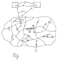
- the single figure shows a schematic block diagram of a Device for large-area traffic situation monitoring one of Vehicle traffic network.
- FIG. 1 In the figure is a fragmentary and highly schematic Part of a traffic network in the form of a road network 1 shown, which is used by vehicles 2, the Traffic situation is monitored over a large area.
- distant pictures are taken of the surface area of the earth in which the Traffic route network 1 to be monitored is located by one or preferably made of several satellites 3. Every satellite is there for that 3 equipped with a corresponding image recording system.
- the images can be, for example, by means of radar or infrared radiation or other suitable magnetic Radiation.
- the pictures of airplanes, especially airships, or other missiles are included.
- the satellites 3 are selected so that the entire area in which there are traffic routes of the traffic route network to be monitored (1), is recorded nationwide.
- the data transmission paths 5 are of a conventional type Satellite 3 with an earth-fixed evaluation center 6 in data exchange connection. Send over these data transmission links 5 the satellites 3 send the data of the recorded images to the evaluation center 6.
- the evaluation center 6 has an automated Image processing system 7, which is designed so that it the traffic routes of the to locate the monitored route network and the localized ones Vehicles can recognize traffic routes.
- image processing systems with which from distant images Such a path localization from satellites or aircraft and high-resolution detection of comparatively small ones Objects on the surface of the earth, such as vehicles, is possible are known per se and therefore do not require any further details in the present case Explanation.
- can be used to localize traffic routes of the route network in the long-distance photographs a conventional one So-called "map matching method" with superimposed vector maps be applied.
- the evaluation center 6 is thus available at the respective monitoring time about knowledge of the position practically everyone is currently on the monitored traffic network existing vehicles, which makes it able to get out of it in a conventional manner reliably to the current traffic situation close.
- the evaluation center 6 then sends corresponding Traffic situation information e.g. via radio or a radio network from those equipped with appropriate receivers Vehicles 2 received in the usual way and displayed to the driver or can be used for other purposes.
- Traffic situation information e.g. via radio or a radio network from those equipped with appropriate receivers Vehicles 2 received in the usual way and displayed to the driver or can be used for other purposes.
- Vehicles 2 received in the usual way and displayed to the driver or can be used for other purposes.
- the transmitted traffic situation information on the vehicle side existing navigation aid for route planning or route finding support.
- the traffic situation monitoring even under the most varied weather conditions to ensure, preferably at least made two sets of distant photographs, each of which Sentence covers the entire surveillance area and that on each different types of imaging radiation, such as radar radiation, Infrared radiation etc.
- the evaluation center 6 can then the distant images of that type of radiation that at provides the best picture quality in the current weather conditions, select for further evaluation.
- the evaluation center 6 preferably uses the image processing long-distance photography not just the position of everyone, vehicle located on the traffic network, but also determined its spatial location at the relevant location, i.e. the evaluation center 6 recognizes through its image processing system 7 whether the vehicle is in its normal position along the road located or standing across the road or tilted is.
- the evaluation center concludes from such abnormal vehicle positions 6 to a traffic disruption blocking traffic there, such as. a traffic accident.
- a traffic disruption blocking traffic there, such as. a traffic accident.
- the distant images are monitored by the large area of the traffic network 1 in predetermined Repeated intervals.
- a further evaluation of the Information obtained from the image processing system 7 about the Position and location of vehicles 2 on traffic network 1 executing computer unit of the evaluation center 6 is then to do so suitably designed so that it is based on the positions and locations of the individual pictures taken in succession recognized vehicles not only the origin, but also the Movement, i.e. recognizes the dynamics of a particular traffic disruption. This enables e.g. Predictions about the development of recognized Traffic jams.
- a travel time estimation device implemented in hardware or software include with the travel times of one Starting location, e.g. a location A shown in the figure, to a predeterminable Destination, e.g. a location B shown in the figure, under Based on the determined current traffic situation estimated can be. For example, in estimating travel time from the starting location A to the destination B shown the shortest route between these two locations A, B traffic jam, symbolized by the traffic jam Vehicle 2a and the vehicles 2b behind it are taken into account become. Suitable, the traffic situation between the starting point and travel time estimation algorithms taking into account destination are known per se, so that this is not the case here needs to be received.
- the process of the invention makes it clear and the device according to the invention a comprehensive traffic situation monitoring for a large area of a traffic network with quick and reliable detection of traffic disruptions and all further applications, such as travel time forecasts and navigation aid procedures.
- the special design of the image processing system with regard to Localization of traffic routes and detection of those on them Vehicles is made up of common components and processes Made use of, so that the inventive method and Device according to the invention put into practice relatively simply can be.
- Even in the case of a very large one to be monitored A single, suitably equipped evaluation center is sufficient, with the imaging satellites or Aircraft in communication connection. Other side or subordinate evaluation centers are not absolutely necessary.
Landscapes
- Physics & Mathematics (AREA)
- General Physics & Mathematics (AREA)
- Chemical & Material Sciences (AREA)
- Analytical Chemistry (AREA)
- Traffic Control Systems (AREA)
Applications Claiming Priority (2)
| Application Number | Priority Date | Filing Date | Title |
|---|---|---|---|
| DE19746570A DE19746570A1 (de) | 1997-10-22 | 1997-10-22 | Verfahren und Vorrichtung zur großflächigen Verkehrslageüberwachung |
| DE19746570 | 1997-10-22 |
Publications (2)
| Publication Number | Publication Date |
|---|---|
| EP0911779A2 true EP0911779A2 (fr) | 1999-04-28 |
| EP0911779A3 EP0911779A3 (fr) | 2000-08-09 |
Family
ID=7846237
Family Applications (1)
| Application Number | Title | Priority Date | Filing Date |
|---|---|---|---|
| EP98115967A Withdrawn EP0911779A3 (fr) | 1997-10-22 | 1998-08-25 | Procédé et appareil de surveillance de la circulation routière sur une grande surface |
Country Status (4)
| Country | Link |
|---|---|
| US (1) | US6285949B1 (fr) |
| EP (1) | EP0911779A3 (fr) |
| JP (1) | JPH11224396A (fr) |
| DE (1) | DE19746570A1 (fr) |
Cited By (7)
| Publication number | Priority date | Publication date | Assignee | Title |
|---|---|---|---|---|
| WO2000004524A3 (fr) * | 1998-07-17 | 2000-04-20 | Siemens Ag | Procede pour detecter un etat de circulation routiere de vehicules et systeme pour detecter ledit etat de circulation routiere |
| EP1022923A3 (fr) * | 1999-01-21 | 2005-09-28 | T-Mobile Deutschland GmbH | Methode d'acquisition et de traitement de donnees de trafic telematique |
| WO2007141051A1 (fr) * | 2006-06-07 | 2007-12-13 | Siemens Aktiengesellschaft | Procédé pour la mise à disposition d'informations d'environnement pour un système de navigation |
| DE102006046063A1 (de) * | 2006-09-27 | 2008-04-03 | Deutsches Zentrum für Luft- und Raumfahrt e.V. | Verfahren und System zur Erfassung von Vehikelbewegungen |
| DE102008062799A1 (de) * | 2008-12-23 | 2010-06-24 | Deutsches Zentrum für Luft- und Raumfahrt e.V. | Verfahren zur Echtzeit-Übertragung und -Verarbeitung von in einem bildaufnehmenden Sensor innerhalb eines Beobachtungsbereiches anfallenden Daten |
| EP3032454A1 (fr) | 2014-12-10 | 2016-06-15 | Honda Research Institute Europe GmbH | Procédé et système pour une analyse de scène à base de rayon adaptatif d'espaces de trafic sémantique et véhicule équipé d'un tel système |
| CN118800075A (zh) * | 2024-09-14 | 2024-10-18 | 烟台大学 | 一种基于图像数据分析处理的实时交通评估系统 |
Families Citing this family (15)
| Publication number | Priority date | Publication date | Assignee | Title |
|---|---|---|---|---|
| DE19958634A1 (de) * | 1999-12-04 | 2001-06-21 | Alcatel Sa | Verfahren zum Erkennen von Hindernissen auf Bahnstrecken |
| US6798357B1 (en) * | 2002-09-19 | 2004-09-28 | Navteq North America, Llc. | Method and system for collecting traffic information |
| US7583818B2 (en) * | 2003-05-20 | 2009-09-01 | Navteq North America, Llc | Method and system for collecting traffic information using thermal sensing |
| JP4321128B2 (ja) | 2003-06-12 | 2009-08-26 | 株式会社デンソー | 画像サーバ、画像収集装置、および画像表示端末 |
| CN101203894A (zh) * | 2005-07-11 | 2008-06-18 | 通腾科技股份有限公司 | 确定交通信息的方法和经设置以执行所述方法的装置 |
| ES2601585T3 (es) | 2009-12-18 | 2017-02-15 | Thyssenkrupp Elevator Ag | Procedimiento para el telediagnóstico de una instalación de ascensor e instalación de ascensor para la realización del procedimiento |
| DE102010020298B4 (de) | 2010-05-12 | 2012-05-16 | Deutsches Zentrum für Luft- und Raumfahrt e.V. | Verfahren und Vorrichtung zur Erfassung von Verkehrsdaten aus digitalen Luftbildsequenzen |
| US8866638B2 (en) * | 2011-05-23 | 2014-10-21 | GM Global Technology Operations LLC | Acquisition of travel- and vehicle-related data |
| JP6493181B2 (ja) * | 2015-12-02 | 2019-04-03 | 株式会社デンソー | 衝突判定装置 |
| CN106998451A (zh) * | 2017-04-21 | 2017-08-01 | 湖北天专科技有限公司 | 基于无人飞行器监测的区域状况全景导览系统及其方法 |
| KR101826060B1 (ko) * | 2017-05-15 | 2018-02-06 | 주식회사 퀀텀게이트 | 교통사고 예보시스템 |
| CN111489545B (zh) * | 2019-01-28 | 2023-03-31 | 阿里巴巴集团控股有限公司 | 道路监控方法、装置以及设备、存储介质 |
| EP4140839B1 (fr) * | 2021-08-31 | 2024-10-30 | Volvo Truck Corporation | Commande de véhicule basé sur une limite de dérapage configurée de manière dynamique |
| CN115660520B (zh) * | 2022-12-14 | 2023-03-28 | 昆明理工大学 | 一种基于交通运输物流的数据分析方法及系统 |
| CN118506566B (zh) * | 2024-04-12 | 2024-12-17 | 安徽交控工程集团有限公司 | 一种高速公路路况预警方法 |
Family Cites Families (11)
| Publication number | Priority date | Publication date | Assignee | Title |
|---|---|---|---|---|
| DE4128312A1 (de) * | 1991-08-27 | 1993-03-04 | Telefonbau & Normalzeit Gmbh | Verfahren zum erkennen von fahrzeugbewegungen und verkehrsdichten in verkehrsueberwachungsanlagen |
| US5428546A (en) * | 1992-10-16 | 1995-06-27 | Mobile Information Systems | Method and apparatus for tracking vehicle location |
| JP2816919B2 (ja) * | 1992-11-05 | 1998-10-27 | 松下電器産業株式会社 | 空間平均速度および交通量推定方法、地点交通信号制御方法、交通量推定・交通信号制御機制御装置 |
| DE4237794A1 (de) * | 1992-11-09 | 1994-05-11 | Josef Schmitz | Verfahren und Vorrichtung zur Standortbestimmung von bewegten Objekten, insbesondere Fahrzeugen |
| JP3144151B2 (ja) | 1993-05-12 | 2001-03-12 | オムロン株式会社 | 交通流異常検出装置 |
| DE4438325B4 (de) * | 1994-10-27 | 2008-05-29 | Eads Astrium Gmbh | Verfahren zur Überwachung des Schiffsverkehrs auf See mit Erkennung von Ölverschmutzungen und potentiellen Schiffskollisionen |
| DE19521917C2 (de) | 1994-11-28 | 2001-03-01 | Mannesmann Ag | Verfahren und Vorrichtung zur Positionsbestimmung eines Fahrzeugs |
| JPH08161685A (ja) | 1994-12-09 | 1996-06-21 | Nippon Signal Co Ltd:The | 車両走行調査測定装置 |
| JP3150557B2 (ja) | 1995-02-10 | 2001-03-26 | 三菱重工業株式会社 | 飛行船を使用した監視システム |
| CA2217869A1 (fr) * | 1995-05-01 | 1996-11-07 | Minnesota Mining And Manufacturing Company | Systeme automatise pour parc de panonceaux |
| US5663720A (en) * | 1995-06-02 | 1997-09-02 | Weissman; Isaac | Method and system for regional traffic monitoring |
-
1997
- 1997-10-22 DE DE19746570A patent/DE19746570A1/de not_active Withdrawn
-
1998
- 1998-08-25 EP EP98115967A patent/EP0911779A3/fr not_active Withdrawn
- 1998-10-21 JP JP10334870A patent/JPH11224396A/ja active Pending
- 1998-10-22 US US09/177,135 patent/US6285949B1/en not_active Expired - Fee Related
Cited By (10)
| Publication number | Priority date | Publication date | Assignee | Title |
|---|---|---|---|---|
| WO2000004524A3 (fr) * | 1998-07-17 | 2000-04-20 | Siemens Ag | Procede pour detecter un etat de circulation routiere de vehicules et systeme pour detecter ledit etat de circulation routiere |
| US6489920B1 (en) | 1998-07-17 | 2002-12-03 | Siemens Aktiengesellschaft | Method for detecting a vehicle traffic status and system for detecting said traffic status |
| EP1022923A3 (fr) * | 1999-01-21 | 2005-09-28 | T-Mobile Deutschland GmbH | Methode d'acquisition et de traitement de donnees de trafic telematique |
| WO2007141051A1 (fr) * | 2006-06-07 | 2007-12-13 | Siemens Aktiengesellschaft | Procédé pour la mise à disposition d'informations d'environnement pour un système de navigation |
| DE102006046063A1 (de) * | 2006-09-27 | 2008-04-03 | Deutsches Zentrum für Luft- und Raumfahrt e.V. | Verfahren und System zur Erfassung von Vehikelbewegungen |
| DE102006046063B4 (de) * | 2006-09-27 | 2010-07-22 | Deutsches Zentrum für Luft- und Raumfahrt e.V. | Verfahren und System zur Erfassung von Vehikelbewegungen |
| DE102008062799A1 (de) * | 2008-12-23 | 2010-06-24 | Deutsches Zentrum für Luft- und Raumfahrt e.V. | Verfahren zur Echtzeit-Übertragung und -Verarbeitung von in einem bildaufnehmenden Sensor innerhalb eines Beobachtungsbereiches anfallenden Daten |
| EP3032454A1 (fr) | 2014-12-10 | 2016-06-15 | Honda Research Institute Europe GmbH | Procédé et système pour une analyse de scène à base de rayon adaptatif d'espaces de trafic sémantique et véhicule équipé d'un tel système |
| US9767368B2 (en) | 2014-12-10 | 2017-09-19 | Honda Research Institute Europe Gmbh | Method and system for adaptive ray based scene analysis of semantic traffic spaces and vehicle equipped with such system |
| CN118800075A (zh) * | 2024-09-14 | 2024-10-18 | 烟台大学 | 一种基于图像数据分析处理的实时交通评估系统 |
Also Published As
| Publication number | Publication date |
|---|---|
| JPH11224396A (ja) | 1999-08-17 |
| EP0911779A3 (fr) | 2000-08-09 |
| US6285949B1 (en) | 2001-09-04 |
| DE19746570A1 (de) | 1999-05-06 |
Similar Documents
| Publication | Publication Date | Title |
|---|---|---|
| EP0911779A2 (fr) | Procédé et appareil de surveillance de la circulation routière sur une grande surface | |
| EP3398181B2 (fr) | Procédé pour faire fonctionner un réseau de communication comprenant plusieurs véhicules automobiles et véhicule automobile | |
| DE602004007133T2 (de) | Integriertes system zum ausweichen vor hindernissen während des freien fluges | |
| EP3762913B1 (fr) | Système de gestion d'informations de situation aérienne et de trafic pour véhicules aériens sans pilote et pilotés | |
| DE69129270T2 (de) | Universelles dynamisches system und verfahren zur navigation, zur uberwachung zur bestimmung eines notfallortes und zur vermeidung von zusammenstösser | |
| DE60201343T2 (de) | Verfahren und gerät zur überwachung | |
| WO2021121854A1 (fr) | Procédé et système de surveillance pour déterminer une position d'un véhicule ferroviaire | |
| DE102008029613A1 (de) | Verfahren zur Schätzung der Elevation eines Zielobjekts unter Verwendung einer Radar-Datenfusion | |
| EP1895318A1 (fr) | Procédé destiné à la détermination de la position globale | |
| DE102012107918A1 (de) | Schienenfahrzeug-Ortungssystem und Schienenfahrzeug mit einem solchen Ortungssystem | |
| DE60007279T2 (de) | Überwachungssystem für terrestrische navigations- und fluglandesysteme | |
| DE212015000274U1 (de) | Vorrichtung und nichtflüchtiges Computerprogrammprodukt zur Überwachung einer Flugzeugposition | |
| DE102015206457A1 (de) | Nutzung von Parkraumkarten zur Unterstützung von Einparksystemen | |
| DE102019209487A1 (de) | Verfahren zum Anonymisieren von Fahrzeugdaten | |
| DE102022206348A1 (de) | Verfahren und System zum Ermitteln von Sensor- und/oder Lokalisierungsfehlern | |
| DE4116667A1 (de) | Verfahren zur erfassung der verkehrslage und anordnung zur durchfuehrung des verfahrens | |
| EP4029758A1 (fr) | Surveillance embarquée à sécurité critique de l'environnement d'un véhicule ferroviaire | |
| DE102018132355A1 (de) | Verfahren zur Verkehrszeichenbestimmung | |
| DE112016000578B4 (de) | Fahrzeugkommunikationseinrichtung | |
| WO2020224853A1 (fr) | Procédé et produit-programme d'ordinateur de reconnaissance de symboles de signalisation pour la commande de circulation de véhicules guidés ainsi que système de reconnaissance de symboles de signalisation et véhicule guidé, en particulier véhicule ferroviaire | |
| WO2018210487A1 (fr) | Procédé, dispositif et système permettant de déterminer une zone météorologique | |
| DE102021209314A1 (de) | Verfahren und System zur Bestimmung der Genauigkeit mindestens einer Infrastrukturkomponente eines Infrastruktursystems zur Fahrunterstützung von zumindest teilautomatisiert geführten Kraftfahrzeugen | |
| EP1022923B1 (fr) | Methode d'acquisition et de traitement de donnees de trafic telematique | |
| EP4116790B1 (fr) | Dispositif de commande et de navigation pour système mobile autonome et système mobile autonome | |
| DE102019105662A1 (de) | Verfahren zur Lokalisierung eines Fahrzeugs auf einem Fahrweg |
Legal Events
| Date | Code | Title | Description |
|---|---|---|---|
| PUAI | Public reference made under article 153(3) epc to a published international application that has entered the european phase |
Free format text: ORIGINAL CODE: 0009012 |
|
| AK | Designated contracting states |
Kind code of ref document: A2 Designated state(s): DE ES FR IT |
|
| AX | Request for extension of the european patent |
Free format text: AL;LT;LV;MK;RO;SI |
|
| PUAL | Search report despatched |
Free format text: ORIGINAL CODE: 0009013 |
|
| AK | Designated contracting states |
Kind code of ref document: A3 Designated state(s): AT BE CH CY DE DK ES FI FR GB GR IE IT LI LU MC NL PT SE |
|
| AX | Request for extension of the european patent |
Free format text: AL;LT;LV;MK;RO;SI |
|
| RIC1 | Information provided on ipc code assigned before grant |
Free format text: 7G 08G 1/04 A, 7G 08G 1/127 B, 7G 01S 13/91 B, 7G 01S 13/92 B |
|
| 17P | Request for examination filed |
Effective date: 20000719 |
|
| AKX | Designation fees paid |
Free format text: DE ES FR IT |
|
| 17Q | First examination report despatched |
Effective date: 20020705 |
|
| STAA | Information on the status of an ep patent application or granted ep patent |
Free format text: STATUS: THE APPLICATION IS DEEMED TO BE WITHDRAWN |
|
| 18D | Application deemed to be withdrawn |
Effective date: 20020301 |