EP1014105A2 - Procédé et dispositif de positionnement d'une unité sans fil - Google Patents
Procédé et dispositif de positionnement d'une unité sans fil Download PDFInfo
- Publication number
- EP1014105A2 EP1014105A2 EP99309797A EP99309797A EP1014105A2 EP 1014105 A2 EP1014105 A2 EP 1014105A2 EP 99309797 A EP99309797 A EP 99309797A EP 99309797 A EP99309797 A EP 99309797A EP 1014105 A2 EP1014105 A2 EP 1014105A2
- Authority
- EP
- European Patent Office
- Prior art keywords
- wireless mobile
- mobile unit
- distance
- location
- base station
- Prior art date
- Legal status (The legal status is an assumption and is not a legal conclusion. Google has not performed a legal analysis and makes no representation as to the accuracy of the status listed.)
- Ceased
Links
Images


Classifications
-
- H—ELECTRICITY
- H04—ELECTRIC COMMUNICATION TECHNIQUE
- H04W—WIRELESS COMMUNICATION NETWORKS
- H04W64/00—Locating users or terminals or network equipment for network management purposes, e.g. mobility management
-
- G—PHYSICS
- G01—MEASURING; TESTING
- G01S—RADIO DIRECTION-FINDING; RADIO NAVIGATION; DETERMINING DISTANCE OR VELOCITY BY USE OF RADIO WAVES; LOCATING OR PRESENCE-DETECTING BY USE OF THE REFLECTION OR RERADIATION OF RADIO WAVES; ANALOGOUS ARRANGEMENTS USING OTHER WAVES
- G01S19/00—Satellite radio beacon positioning systems; Determining position, velocity or attitude using signals transmitted by such systems
- G01S19/01—Satellite radio beacon positioning systems transmitting time-stamped messages, e.g. GPS [Global Positioning System], GLONASS [Global Orbiting Navigation Satellite System] or GALILEO
- G01S19/13—Receivers
- G01S19/14—Receivers specially adapted for specific applications
- G01S19/17—Emergency applications
-
- G—PHYSICS
- G01—MEASURING; TESTING
- G01S—RADIO DIRECTION-FINDING; RADIO NAVIGATION; DETERMINING DISTANCE OR VELOCITY BY USE OF RADIO WAVES; LOCATING OR PRESENCE-DETECTING BY USE OF THE REFLECTION OR RERADIATION OF RADIO WAVES; ANALOGOUS ARRANGEMENTS USING OTHER WAVES
- G01S19/00—Satellite radio beacon positioning systems; Determining position, velocity or attitude using signals transmitted by such systems
- G01S19/38—Determining a navigation solution using signals transmitted by a satellite radio beacon positioning system
- G01S19/39—Determining a navigation solution using signals transmitted by a satellite radio beacon positioning system the satellite radio beacon positioning system transmitting time-stamped messages, e.g. GPS [Global Positioning System], GLONASS [Global Orbiting Navigation Satellite System] or GALILEO
- G01S19/42—Determining position
- G01S19/48—Determining position by combining or switching between position solutions derived from the satellite radio beacon positioning system and position solutions derived from a further system
-
- G—PHYSICS
- G01—MEASURING; TESTING
- G01S—RADIO DIRECTION-FINDING; RADIO NAVIGATION; DETERMINING DISTANCE OR VELOCITY BY USE OF RADIO WAVES; LOCATING OR PRESENCE-DETECTING BY USE OF THE REFLECTION OR RERADIATION OF RADIO WAVES; ANALOGOUS ARRANGEMENTS USING OTHER WAVES
- G01S5/00—Position-fixing by co-ordinating two or more direction or position line determinations; Position-fixing by co-ordinating two or more distance determinations
- G01S5/02—Position-fixing by co-ordinating two or more direction or position line determinations; Position-fixing by co-ordinating two or more distance determinations using radio waves
- G01S5/06—Position of source determined by co-ordinating a plurality of position lines defined by path-difference measurements
-
- G—PHYSICS
- G01—MEASURING; TESTING
- G01S—RADIO DIRECTION-FINDING; RADIO NAVIGATION; DETERMINING DISTANCE OR VELOCITY BY USE OF RADIO WAVES; LOCATING OR PRESENCE-DETECTING BY USE OF THE REFLECTION OR RERADIATION OF RADIO WAVES; ANALOGOUS ARRANGEMENTS USING OTHER WAVES
- G01S2205/00—Position-fixing by co-ordinating two or more direction or position line determinations; Position-fixing by co-ordinating two or more distance determinations
- G01S2205/001—Transmission of position information to remote stations
- G01S2205/006—Transmission of position information to remote stations for emergency situations
-
- G—PHYSICS
- G01—MEASURING; TESTING
- G01S—RADIO DIRECTION-FINDING; RADIO NAVIGATION; DETERMINING DISTANCE OR VELOCITY BY USE OF RADIO WAVES; LOCATING OR PRESENCE-DETECTING BY USE OF THE REFLECTION OR RERADIATION OF RADIO WAVES; ANALOGOUS ARRANGEMENTS USING OTHER WAVES
- G01S5/00—Position-fixing by co-ordinating two or more direction or position line determinations; Position-fixing by co-ordinating two or more distance determinations
- G01S5/0009—Transmission of position information to remote stations
- G01S5/0081—Transmission between base stations
-
- G—PHYSICS
- G01—MEASURING; TESTING
- G01S—RADIO DIRECTION-FINDING; RADIO NAVIGATION; DETERMINING DISTANCE OR VELOCITY BY USE OF RADIO WAVES; LOCATING OR PRESENCE-DETECTING BY USE OF THE REFLECTION OR RERADIATION OF RADIO WAVES; ANALOGOUS ARRANGEMENTS USING OTHER WAVES
- G01S5/00—Position-fixing by co-ordinating two or more direction or position line determinations; Position-fixing by co-ordinating two or more distance determinations
- G01S5/02—Position-fixing by co-ordinating two or more direction or position line determinations; Position-fixing by co-ordinating two or more distance determinations using radio waves
- G01S5/14—Determining absolute distances from a plurality of spaced points of known location
Definitions
- the present invention relates generally to a method and apparatus for locating a wireless mobile unit, and more particularly to locating a wireless mobile unit from which a mobile caller is making a distress call.
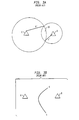
- FIG. 1 illustrates a known method for determining a location from which a mobile caller originates a call on a wireless mobile unit 2.
- the E911 call originating from the wireless mobile unit 2 reaches at least one cellular base station, such as base station 4.
- the signal of the call then typically radiates to a second base station 6 and to a third base station 8.
- Methods for determining such a location include both time difference of arrival (TDOA) and time of arrival (TOA) methods. These two methods are explained as follows.
- TDOA time difference of arrival
- TOA time of arrival
- a first distance “a” between the wireless mobile unit 2 and first base station 4 is estimated; a second distance “b” between the wireless mobile unit 2 and second base station 6 is estimated; and a third distance “c” between the wireless mobile unit 2 and third base station 8 is estimated.
- the approximate distances "a", "b", and "c” are determined using the known TOA method, as follows.
- the coordinates of the wireless mobile unit 2 are represented by (x,y); the coordinates of base station 4 are represented by (x1,y1); the coordinates of base station 6 are represented by (x2,y2); and the coordinates of base station 8 are represented by (x3,y3).
- t1, t2, and t3 represent half of the round trip delay time of signals traveling from base station 4, base station 6, and base station 8, respectively to wireless mobile unit 2 and back.
- T is the processing time of wireless mobile unit 2
- C is the speed of light.
- the absolute time of the signal traveling from the wireless mobile unit 2 to the various base stations is measured to find the distances a, b and c and to eventually arrive at an approximate (x,y) location for the wireless mobile unit 2.
- the clock in the wireless mobile unit 2 may not exactly synchronize with that of the various base stations 4, 6, and 8.
- absolute time is measured by a round trip delay in the time of a signal sent from a particular base station to the wireless mobile unit 2 and back to the base station.
- round trip delay includes processing time in the wireless mobile unit 2 that needs to be estimated. Normally, it can be estimated based on the knowledge of a particular brand of the wireless mobile unit 2.
- TDOA time difference of arrival
- Fig. 2 illustrates an example of a TDOA method involving two hyperbolas with foci at base station 4 and base station 8.
- the hyperbola "ab” is constructed using the TDOA between base station 6 and base station 4, in reference to the wireless mobile unit 2.
- the hyperbola “cd” is constructed by using the TDOA between base station 6 and base station 8, in reference to the wireless mobile unit 2.
- TOA and TDOA can be used in an ideal situation to determine a location of a wireless mobile unit 2.
- both the TOA and TDOA methods require the identification of three base stations, 4, 6 and 8 in order to utilize their methods to determine the location of a wireless mobile unit 2.
- all three base stations 4, 6 and 8 cannot be determined.
- An example of this situation is shown in prior art Fig. 3.
- the known TOA and TDOA methods of detecting a location of a wireless mobile unit 2 in many instances, only provide an estimated location. Additionally, if all three base stations are not detected, the estimated area cannot even be detected.
- barriers such as buildings, for example, can block signals from being received by distant base stations. Accordingly, although the cellular call from wireless mobile unit 2 may still be able to go through, only a single base station may detect the call. If only two of the three base stations (6 and 8 as shown in Fig. 3(a) for example) can be detected, only two distances such as "b'" and "c'" can be calculated, resulting in non-unique solutions. If only one or two base stations can be detected, the location of the wireless mobile unit 2 can only be roughly estimated, at best.
- Fig. 3(a) for example, if only two base stations 6 and 8 are identified in a TOA system, then only two circles can be determined and only a parabolic area 10 can be estimated as the approximately location of a wireless mobile unit 2. Similarly, if only base stations 6 and 8 are identified in a TDOA system, as shown in Fig. 3(b), only one parabola "cd" can be calculated and the location of the wireless mobile unit 2 can only be roughly estimated at best.
- a position locator is used as a type of floating base station for determining a location of a wireless mobile unit emitting a 911 call.
- a distance between the wireless mobile unit and the position locator is estimated, along with the estimated distance between the wireless unit and a single cellular base station, so that the location of the wireless mobile unit emitting the 911 call is accurately determined, even when only one base station receives the call.
- Fig. 4 illustrates a preferred embodiment of the position locator 16 of the present invention.
- the position locator 16 preferably includes a transceiver 18, for transmitting and receiving signals through an antenna 22.
- the antenna 22 may or may not be integrated into the position locator 16 (the position locator 16 may connect to an antenna of an emergency vehicle to carry the position locator 16, for example).
- the position locator 16 further includes a global positioning system (GPS) receiver 20.
- GPS global positioning system
- tx1 and rcv1 preferably illustrate the downlink transceiver portion of transceiver 18 (communicating with the wireless mobile unit 2), while tx2 and rcv2 preferably illustrate the uplink transceiver portion of transceiver 18 (communicating with the base stations 4, 6, 8).
- Digital signal processors, memory and correlators are included within each of the uplink and downlink transceiver portions of transceiver 18.
- the antenna 22 can be a dual mode antenna that serves both transceiver 16 and GPS receiver 20, or separate antenna elements can be used.
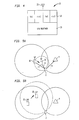
- Figs. 5(a) and 5(b) illustrate the use of a position locator 16 of the present invention using TOA. More specifically, as shown in Fig. 5(a), the position locator 16 transmits and detects signals through transceiver 18 to and from wireless mobile unit 2 and base station 4. The position locator 16 is used as a roving base station to ensure that even if other base stations cannot be detected and even if distances between base stations and the wireless mobile unit 2 cannot be determined, the location of the wireless mobile unit 2 is determined. This is done using either TOA (Figs. 5(a) and 5(b) or TDOA (Figs. 6(a) and 6(b)).
- a primary service area (PSAP) provider servicing the area of the caller utilizing a wireless unit 2 is notified.
- the approximate area of the caller utilizing the wireless unit 2 can be determined by an existing method, such that a PSAP serving that area can be notified.
- the PSAP dispatches a rescue vehicle, that is near the caller, toward the general area, the rescue vehicle being equipped with a position locator 16 of the present invention.
- At least one base station 4 receiving the 911 call from the wireless mobile unit 2 is determined, and the position of the at least one base station 4 is known. Thereafter, through the use of GPS receiver 20 the position of the position locator 16, located in the rescue vehicle is determined.
- the basic element in the algorithm is estimation of the distance denoted by "r1” between base station 4 and the wireless mobile unit 2, and the estimation of the distance denoted by "r2" between the position locator 16 and the wireless mobile unit 2.
- r1 the distance between base station 4 and the wireless mobile unit 2
- r2 the distance between the position locator 16 and the wireless mobile unit 2.
- two circles can be computed as shown in Fig. 5(a) utilizing the coordinates of the position locator 16, received through a GPS receiver 20, as the center of the first circle and "r2" as the radius; and utilizing the coordinates of the base station 4 as the center of the second circle and "r1" as the radius.
- the value of "r1" as shown in Fig. 5(a) is preferably estimated using a round trip delay (RTD) measurement obtained by the base station 4 sending an RTD measurement request to the wireless mobile unit 2 upon receiving an E911 call, for example.
- the wireless mobile unit 2 then immediately responds with a message.
- the base station 4 calculates the RTD by using the time of the measurement request, and the time of the received response from the wireless mobile unit 2.
- the position locator 16 will have to receive the same RTD response that is sent to the base station 4 by the wireless mobile unit 2.
- t0 denotes the time when the base station 4 sends the RTD measurement request
- t1 represents the time when the wireless mobile unit 2 receives the request
- t2 represents the time when the wireless mobile unit 2 sends the response
- t3 represents the time when the base station 4 receives the response from the wireless mobile unit 2
- t4 represents the time when the position locator 16 receives the same RTD response from the wireless mobile unit 2
- the TOA for the position locator 16 can be estimated.
- the position locator 16 Upon receiving the response from the wireless mobile unit 2, the position locator 16 immediately sends the value of t4 to the base station 4 via the uplink transceiver portion tx2 of the transceiver 18.
- the position determination equipment (POE) of the base station 4 performs the TOA calculations set forth above and solves the equations or relays the information to the POE in the mobile switching center (MSC) to solve the equations to determine the location of the wireless mobile unit 2. More specifically, the x,y location of the base station 4 is known, and the x,y position of the position locator 16 is also known based upon information received from GPS receiver 20 of the position locator 16. Accordingly, utilizing the x,y locations of the base station 4 and position locator 16, and utilizing "r1" and "r2" as radii, the respective circles, shown by solid lines in Fig. 5(a) can be determined.
- the position locator 16 To detect the signal from the wireless mobile unit 2, the position locator 16 must know the PN code of the wireless mobile unit 2.
- the primary base station 4 preferably sends this information to the position locator 16 via a dedicated link utilizing a regular traffic channel.
- the position locator 16 must allocate memory space to buffer the signal from the wireless mobile unit 2. Once the position locator 16 receives the PN code of the wireless mobile unit 2 from the primary base station 4 via the uplink receiver rcv2 of transceiver 18, then it will demodulate the signal utilizing the PN code of the wireless mobile unit 2.
- a first circle is determined.
- B X and B Y being the X,Y coordinates of the base station position
- r 1 being the first estimated distance
- a second circle is determined.
- P X and P Y being the X,Y coordinates of position locator 16
- r 2 being the second estimated distance
- the intersections of the two circles can be computed using simultaneous equations. Solving for X and Y results in two X,Y pairs of intersecting points of the two circles, one originating from each of the base station 4 and position locator 16 and each respectively radiating by the estimated first and second distances "r1" and "r2". These two X,Y coordinate pairs represent the two possible locations of the wireless mobile unit 2.
- the rescue vehicle carrying the position locator 16 moves towards one of the two locations.
- the second distance between the position locator 16 and the wireless unit 2 is re-estimated as "r2'", in a similar manner as that previously described, after the position locator has moved toward the selected one of the two calculated intersecting points. It is then determined whether or not the re-estimated second distance "r2'" is shorter than the estimated second distance "r2" (in the base station 4 or MSC). If so, then the selected one of the two calculated intersecting points is chosen as the location of the wireless mobile unit 2. This is because, if the rescue vehicle with the position locator 16 has chosen the correct one of the two possible locations of the wireless mobile unit 2, it will be moving towards the wireless mobile unit 2 and the distance between it and the wireless mobile unit 2 will be decreasing.
- the rescue vehicle is moving in the wrong direction. If so, then the non-selected one of the two calculated intersecting points is chosen as the location of the wireless mobile unit 2 and the rescue vehicle with position locator 16 will thereafter adjust its course toward the correct location of wireless mobile unit 2. This occurs under the direction of the base station 4 or MSC, based upon the determination made by the POE therein. As the rescue vehicle with the position locator 16 moves towards the chosen one of the two calculated intersecting points, the calculations are repeated. The process ends when the distance between the position locator 16 and the wireless mobile unit 2 is approximated to 0.
- the location algorithm for locating the wireless mobile unit 2 as set forth above, is run on an application server attached to the base station 4, referred to as the POE.
- a Kalman Filter is preferably used to track the relative movement of the position locator 16 in the rescue vehicle and the wireless unit 2.
- the POE can be located at the MSC for example.
- Figs. 6(a) and 6(b) illustrate the use of a position locator 16 of the present invention using TDOA.
- Fig. 6(a) illustrates the position located 16 determining one of two possible locations for the wireless mobile unit 2, selecting the correct location, and moving toward the wireless mobile unit 2 (dashed version of position locator 16).
- Fig. 6(b) illustrates the position locator 16 moving away from the wireless mobile unit 2 (dashed version of position locator 16).
- One way to use the position locator 16 using TDOA is to utilize the forward link signal; and another way is to utilize the reverse link signal. Utilizing the forward link, the operation is explained as follows.
- the position locator 16 transmits a pilot signal (pilot PN code) via the downlink transceiver portion of the transceiver 18 (tx1, rcv1).
- the pilot PN code is one that belongs to a very distant base station. This is to avoid conflicting with the local PN codes, so that the system will not hand the call over to the position locator 16 with a particular PN code.
- the MSC receives the transmitted RN code and then adds the PN code of the position locator 16 to a candidate list of wireless mobile units, to let the wireless mobile unit 2 detect this PN code.
- the wireless mobile unit 2 once it detects such a PN code, then reports back to its primary base station 4.
- the reporting back includes the PN code chip offset and the signal strength upon being requested by the base station 4 using a power strength measurement request.
- the base station 4 then calculates the TDOA and solves the equation or relays the information to the MSC to solve the previously mentioned TDOA equations to determine the location of the wireless mobile unit 2, as represented by the solid line hyperbola of Figs. 6(a) and 6(b).
- the position locator 16 is again able to act as a roving base station to ensure that even if other base stations cannot be detected, the location of the wireless mobile unit 2 is detected utilizing the TDOA method.
- a second dashed-line hyperbola is determined in a similar manner to that explained above.
- Fig. 6(b) illustrates the contrary situation, where the position locator 16 moves away from the wireless mobile unit 2, and a different dashed-line hyperbola is determined in a similar manner to that explained above.
- the two hyperbolas of both Figs. 6(a) and 6(b) will intersect, as shown, at the location of the wireless mobile unit 2 and the correct location can therefore be determined using TDOA, in a manner similar to that described previously using TOA with regard to Fig. 5.
- Another option for specifically utilizing the position locator 16 in a TDOA method is to use a reverse link signal.
- the wireless mobile unit 2 transmits a traffic signal as usual in making or emitting its E911 call.
- the primary base station 4 then demodulates this signal.
- the base station 4 transmits the PN code of the wireless mobile unit 2 to the position locator 16.
- the position locator 16 also receives the traffic signal from the wireless mobile unit 2 and buffers it utilizing allocated memory space. Upon receiving the PN code of the wireless mobile unit 2 from base station 4 via the uplink receiver portion of transceiver 18 (rcv2), the position locator 16 demodulates the traffic signal of the wireless mobile unit 2.
- the position locator 16 then sends the chip offset (with 1/8 chip resolution) to the base station 4 via the uplink transmitter portion of the transceiver 18 (tx2).
- the base station 4 then calculates the TDOA and solves the equations or relays the information to MSC to solve the equations to determine the location of the wireless mobile unit 2 in a known manner utilizing the TDOA equations previously described.
- Figs. 5(a) and 5(b) and 6(a) and 6(b) involve a situation where only one base station 4 can detect a call emanating from a wireless mobile unit 2.
- the system and method of the present application utilizing a position locator 16, can also readily detect or determine an originating location of the wireless unit 2 based upon the determined location of more than one base station. Accordingly, if two base stations or all three base stations are detected, the originating location of the wireless mobile unit 2 can also be detected.
- another equation based on the distance between the position locator 16 and one mobile unit can be used to determine the unique solution for the location of the wireless unit 2, for example.
- the present invention was designed to be used to locate a caller with a wireless mobile unit 2 calling an emergency 911 number under various RF propagation conditions, it should not be limited thereto.
- the present invention can be used to identify the position of any wireless mobile unit 2 for any reason.
- the position locator 16 has been discussed as preferably being located in a rescue vehicle such as an ambulance or a police car for example, but should not be limited thereto.
- the position locator 16 is preferably a portable unit which can be carried or placed on a person or in any type of vehicle.
- the base station 4 has preferably been discussed as running the position locating algorithm or method. However, it should be readily recognizable to one of ordinary skill in the art that the algorithm could be run in the MSC or utilizing a microprocessor and memory (not shown) built within the position locator 16 shown in Fig. 3 for example.
Landscapes
- Engineering & Computer Science (AREA)
- Radar, Positioning & Navigation (AREA)
- Remote Sensing (AREA)
- Physics & Mathematics (AREA)
- General Physics & Mathematics (AREA)
- Computer Networks & Wireless Communication (AREA)
- Signal Processing (AREA)
- Mobile Radio Communication Systems (AREA)
- Position Fixing By Use Of Radio Waves (AREA)
Applications Claiming Priority (2)
| Application Number | Priority Date | Filing Date | Title |
|---|---|---|---|
| US09/215,344 US6741863B1 (en) | 1998-12-18 | 1998-12-18 | Method and apparatus for locating a wireless mobile unit |
| US215344 | 1998-12-18 |
Publications (2)
| Publication Number | Publication Date |
|---|---|
| EP1014105A2 true EP1014105A2 (fr) | 2000-06-28 |
| EP1014105A3 EP1014105A3 (fr) | 2002-03-13 |
Family
ID=22802614
Family Applications (1)
| Application Number | Title | Priority Date | Filing Date |
|---|---|---|---|
| EP99309797A Ceased EP1014105A3 (fr) | 1998-12-18 | 1999-12-07 | Procédé et dispositif de positionnement d'une unité sans fil |
Country Status (6)
| Country | Link |
|---|---|
| US (1) | US6741863B1 (fr) |
| EP (1) | EP1014105A3 (fr) |
| JP (1) | JP2000184430A (fr) |
| KR (1) | KR100676005B1 (fr) |
| AU (1) | AU6171299A (fr) |
| CA (1) | CA2289049A1 (fr) |
Cited By (8)
| Publication number | Priority date | Publication date | Assignee | Title |
|---|---|---|---|---|
| WO2002037134A3 (fr) * | 2000-10-31 | 2002-10-24 | Abatec Electronic Ag | Procede et dispositif permettant de determiner une position |
| EP2211582A1 (fr) * | 2009-01-23 | 2010-07-28 | Deutsches Zentrum für Luft- und Raumfahrt e.V. | Procédé de détermination de la position d'un terminal mobile |
| US8774837B2 (en) | 2011-04-30 | 2014-07-08 | John Anthony Wright | Methods, systems and apparatuses of emergency vehicle locating and the disruption thereof |
| CN104459620A (zh) * | 2014-12-09 | 2015-03-25 | 复旦大学无锡研究院 | 一种无线定位装置及方法 |
| CN106954388A (zh) * | 2014-08-22 | 2017-07-14 | 赫博·贝雯 | 传感器系统 |
| CN107484135A (zh) * | 2017-07-14 | 2017-12-15 | 惠州Tcl移动通信有限公司 | 一种用于室内定位的智能终端及其定位方法 |
| CN107830856A (zh) * | 2017-11-29 | 2018-03-23 | 武汉科技大学 | 面向编队飞行的太阳tdoa量测方法及组合导航方法 |
| EP3764121A1 (fr) * | 2019-07-09 | 2021-01-13 | Rockwell Collins, Inc. | Système et procédé d'estimation différentielle aveugle de temps d'arrivée |
Families Citing this family (66)
| Publication number | Priority date | Publication date | Assignee | Title |
|---|---|---|---|---|
| GB9915841D0 (en) * | 1999-07-06 | 1999-09-08 | Nokia Telecommunications Oy | Location of a station |
| US7783508B2 (en) | 1999-09-20 | 2010-08-24 | Numerex Corp. | Method and system for refining vending operations based on wireless data |
| GB9928416D0 (en) * | 1999-12-01 | 2000-01-26 | Nokia Networks Oy | A telecommunications system |
| US7623447B1 (en) * | 2000-04-10 | 2009-11-24 | Nokia Corporation | Telephony services in mobile IP networks |
| US7298697B2 (en) * | 2000-04-10 | 2007-11-20 | Nokia Corporation | Setting a communication channel |
| US20020016173A1 (en) * | 2000-06-21 | 2002-02-07 | Hunzinger Jason F. | Communication of location information in a wireless communication system |
| US7245928B2 (en) | 2000-10-27 | 2007-07-17 | Cellemetry, Llc | Method and system for improved short message services |
| JP3575542B2 (ja) * | 2000-12-08 | 2004-10-13 | 日本電気株式会社 | 移動機位置検索システム及び移動機位置検索方法 |
| JP2002199428A (ja) * | 2000-12-27 | 2002-07-12 | Toshiba Corp | 移動通信端末装置とそのハンドオーバ制御方法及び制御プログラム |
| US20030014495A1 (en) * | 2001-07-10 | 2003-01-16 | Jogen Pathak | System, method, and apparatus for preventing data packet overflow at node in wireless packet data services network |
| US6907252B2 (en) * | 2001-07-11 | 2005-06-14 | Lucent Technologies Inc. | Method and apparatus for detecting the presence of mobile terminals |
| US20030065736A1 (en) * | 2001-07-25 | 2003-04-03 | Pathak Jogen K. | System, method, and apparatus for preventing data packet overflow at plurality of nodes in wireless packet data services network |
| US7647422B2 (en) * | 2001-11-06 | 2010-01-12 | Enterasys Networks, Inc. | VPN failure recovery |
| GB2382270B (en) * | 2001-11-16 | 2006-06-14 | Nec Technologies | Improved location systems in cellular communications networks |
| US8972589B2 (en) | 2002-03-01 | 2015-03-03 | Enterasys Networks, Inc. | Location-based access control in a data network |
| GB0207129D0 (en) * | 2002-03-26 | 2002-05-08 | Nokia Corp | Positioning-triggered handover |
| US6718237B1 (en) * | 2002-03-28 | 2004-04-06 | Numerex Investment Corp. | Method for reducing capacity demands for conveying geographic location information over capacity constrained wireless systems |
| US6973320B2 (en) * | 2002-04-29 | 2005-12-06 | Motorola, Inc. | Method and apparatus for locating a remote unit within a communication system |
| US6768459B2 (en) | 2002-07-31 | 2004-07-27 | Interdigital Technology Corporation | Method and system for positioning mobile units based on angle measurements |
| US20060171335A1 (en) * | 2005-02-03 | 2006-08-03 | Michael Yuen | Backup channel selection in wireless LANs |
| US7606573B1 (en) | 2002-09-27 | 2009-10-20 | Autocell Laboratories, Inc. | Wireless switched network |
| US7050786B2 (en) * | 2002-10-30 | 2006-05-23 | Lockheed Martin Corporation | Method and apparatus for locating a wireless device |
| US7050787B2 (en) * | 2002-10-30 | 2006-05-23 | Lockheed Martin Corporation | Cooperative element location system |
| WO2004077711A2 (fr) * | 2003-02-24 | 2004-09-10 | Hawe William R | Systeme, procede et appareil de determination d'un attribut dynamique d'un systeme |
| US7869822B2 (en) * | 2003-02-24 | 2011-01-11 | Autocell Laboratories, Inc. | Wireless network apparatus and system field of the invention |
| JP3632025B2 (ja) * | 2003-02-26 | 2005-03-23 | Tdk株式会社 | 薄膜磁気ヘッド、ヘッドジンバルアセンブリ、及び、ハードディスク装置 |
| US7047020B2 (en) * | 2003-07-16 | 2006-05-16 | Qualcomm Inc. | Assistance techniques for subscriber units having positioning capabilities |
| US7323970B1 (en) | 2004-01-21 | 2008-01-29 | Numerex Corporation | Method and system for remote interaction with a vehicle via wireless communication |
| US7366169B1 (en) | 2004-02-18 | 2008-04-29 | Autocell Laboratories, Inc. | Apparatus for scanning radio frequency channels |
| US20050195756A1 (en) * | 2004-02-26 | 2005-09-08 | Frattura David E. | Status announcement system and method |
| US7580403B2 (en) * | 2004-02-26 | 2009-08-25 | Enterasys Networks, Inc. | Status transmission system and method |
| US20060037075A1 (en) * | 2004-03-10 | 2006-02-16 | Frattura David E | Dynamic network detection system and method |
| US7945945B2 (en) * | 2004-08-06 | 2011-05-17 | Enterasys Networks, Inc. | System and method for address block enhanced dynamic network policy management |
| US7347628B2 (en) | 2004-11-08 | 2008-03-25 | Enterasys Networks, Inc. | Optical interface identification system |
| US20060171304A1 (en) * | 2005-02-03 | 2006-08-03 | Hill David R | WLAN background scanning |
| US20060171305A1 (en) * | 2005-02-03 | 2006-08-03 | Autocell Laboratories, Inc. | Access point channel forecasting for seamless station association transition |
| US8260323B1 (en) | 2005-02-24 | 2012-09-04 | Agere Systems Inc. | Utilization of existing network infrastructure to provide person tracking capabilities |
| JP2006238158A (ja) | 2005-02-25 | 2006-09-07 | Nec Corp | 無線通信システム、基地局制御装置、無線端末及び無線通信方法 |
| US7636061B1 (en) | 2005-04-21 | 2009-12-22 | Alan Thomas | Method and apparatus for location determination of people or objects |
| US8086232B2 (en) * | 2005-06-28 | 2011-12-27 | Enterasys Networks, Inc. | Time synchronized wireless method and operations |
| US20070076674A1 (en) * | 2005-09-30 | 2007-04-05 | Golden Stuart A | Apparatus and method locating a mobile communication unit |
| US8411616B2 (en) | 2005-11-03 | 2013-04-02 | Piccata Fund Limited Liability Company | Pre-scan for wireless channel selection |
| RU2413959C2 (ru) * | 2006-03-06 | 2011-03-10 | Квэлкомм Инкорпорейтед | Способ определения положения путем сшивания измерений |
| WO2007136723A2 (fr) | 2006-05-17 | 2007-11-29 | Numerex Corp. | Système et procédé pour prolonger la vie d'un produit numérique radio |
| US7844280B2 (en) * | 2006-12-12 | 2010-11-30 | Trueposition, Inc. | Location of wideband OFDM transmitters with limited receiver bandwidth |
| US7797000B2 (en) | 2006-12-01 | 2010-09-14 | Trueposition, Inc. | System for automatically determining cell transmitter parameters to facilitate the location of wireless devices |
| US7920875B2 (en) * | 2006-12-01 | 2011-04-05 | Trueposition, Inc. | Subscriptionless location of wireless devices |
| US7616155B2 (en) * | 2006-12-27 | 2009-11-10 | Bull Jeffrey F | Portable, iterative geolocation of RF emitters |
| US8265605B2 (en) | 2007-02-06 | 2012-09-11 | Numerex Corp. | Service escrowed transportable wireless event reporting system |
| US8571553B2 (en) * | 2007-07-16 | 2013-10-29 | Qualcomm Incorporated | Methods and apparatus for resolving pilot pseudorandom noise code conflicts in a communication system |
| US8706392B2 (en) * | 2009-05-07 | 2014-04-22 | Toyota Jidosha Kabushiki Kaisha | Distance detection device and collision determination device |
| US9002354B2 (en) * | 2009-06-12 | 2015-04-07 | Google Technology Holdings, LLC | Interference control, SINR optimization and signaling enhancements to improve the performance of OTDOA measurements |
| US9074897B2 (en) | 2009-06-15 | 2015-07-07 | Qualcomm Incorporated | Real-time data with post-processing |
| KR20100135503A (ko) * | 2009-06-17 | 2010-12-27 | 삼성전자주식회사 | 무선통신 시스템에서 핸드오버 결정 방법 및 장치 |
| US8340629B2 (en) * | 2009-09-11 | 2012-12-25 | General Motors Llc | Method of contacting a PSAP |
| US8704707B2 (en) | 2010-06-02 | 2014-04-22 | Qualcomm Incorporated | Position determination using measurements from past and present epochs |
| US9288626B2 (en) | 2012-11-29 | 2016-03-15 | Spectrum Bridge, Inc. | System and method for determining precise geo-location of a fixed-location radio device |
| EP2926540B1 (fr) * | 2012-11-29 | 2017-10-11 | QUALCOMM Incorporated | Système et procédé pour déterminer et vérifier l'emplacement géographique d'un dispositif radio |
| US9154920B2 (en) * | 2013-03-01 | 2015-10-06 | Lear Corporation | System and method for detecting a location of a wireless device |
| AU2013400684B2 (en) * | 2013-09-20 | 2018-05-17 | Caterpillar Inc. | Positioning system using radio frequency signals |
| KR102203391B1 (ko) * | 2015-05-29 | 2021-01-15 | 한국전자기술연구원 | 차량용 단말을 위한 위치인지 방법 및 시스템 |
| US11259165B2 (en) | 2016-08-26 | 2022-02-22 | Intrinsic Value, Llc | Systems, devices, and methods for emergency responses and safety |
| US10306449B2 (en) | 2016-08-26 | 2019-05-28 | Intrinsic Value, Llc | Systems, devices, and methods for emergency responses and safety |
| US10506413B2 (en) | 2017-08-28 | 2019-12-10 | Intrinsic Value, Llc | Systems, devices, and methods for emergency responses and safety |
| JP6832794B2 (ja) * | 2017-06-05 | 2021-02-24 | ルネサスエレクトロニクス株式会社 | 無線通信システム |
| KR102590367B1 (ko) * | 2021-09-15 | 2023-10-17 | 주식회사 리안 | 칼만 필터를 이용한 해상 조난자 위치 예측 시스템 |
Family Cites Families (20)
| Publication number | Priority date | Publication date | Assignee | Title |
|---|---|---|---|---|
| CA2089123A1 (fr) * | 1992-03-04 | 1993-09-05 | Robert Edwin Penny, Jr. | Emetteur-recepteur permettant de determiner une position |
| US5583517A (en) * | 1992-08-20 | 1996-12-10 | Nexus 1994 Limited | Multi-path resistant frequency-hopped spread spectrum mobile location system |
| US5777580A (en) * | 1992-11-18 | 1998-07-07 | Trimble Navigation Limited | Vehicle location system |
| EP0717852A1 (fr) | 1994-07-08 | 1996-06-26 | Lockheed Martin Corporation | Appareil et procede de localisation de telephones cellulaires et d'emetteurs similaires |
| US5592173A (en) * | 1994-07-18 | 1997-01-07 | Trimble Navigation, Ltd | GPS receiver having a low power standby mode |
| US5680140A (en) * | 1994-07-19 | 1997-10-21 | Trimble Navigation Limited | Post-processing of inverse differential corrections for SATPS mobile stations |
| US6028551A (en) * | 1994-12-13 | 2000-02-22 | Schoen; Neil Charles | Micro-miniature beacon transmit-only geo-location emergency system for personal security |
| US5583776A (en) * | 1995-03-16 | 1996-12-10 | Point Research Corporation | Dead reckoning navigational system using accelerometer to measure foot impacts |
| US5689431A (en) * | 1995-04-18 | 1997-11-18 | Leading Edge Technologies, Inc. | Golf course yardage and information system |
| US5717406A (en) * | 1995-06-07 | 1998-02-10 | Sanconix Inc. | Enhanced position calculation |
| US6083248A (en) * | 1995-06-23 | 2000-07-04 | Medtronic, Inc. | World wide patient location and data telemetry system for implantable medical devices |
| JP2865043B2 (ja) * | 1996-02-02 | 1999-03-08 | 日本電気株式会社 | 移動体無線電話装置 |
| US5890068A (en) | 1996-10-03 | 1999-03-30 | Cell-Loc Inc. | Wireless location system |
| US5784339A (en) * | 1997-04-16 | 1998-07-21 | Ocean Vision Technology, Inc. | Underwater location and communication system |
| DE19721504C1 (de) * | 1997-05-22 | 1998-11-12 | Siemens Ag | Verfahren und Vorrichtung zur Positionsbestimmung |
| US5952969A (en) * | 1997-08-18 | 1999-09-14 | Telefonakiebolaget L M Ericsson (Publ) | Method and system for determining the position of mobile radio terminals |
| US6054950A (en) * | 1998-01-26 | 2000-04-25 | Multispectral Solutions, Inc. | Ultra wideband precision geolocation system |
| US6097959A (en) * | 1998-01-29 | 2000-08-01 | Ericsson Inc. | System and method for accurate positioning of mobile terminals |
| US6014102A (en) * | 1998-04-17 | 2000-01-11 | Motorola, Inc. | Method and apparatus for calibrating location finding equipment within a communication system |
| US6141558A (en) * | 1998-05-07 | 2000-10-31 | Motorola, Inc. | Method and apparatus for locating a subscriber unit in a communication system |
-
1998
- 1998-12-18 US US09/215,344 patent/US6741863B1/en not_active Expired - Lifetime
-
1999
- 1999-11-08 CA CA002289049A patent/CA2289049A1/fr not_active Abandoned
- 1999-11-26 AU AU61712/99A patent/AU6171299A/en not_active Abandoned
- 1999-12-07 EP EP99309797A patent/EP1014105A3/fr not_active Ceased
- 1999-12-17 JP JP11359569A patent/JP2000184430A/ja active Pending
- 1999-12-18 KR KR1019990058920A patent/KR100676005B1/ko not_active Expired - Lifetime
Cited By (10)
| Publication number | Priority date | Publication date | Assignee | Title |
|---|---|---|---|---|
| WO2002037134A3 (fr) * | 2000-10-31 | 2002-10-24 | Abatec Electronic Ag | Procede et dispositif permettant de determiner une position |
| EP2211582A1 (fr) * | 2009-01-23 | 2010-07-28 | Deutsches Zentrum für Luft- und Raumfahrt e.V. | Procédé de détermination de la position d'un terminal mobile |
| US8774837B2 (en) | 2011-04-30 | 2014-07-08 | John Anthony Wright | Methods, systems and apparatuses of emergency vehicle locating and the disruption thereof |
| CN106954388A (zh) * | 2014-08-22 | 2017-07-14 | 赫博·贝雯 | 传感器系统 |
| CN104459620A (zh) * | 2014-12-09 | 2015-03-25 | 复旦大学无锡研究院 | 一种无线定位装置及方法 |
| CN107484135A (zh) * | 2017-07-14 | 2017-12-15 | 惠州Tcl移动通信有限公司 | 一种用于室内定位的智能终端及其定位方法 |
| CN107830856A (zh) * | 2017-11-29 | 2018-03-23 | 武汉科技大学 | 面向编队飞行的太阳tdoa量测方法及组合导航方法 |
| CN107830856B (zh) * | 2017-11-29 | 2021-07-20 | 武汉科技大学 | 面向编队飞行的太阳tdoa量测方法及组合导航方法 |
| EP3764121A1 (fr) * | 2019-07-09 | 2021-01-13 | Rockwell Collins, Inc. | Système et procédé d'estimation différentielle aveugle de temps d'arrivée |
| US11378645B2 (en) | 2019-07-09 | 2022-07-05 | Rockwell Collins, Inc. | System and method for blind differential time-of-arrival estimation |
Also Published As
| Publication number | Publication date |
|---|---|
| US6741863B1 (en) | 2004-05-25 |
| KR100676005B1 (ko) | 2007-01-29 |
| CA2289049A1 (fr) | 2000-06-18 |
| KR20000062208A (ko) | 2000-10-25 |
| EP1014105A3 (fr) | 2002-03-13 |
| AU6171299A (en) | 2000-06-22 |
| JP2000184430A (ja) | 2000-06-30 |
Similar Documents
| Publication | Publication Date | Title |
|---|---|---|
| US6741863B1 (en) | Method and apparatus for locating a wireless mobile unit | |
| US6438380B1 (en) | System for robust location of a mobile-transmitter | |
| EP2818886B1 (fr) | Procédé de positionnement de réseau et équipement connexe | |
| KR100865052B1 (ko) | 무선통신네트워크에서 gps 위성신호획득 보조 시스템및 방법 | |
| US7640025B2 (en) | Method and system for determining the altitude of a mobile wireless device | |
| JP5405334B2 (ja) | 無線通信信号による衛星位置決めの強化 | |
| KR100691397B1 (ko) | 낮은 정확도의 클록을 사용하여 이동 통신 장치의 위치를결정하기 위한 방법 및 장치 | |
| EP1271986B1 (fr) | Méthode et système de détermination de la position de stations mobiles | |
| RU2197780C2 (ru) | Приемник глобальной системы позиционирования с ограниченным пространством поиска кодового сдвига для сотовой телефонной системы | |
| JP4527930B2 (ja) | ポジションロケーションシステムの較正方法およびそのためのシステムおよびメモリ | |
| US6408246B1 (en) | Remote terminal location algorithm | |
| KR100553305B1 (ko) | 이동국 위치 픽스를 유효화하는 방법 및 시스템 | |
| US7345582B2 (en) | Methods for detecting, computing and disseminating location information of weapons of mass destruction | |
| AU2004301199A1 (en) | A method and apparatus for finding a mobile radio terminal | |
| RU2000126289A (ru) | Система и способ определения положения беспроводного приемопередатчика системы множественного доступа с кодовым разделением каналов | |
| US6934548B1 (en) | Methods for detecting, computing and disseminating location information associated with emergency 911 wireless transmissions | |
| US20050025095A1 (en) | Access method of a mobile station for extending cell service range and a method for serving an extended range cell in a mobile communication system | |
| JP3746210B2 (ja) | 位置測定システムおよび位置測定方法 | |
| JPH099339A (ja) | 移動通信システムを用いた測位方式及び移動通信システムの呼出方式 | |
| JP4982566B2 (ja) | 建物内の移動局の位置特定 | |
| KR20000014750A (ko) | 글로벌 포지셔닝 시스템을 사용한 이동통신/개인 휴대 통신 시스템의 위치 추적 방법 | |
| KR101855378B1 (ko) | 이종망 이동통신을 이용한 무선 측위 방법 | |
| Nasser | Automatic location systems for mobile phones | |
| KR20000039417A (ko) | 이동통신망을 이용한 측위용 복합 단말기및 그를 이용한 측위관련 부가서비스 제공방법 | |
| KR20090004168A (ko) | 위치 기반 서비스 센서를 이용하는 셀룰러 통신 시스템에서위치 기반 서비스 제공 방법 |
Legal Events
| Date | Code | Title | Description |
|---|---|---|---|
| PUAI | Public reference made under article 153(3) epc to a published international application that has entered the european phase |
Free format text: ORIGINAL CODE: 0009012 |
|
| AK | Designated contracting states |
Kind code of ref document: A2 Designated state(s): AT BE CH CY DE DK ES FI FR GB GR IE IT LI LU MC NL PT SE Kind code of ref document: A2 Designated state(s): DE FI FR GB SE |
|
| AX | Request for extension of the european patent |
Free format text: AL;LT;LV;MK;RO;SI |
|
| PUAL | Search report despatched |
Free format text: ORIGINAL CODE: 0009013 |
|
| AK | Designated contracting states |
Kind code of ref document: A3 Designated state(s): AT BE CH CY DE DK ES FI FR GB GR IE IT LI LU MC NL PT SE |
|
| AX | Request for extension of the european patent |
Free format text: AL;LT;LV;MK;RO;SI |
|
| 17P | Request for examination filed |
Effective date: 20020831 |
|
| AKX | Designation fees paid |
Free format text: DE FI FR GB SE |
|
| 17Q | First examination report despatched |
Effective date: 20031111 |
|
| RAP3 | Party data changed (applicant data changed or rights of an application transferred) |
Owner name: LUCENT TECHNOLOGIES INC. |
|
| STAA | Information on the status of an ep patent application or granted ep patent |
Free format text: STATUS: THE APPLICATION HAS BEEN REFUSED |
|
| 18R | Application refused |
Effective date: 20091101 |