EP1260953A2 - Système de navigation utilisant un terminal portable - Google Patents
Système de navigation utilisant un terminal portable Download PDFInfo
- Publication number
- EP1260953A2 EP1260953A2 EP02009962A EP02009962A EP1260953A2 EP 1260953 A2 EP1260953 A2 EP 1260953A2 EP 02009962 A EP02009962 A EP 02009962A EP 02009962 A EP02009962 A EP 02009962A EP 1260953 A2 EP1260953 A2 EP 1260953A2
- Authority
- EP
- European Patent Office
- Prior art keywords
- vehicle
- route
- optimum route
- guiding
- optimum
- Prior art date
- Legal status (The legal status is an assumption and is not a legal conclusion. Google has not performed a legal analysis and makes no representation as to the accuracy of the status listed.)
- Withdrawn
Links
Images









Classifications
-
- G—PHYSICS
- G08—SIGNALLING
- G08G—TRAFFIC CONTROL SYSTEMS
- G08G1/00—Traffic control systems for road vehicles
- G08G1/09—Arrangements for giving variable traffic instructions
- G08G1/0962—Arrangements for giving variable traffic instructions having an indicator mounted inside the vehicle, e.g. giving voice messages
- G08G1/0968—Systems involving transmission of navigation instructions to the vehicle
- G08G1/096805—Systems involving transmission of navigation instructions to the vehicle where the transmitted instructions are used to compute a route
- G08G1/096811—Systems involving transmission of navigation instructions to the vehicle where the transmitted instructions are used to compute a route where the route is computed offboard
-
- G—PHYSICS
- G01—MEASURING; TESTING
- G01C—MEASURING DISTANCES, LEVELS OR BEARINGS; SURVEYING; NAVIGATION; GYROSCOPIC INSTRUMENTS; PHOTOGRAMMETRY OR VIDEOGRAMMETRY
- G01C21/00—Navigation; Navigational instruments not provided for in groups G01C1/00 - G01C19/00
- G01C21/26—Navigation; Navigational instruments not provided for in groups G01C1/00 - G01C19/00 specially adapted for navigation in a road network
- G01C21/34—Route searching; Route guidance
- G01C21/3453—Special cost functions, i.e. other than distance or default speed limit of road segments
- G01C21/3492—Special cost functions, i.e. other than distance or default speed limit of road segments employing speed data or traffic data, e.g. real-time or historical
-
- G—PHYSICS
- G01—MEASURING; TESTING
- G01C—MEASURING DISTANCES, LEVELS OR BEARINGS; SURVEYING; NAVIGATION; GYROSCOPIC INSTRUMENTS; PHOTOGRAMMETRY OR VIDEOGRAMMETRY
- G01C21/00—Navigation; Navigational instruments not provided for in groups G01C1/00 - G01C19/00
- G01C21/26—Navigation; Navigational instruments not provided for in groups G01C1/00 - G01C19/00 specially adapted for navigation in a road network
- G01C21/34—Route searching; Route guidance
- G01C21/36—Input/output arrangements for on-board computers
- G01C21/3626—Details of the output of route guidance instructions
- G01C21/3629—Guidance using speech or audio output, e.g. text-to-speech
-
- G—PHYSICS
- G01—MEASURING; TESTING
- G01C—MEASURING DISTANCES, LEVELS OR BEARINGS; SURVEYING; NAVIGATION; GYROSCOPIC INSTRUMENTS; PHOTOGRAMMETRY OR VIDEOGRAMMETRY
- G01C21/00—Navigation; Navigational instruments not provided for in groups G01C1/00 - G01C19/00
- G01C21/26—Navigation; Navigational instruments not provided for in groups G01C1/00 - G01C19/00 specially adapted for navigation in a road network
- G01C21/34—Route searching; Route guidance
- G01C21/36—Input/output arrangements for on-board computers
- G01C21/3626—Details of the output of route guidance instructions
- G01C21/3632—Guidance using simplified or iconic instructions, e.g. using arrows
-
- G—PHYSICS
- G08—SIGNALLING
- G08G—TRAFFIC CONTROL SYSTEMS
- G08G1/00—Traffic control systems for road vehicles
- G08G1/09—Arrangements for giving variable traffic instructions
- G08G1/0962—Arrangements for giving variable traffic instructions having an indicator mounted inside the vehicle, e.g. giving voice messages
- G08G1/0968—Systems involving transmission of navigation instructions to the vehicle
- G08G1/096805—Systems involving transmission of navigation instructions to the vehicle where the transmitted instructions are used to compute a route
- G08G1/096811—Systems involving transmission of navigation instructions to the vehicle where the transmitted instructions are used to compute a route where the route is computed offboard
- G08G1/096816—Systems involving transmission of navigation instructions to the vehicle where the transmitted instructions are used to compute a route where the route is computed offboard where the complete route is transmitted to the vehicle at once
-
- G—PHYSICS
- G08—SIGNALLING
- G08G—TRAFFIC CONTROL SYSTEMS
- G08G1/00—Traffic control systems for road vehicles
- G08G1/09—Arrangements for giving variable traffic instructions
- G08G1/0962—Arrangements for giving variable traffic instructions having an indicator mounted inside the vehicle, e.g. giving voice messages
- G08G1/0968—Systems involving transmission of navigation instructions to the vehicle
- G08G1/096805—Systems involving transmission of navigation instructions to the vehicle where the transmitted instructions are used to compute a route
- G08G1/096827—Systems involving transmission of navigation instructions to the vehicle where the transmitted instructions are used to compute a route where the route is computed onboard
-
- G—PHYSICS
- G08—SIGNALLING
- G08G—TRAFFIC CONTROL SYSTEMS
- G08G1/00—Traffic control systems for road vehicles
- G08G1/09—Arrangements for giving variable traffic instructions
- G08G1/0962—Arrangements for giving variable traffic instructions having an indicator mounted inside the vehicle, e.g. giving voice messages
- G08G1/0968—Systems involving transmission of navigation instructions to the vehicle
- G08G1/096855—Systems involving transmission of navigation instructions to the vehicle where the output is provided in a suitable form to the driver
- G08G1/096861—Systems involving transmission of navigation instructions to the vehicle where the output is provided in a suitable form to the driver where the immediate route instructions are output to the driver, e.g. arrow signs for next turn
-
- G—PHYSICS
- G08—SIGNALLING
- G08G—TRAFFIC CONTROL SYSTEMS
- G08G1/00—Traffic control systems for road vehicles
- G08G1/09—Arrangements for giving variable traffic instructions
- G08G1/0962—Arrangements for giving variable traffic instructions having an indicator mounted inside the vehicle, e.g. giving voice messages
- G08G1/0968—Systems involving transmission of navigation instructions to the vehicle
- G08G1/096855—Systems involving transmission of navigation instructions to the vehicle where the output is provided in a suitable form to the driver
- G08G1/096872—Systems involving transmission of navigation instructions to the vehicle where the output is provided in a suitable form to the driver where instructions are given per voice
Definitions
- the present invention relates generally to a navigation system, and in particular, to a route entry guiding device and method in a navigation system using a portable terminal.
- GPS Global Positioning System
- a typical navigation system pinpoints the present position of a moving object on a displayed map using GPS information. It also provides information necessary for driving, such as the direction the moving object is pointing (heading), the present speed of the moving object, a route set by a driver before he starts, and an optimum route to his destination.
- This navigation system calculates the present position of the moving object based on GPS satellite signals including three-dimensional coordinate information (latitude, longitude and altitude) and provides map information including the present position to the driver visibly or audibly.
- a navigation device includes a GPS receiver for receiving GPS satellite signals and calculating pseudo-present position coordinates, a sensor unit having a gyro-sensor and a speed sensor for sensing the turning direction and speed of a vehicle, respectively, and a map data storage.
- a navigation-enabled vehicle receives traffic information through an LCD (Liquid Crystal Display) and a speaker of a portable terminal.
- the traffic information contains traffic conditions or route guidance for guiding the driver to avoid congested roads. This is disclosed in Korea Patent Application No. 47955, entitled “Navigation System Using Portable Terminal and Route Guiding Method Thereof' and filed on August 18, 2000 by the present applicant.
- Conventional navigation services are limited only to route guidance when a driver travels in a route provided from a traffic information center or a CD-ROM (Compact Disk-Read Only Memory) and simply pinpoints the position of a vehicle on a digital map displayed on an LCD when off track from the route.
- conventional navigation systems provide route guidance information visibly or audibly only if the vehicle is on a predetermined road on the digital map, and provides no guidance to the driver when off track.
- an object of the present invention to provide a route entry guiding device and method for guiding a vehicle to an entry to a route in a navigation system using a portable terminal.
- a navigation component of the portable terminal has a transmitter/receiver, a guiding mode determiner, a heading determiner, a projection direction determiner, and a route direction determiner.
- the transmitter/receiver transmits information including a departure point and a destination entered by a user to a traffic information center over a wireless network and receives optimum route data from the traffic information center over the wireless network in response to the transmitted information.
- the guiding mode determiner calculates the shortest distance to an optimum route indicated by the optimum route data and determines a guiding mode according to the shortest distance, if the optimum route data does not include a road where a vehicle is currently positioned.
- the heading determiner determines the heading of the vehicle with respect to true north using the latitude and longitude coordinates of two points measured by a GPS.
- the projection direction determiner calculates a relative angle of a projection direction to the optimum route with respect to the vehicle and determines the direction to the optimum route according to the calculated relative projection direction angle.
- the route direction determiner calculates a relative angle of the direction the optimum route runs with respect to the vehicle and determines a route direction according to the calculated relative route direction angle. According to the determined guiding mode, direction to the optimum route, and route direction, the vehicle is guided to the entry to the optimum route.
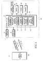
- FIG. 1 is a block diagram illustrating a navigation component for guiding a driver to a route entry and a traffic information center for wirelessly communicating with the navigation component according to an embodiment of the present invention.
- a controller 10 provides overall control to the navigation component capable of route entry guidance. If the navigation component co-functions as a mobile terminal, the controller 10 controls both mobile communication and route entry guidance.
- the controller 10 includes a route guidance processor 10a and a route entry guidance processor 10b.
- the route entry guidance processor 10b includes of a guiding mode determiner b-1, a heading determiner b-2, a projection direction determiner b-3, and a route direction determiner b-4.
- a transmitter/receiver 12 processes a navigation signal and a mobile communication signal discriminately. With a navigation signal, the transmitter/receiver 12 feeds the navigation signal to a navigation sensor unit 14 and, at the same time, it notifies the controller 10 that the input signal is the navigation signal. With a mobile communication signal, the transmitter/receiver 12 outputs a signal indicating the reception of the signal from a mobile communication system to the controller 10 and the received signal to a voice processor 16. Only voice data is output to the voice processor 16. Upon receipt of text data or graphic data, the transmitter/receiver 12 outputs either to the controller 10.
- the voice processor 16 converts the received voice data to an electrical voice signal by decoding and decompressing, and outputs the voice signal to a speaker SPK.
- the voice processor 16 also converts an electrical voice signal received from a microphone MIC to voice data by compressing and encoding, and outputs the voice data to the transmitter/receiver 12.
- the voice processor 16 processes a voice message for route entry guidance under the control of the controller 10 and outputs it through the speaker SPK.
- a display 18 displays the operational state of the terminal in a mobile communication mode under the control of the controller 10. Using route entry guidance according to the present invention, the display 18 displays route entry guidance-related information under the control of the controller 10. During a navigation service, after the route entry guidance, the display 18 displays route information, direction information, and a reservation alarm sign under the control of the controller 10.
- a memory 22 has an area for storing programs necessary to operate the navigation component as a mobile terminal, an area for storing optimum route data needed to guide the user to an entry of a route, and an area for temporarily storing data generated during a control operation.
- FIGs. 2A to 2D illustrate the operations of the determiners in the route entry guidance processor 10b illustrated in FIG. 1.
- FIG. 2A illustrates an operation for determining a guiding mode A, B or C according to the distance to a given route.
- Reference numeral 500 denotes a vehicle.
- the first guiding mode A is selected, if the distance is between 50m and 100m, the second guiding mode B is selected, and if the distance is 100m or greater, the third guiding mode C is selected.
- guiding mode A is entered when there is a short direct path to the route
- guiding mode B is entered when the vehicle is close to the route (i.e., the route is in sight) but the driver may have to make an extra turn to get around a physical obstacle such as a building to get to the route
- mode C is entered when there is no direct path to the route (i.e., buildings, parks, or construction in the way), and the driver must travel in an around about way to get to the route.
- the distances for the guiding modes can be set appropriately.
- FIG. 2B illustrates an operation for determining the heading of the vehicle measured clockwise with respect to true North (in azimuth angle 0°).
- the heading of the vehicle is calculated in azimuth angle using the GPS-measured latitude and longitude coordinates of two waypoints.
- Instantaneous angular speed obtained from a gyro-sensor is also considered in determining the heading.
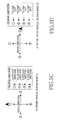
- FIG. 2C illustrates an operation for determining the direction to the route according to a relative angle of a projection direction to the route measured with respect to the heading of the vehicle.
- Four directions to the route are defined according to the relative angle of the projection direction to the route with respect to the heading of the vehicle. If the relative angle of the projection direction is 0° to 45°, the route is ahead of the vehicle. If the relative angle of the projection direction is 46° to 135°, the route is to the right of the vehicle. If the relative angle of the projection direction is 136° to 225°, the route is behind the vehicle. If the relative angle of the projection direction is 226° to 315°, the route is to the left of the vehicle.
- the route is ahead of the vehicle. For example, if the projection direction angle is 220° in azimuth and the heading of the vehicle is 315° as illustrated in FIG. 2C, subtracting 315 from 220 gives -95°, i.e., 265°. Thus, the route is to the left of the vehicle.
- FIG. 2D illustrates an operation for determining the direction the route runs with respect to the vehicle according to a relative angle of the route direction with respect to the vehicle heading.
- Four route directions are defined. If the relative route direction angle is 0° to 45°, the route runs in the same direction as the vehicle. If the relative route direction angle is 46° to 135°, the route runs to the right of the vehicle. If the relative route direction angle is 136° to 225°, the route runs in the opposite direction the vehicle is traveling. If the relative route direction angle is 226° to 315°, the route runs to the left of the vehicle. If the relative route direction angle is 316° to 359°, the route runs in the same direction as the vehicle. In the above example, subtracting the vehicle heading 315° from the route direction azimuth angle 350° gives 35° and thus the route runs in the same direction as the vehicle.
- FIGs. 9 and 10 According to a guiding mode determined by the operations illustrated in FIGs. 2A to 2D, graphical representations and voice announcements are provided as illustrated in FIGs. 9 and 10.
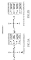
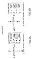
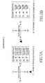
- FIGs. 3A to 5D illustrate route directions and guiding directions in the guiding modes A, B and C according to the directions to the route from the present position of the vehicle.
- FIGs. 3A to 3D illustrate route directions and guiding directions according to the directions to the route in the guiding mode A. Audible and visible route entry guidance is provided in the same manner in FIGs. 3A to 3D and thus only FIG. 3A will be described on behalf of the figures.
- FIG. 3A illustrates the case where the route is ahead of the vehicle (1). If the route runs in a direction 1 ⁇ , the controller 10 displays "12 o'clock direction” and " ⁇ " on the LCD of the display 18 and outputs a voice message "the route entry is in the 12 o'clock direction" through the voice processor 16 and the speaker SPK.
- FIGs. 4A to 4D illustrate route directions and guiding directions according to the directions to the route in the guiding mode B
- FIGs. 5A to 5D illustrate route directions and guiding directions according to the directions to the route in the guiding mode C.
- Audible and visible route entry guidance is provided in the same method as described above.
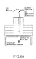
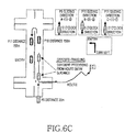
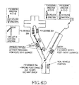
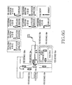
- FIGs. 6A to 6G illustrate route entry guidance under real road conditions in connection with FIGs. 3A to 3D.
- Route entry guidance in the present invention refers to guiding the vehicle to the entry to the route. If the vehicle is remote from the route, the guiding mode B or C is chosen. When the guiding mode A is chosen for the vehicle relatively near to the route, the vehicle should be guided directly to enter the route. However, if the direct guidance to the route is not available, the vehicle is guided to the route entry by changing the guiding modes under the circumstances.
- FIG. 6A illustrates route entry guidance when the guiding mode is A, the route is ahead of the vehicle, and the route runs in the same direction as the vehicle (represented by A-(1)-1 ⁇ ), and going straight is available at an intersection.
- the shortest distance to the route is below 50m, the route runs in the same direction as the vehicle, and the vehicle goes ahead at the intersection in the 12 o'clock direction.
- the vehicle enters the route easily.
- FIG. 6B illustrates route entry guidance in the case where A-(1)-1 ⁇ is chosen as a guiding mode but going straight and turning left are prohibited at the intersection.
- A-(1)-1 ⁇ is chosen as a guiding mode but going straight and turning left are prohibited at the intersection.
- the vehicle turns right at a point P1 and reaches a point P2
- the distance to the route at the point P2 is below 50m and the route behind the vehicle runs to the left of the vehicle.
- the guiding mode is changed to A-(3)-4 ⁇ .
- the guiding mode becomes B-(3)-4 ⁇ .
- the vehicle is guided to enter the route via points P4 to P8.
- FIG. 6C illustrates route entry guidance when the vehicle is in different positions when requesting route information and after downloading the route information and thus the guiding mode A-(1)-3 ⁇ is chosen instead of A-(1)-2 ⁇ . If the route is ahead of the vehicle at a point P9 and the route runs in the opposite direction the vehicle travels, the guiding mode is A-(1)-3 ⁇ , the guiding direction is the 12 o'clock direction. Then, the vehicle goes straight and enters the route via points P10 and P11 with the aid of corresponding guidance at the respective points.
- FIG. 6D illustrates route entry guidance when the real position of the vehicle is incorrectly measured at point P12 due to errors in the GPS, sensors, and a digital map.
- the guiding mode is A-(1)-3 ⁇ and thus the guiding direction is the 12 o'clock direction. If the vehicle reaches a point P13, it directly enters the route. On the other hand, if the vehicle travels in the opposite direction to the route direction and reaches a point 14, the vehicle is guided to take the 6 o'clock direction in the guiding mode A-(3)-3 ⁇ . Then, the vehicle is guided from a point P15 to enter the route in the guiding mode A-(1)-1 ⁇ .
- FIG. 6E illustrates route entry guidance when the vehicle is opposite-traveling via points P16, 17 and 18 due to errors in the GPS, sensors, and digital map but it is determined that the vehicle is traveling in parallel to the route along the opposite direction of the route, and thus the guiding mode A-(1)-3 ⁇ is chosen.
- the guiding mode is A-(4)-3 ⁇ and the vehicle is guided to take the 6 0'clock direction.
- the vehicle takes a U-turn and then enters the route at a point P19.
- FIG. 6F illustrates route entry guidance when a guiding mode A-(4)-1 ⁇ is chosen.
- the vehicle runs on a very wide road. If route information is requested at a point P20 and the route illustrated in FIG. 6F is downloaded, since the route is expressed as a line, it may be determined that the vehicle is spaced from the route by some distance even though it is on the route. Or it may be determined that the vehicle is traveling on another route in parallel to the route. This phenomenon can be worsened due to errors in the GPS, sensors, and digital map. If the vehicle is stationary at the point P20, it cannot be directly determined that the vehicle is in the route. In this case, the guiding mode is A-(4)-1 ⁇ and the vehicle is guided to take the 12 o'clock direction. After the vehicle travels for a predetermined distance, it is determined that the vehicle is in the route and then route guidance is provided.
- FIG. 6G illustrates route entry guidance when the guiding mode A-(2)-2 ⁇ is chosen.
- the guiding mode A-(4)-1 ⁇ is set and the guiding direction is the 12 o'clock direction. If the vehicle can take the 12 o'clock direction to get out of the parking lot, the route entry guidance is easily fulfilled. However, if the exit of the parking lot is located as illustrated in FIG. 6G, the vehicle should travel via points P24, 25 and 26. At the point P26, the vehicle is guided to turn left in the guiding mode A-(1)-2 ⁇ . If the driver does not turn left due to his carelessness or traffic conditions, the vehicle reaches a point P28. Here, the vehicle is not supposed to go straight in real conditions.
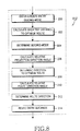
- FIG. 7 is a flowchart illustrating a route entry guiding method according to the embodiment of the present invention and FIG. 8 is a flowchart illustrating a route entry guiding routine 112 illustrated in FIG. 7 in detail.
- Step 106 is performed each time the present position of the vehicle is checked and its period can be set freely.
- the vehicle readily enters a road in a route on a digital map with the aid of route entry guidance and then receives known route guidance.
- the controller 10 enters a route entry guiding mode in step 200, determines the shortest distance to the route in step 202, and determines a guiding mode according to the distance in step 204.
- the controller 10 calculates a relative angle of a projection direction to the route with respect to the heading of the vehicle.
- the controller 10 determines the direction to the route according to the relative angle of the projection direction in step 208 and calculates a relative angle of the direction the route runs with respect to the vehicle heading in step 210.
- the controller 10 determines a route direction with respect to the present vehicle position according to the relative route direction angle in step 212 and provides route entry guidance according to the guiding mode in step 214.
- the guiding mode is changed to B-(1)-2 ⁇ and the distance to the route is 80m. "80m” is displayed on the LCD, while a voice message “Turn right 80m ahead to enter the route” is output. The driver recognizes that he is near the route and should turn right to enter the route.
- the guiding mode is set to A-(4)-1 ⁇ and the distance to the route is 45m. 45m is within an error limit range of the GPS and digital map. Since the digital map is fabricated with respect to the central lines of roads, it is determined that the vehicle is in the route. Then, " ⁇ " is displayed on the LCD, while a voice message "Go straight” is output. Thus, the driver enters the route and travels in the route direction.
- FIG. 10 illustrates another embodiment of the method of guiding a vehicle to a route entry in each guiding mode according to the present invention.
- the vehicle is guided to access the route regardless of the route direction in the guiding mode C, the vehicle is guided to turn left due to a different route direction in the guiding mode B, and the vehicle is guided to go straight, assuming that the vehicle is already in the route since the distance to the route is 45m even though the route is to the right of the vehicle in the second embodiment.
- the reason for guiding the vehicle in the manners according to the first and second embodiment of the present invention instead of notifying the distance and direction to a route using projection points to the route is that the projections points continuously vary during traveling.
- a vehicle is rapidly and easily guided to the entry to an optimum route on a digital map through a portable terminal. Therefore, the driver can drive more conveniently.
Landscapes
- Engineering & Computer Science (AREA)
- Radar, Positioning & Navigation (AREA)
- Remote Sensing (AREA)
- Physics & Mathematics (AREA)
- General Physics & Mathematics (AREA)
- Automation & Control Theory (AREA)
- Health & Medical Sciences (AREA)
- Audiology, Speech & Language Pathology (AREA)
- General Health & Medical Sciences (AREA)
- Multimedia (AREA)
- Navigation (AREA)
- Traffic Control Systems (AREA)
Applications Claiming Priority (4)
| Application Number | Priority Date | Filing Date | Title |
|---|---|---|---|
| KR20010024175 | 2001-05-03 | ||
| KR2001024175 | 2001-05-03 | ||
| KR2002021134 | 2002-04-18 | ||
| KR1020020021134A KR100353652B1 (ko) | 2001-05-03 | 2002-04-18 | 휴대용 단말기를 이용한 네비게이션 시스템에서의경로진입 안내장치 및 방법 |
Publications (2)
| Publication Number | Publication Date |
|---|---|
| EP1260953A2 true EP1260953A2 (fr) | 2002-11-27 |
| EP1260953A3 EP1260953A3 (fr) | 2006-08-02 |
Family
ID=26639048
Family Applications (1)
| Application Number | Title | Priority Date | Filing Date |
|---|---|---|---|
| EP02009962A Withdrawn EP1260953A3 (fr) | 2001-05-03 | 2002-05-03 | Système de navigation utilisant un terminal portable |
Country Status (3)
| Country | Link |
|---|---|
| US (1) | US6708111B2 (fr) |
| EP (1) | EP1260953A3 (fr) |
| CN (1) | CN1291217C (fr) |
Families Citing this family (20)
| Publication number | Priority date | Publication date | Assignee | Title |
|---|---|---|---|---|
| JPWO2003027618A1 (ja) * | 2001-09-20 | 2005-01-06 | 松下電器産業株式会社 | 案内システム、案内装置、案内装置と通信する無線装置 |
| JP2003106845A (ja) * | 2001-09-28 | 2003-04-09 | Pioneer Electronic Corp | ナビゲーションシステム、移動体ナビゲーション装置及び通信ナビゲーション装置並びに情報サーバ装置、ナビゲーション方法、移動体ナビゲーション方法及び通信ナビゲーション方法並びにサーバ処理方法、ナビゲーション用プログラム、移動体ナビゲーション用プログラム及び通信ナビゲーション用プログラム並びにサーバ処理用プログラム及び情報記録媒体 |
| TW200424963A (en) * | 2003-05-02 | 2004-11-16 | Sin Etke Technology Co Ltd | Cross country navigation system |
| ATE348997T1 (de) * | 2004-02-26 | 2007-01-15 | Cit Alcatel | Verfahren zur eingabe von zielortinformationen über ein mobiles endgerät |
| US20050221877A1 (en) * | 2004-04-05 | 2005-10-06 | Davis Scott B | Methods for controlling processing of outputs to a vehicle wireless communication interface |
| KR100694678B1 (ko) * | 2004-08-20 | 2007-03-13 | 에스케이 주식회사 | 출발지 및 목적지 안내 정보 제공 시스템과 그 방법 |
| KR101154079B1 (ko) * | 2005-02-16 | 2012-06-11 | 삼성전자주식회사 | 네비게이션 장치의 초기 위치 결정 방법 |
| US7580792B1 (en) * | 2005-10-28 | 2009-08-25 | At&T Corp. | Method and apparatus for providing traffic information associated with map requests |
| US20080039991A1 (en) * | 2006-08-10 | 2008-02-14 | May Reed R | Methods and systems for providing accurate vehicle positioning |
| AU2008204559A1 (en) * | 2007-01-10 | 2008-07-17 | Tomtom International B.V. | Navigation device and method |
| KR100946473B1 (ko) * | 2007-12-17 | 2010-03-10 | 현대자동차주식회사 | 3차원 입체 데이터의 로딩 방법 |
| JP5353291B2 (ja) * | 2009-02-19 | 2013-11-27 | ソニー株式会社 | 案内経路配信装置、案内経路配信方法及び案内経路配信プログラム |
| US8566035B2 (en) * | 2010-02-25 | 2013-10-22 | International Business Machines Corporation | Route optimization |
| JP5384545B2 (ja) * | 2011-03-07 | 2014-01-08 | 本田技研工業株式会社 | ナビシステム、ナビサーバ、ナビクライアントおよびナビ方法 |
| CN103562679B (zh) * | 2011-06-03 | 2016-08-31 | 苹果公司 | 用于打印地图和方向指引的系统和方法 |
| US9103679B2 (en) * | 2012-02-02 | 2015-08-11 | Telenav, Inc. | Navigation system with display control mechanism and method of operation thereof |
| CN107438226B (zh) * | 2016-05-25 | 2021-03-16 | 北京嘀嘀无限科技发展有限公司 | 订单发布处理方法及服务器 |
| US10043387B1 (en) | 2017-01-25 | 2018-08-07 | International Business Machines Corporation | Map display with directions generating and download facility |
| KR102521834B1 (ko) * | 2018-08-21 | 2023-04-17 | 삼성전자주식회사 | 차량으로 영상을 제공하는 방법 및 이를 위한 전자 장치 |
| CN113494920A (zh) * | 2020-03-20 | 2021-10-12 | 深圳市超捷通讯有限公司 | 导航路线规划方法、装置及存储介质 |
Family Cites Families (6)
| Publication number | Priority date | Publication date | Assignee | Title |
|---|---|---|---|---|
| US6006158A (en) * | 1993-09-07 | 1999-12-21 | H. R. Pilley | Airport guidance and safety system incorporating lighting control using GNSS compatible methods |
| US5512904A (en) * | 1994-06-13 | 1996-04-30 | Andrew Corporation | Method and apparatus of establishing a vehicle azimuth |
| JP3384172B2 (ja) * | 1995-02-28 | 2003-03-10 | 株式会社デンソー | 車両用走行案内装置 |
| DE69625142T2 (de) * | 1995-09-08 | 2003-04-24 | Aisin Aw Co., Ltd. | Fahrzeugnavigationssystem |
| KR100267543B1 (ko) * | 1996-04-28 | 2000-10-16 | 모리 하루오 | 도로정보 또는 교차점정보의 처리장치 |
| KR100263982B1 (ko) * | 1996-04-28 | 2000-08-16 | 모리 하루오 | 네비게이션장치 |
-
2002
- 2002-05-03 US US10/138,872 patent/US6708111B2/en not_active Expired - Fee Related
- 2002-05-03 EP EP02009962A patent/EP1260953A3/fr not_active Withdrawn
- 2002-05-08 CN CNB021410151A patent/CN1291217C/zh not_active Expired - Fee Related
Also Published As
| Publication number | Publication date |
|---|---|
| US20020165664A1 (en) | 2002-11-07 |
| EP1260953A3 (fr) | 2006-08-02 |
| US6708111B2 (en) | 2004-03-16 |
| CN1291217C (zh) | 2006-12-20 |
| CN1385674A (zh) | 2002-12-18 |
Similar Documents
| Publication | Publication Date | Title |
|---|---|---|
| US6708111B2 (en) | Route entry guiding device and method in a navigation system using a portable terminal | |
| EP1317742B1 (fr) | Systeme de navigation mettant en oeuvre un reseau de communication sans fil ainsi qu'un procede de guidage routier associe | |
| US9026150B2 (en) | Mobile Tracking | |
| US7532975B2 (en) | Imaging apparatus for vehicles | |
| US7308359B1 (en) | Navigation system, method and device with automatic next turn page | |
| KR100594144B1 (ko) | 이미지 데이터를 이용한 텔레매틱스 시스템 및 그의 경로안내방법 | |
| US5504482A (en) | Automobile navigation guidance, control and safety system | |
| CA2645762C (fr) | Poursuite d'appareil mobile | |
| US6901330B1 (en) | Navigation system, method and device with voice guidance | |
| EP1233251A2 (fr) | Système de navigation | |
| EP2703780A2 (fr) | Appareil de navigation et son procédé dýaffichage | |
| US6760662B2 (en) | Route guiding method for in-vehicle navigation device | |
| JP4405449B2 (ja) | ナビゲーションシステム、地図表示装置および地図表示方法 | |
| JP2002131067A (ja) | ナビゲーション装置、基地局装置及びこれらを用いた道路交通情報システム | |
| JP2007071665A (ja) | ナビゲーションシステム | |
| JP3368775B2 (ja) | 車載用ナビゲーション装置 | |
| JP2001074486A (ja) | ナビゲーション装置 | |
| KR100353652B1 (ko) | 휴대용 단말기를 이용한 네비게이션 시스템에서의경로진입 안내장치 및 방법 | |
| KR20020096751A (ko) | 위치 정보를 이용한 파노라마 영상 제공 방법 | |
| KR20040031466A (ko) | 이동단말을 이용한 네비게이션 시스템에서의 교차로경로안내방법 | |
| JP2005345429A (ja) | 走行車線案内装置 | |
| JP3176106B2 (ja) | 車両用走行誘導装置 | |
| KR20070042816A (ko) | 실시간 교통정보 제공 시스템 및 방법 | |
| JPH06274795A (ja) | ナビゲーションシステム | |
| JPH03226623A (ja) | 車両用ナビゲーション装置 |
Legal Events
| Date | Code | Title | Description |
|---|---|---|---|
| PUAI | Public reference made under article 153(3) epc to a published international application that has entered the european phase |
Free format text: ORIGINAL CODE: 0009012 |
|
| 17P | Request for examination filed |
Effective date: 20020503 |
|
| AK | Designated contracting states |
Kind code of ref document: A2 Designated state(s): AT BE CH CY DE DK ES FI FR GB GR IE IT LI LU MC NL PT SE TR |
|
| AX | Request for extension of the european patent |
Free format text: AL;LT;LV;MK;RO;SI |
|
| PUAL | Search report despatched |
Free format text: ORIGINAL CODE: 0009013 |
|
| AK | Designated contracting states |
Kind code of ref document: A3 Designated state(s): AT BE CH CY DE DK ES FI FR GB GR IE IT LI LU MC NL PT SE TR |
|
| AX | Request for extension of the european patent |
Extension state: AL LT LV MK RO SI |
|
| 17Q | First examination report despatched |
Effective date: 20070226 |
|
| AKX | Designation fees paid |
Designated state(s): DE FR GB |
|
| RAP1 | Party data changed (applicant data changed or rights of an application transferred) |
Owner name: SAMSUNG ELECTRONICS CO., LTD. |
|
| STAA | Information on the status of an ep patent application or granted ep patent |
Free format text: STATUS: THE APPLICATION IS DEEMED TO BE WITHDRAWN |
|
| 18D | Application deemed to be withdrawn |
Effective date: 20141202 |