EP1411450A2 - Méthode, appareil et programme d'ordinateur pour déterminer une structure de graphe pour la caractérisation d'une surface avec un trou et des obstacles - Google Patents
Méthode, appareil et programme d'ordinateur pour déterminer une structure de graphe pour la caractérisation d'une surface avec un trou et des obstacles Download PDFInfo
- Publication number
- EP1411450A2 EP1411450A2 EP03103550A EP03103550A EP1411450A2 EP 1411450 A2 EP1411450 A2 EP 1411450A2 EP 03103550 A EP03103550 A EP 03103550A EP 03103550 A EP03103550 A EP 03103550A EP 1411450 A2 EP1411450 A2 EP 1411450A2
- Authority
- EP
- European Patent Office
- Prior art keywords
- graph structure
- area
- distance information
- topological
- obstacles
- Prior art date
- Legal status (The legal status is an assumption and is not a legal conclusion. Google has not performed a legal analysis and makes no representation as to the accuracy of the status listed.)
- Withdrawn
Links
Images

Classifications
-
- G—PHYSICS
- G05—CONTROLLING; REGULATING
- G05D—SYSTEMS FOR CONTROLLING OR REGULATING NON-ELECTRIC VARIABLES
- G05D1/00—Control of position, course, altitude or attitude of land, water, air or space vehicles, e.g. using automatic pilots
- G05D1/02—Control of position or course in two dimensions
- G05D1/021—Control of position or course in two dimensions specially adapted to land vehicles
- G05D1/0268—Control of position or course in two dimensions specially adapted to land vehicles using internal positioning means
- G05D1/0274—Control of position or course in two dimensions specially adapted to land vehicles using internal positioning means using mapping information stored in a memory device
-
- G—PHYSICS
- G06—COMPUTING OR CALCULATING; COUNTING
- G06F—ELECTRIC DIGITAL DATA PROCESSING
- G06F30/00—Computer-aided design [CAD]
Definitions
- the invention relates to a determination of a graph structure to describe an area with an open area and obstacles.
- Efficient processing of the area by the service robot assumes that the surface treatment device is as possible covers the entire area to be processed, where possible few routes can be driven twice.
- Path planning procedures in general require knowledge of the geometric conditions of the surface to be processed ahead. This includes, for example, information about dimensions the area and layers and dimensions to be processed obstacles present in it.
- geometric maps are used, in which the respective geometric conditions of a area to be processed are saved.
- Such a digital, geometric map can with appropriate Previous knowledge created in advance and in a service robot be saved.
- the path planning procedure or the path planning can be carried out in advance.
- the one to leave Path is known at the beginning of surface processing.
- a digital, geometric map can only be used during a Surface processing can be created dynamically. In this case, the path planning takes place during the surface processing.
- Path planning method based on these geometric maps are also known. The following are examples called different path planning methods.
- Maps also as a basis for determining a current position or location of a mobile Robot in a surface (position estimation). This will referred to as localization or global localization. Of such geometric maps are also used for orientation and navigation of the robot in a surface.
- topological maps are used to describe one Area a graph or a graph structure, which or which is usually formed from a coherent Sequence of nodes and edges.
- topologically used or “topological” graphs or graphene structures are known, for example, so-called Voronoi graphs (VG) or generalized Voronio graphs (GVG) [8], [9], [10] as well as so-called “medial axis” [1], [8].
- VG Voronoi graphs
- GVG generalized Voronio graphs
- the "medial axis" are formed by the locations or the set of circle centers of all maximally large ones Circles that lie completely in a closed area and touch at least twice.
- the free areas are described by the graphs structural and not metric, i.e. more precise geometric Information about the area, such as distances or dimensions to the graphs are usually not obstacles removable.
- topological graphs such as Voronoi graphs are suitable or medial axis, only limited for localization or global localization, orientation or navigation of a mobile robot.
- shock graph is known from [1], which there for image processing or object detection structural description of closed with outline Surfaces and shapes are used.
- the invention has for its object a description an area with open spaces and obstacles which is easy to identify and present, and requires little storage space. In addition, it should but contain enough information to help localize it or relocation, orientation or navigation of a mobile Robot to be usable.
- This task is accomplished through the procedure and arrangement as well through the computer program with program code means and the computer program product for determining a graph structure to describe an area with an open area and obstacles with the features according to the respective independent Claim resolved.
- the invention is clearly seen in contrast to known digital, geometric maps, each of which the entire area with all obstacles saved only the shape and topology of an open space of the surface in more efficient form, in this case using a topological used or "topological” graphs or graph structure, like a shock graph, one "medial axis” or a Voronoi graph.
- topological graphs or graph structures are further enriched by suitable distance information (annotated), which, for example, leads to so-called annotated media axis leads.
- the distance information contains such Information that makes it possible, together with the graph structure Reproduce obstacles of the surface.
- the computer program with program code means is set up all steps according to the inventive method perform when the program is running on a computer becomes.
- the computer program product with on a machine readable Carrier stored program code means is set up all steps according to the inventive method perform when the program is running on a computer becomes.
- the arrangement and the computer program with program code means, set up around all steps according to the inventive Procedure when the program is on a Computer is running, as well as the computer program product with program code means stored on a machine-readable medium, set up for all steps according to the perform inventive method when the program is on running a computer are particularly suitable to carry out the method according to the invention or a his further training explained below.
- a computer program product which has a storage medium on which the Computer program is stored with program code means, which carries out the invention or the training.
- Shock graphs can be used to form the topological graph structure [1] or a "medial axis" [1], [8] or Voronoi graph [8], [9], [10] and corresponding procedures for Formation of the graph types mentioned as examples become.
- the graphs generated usually have one Sequence of nodes and edges on.
- the distance information is to be chosen so that using the graph structure enriched with the distance information the obstacles of the surface, which are usually with a Boundary of the open space at least partially agree, can be determined or reconstructed. It is useful, for example, if the distance information is a size and / or Describes the shape of the open space, for example by specifying it of distances between elements, i.e. Knots or edges, the topological graph structure and the obstacles or the boundaries of the open spaces.
- the distances or a corresponding distance information can be measured by sensor-based distance measurements, such as laser, Ultrasound measurements or measurements by video systems become.
- the distance information can also be formed using of circle radii of circles, their circle centers at least partially form the topological graph structure. This is particularly useful if the topological Graphene structure using shock graphs [1], "medial axis "[1], [8] or Voronoi graphs [8], [9], [10] or appropriate procedure is formed.
- topological Graph structure with the distance information can be easily if the distance information is numerically coded or color-coded the topological graph structure is assigned.
- the elements namely the nodes and edges
- the topological Graph structure can be assigned.
- a description content of the graph structure can be further increased if the topological graph structure with another Information, in particular curvature information, enriched or annotated.
- curvature information For example, a course of an edge of the topological graph structure. Can too the topological graph structure through optical information, like optical impressions of a camera.
- the topological graph structure can also be used a geometric map of the area, especially a local one geometric grid map, and / or using of distance measurements generating sensor measurements, especially laser / ultrasonic measurements or measurements by Video systems.
- the invention is particularly useful for building large, global ones Area descriptions, i.e. accordingly structured Cards, insert.
- This structured map of the total area can now continue or the overall graph structure for a localization, for example a mobile unit, which is in one Part of the total area is moved or stopped.
- the corresponding one Graphene structure determined according to the invention For this part or part of the area is the corresponding one Graphene structure determined according to the invention. Subsequently becomes the graph structure of the sub-area with the overall graph structure compared and that of the graph structure of the Subgraph corresponding subgraph structure in the overall graph structure certainly. Using the subgraph structure or the mobile unit can determine their position in the overall graph structure be localized.
- the invention can be used in particular are used in mobile units, such as mobile robots. You can NEN using the procedure according to the invention Tasks for mobile units, such as localization, orientation and / or path planning tasks can be solved.
- the mobile unit is used localizes the graphene structure according to the invention and / or navigated using this.
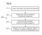
- method steps 810 to 840 are shown in localization of an autonomous, mobile robot in one Total area using one with distance information annotated overall graph or one with distance information annotated "medial axis" is shown.
- the mobile robot in the execution case a cleaning robot, is equipped with a cleaning device, several laser scanners, sensors for measuring distances and distances as well as a computing or evaluation unit.
- the total area 500 (see FIG. 5), one in the execution case cleaning surface, is limited on all sides by walls 501 and obstacles 502 placed on walls 501, such as Cupboards and shelves. There are also 500 more in the total area various obstacles 503, which in the Cleaning by the mobile robot must be observed.
- the further evaluation of the images also includes the following described localization method 800 according to FIG the process steps 810 to 840 together with the figures 1 to 7.
- Method step 1) Constant construction of a local geometric grid map of an environment (810; Fig.1)
- FIG. 1 shows a local geometric grid map 100 of the local, i.e. closer, environment of the mobile robot 110 and thus a local section of the total area.
- a such local geometric grid map 100 is constantly in use a trip of the mobile robot 110 created or set up and saved.
- the mobile robot 100 "scans" while it is traveling by means of its laser scanners constantly creates the environment Surrounding images and creates the local, geometric Grid cards.
- Moving objects such as people, may be recognized and filtered out.
- the sensors measure distances and distances determined to the walls 121 and obstacles 122 and these are integrated into the local geometric grid maps 100.
- the local geometric grid map 100 shown in FIG. 1 in this case shows a passage 120 which is limited by walls 121 and obstacles 122. Not obstacles blocked areas are also known as open spaces.
- Method step 2) Construction of a local graph enriched with distance information (local, annotated medial a-xis, Fig. 1 and Fig. 2)
- a non-annotated “medial axis” is determined. Corresponding procedures for determining an unannoted “medial axis” are described in [1], [8].
- the generated a medial axis that is not annotated has a sequence from nodes 130, 230 and edges 131, 231.
- each node 130, 230 and each edge 131, 231 the distance to the nearest distant object, i.e. to the nearest farthest Obstacle 122, 222 or to the nearest distant wall 121, 221 is assigned. This will make the one that is not annotated at first "medial axis" annotated and thus around the decency information enriched.
- Numerical distance values or distances are assigned, where to illustrate the annotated "medial axis" these according to the respective assigned distance values in the local geometric grid map 100, 200 color-coded is pictured.
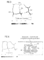
- Method step 3 Fusion of local annotated graphs into a global, annotated graph structure (Fig. 3 and Fig. 4)
- new parts of a local, annotated graph are created 324, 401 on the global, annotated environment graph 325, 400 added and / or parts of the global, annotated environment graph 325, 400 by parts of a local, annotated Graphs 324, 401 replaced.
- Method step 4 Finding a local, annotated graph or a part of the same graph in the global, annotated graph structure
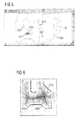
- FIG 5 shows the mobile robot 510 on one not for him known position 520 in the total area 500.
- the mobile creates at this unknown position 520 Robot 510 according to the known and described procedure the corresponding local, annotated graph 600 (Fig.6).
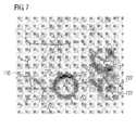
- the task in determining the position is now the local, annotated one Graph 600 or a part of the graph in the global, annotated graph structure 800 (FIG. 8).
- a node 610 selected in the local, annotated graph 600 is sent to the local, annotated graph 600 additionally the minimum obstacle distance can be taken from this node 610.
- annotated environment graph 700 initially Node 710 with comparable minimum obstacle distance selected and this according to their minimum Obstacle distance sorted.
- the selected nodes 710 become corresponding their sorting with the node 610 to be located compared, with further geometric information in the Comparison.
- a "Constraint Propagation" or “Relaxation” an assignment selected for which not only the individual nodes fit, but also their relative structure.
- the selected node becomes 610 - and thus the local, annotated Graph 600 as well as the mobile robot - localized in the global, annotated environment graph 700 and thus the unknown position 520 of the robot certainly.
Landscapes
- Engineering & Computer Science (AREA)
- Physics & Mathematics (AREA)
- General Physics & Mathematics (AREA)
- Radar, Positioning & Navigation (AREA)
- Theoretical Computer Science (AREA)
- Evolutionary Computation (AREA)
- General Engineering & Computer Science (AREA)
- Geometry (AREA)
- Computer Hardware Design (AREA)
- Aviation & Aerospace Engineering (AREA)
- Remote Sensing (AREA)
- Automation & Control Theory (AREA)
- Management, Administration, Business Operations System, And Electronic Commerce (AREA)
- Control Of Position, Course, Altitude, Or Attitude Of Moving Bodies (AREA)
Applications Claiming Priority (2)
| Application Number | Priority Date | Filing Date | Title |
|---|---|---|---|
| DE10247772 | 2002-10-14 | ||
| DE10247772 | 2002-10-14 |
Publications (2)
| Publication Number | Publication Date |
|---|---|
| EP1411450A2 true EP1411450A2 (fr) | 2004-04-21 |
| EP1411450A3 EP1411450A3 (fr) | 2006-06-14 |
Family
ID=32038623
Family Applications (1)
| Application Number | Title | Priority Date | Filing Date |
|---|---|---|---|
| EP03103550A Withdrawn EP1411450A3 (fr) | 2002-10-14 | 2003-09-25 | Méthode, appareil et programme d'ordinateur pour déterminer une structure de graphe pour la caractérisation d'une surface avec un trou et des obstacles |
Country Status (1)
| Country | Link |
|---|---|
| EP (1) | EP1411450A3 (fr) |
Cited By (4)
| Publication number | Priority date | Publication date | Assignee | Title |
|---|---|---|---|---|
| US7765499B2 (en) | 2002-10-23 | 2010-07-27 | Siemens Aktiengesellschaft | Method, system, and computer product for forming a graph structure that describes free and occupied areas |
| WO2018135988A1 (fr) * | 2017-01-19 | 2018-07-26 | Husqvarna Ab | Programme de travail amélioré pour tondeuse à gazon robotisée |
| CN110809787A (zh) * | 2018-07-19 | 2020-02-18 | 深圳市大疆创新科技有限公司 | 地图构建方法、可移动平台及计算机可读存储介质 |
| US11089732B2 (en) | 2017-01-11 | 2021-08-17 | Husqvarna Ab | Collision detection for a robotic work tool |
-
2003
- 2003-09-25 EP EP03103550A patent/EP1411450A3/fr not_active Withdrawn
Non-Patent Citations (1)
| Title |
|---|
| None |
Cited By (5)
| Publication number | Priority date | Publication date | Assignee | Title |
|---|---|---|---|---|
| US7765499B2 (en) | 2002-10-23 | 2010-07-27 | Siemens Aktiengesellschaft | Method, system, and computer product for forming a graph structure that describes free and occupied areas |
| US8286122B2 (en) | 2002-10-23 | 2012-10-09 | Siemens Aktiengesellschaft | Method, system, and computer product for forming a graph structure that describes free and occupied areas |
| US11089732B2 (en) | 2017-01-11 | 2021-08-17 | Husqvarna Ab | Collision detection for a robotic work tool |
| WO2018135988A1 (fr) * | 2017-01-19 | 2018-07-26 | Husqvarna Ab | Programme de travail amélioré pour tondeuse à gazon robotisée |
| CN110809787A (zh) * | 2018-07-19 | 2020-02-18 | 深圳市大疆创新科技有限公司 | 地图构建方法、可移动平台及计算机可读存储介质 |
Also Published As
| Publication number | Publication date |
|---|---|
| EP1411450A3 (fr) | 2006-06-14 |
Similar Documents
| Publication | Publication Date | Title |
|---|---|---|
| EP1554639B1 (fr) | Procede, dispositif et programme informatique comprenant des systemes de codes de programmation et un produit de programme informatique, pour constituer une structure graphique destinee a decrire une surface comprenant une surface libre et une surface occupee | |
| EP3814067B1 (fr) | Exploration d'une zone d'intervention d'un robot par un robot mobile autonome | |
| DE102013208521B4 (de) | Kollektives Erlernen eines hochgenauen Straßenmodells | |
| DE102015119865B4 (de) | Robotergestützte Bearbeitung einer Oberfläche mittels eines Roboters | |
| EP3709853A1 (fr) | Traitement du sol au moyen d'un robot mobile autonome | |
| EP2812766B2 (fr) | Procédé de déclenchement automatique d'une auto-localisation | |
| DE3853616T2 (de) | Verfahren und Gerät zur Wegplanung. | |
| EP1105782A2 (fr) | Procede et dispositif pour la determination d'une course autour d'une position de reference predeterminee | |
| EP3676680A1 (fr) | Planification de déplacement pour robot mobile autonome | |
| DE102012112036B4 (de) | Selbstfahrendes Bodenbearbeitungsgerät und Verfahren zur Navigation bei einem selbstfahrenden Bodenbearbeitungsgerät | |
| DE102015006014A1 (de) | Bodenbearbeitungsgerät und Verfahren zu dessen Navigation sowie Schwarm von Bodenbearbeitungsgeräten und Verfahren zu deren gemeinsamer Navigation | |
| WO2021156000A1 (fr) | Procédé pour faire fonctionner une installation technique | |
| DE102009047407A1 (de) | Verfahren und Navigationsgerät zur Vereinfachung einer Beschreibung einer Fahrtroute | |
| DE112021003271T5 (de) | Informationsverarbeitungseinrichtung, informationsverarbeitungsverfahren und informationsverarbeitungsprogramm | |
| DE112011105210B4 (de) | Ortskurvenkorrekturverfahren, Ortskurvenkorrekturvorrichtung und mobiles Objektgerät | |
| EP0635773B1 (fr) | Procédé d'établissement d'une carte de l'environnement et de détermination d'une position dans l'environnement au moyen d'un appareil automoteur | |
| EP3875909B1 (fr) | Création d'une nouvelle carte de navigation hybride | |
| DE19957366C1 (de) | Verfahren zur Festlegung von Meßpositionen und Verfahren zur Planung von Meßbahnen für die Vermessung eines Objektes oder eines Teiles davon sowie Verfahren und Vorrichtung zur Vermessung eines Objektes oder eines Teiles davon | |
| EP1468341B1 (fr) | Procede, dispositif et programme informatique comprenant des moyens de codage de programmes et produit programme d'ordinateur permettant de planifier des trajectoires respectivement constituees de plusieurs trajectoires partielles pour une unite mobile sur une surface totale | |
| DE68921857T2 (de) | Methode und Vorrichtung zur Steuerung der Fortbewegungsrichtung eines Fahrzeuges und mit so einer Vorrichtung ausgestattetes Fahrzeug. | |
| EP1145086B1 (fr) | Procede et dispositif pour la determination d'une mesure de la similitude entre une premiere structure et au moins une seconde structure predeterminee | |
| DE102013008383B4 (de) | Korridorbasierte Routenberechnung | |
| DE102022207651B4 (de) | Erstellen eines logischen Wegenetzes in Parkräumen | |
| EP2741161B1 (fr) | Appareil autonome de traitement de surface et procédé de détection de la position de cet appareil | |
| DE102021207418A1 (de) | Verfahren zum Ausdünnen eines SLAM-Graphen, Verfahren zum Betrieb eines mobilen Geräts und mobiles Gerät |
Legal Events
| Date | Code | Title | Description |
|---|---|---|---|
| PUAI | Public reference made under article 153(3) epc to a published international application that has entered the european phase |
Free format text: ORIGINAL CODE: 0009012 |
|
| AK | Designated contracting states |
Kind code of ref document: A2 Designated state(s): AT BE BG CH CY CZ DE DK EE ES FI FR GB GR HU IE IT LI LU MC NL PT RO SE SI SK TR |
|
| AX | Request for extension of the european patent |
Extension state: AL LT LV MK |
|
| RIC1 | Information provided on ipc code assigned before grant |
Ipc: B25J 9/16 20060101ALI20060213BHEP Ipc: G06F 17/50 20060101AFI20031229BHEP |
|
| PUAL | Search report despatched |
Free format text: ORIGINAL CODE: 0009013 |
|
| AK | Designated contracting states |
Kind code of ref document: A3 Designated state(s): AT BE BG CH CY CZ DE DK EE ES FI FR GB GR HU IE IT LI LU MC NL PT RO SE SI SK TR |
|
| AX | Request for extension of the european patent |
Extension state: AL LT LV MK |
|
| 17P | Request for examination filed |
Effective date: 20061206 |
|
| AKX | Designation fees paid |
Designated state(s): AT BE BG CH CY CZ DE DK EE ES FI FR GB GR HU IE IT LI LU MC NL PT RO SE SI SK TR |
|
| 17Q | First examination report despatched |
Effective date: 20070208 |
|
| RAP1 | Party data changed (applicant data changed or rights of an application transferred) |
Owner name: SIEMENS AKTIENGESELLSCHAFT |
|
| RAP1 | Party data changed (applicant data changed or rights of an application transferred) |
Owner name: SIEMENS AKTIENGESELLSCHAFT |
|
| STAA | Information on the status of an ep patent application or granted ep patent |
Free format text: STATUS: THE APPLICATION IS DEEMED TO BE WITHDRAWN |
|
| 18D | Application deemed to be withdrawn |
Effective date: 20150401 |