EP3663719B1 - Procédé de fourniture de données de carte dans un véhicule automobile, véhicule automobile et dispositif central de traitement des données - Google Patents
Procédé de fourniture de données de carte dans un véhicule automobile, véhicule automobile et dispositif central de traitement des données Download PDFInfo
- Publication number
- EP3663719B1 EP3663719B1 EP19207417.7A EP19207417A EP3663719B1 EP 3663719 B1 EP3663719 B1 EP 3663719B1 EP 19207417 A EP19207417 A EP 19207417A EP 3663719 B1 EP3663719 B1 EP 3663719B1
- Authority
- EP
- European Patent Office
- Prior art keywords
- data
- motor vehicle
- people
- route
- depending
- Prior art date
- Legal status (The legal status is an assumption and is not a legal conclusion. Google has not performed a legal analysis and makes no representation as to the accuracy of the status listed.)
- Active
Links
Images

Classifications
-
- G—PHYSICS
- G01—MEASURING; TESTING
- G01C—MEASURING DISTANCES, LEVELS OR BEARINGS; SURVEYING; NAVIGATION; GYROSCOPIC INSTRUMENTS; PHOTOGRAMMETRY OR VIDEOGRAMMETRY
- G01C21/00—Navigation; Navigational instruments not provided for in groups G01C1/00 - G01C19/00
- G01C21/26—Navigation; Navigational instruments not provided for in groups G01C1/00 - G01C19/00 specially adapted for navigation in a road network
- G01C21/34—Route searching; Route guidance
- G01C21/36—Input/output arrangements for on-board computers
- G01C21/3602—Input other than that of destination using image analysis, e.g. detection of road signs, lanes, buildings, real preceding vehicles using a camera
-
- G—PHYSICS
- G08—SIGNALLING
- G08G—TRAFFIC CONTROL SYSTEMS
- G08G1/00—Traffic control systems for road vehicles
- G08G1/09—Arrangements for giving variable traffic instructions
- G08G1/0962—Arrangements for giving variable traffic instructions having an indicator mounted inside the vehicle, e.g. giving voice messages
- G08G1/0967—Systems involving transmission of highway information, e.g. weather, speed limits
- G08G1/096766—Systems involving transmission of highway information, e.g. weather, speed limits where the system is characterised by the origin of the information transmission
- G08G1/096791—Systems involving transmission of highway information, e.g. weather, speed limits where the system is characterised by the origin of the information transmission where the origin of the information is another vehicle
-
- G—PHYSICS
- G01—MEASURING; TESTING
- G01C—MEASURING DISTANCES, LEVELS OR BEARINGS; SURVEYING; NAVIGATION; GYROSCOPIC INSTRUMENTS; PHOTOGRAMMETRY OR VIDEOGRAMMETRY
- G01C21/00—Navigation; Navigational instruments not provided for in groups G01C1/00 - G01C19/00
- G01C21/26—Navigation; Navigational instruments not provided for in groups G01C1/00 - G01C19/00 specially adapted for navigation in a road network
- G01C21/34—Route searching; Route guidance
- G01C21/3407—Route searching; Route guidance specially adapted for specific applications
- G01C21/343—Calculating itineraries
-
- G—PHYSICS
- G01—MEASURING; TESTING
- G01C—MEASURING DISTANCES, LEVELS OR BEARINGS; SURVEYING; NAVIGATION; GYROSCOPIC INSTRUMENTS; PHOTOGRAMMETRY OR VIDEOGRAMMETRY
- G01C21/00—Navigation; Navigational instruments not provided for in groups G01C1/00 - G01C19/00
- G01C21/38—Electronic maps specially adapted for navigation; Updating thereof
- G01C21/3804—Creation or updating of map data
- G01C21/3807—Creation or updating of map data characterised by the type of data
- G01C21/3815—Road data
-
- G—PHYSICS
- G01—MEASURING; TESTING
- G01C—MEASURING DISTANCES, LEVELS OR BEARINGS; SURVEYING; NAVIGATION; GYROSCOPIC INSTRUMENTS; PHOTOGRAMMETRY OR VIDEOGRAMMETRY
- G01C21/00—Navigation; Navigational instruments not provided for in groups G01C1/00 - G01C19/00
- G01C21/38—Electronic maps specially adapted for navigation; Updating thereof
- G01C21/3804—Creation or updating of map data
- G01C21/3833—Creation or updating of map data characterised by the source of data
- G01C21/3841—Data obtained from two or more sources, e.g. probe vehicles
-
- G—PHYSICS
- G01—MEASURING; TESTING
- G01C—MEASURING DISTANCES, LEVELS OR BEARINGS; SURVEYING; NAVIGATION; GYROSCOPIC INSTRUMENTS; PHOTOGRAMMETRY OR VIDEOGRAMMETRY
- G01C21/00—Navigation; Navigational instruments not provided for in groups G01C1/00 - G01C19/00
- G01C21/38—Electronic maps specially adapted for navigation; Updating thereof
- G01C21/3804—Creation or updating of map data
- G01C21/3833—Creation or updating of map data characterised by the source of data
- G01C21/3848—Data obtained from both position sensors and additional sensors
-
- G—PHYSICS
- G01—MEASURING; TESTING
- G01C—MEASURING DISTANCES, LEVELS OR BEARINGS; SURVEYING; NAVIGATION; GYROSCOPIC INSTRUMENTS; PHOTOGRAMMETRY OR VIDEOGRAMMETRY
- G01C21/00—Navigation; Navigational instruments not provided for in groups G01C1/00 - G01C19/00
- G01C21/38—Electronic maps specially adapted for navigation; Updating thereof
- G01C21/3885—Transmission of map data to client devices; Reception of map data by client devices
- G01C21/3889—Transmission of selected map data, e.g. depending on route
-
- G—PHYSICS
- G06—COMPUTING OR CALCULATING; COUNTING
- G06Q—INFORMATION AND COMMUNICATION TECHNOLOGY [ICT] SPECIALLY ADAPTED FOR ADMINISTRATIVE, COMMERCIAL, FINANCIAL, MANAGERIAL OR SUPERVISORY PURPOSES; SYSTEMS OR METHODS SPECIALLY ADAPTED FOR ADMINISTRATIVE, COMMERCIAL, FINANCIAL, MANAGERIAL OR SUPERVISORY PURPOSES, NOT OTHERWISE PROVIDED FOR
- G06Q50/00—Information and communication technology [ICT] specially adapted for implementation of business processes of specific business sectors, e.g. utilities or tourism
- G06Q50/40—Business processes related to the transportation industry
-
- G—PHYSICS
- G06—COMPUTING OR CALCULATING; COUNTING
- G06V—IMAGE OR VIDEO RECOGNITION OR UNDERSTANDING
- G06V20/00—Scenes; Scene-specific elements
- G06V20/50—Context or environment of the image
- G06V20/56—Context or environment of the image exterior to a vehicle by using sensors mounted on the vehicle
- G06V20/58—Recognition of moving objects or obstacles, e.g. vehicles or pedestrians; Recognition of traffic objects, e.g. traffic signs, traffic lights or roads
-
- G—PHYSICS
- G06—COMPUTING OR CALCULATING; COUNTING
- G06V—IMAGE OR VIDEO RECOGNITION OR UNDERSTANDING
- G06V40/00—Recognition of biometric, human-related or animal-related patterns in image or video data
- G06V40/10—Human or animal bodies, e.g. vehicle occupants or pedestrians; Body parts, e.g. hands
- G06V40/103—Static body considered as a whole, e.g. static pedestrian or occupant recognition
-
- G—PHYSICS
- G08—SIGNALLING
- G08G—TRAFFIC CONTROL SYSTEMS
- G08G1/00—Traffic control systems for road vehicles
- G08G1/01—Detecting movement of traffic to be counted or controlled
- G08G1/0104—Measuring and analyzing of parameters relative to traffic conditions
- G08G1/0108—Measuring and analyzing of parameters relative to traffic conditions based on the source of data
- G08G1/0112—Measuring and analyzing of parameters relative to traffic conditions based on the source of data from the vehicle, e.g. floating car data [FCD]
-
- G—PHYSICS
- G08—SIGNALLING
- G08G—TRAFFIC CONTROL SYSTEMS
- G08G1/00—Traffic control systems for road vehicles
- G08G1/09—Arrangements for giving variable traffic instructions
- G08G1/0962—Arrangements for giving variable traffic instructions having an indicator mounted inside the vehicle, e.g. giving voice messages
- G08G1/0967—Systems involving transmission of highway information, e.g. weather, speed limits
- G08G1/096708—Systems involving transmission of highway information, e.g. weather, speed limits where the received information might be used to generate an automatic action on the vehicle control
-
- G—PHYSICS
- G08—SIGNALLING
- G08G—TRAFFIC CONTROL SYSTEMS
- G08G1/00—Traffic control systems for road vehicles
- G08G1/09—Arrangements for giving variable traffic instructions
- G08G1/0962—Arrangements for giving variable traffic instructions having an indicator mounted inside the vehicle, e.g. giving voice messages
- G08G1/0968—Systems involving transmission of navigation instructions to the vehicle
- G08G1/0969—Systems involving transmission of navigation instructions to the vehicle having a display in the form of a map
-
- G—PHYSICS
- G08—SIGNALLING
- G08G—TRAFFIC CONTROL SYSTEMS
- G08G1/00—Traffic control systems for road vehicles
- G08G1/16—Anti-collision systems
- G08G1/161—Decentralised systems, e.g. inter-vehicle communication
- G08G1/163—Decentralised systems, e.g. inter-vehicle communication involving continuous checking
-
- G—PHYSICS
- G08—SIGNALLING
- G08G—TRAFFIC CONTROL SYSTEMS
- G08G1/00—Traffic control systems for road vehicles
- G08G1/16—Anti-collision systems
- G08G1/166—Anti-collision systems for active traffic, e.g. moving vehicles, pedestrians, bikes
Definitions
- the invention relates to a method for providing map data in a motor vehicle.
- the invention also includes a motor vehicle and a central data processing device.
- Digital maps known from the state of the art typically include structural traffic routes, such as roads or cycle paths. As motor vehicles become increasingly automated, the accuracy and reliability of such map data is becoming increasingly important. Nevertheless, reliable and accurate map data is also relevant for drivers of non-autonomous motor vehicles. It would therefore be desirable to be able to provide the most reliable and accurate map data possible in a motor vehicle.
- the US 2017/0124476 A1 deals with the detection and classification of surrounding objects, in particular other road users such as pedestrians. Furthermore, by linking sensor data, for example pedestrian detection, with environmental information, such as a nearby concert hall, it is possible to deduce the future movement of such pedestrians. An optimal trajectory of the motor vehicle can then be determined. Although knowledge of the probable movement of pedestrians is also beneficial in terms of road safety, it cannot provide a more reliable or more accurate provision of map data in motor vehicles.
- the JP 2009083815 A deals with the precise recording of positions of pedestrians and other vehicles in an area before and after a traffic accident caused by one's own vehicle.
- a tachograph device is used for this purpose.
- the object of the present invention is to provide a method for providing map data in a motor vehicle, a motor vehicle and a central data processing device, by means of which road safety can be increased.
- position data recorded by a plurality of second motor vehicles relating to persons recorded by the second motor vehicles in an environment of the respective second motor vehicles are transmitted to a central data processing device.
- the central data processing device By means of the central data processing device, at least one route is determined depending on the aggregated position data, which was at least partially used by at least some of the persons, and route data of the determined at least one route is provided as part of the map data in the first motor vehicle.
- the invention is based on the realization that knowledge of paths that are typically used by people, such as pedestrians, is particularly relevant to safety. However, particularly in connection with such pedestrian paths or cycle paths, it often happens that such paths typically used by people deviate greatly from the paths actually provided for in the structure and shown on maps, such as designated pedestrian paths. However, collected swarm data that contain information about the actual positions of such people are particularly well suited to determining the paths actually used by people in an accurate and reliable manner. These can then advantageously be provided as part of map data in a motor vehicle, in this case the first motor vehicle. In general, the first motor vehicle can also represent one of the second motor vehicles or can be different from the second motor vehicles.
- Stopping points for pedestrians and/or cyclists in particular are particularly relevant, since they typically represent areas where the paths of people cross other traffic routes such as roads. For example, such stopping points are typically located at the beginning of a zebra crossing or at a pedestrian traffic light, at the beginning of a pedestrian crossing leading across the road or at the end of a pedestrian path interrupted by a cross street, etc. Many people, especially pedestrians and/or cyclists, typically gather at such stopping points, so that such stopping points pose a particularly high safety risk and a great deal of caution is required in such areas.
- stopping points are therefore particularly advantageous, since they can be taken into account by various driver assistance systems of the motor vehicle or by the driver himself, which in turn can increase safety. It is also advantageous if movement data of the people is determined depending on the recorded position data and the at least one stopping point is determined depending on the movement data. Since such stopping points typically represent points, areas or lines at which people such as pedestrians and/or cyclists stop, such stopping points can be easily identified on the basis of the swarm data by searching for areas in which the speed of the recorded people is typically 0 or at least very low, for example below a predetermined threshold. This can now advantageously be determined on the basis of the movement data provided, which, as described above, can be easily provided.
- the people represent pedestrians and/or cyclists. Both pedestrians and cyclists often use paths that are not explicitly designated as pedestrian paths or are not considered official cycle paths, for example to take certain shortcuts or similar.
- the invention and its embodiments now make it possible to determine such actual pedestrian and cycle paths regardless of whether they also represent official traffic routes and to make them available in a motor vehicle as map data. The knowledge gained in this way about real traffic routes used by pedestrians and/or cyclists in a motor vehicle can thus significantly increase road safety.
- the detected persons are understood to be any type of road user who does not use a motor vehicle.
- Cyclists are also understood to include users of bicycles with auxiliary drive, especially e-bikes.
- Other examples of such persons would be scooter riders, skateboarders, inline skaters, or similar.
- the second motor vehicles detect the people in the respective environment by means of at least one environment sensor.
- environment sensors such as environment cameras, ultrasonic sensors, radar sensors and/or laser scanners. These can now also be used advantageously to detect people in the environment of the motor vehicles in question.
- the position data of the people Due to the high availability of such on-board sensors in conjunction with an online connection, which is usually also available in motor vehicles, the position data of the people can thus be transmitted to the central data processing device in a particularly simple manner and the recorded environment data, in particular with regard to the recorded people, can be aggregated into a particularly accurate environment map. The aggregation then advantageously results in the typical pedestrian and cycle paths described above.
- the communication connection between the respective second motor vehicles, as well as the first motor vehicle and the central data processing device can generally be based on any suitable communication standard, preferably a radio standard.
- the second motor vehicles repeatedly record the position data of the people as long as the respective people are in a certain detection range of the respective second motor vehicles, in particular their assigned environmental sensors. If, for example, the position of a certain person changes over time, this can also be advantageously recorded. This advantageously allows not only the current positions of people to be recorded and used, but also, for example, position history data or movement data of the people in question. This is particularly advantageous, for example, in order to be able to determine so-called stopping points on the routes, as will be explained in more detail later.
- an object in the vicinity of the second motor vehicle is preferably first detected by the second motor vehicle and the detected object is classified by the second motor vehicle as a person or at least as being related to a person, such as a cyclist.
- the position data of these objects are therefore only transmitted to the central data processing device if the detected objects have actually been classified as being related to a person, for example as a pedestrian and/or cyclist.
- the background to this is that other motorized road users typically do not deviate from the structurally predetermined traffic routes.
- a first position of the detected person relative to the second motor vehicle is determined by at least one of the second motor vehicles and a second position of the second motor vehicle is determined and the position data is determined depending on the first position and the second position.
- the relative position of the detected person to the motor vehicle can first be determined by the motor vehicle, for example, with respect to a coordinate system fixed to the motor vehicle.
- the motor vehicle can also determine its own position, for example by means of a GPS receiver or another position-determining device of the motor vehicle, in particular as a global position, for example as geocoordinates or GPS coordinates.
- the position of the person can thus advantageously also be determined as a global position.
- This global position can then also be specified in the form of GPS coordinates, for example, and transmitted to the central data processing device.
- the recorded relative position of the person and the position of the second motor vehicle i.e. both the first and the second position, can also be transmitted to the central data processing device, which in turn determines the global position of the person from this and collects it together with the other position data provided by the other second motor vehicles.
- the position data relating to the people can therefore be determined in a particularly simple manner.
- At least one driver assistance function of the first motor vehicle is carried out depending on the route data provided.
- the driver assistance system of the motor vehicle which carries out the driver assistance function can generally be a driver assistance system which only supports the driver in driving the motor vehicle or a driver assistance system which is designed to drive the first motor vehicle autonomously. In both cases, it is particularly advantageous if such a driver assistance function is carried out depending on the route data provided. Knowledge of real routes used by people such as pedestrians and/or cyclists is particularly relevant, especially when they deviate from the structurally specified traffic routes, both for drivers who drive their motor vehicle manually and for autonomously driving vehicles.
- a driver can be informed in good time of such determined actual traffic routes, warned of corresponding stopping points and emergency braking systems can also use the map data provided, for example, to avoid incorrect interventions or to make interventions plausible. Even if the vehicle is controlled autonomously by a driver assistance system, it can, for example, drive more slowly in the area of recorded stopping points or typical intersection points between the actual passenger routes and the currently planned route of the first motor vehicle. This provides numerous advantageous options for increasing road safety based on the route data provided.
- the invention also relates to a motor vehicle that is designed to detect people in the surroundings of the motor vehicle and to determine position data of the people. Furthermore, the motor vehicle is designed to transmit the determined position data to a central data processing device and to receive from the central data processing device route data of at least one route determined on the basis of aggregated position data of the motor vehicle and/or of second motor vehicles, which was at least partially used by people, as part of map data, and, for example, to carry out an assistance function depending on the received route data. A position of a stopping point is provided to the motor vehicle as part of the route data.
- the invention also relates to a central data processing device for providing map data in a first motor vehicle.
- the central data processing device can be designed, for example, as a backend server or cloud server.
- the central data processing device is designed to receive position data recorded by a plurality of second motor vehicles relating to persons recorded by the second motor vehicles in an environment of the respective second motor vehicles, to aggregate the received position data and, depending on the aggregated position data, to determine at least one route that was at least partially used by at least some of the persons.
- the central data processing device is designed to provide route data of the determined at least one route as part of the map data in the first motor vehicle, for example to transmit it to this first motor vehicle.
- the central data processing device is designed to check, depending on the aggregated position data, whether at least one stopping point is located on the specific route and, if so, to provide a position of the stopping point as part of the route data to the first motor vehicle, wherein the central data processing device is designed to determine movement data of the persons depending on the recorded position data and to determine the at least one stopping point depending on the movement data
- the invention also includes combinations of the features of the described embodiments.
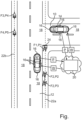
- the single figure shows a schematic representation of a traffic situation on an incoming road 10, which for example leads onto a main road 12, in order to illustrate a method for providing map data in a motor vehicle according to an embodiment of the invention.
- Two motor vehicles 14 are shown as an example, each of which also includes environmental sensors 16 in order to detect an environment or the surroundings 18 of the respective motor vehicles 14.
- This environmental sensor system 16 can now advantageously also be used to detect people in the surroundings 18 of the motor vehicles 14 and their positions.
- Such people can be pedestrians and/or cyclists or other non-motorized road users, for example.
- a first pedestrian F1 is shown at a first position P1, a second pedestrian F2 at a current second position P2 and this second pedestrian F2 at a temporally preceding third position P3, a cyclist F3 at an assigned fourth position P4 and another cyclist F4 at an assigned fifth position P5.
- the second pedestrian F2 not only can the current position of the persons F1 to F4 be recorded, in particular once, but these persons F1 to F4 can be recorded repeatedly, including their respective positions P1 to P5 at assigned times, as long as these persons F1 to F4 are in the detection ranges of the assigned environmental sensors 16 of the respective motor vehicles 14.
- respective position history data can also be provided for the respective persons F1 to F4.
- position data P of the respective recorded persons F1 to F4 recorded by the respective motor vehicles 14 are then transmitted to a central data processing device 20, such as a cloud server.
- This central data processing device 20 aggregates these position data P and evaluates them statistically. On the basis of the statistical evaluation of these aggregated position data P, paths 22a, 22b can thus be determined that were at least partially used by the recorded persons F1 to F4. If the position data P provided by numerous motor vehicles 14 are collected and aggregated over longer periods of time, the actual traffic routes used by pedestrians and/or people can be determined particularly precisely and reliably. These may also deviate from the structurally specified traffic routes.
- the route data W relating to the routes 22a, 22b determined in this way can then advantageously be made available to the motor vehicles 14, in particular also to other motor vehicles, in the form of a part of map data K.
- the real pedestrian and cycle routes can then also be taken into account in such a map K.
- movement data of the respective persons F1 to F4 can also be provided on the basis of the position data P. This also makes it possible to determine not only the routes 22a, 22b used by the persons F1 to F4, but also stopping points 24 on these respective routes 22a, 22b, if any, at which the persons F1 to F4 often or usually stop.
- Such stopping points 24 are typically located at the beginning of an intersection of the relevant route 22a, 22b used by the persons F1 to F4 and other traffic routes. In this example, the stopping point 24 is located at the beginning of the intersection of the pedestrian path 22a and the road 10 that leads into it. Particular caution is therefore required at such stopping points 24.
- These stopping points 24 can also be provided as part of the route data W to the relevant motor vehicles 14 as part of the map data K, and these can then can advantageously also be used by the respective motor vehicles 14 or by corresponding driver assistance systems.
- the example shows how the invention can generate a map for pedestrian and cycle paths including typical stopping points by aggregating swarm data, which also includes the real actual traffic routes of people that may be used differently from structural traffic routes.
- the measured routes can deviate from the map data derived from the structural framework conditions.
- This and the typical stopping points determined in addition can then be used by an emergency braking system, for example, to avoid incorrect interventions or to make interventions plausible.
- This also makes it possible to make traffic routes available even when there is a low density of use, i.e. when there are currently few visible pedestrians or cyclists. This can significantly increase road safety.
Landscapes
- Engineering & Computer Science (AREA)
- Remote Sensing (AREA)
- Radar, Positioning & Navigation (AREA)
- Physics & Mathematics (AREA)
- General Physics & Mathematics (AREA)
- Automation & Control Theory (AREA)
- Theoretical Computer Science (AREA)
- Multimedia (AREA)
- Business, Economics & Management (AREA)
- Life Sciences & Earth Sciences (AREA)
- Atmospheric Sciences (AREA)
- Tourism & Hospitality (AREA)
- Human Computer Interaction (AREA)
- Chemical & Material Sciences (AREA)
- Analytical Chemistry (AREA)
- Health & Medical Sciences (AREA)
- Economics (AREA)
- General Health & Medical Sciences (AREA)
- Human Resources & Organizations (AREA)
- Marketing (AREA)
- Primary Health Care (AREA)
- Strategic Management (AREA)
- Computer Vision & Pattern Recognition (AREA)
- General Business, Economics & Management (AREA)
- Traffic Control Systems (AREA)
- Operations Research (AREA)
Claims (9)
- Procédé permettant de fournir des données cartographiques (K) dans un premier véhicule automobile (14), comprenant les étapes consistant à :- transmettre à un dispositif de traitement de données central (20) des données de position (P) détectées par plusieurs deuxièmes véhicules automobiles (14) concernant des personnes (F1, F2, F3, F4) détectées par les deuxièmes véhicules automobiles (14) dans un environnement (18) des deuxièmes véhicules automobiles (14) respectifs ;- en fonction des données de position (P) agrégées, déterminer au moyen du dispositif de traitement de données central (20) au moins un chemin (22a, 22b) qui a été emprunté au moins partiellement par au moins certaines des personnes (F1, F2, F3, F4) ; et- fournir des données de cheminement (W) du au moins un chemin (22a, 22b) déterminé dans le cadre des données cartographiques (K) dans le premier véhicule automobile (14) ;caractérisé en ce qu'en fonction des données de position agrégées (P) il est vérifié si au moins un point d'arrêt (24) se trouve sur le chemin (22a, 22b) déterminé, et si c'est le cas, une position du point d'arrêt (24) est fournie au premier véhicule automobile (14) dans le cadre des données de cheminement (W), dans lequel en fonction des données de position (P) détectées, des données de mouvement des personnes (F1, F2, F3, F4) sont établies et ledit au moins un point d'arrêt (24) est déterminé en fonction des données de mouvement.
- Procédé selon la revendication 1, caractérisé en ce que les personnes (F1, F2, F3, F4) sont des piétons (F1, F2) et/ou des cyclistes (F3, F4).
- Procédé selon l'une quelconque des revendications précédentes, caractérisé en ce que les deuxièmes véhicules automobiles (14) détectent les personnes (F1, F2, F3, F4) dans l'environnement (18) respectif au moyen d'au moins un capteur d'environnement (16) respectivement.
- Procédé selon l'une quelconque des revendications précédentes, caractérisé en ce que les deuxièmes véhicules automobiles (14) détectent les données de position (P) des personnes (F1, F2, F3, F4) de manière répétée tant que les personnes (F1, F2, F3, F4) respectives se trouvent dans une zone de détection déterminée des deuxièmes véhicules automobiles (14) respectifs.
- Procédé selon l'une quelconque des revendications précédentes, caractérisé en ce que pour la détection d'au moins l'une des personnes (F1, F2, F3, F4) par au moins l'un des deuxièmes véhicules automobiles (14), un objet dans l'environnement (18) du deuxième véhicule automobile (14) est détecté, et l'objet détecté est classifié comme une personne (F1, F2, F3, F4) ou du moins comme étant lié à une personne (F1, F2, F3, F4).
- Procédé selon l'une quelconque des revendications précédentes, caractérisé en ce que pour la fourniture des données de position (P) concernant au moins l'une des personnes (F1, F2, F3, F4) détectées par au moins l'un des deuxièmes véhicules automobiles (14), une première position (P1, P2, P3, P4, P5) de la personne (F1, F2, F3, F4) détectée par rapport au deuxième véhicule automobile (14) est déterminée, et une deuxième position du deuxième véhicule automobile (14) est déterminée, et les données de position (P) sont établies en fonction de la première position (P1, P2, P3, P4, P5) et de la deuxième position.
- Procédé selon l'une quelconque des revendications précédentes, caractérisé en ce qu'au moins une fonction d'assistance au conducteur du premier véhicule automobile (14) est effectuée en fonction des données de cheminement (W) fournies.
- Véhicule automobile (14), qui est conçu pour détecter des personnes (F1, F2, F3, F4) dans l'environnement (18) du véhicule automobile (14) et pour déterminer des données de position (P) des personnes (F1, F2, F3, F4), dans lequel le véhicule automobile (14) est conçu pour transmettre les données de position (P) déterminées à un dispositif de traitement de données central (20), et pour recevoir du deuxième dispositif de traitement de données central (20) dans le cadre des données cartographiques (K) des données de cheminement (W) d'au moins un chemin (22a, 22b), déterminé sur la base de données de position (P) agrégées du véhicule automobile (14) et/ou de deuxièmes véhicules automobiles (14), qui a été emprunté au moins partiellement par des personnes (F1, F2, F3, F4),
caractérisé en ce qu'en fonction des données de position agrégées (P) il est vérifié si au moins un point d'arrêt (24) se trouve sur le chemin (22a, 22b) déterminé, et si c'est le cas, une position du point d'arrêt (24) est fournie au véhicule automobile (14) dans le cadre des données de cheminement (W), dans lequel en fonction des données de position (P) détectées, des données de mouvement des personnes (F1, F2, F3, F4) sont établies et ledit au moins un point d'arrêt (24) est déterminé en fonction des données de mouvement. - Dispositif de traitement de données central (20) permettant de fournir des données cartographiques (K) dans un premier véhicule automobile (14), dans lequel le dispositif de traitement de données central (20) est conçu pour- recevoir des données de position (P) détectées par plusieurs deuxièmes véhicules automobiles (14) concernant des personnes (F1, F2, F3, F4) détectées par les deuxièmes véhicules automobiles (14) dans un environnement (18) des deuxièmes véhicules automobiles (14) respectifs ;- agréger les données de position (P) reçues, et déterminer en fonction des données de position (P) agrégées au moins un chemin (22a, 22b) qui a été emprunté au moins partiellement par au moins certaines des personnes (F1, F2, F3, F4) ; et- fournir des données de cheminement (W) du au moins un chemin (22a, 22b) déterminé dans le cadre des données cartographiques (K) dans le premier véhicule automobile (14) ;caractérisé en ce que le dispositif de traitement de données central (20) est conçu pour vérifier en fonction des données de position (P) agrégées si au moins un point d'arrêt (24) se trouve sur le chemin (22a, 22b) déterminé, et si c'est le cas, fournir au premier véhicule automobile (14) une position du point d'arrêt (24) dans le cadre des données de cheminement (W), dans lequel le dispositif de traitement de données central (20) est conçu pour établir en fonction des données de position (P) détectées des données de mouvement des personnes (F1, F2, F3, F4) et pour déterminer ledit au moins un point d'arrêt (24) en fonction des données de mouvement.
Applications Claiming Priority (1)
| Application Number | Priority Date | Filing Date | Title |
|---|---|---|---|
| DE102018221054.3A DE102018221054B4 (de) | 2018-12-05 | 2018-12-05 | Verfahren zum Bereitstellen von Kartendaten in einem Kraftfahrzeug, Kraftfahrzeug und zentrale Datenverarbeitungseinrichtung |
Publications (2)
| Publication Number | Publication Date |
|---|---|
| EP3663719A1 EP3663719A1 (fr) | 2020-06-10 |
| EP3663719B1 true EP3663719B1 (fr) | 2024-09-25 |
Family
ID=68470360
Family Applications (1)
| Application Number | Title | Priority Date | Filing Date |
|---|---|---|---|
| EP19207417.7A Active EP3663719B1 (fr) | 2018-12-05 | 2019-11-06 | Procédé de fourniture de données de carte dans un véhicule automobile, véhicule automobile et dispositif central de traitement des données |
Country Status (4)
| Country | Link |
|---|---|
| US (1) | US11373534B2 (fr) |
| EP (1) | EP3663719B1 (fr) |
| CN (1) | CN111275997B (fr) |
| DE (1) | DE102018221054B4 (fr) |
Families Citing this family (10)
| Publication number | Priority date | Publication date | Assignee | Title |
|---|---|---|---|---|
| US11592813B2 (en) * | 2018-12-17 | 2023-02-28 | Robert Bosch Gmbh | Method and controller for the situational transmission of surroundings information of a vehicle |
| CN113661296A (zh) * | 2019-03-27 | 2021-11-16 | 住友建机株式会社 | 施工机械、支援系统 |
| US11537701B2 (en) * | 2020-04-01 | 2022-12-27 | Toyota Motor North America, Inc. | Transport related n-factor authentication |
| DE102020213115A1 (de) | 2020-10-19 | 2022-04-21 | Volkswagen Aktiengesellschaft | Verfahren zum Vermeiden eines Unfalls zwischen einem Kraftfahrzeug und einem weiteren Verkehrsteilnehmer, Sicherheitssystem für ein Kraftfahrzeug sowie Kraftfahrzeug |
| DE102021127078B4 (de) * | 2021-10-19 | 2025-03-20 | Cariad Se | Verfahren zum Plausibilisieren einer auf Basis von Schwarmdaten erzeugten Trajektorie für ein zumindest teilweise assistiert betriebenes Kraftfahrzeug, Computerprogrammprodukt sowie Assistenzsystem |
| CN114179804B (zh) * | 2021-11-24 | 2023-06-09 | 东风柳州汽车有限公司 | 车辆制动能量回收方法、装置、设备及存储介质 |
| DE102021132466B3 (de) | 2021-12-09 | 2023-06-15 | Joynext Gmbh | Erkennen eines Objekts in der Nähe eines Verkehrsteilnehmers |
| JP2024011505A (ja) * | 2022-07-14 | 2024-01-25 | 株式会社Subaru | 車外リスクの視認誘導装置 |
| DE102022207187A1 (de) | 2022-07-14 | 2024-01-25 | Robert Bosch Gesellschaft mit beschränkter Haftung | Verfahren und Vorrichtung zum Bereitstellen von Objektdatenwerten und zum Erstellen einer Karte |
| US12523492B2 (en) | 2024-01-19 | 2026-01-13 | Toyota Jidosha Kabushiki Kaisha | Systems and methods for generating drop-off point maps |
Family Cites Families (23)
| Publication number | Priority date | Publication date | Assignee | Title |
|---|---|---|---|---|
| US7202776B2 (en) | 1997-10-22 | 2007-04-10 | Intelligent Technologies International, Inc. | Method and system for detecting objects external to a vehicle |
| US6526352B1 (en) | 2001-07-19 | 2003-02-25 | Intelligent Technologies International, Inc. | Method and arrangement for mapping a road |
| ATE477547T1 (de) | 2005-04-18 | 2010-08-15 | Intel Corp | Dreidimensionale strassenlayoutschätzung aus videosequenzen durch verfolgung von fussgängern |
| DE102006040537A1 (de) | 2006-08-30 | 2008-03-13 | Deutsches Zentrum für Luft- und Raumfahrt e.V. | Fahrzeugassistenzsystem |
| JP2009083815A (ja) * | 2007-10-03 | 2009-04-23 | Fujitsu Ten Ltd | ドライブレコーダ装置および事故解析シミュレーション装置 |
| US8605947B2 (en) | 2008-04-24 | 2013-12-10 | GM Global Technology Operations LLC | Method for detecting a clear path of travel for a vehicle enhanced by object detection |
| US8509982B2 (en) | 2010-10-05 | 2013-08-13 | Google Inc. | Zone driving |
| EP2469233B1 (fr) * | 2010-12-27 | 2016-05-18 | Deutsche Post AG | Système de détection de routes |
| DE102013011969A1 (de) * | 2013-07-18 | 2015-01-22 | GM Global Technology Operations LLC (n. d. Gesetzen des Staates Delaware) | Verfahren zum Betreiben eines Kraftfahrzeugs und Kraftfahrzeug |
| EP4187523A1 (fr) | 2014-05-14 | 2023-05-31 | Mobileye Vision Technologies Ltd. | Systèmes et procédés de détection de bordure de trottoir et d'évaluation des risques pour les piétons |
| CN113158820B (zh) | 2014-08-18 | 2024-07-16 | 无比视视觉技术有限公司 | 在导航中对车道限制和施工区域的识别和预测 |
| US9248834B1 (en) | 2014-10-02 | 2016-02-02 | Google Inc. | Predicting trajectories of objects based on contextual information |
| WO2016070193A1 (fr) * | 2014-10-31 | 2016-05-06 | Nodal Inc. | Systèmes, appareil et procédés permettant d'améliorer la sécurité relative à des objets mobiles/en mouvement |
| US9786177B2 (en) | 2015-04-10 | 2017-10-10 | Honda Motor Co., Ltd. | Pedestrian path predictions |
| JP2017068335A (ja) * | 2015-09-28 | 2017-04-06 | ルネサスエレクトロニクス株式会社 | データ処理装置および車載通信装置 |
| US9734455B2 (en) | 2015-11-04 | 2017-08-15 | Zoox, Inc. | Automated extraction of semantic information to enhance incremental mapping modifications for robotic vehicles |
| EP3995782B1 (fr) | 2016-01-05 | 2026-03-18 | Mobileye Vision Technologies Ltd. | Systèmes et procédés d'estimation de futures trajectoires |
| DE102016203723A1 (de) | 2016-03-08 | 2017-09-14 | Robert Bosch Gmbh | Verfahren und System zum Bestimmen der Pose eines Fahrzeugs |
| US9607402B1 (en) | 2016-05-09 | 2017-03-28 | Iteris, Inc. | Calibration of pedestrian speed with detection zone for traffic intersection control |
| JP6617651B2 (ja) | 2016-07-07 | 2019-12-11 | 株式会社デンソー | 歩行者検出装置、歩行者検出方法 |
| JP6697349B2 (ja) * | 2016-08-10 | 2020-05-20 | パナソニック インテレクチュアル プロパティ コーポレーション オブ アメリカPanasonic Intellectual Property Corporation of America | 通信方法およびサーバ |
| US20180105107A1 (en) | 2016-10-19 | 2018-04-19 | Novateur Research Solutions LLC | Pedestrian collision warning system for vehicles |
| US10196058B2 (en) * | 2016-11-28 | 2019-02-05 | drive.ai Inc. | Method for influencing entities at a roadway intersection |
-
2018
- 2018-12-05 DE DE102018221054.3A patent/DE102018221054B4/de active Active
-
2019
- 2019-11-06 EP EP19207417.7A patent/EP3663719B1/fr active Active
- 2019-12-02 CN CN201911211639.3A patent/CN111275997B/zh active Active
- 2019-12-04 US US16/702,717 patent/US11373534B2/en active Active
Also Published As
| Publication number | Publication date |
|---|---|
| EP3663719A1 (fr) | 2020-06-10 |
| CN111275997A (zh) | 2020-06-12 |
| CN111275997B (zh) | 2022-09-02 |
| US20200184823A1 (en) | 2020-06-11 |
| DE102018221054B4 (de) | 2020-12-10 |
| US11373534B2 (en) | 2022-06-28 |
| DE102018221054A1 (de) | 2020-06-10 |
Similar Documents
| Publication | Publication Date | Title |
|---|---|---|
| EP3663719B1 (fr) | Procédé de fourniture de données de carte dans un véhicule automobile, véhicule automobile et dispositif central de traitement des données | |
| EP3350050B1 (fr) | Procédé de fourniture d'une information de voie relative à une voie de circulation et système | |
| EP2149131B1 (fr) | Procédé et dispositif d'identification d'informations importantes pour le trafic | |
| EP2601480B1 (fr) | Procédé et dispositif pour déterminer la position d'un véhicule sur une chaussée de circulation et automobiles équipées d'un tel dispositif | |
| DE112012006226B4 (de) | Fahrassistenzvorrichtung | |
| DE102010044631B4 (de) | Verfahren zur Bestimmung der Kollisionswahrscheinlichkeit eines Kraftfahrzeugs | |
| DE102009046913B4 (de) | Verfahren zur Müdigkeitserkennung, Vorrichtung und Computerprogrammprodukt | |
| DE102013212255A1 (de) | Verfahren zum Austausch von Informationen zwischen mindestens zwei Fahrzeugen | |
| WO2017097555A1 (fr) | Procédé pour assiter le conducteur d'un véhicule automobile concernant une manœuvre de dépassement imminente et véhicule automobile | |
| WO2017202522A1 (fr) | Procédé pour fournir une information de trajectoire de véhicule et procédé pour localiser un nid de poule | |
| DE102014009627A1 (de) | Verfahren zur Meldung einer freien Parklücke für ein Fahrzeug | |
| EP3609755B1 (fr) | Système d'assistance au conducteur pour un véhicule | |
| EP4176378A1 (fr) | Procédé de détection d'environnement au moyen d'au moins deux capteurs de détection d'environnement indépendants à formation d'image, dispositif pour la mise en ?uvre de ce procédé, véhicule et programme informatique conçu de manière correspondante | |
| WO2016150590A1 (fr) | Procédé et dispositif pour surveiller une trajectoire de consigne à parcourir par un véhicule au sujet de l'absence de collision | |
| DE102011084549A1 (de) | Verfahren zur Unterstützung eines Fahrers eines Fahrzeugs bei einem Ausparkvorgang aus einer Querparklücke | |
| WO2023036545A1 (fr) | Procédé et circuit de commande servant à vérifier si un mode de conduite actuellement actif est actionné dans sa limite odd, et système et serveur dorsal | |
| DE102018201111B4 (de) | Verfahren zur Überwachung zumindest eines Parkplatzes auf Verfügbarkeit sowie System zum Durchführen des Verfahrens | |
| DE102021209315A1 (de) | Verfahren zum Betreiben eines Infrastruktursystems zur Fahrunterstützung von zumindest teilautomatisiert geführten Kraftfahrzeugen | |
| DE102017201538A1 (de) | Verfahren zum Verarbeiten von Daten über ein in einer Umgebung eines ersten Fahrzeugs befindliches Objekt | |
| WO2023237424A1 (fr) | Procédé et système d'assistance pour prédire un trajet de conduite, et véhicule à moteur | |
| DE102016122200A1 (de) | Bilden einer Rettungsgasse unter Berücksichtigung deren Notwendigkeit | |
| DE102022210507A1 (de) | Alarmsystem zur Warnung vulnerabler Verkehrsteilnehmer in einem vorgegebenen Straßenabschnitt | |
| DE102019206870A1 (de) | Verfahren zum Ermitteln einer durch einen Verkehrsteilnehmer verursachten Gefährdung und zum Einleiten einer Überwachung des Verkehrsteilnehmers und Steuergerät | |
| EP3673234A1 (fr) | Procédé et dispositif permettant de déterminer une position très précise d'un véhicule automatisé et de le faire fonctionner | |
| DE102021005532A1 (de) | Verfahren zur Herstellung einer Kommunikationsverbindung und zur Kommunikation |
Legal Events
| Date | Code | Title | Description |
|---|---|---|---|
| PUAI | Public reference made under article 153(3) epc to a published international application that has entered the european phase |
Free format text: ORIGINAL CODE: 0009012 |
|
| STAA | Information on the status of an ep patent application or granted ep patent |
Free format text: STATUS: THE APPLICATION HAS BEEN PUBLISHED |
|
| AK | Designated contracting states |
Kind code of ref document: A1 Designated state(s): AL AT BE BG CH CY CZ DE DK EE ES FI FR GB GR HR HU IE IS IT LI LT LU LV MC MK MT NL NO PL PT RO RS SE SI SK SM TR |
|
| AX | Request for extension of the european patent |
Extension state: BA ME |
|
| STAA | Information on the status of an ep patent application or granted ep patent |
Free format text: STATUS: REQUEST FOR EXAMINATION WAS MADE |
|
| 17P | Request for examination filed |
Effective date: 20201210 |
|
| RBV | Designated contracting states (corrected) |
Designated state(s): AL AT BE BG CH CY CZ DE DK EE ES FI FR GB GR HR HU IE IS IT LI LT LU LV MC MK MT NL NO PL PT RO RS SE SI SK SM TR |
|
| REG | Reference to a national code |
Ref country code: DE Ref legal event code: R079 Free format text: PREVIOUS MAIN CLASS: G01C0021320000 Ipc: G01C0021000000 |
|
| RIC1 | Information provided on ipc code assigned before grant |
Ipc: G01C 21/36 20060101ALI20240425BHEP Ipc: G08G 1/01 20060101ALI20240425BHEP Ipc: G08G 1/13 20060101ALI20240425BHEP Ipc: G08G 1/16 20060101ALI20240425BHEP Ipc: G01C 21/32 20060101ALI20240425BHEP Ipc: G01C 21/00 20060101AFI20240425BHEP |
|
| GRAP | Despatch of communication of intention to grant a patent |
Free format text: ORIGINAL CODE: EPIDOSNIGR1 |
|
| STAA | Information on the status of an ep patent application or granted ep patent |
Free format text: STATUS: GRANT OF PATENT IS INTENDED |
|
| INTG | Intention to grant announced |
Effective date: 20240605 |
|
| P01 | Opt-out of the competence of the unified patent court (upc) registered |
Free format text: CASE NUMBER: APP_38097/2024 Effective date: 20240626 |
|
| GRAS | Grant fee paid |
Free format text: ORIGINAL CODE: EPIDOSNIGR3 |
|
| GRAA | (expected) grant |
Free format text: ORIGINAL CODE: 0009210 |
|
| STAA | Information on the status of an ep patent application or granted ep patent |
Free format text: STATUS: THE PATENT HAS BEEN GRANTED |
|
| AK | Designated contracting states |
Kind code of ref document: B1 Designated state(s): AL AT BE BG CH CY CZ DK EE ES FI FR GB GR HR HU IE IS IT LI LT LU LV MC MK MT NL NO PL PT RO RS SE SI SK SM TR |
|
| RBV | Designated contracting states (corrected) |
Designated state(s): AL AT BE BG CH CY CZ DK EE ES FI FR GB GR HR HU IE IS IT LI LT LU LV MC MK MT NL NO PL PT RO RS SE SI SK SM TR |
|
| REG | Reference to a national code |
Ref country code: GB Ref legal event code: FG4D Free format text: NOT ENGLISH |
|
| REG | Reference to a national code |
Ref country code: CH Ref legal event code: EP |
|
| REG | Reference to a national code |
Ref country code: IE Ref legal event code: FG4D Free format text: LANGUAGE OF EP DOCUMENT: GERMAN |
|
| REG | Reference to a national code |
Ref country code: LT Ref legal event code: MG9D |
|
| PG25 | Lapsed in a contracting state [announced via postgrant information from national office to epo] |
Ref country code: NO Free format text: LAPSE BECAUSE OF FAILURE TO SUBMIT A TRANSLATION OF THE DESCRIPTION OR TO PAY THE FEE WITHIN THE PRESCRIBED TIME-LIMIT Effective date: 20241225 |
|
| PG25 | Lapsed in a contracting state [announced via postgrant information from national office to epo] |
Ref country code: GR Free format text: LAPSE BECAUSE OF FAILURE TO SUBMIT A TRANSLATION OF THE DESCRIPTION OR TO PAY THE FEE WITHIN THE PRESCRIBED TIME-LIMIT Effective date: 20241226 Ref country code: FI Free format text: LAPSE BECAUSE OF FAILURE TO SUBMIT A TRANSLATION OF THE DESCRIPTION OR TO PAY THE FEE WITHIN THE PRESCRIBED TIME-LIMIT Effective date: 20240925 |
|
| PG25 | Lapsed in a contracting state [announced via postgrant information from national office to epo] |
Ref country code: BG Free format text: LAPSE BECAUSE OF FAILURE TO SUBMIT A TRANSLATION OF THE DESCRIPTION OR TO PAY THE FEE WITHIN THE PRESCRIBED TIME-LIMIT Effective date: 20240925 |
|
| PG25 | Lapsed in a contracting state [announced via postgrant information from national office to epo] |
Ref country code: LV Free format text: LAPSE BECAUSE OF FAILURE TO SUBMIT A TRANSLATION OF THE DESCRIPTION OR TO PAY THE FEE WITHIN THE PRESCRIBED TIME-LIMIT Effective date: 20240925 |
|
| PG25 | Lapsed in a contracting state [announced via postgrant information from national office to epo] |
Ref country code: RS Free format text: LAPSE BECAUSE OF FAILURE TO SUBMIT A TRANSLATION OF THE DESCRIPTION OR TO PAY THE FEE WITHIN THE PRESCRIBED TIME-LIMIT Effective date: 20241225 |
|
| REG | Reference to a national code |
Ref country code: NL Ref legal event code: MP Effective date: 20240925 |
|
| PG25 | Lapsed in a contracting state [announced via postgrant information from national office to epo] |
Ref country code: RS Free format text: LAPSE BECAUSE OF FAILURE TO SUBMIT A TRANSLATION OF THE DESCRIPTION OR TO PAY THE FEE WITHIN THE PRESCRIBED TIME-LIMIT Effective date: 20241225 Ref country code: NO Free format text: LAPSE BECAUSE OF FAILURE TO SUBMIT A TRANSLATION OF THE DESCRIPTION OR TO PAY THE FEE WITHIN THE PRESCRIBED TIME-LIMIT Effective date: 20241225 Ref country code: LV Free format text: LAPSE BECAUSE OF FAILURE TO SUBMIT A TRANSLATION OF THE DESCRIPTION OR TO PAY THE FEE WITHIN THE PRESCRIBED TIME-LIMIT Effective date: 20240925 Ref country code: GR Free format text: LAPSE BECAUSE OF FAILURE TO SUBMIT A TRANSLATION OF THE DESCRIPTION OR TO PAY THE FEE WITHIN THE PRESCRIBED TIME-LIMIT Effective date: 20241226 Ref country code: FI Free format text: LAPSE BECAUSE OF FAILURE TO SUBMIT A TRANSLATION OF THE DESCRIPTION OR TO PAY THE FEE WITHIN THE PRESCRIBED TIME-LIMIT Effective date: 20240925 Ref country code: BG Free format text: LAPSE BECAUSE OF FAILURE TO SUBMIT A TRANSLATION OF THE DESCRIPTION OR TO PAY THE FEE WITHIN THE PRESCRIBED TIME-LIMIT Effective date: 20240925 |
|
| PG25 | Lapsed in a contracting state [announced via postgrant information from national office to epo] |
Ref country code: NL Free format text: LAPSE BECAUSE OF FAILURE TO SUBMIT A TRANSLATION OF THE DESCRIPTION OR TO PAY THE FEE WITHIN THE PRESCRIBED TIME-LIMIT Effective date: 20240925 |
|
| PG25 | Lapsed in a contracting state [announced via postgrant information from national office to epo] |
Ref country code: PT Free format text: LAPSE BECAUSE OF FAILURE TO SUBMIT A TRANSLATION OF THE DESCRIPTION OR TO PAY THE FEE WITHIN THE PRESCRIBED TIME-LIMIT Effective date: 20250127 Ref country code: IS Free format text: LAPSE BECAUSE OF FAILURE TO SUBMIT A TRANSLATION OF THE DESCRIPTION OR TO PAY THE FEE WITHIN THE PRESCRIBED TIME-LIMIT Effective date: 20250125 |
|
| PG25 | Lapsed in a contracting state [announced via postgrant information from national office to epo] |
Ref country code: RO Free format text: LAPSE BECAUSE OF FAILURE TO SUBMIT A TRANSLATION OF THE DESCRIPTION OR TO PAY THE FEE WITHIN THE PRESCRIBED TIME-LIMIT Effective date: 20240925 Ref country code: SM Free format text: LAPSE BECAUSE OF FAILURE TO SUBMIT A TRANSLATION OF THE DESCRIPTION OR TO PAY THE FEE WITHIN THE PRESCRIBED TIME-LIMIT Effective date: 20240925 |
|
| PG25 | Lapsed in a contracting state [announced via postgrant information from national office to epo] |
Ref country code: ES Free format text: LAPSE BECAUSE OF FAILURE TO SUBMIT A TRANSLATION OF THE DESCRIPTION OR TO PAY THE FEE WITHIN THE PRESCRIBED TIME-LIMIT Effective date: 20240925 |
|
| PG25 | Lapsed in a contracting state [announced via postgrant information from national office to epo] |
Ref country code: EE Free format text: LAPSE BECAUSE OF FAILURE TO SUBMIT A TRANSLATION OF THE DESCRIPTION OR TO PAY THE FEE WITHIN THE PRESCRIBED TIME-LIMIT Effective date: 20240925 |
|
| PG25 | Lapsed in a contracting state [announced via postgrant information from national office to epo] |
Ref country code: PL Free format text: LAPSE BECAUSE OF FAILURE TO SUBMIT A TRANSLATION OF THE DESCRIPTION OR TO PAY THE FEE WITHIN THE PRESCRIBED TIME-LIMIT Effective date: 20240925 Ref country code: CZ Free format text: LAPSE BECAUSE OF FAILURE TO SUBMIT A TRANSLATION OF THE DESCRIPTION OR TO PAY THE FEE WITHIN THE PRESCRIBED TIME-LIMIT Effective date: 20240925 |
|
| PG25 | Lapsed in a contracting state [announced via postgrant information from national office to epo] |
Ref country code: IT Free format text: LAPSE BECAUSE OF FAILURE TO SUBMIT A TRANSLATION OF THE DESCRIPTION OR TO PAY THE FEE WITHIN THE PRESCRIBED TIME-LIMIT Effective date: 20240925 Ref country code: SK Free format text: LAPSE BECAUSE OF FAILURE TO SUBMIT A TRANSLATION OF THE DESCRIPTION OR TO PAY THE FEE WITHIN THE PRESCRIBED TIME-LIMIT Effective date: 20240925 |
|
| REG | Reference to a national code |
Ref country code: CH Ref legal event code: PL |
|
| PG25 | Lapsed in a contracting state [announced via postgrant information from national office to epo] |
Ref country code: MC Free format text: LAPSE BECAUSE OF FAILURE TO SUBMIT A TRANSLATION OF THE DESCRIPTION OR TO PAY THE FEE WITHIN THE PRESCRIBED TIME-LIMIT Effective date: 20240925 |
|
| PG25 | Lapsed in a contracting state [announced via postgrant information from national office to epo] |
Ref country code: DK Free format text: LAPSE BECAUSE OF FAILURE TO SUBMIT A TRANSLATION OF THE DESCRIPTION OR TO PAY THE FEE WITHIN THE PRESCRIBED TIME-LIMIT Effective date: 20240925 |
|
| PG25 | Lapsed in a contracting state [announced via postgrant information from national office to epo] |
Ref country code: LU Free format text: LAPSE BECAUSE OF NON-PAYMENT OF DUE FEES Effective date: 20241106 |
|
| REG | Reference to a national code |
Ref country code: CH Ref legal event code: PL |
|
| PG25 | Lapsed in a contracting state [announced via postgrant information from national office to epo] |
Ref country code: CH Free format text: LAPSE BECAUSE OF NON-PAYMENT OF DUE FEES Effective date: 20241130 |
|
| PLBE | No opposition filed within time limit |
Free format text: ORIGINAL CODE: 0009261 |
|
| STAA | Information on the status of an ep patent application or granted ep patent |
Free format text: STATUS: NO OPPOSITION FILED WITHIN TIME LIMIT |
|
| REG | Reference to a national code |
Ref country code: BE Ref legal event code: MM Effective date: 20241130 |
|
| 26N | No opposition filed |
Effective date: 20250626 |
|
| PG25 | Lapsed in a contracting state [announced via postgrant information from national office to epo] |
Ref country code: SE Free format text: LAPSE BECAUSE OF FAILURE TO SUBMIT A TRANSLATION OF THE DESCRIPTION OR TO PAY THE FEE WITHIN THE PRESCRIBED TIME-LIMIT Effective date: 20240925 |
|
| PG25 | Lapsed in a contracting state [announced via postgrant information from national office to epo] |
Ref country code: BE Free format text: LAPSE BECAUSE OF NON-PAYMENT OF DUE FEES Effective date: 20241130 |
|
| PG25 | Lapsed in a contracting state [announced via postgrant information from national office to epo] |
Ref country code: IE Free format text: LAPSE BECAUSE OF NON-PAYMENT OF DUE FEES Effective date: 20241106 |
|
| PGFP | Annual fee paid to national office [announced via postgrant information from national office to epo] |
Ref country code: GB Payment date: 20251125 Year of fee payment: 7 |
|
| PG25 | Lapsed in a contracting state [announced via postgrant information from national office to epo] |
Ref country code: AT Free format text: LAPSE BECAUSE OF NON-PAYMENT OF DUE FEES Effective date: 20241106 |
|
| PG25 | Lapsed in a contracting state [announced via postgrant information from national office to epo] |
Ref country code: HR Free format text: LAPSE BECAUSE OF FAILURE TO SUBMIT A TRANSLATION OF THE DESCRIPTION OR TO PAY THE FEE WITHIN THE PRESCRIBED TIME-LIMIT Effective date: 20240925 |
|
| PGFP | Annual fee paid to national office [announced via postgrant information from national office to epo] |
Ref country code: FR Payment date: 20251124 Year of fee payment: 7 |
|
| REG | Reference to a national code |
Ref country code: AT Ref legal event code: MM01 Ref document number: 1726956 Country of ref document: AT Kind code of ref document: T Effective date: 20241106 |
|
| PG25 | Lapsed in a contracting state [announced via postgrant information from national office to epo] |
Ref country code: HU Free format text: LAPSE BECAUSE OF FAILURE TO SUBMIT A TRANSLATION OF THE DESCRIPTION OR TO PAY THE FEE WITHIN THE PRESCRIBED TIME-LIMIT; INVALID AB INITIO Effective date: 20191106 |
|
| PG25 | Lapsed in a contracting state [announced via postgrant information from national office to epo] |
Ref country code: CY Free format text: LAPSE BECAUSE OF FAILURE TO SUBMIT A TRANSLATION OF THE DESCRIPTION OR TO PAY THE FEE WITHIN THE PRESCRIBED TIME-LIMIT; INVALID AB INITIO Effective date: 20191106 |