WO2020008754A1 - Dispositif de traitement d'informations, procédé d'estimation d'instant optimal, procédé d'estimation de position propre et support d'enregistrement dans lequel un programme est enregistré - Google Patents
Dispositif de traitement d'informations, procédé d'estimation d'instant optimal, procédé d'estimation de position propre et support d'enregistrement dans lequel un programme est enregistré Download PDFInfo
- Publication number
- WO2020008754A1 WO2020008754A1 PCT/JP2019/020971 JP2019020971W WO2020008754A1 WO 2020008754 A1 WO2020008754 A1 WO 2020008754A1 JP 2019020971 W JP2019020971 W JP 2019020971W WO 2020008754 A1 WO2020008754 A1 WO 2020008754A1
- Authority
- WO
- WIPO (PCT)
- Prior art keywords
- information
- map
- sensor
- time
- self
- Prior art date
- Legal status (The legal status is an assumption and is not a legal conclusion. Google has not performed a legal analysis and makes no representation as to the accuracy of the status listed.)
- Ceased
Links
Images




Classifications
-
- G—PHYSICS
- G05—CONTROLLING; REGULATING
- G05D—SYSTEMS FOR CONTROLLING OR REGULATING NON-ELECTRIC VARIABLES
- G05D1/00—Control of position, course, altitude or attitude of land, water, air or space vehicles, e.g. using automatic pilots
- G05D1/02—Control of position or course in two dimensions
- G05D1/021—Control of position or course in two dimensions specially adapted to land vehicles
- G05D1/0268—Control of position or course in two dimensions specially adapted to land vehicles using internal positioning means
- G05D1/0274—Control of position or course in two dimensions specially adapted to land vehicles using internal positioning means using mapping information stored in a memory device
-
- G—PHYSICS
- G01—MEASURING; TESTING
- G01C—MEASURING DISTANCES, LEVELS OR BEARINGS; SURVEYING; NAVIGATION; GYROSCOPIC INSTRUMENTS; PHOTOGRAMMETRY OR VIDEOGRAMMETRY
- G01C21/00—Navigation; Navigational instruments not provided for in groups G01C1/00 - G01C19/00
- G01C21/38—Electronic maps specially adapted for navigation; Updating thereof
- G01C21/3804—Creation or updating of map data
- G01C21/3833—Creation or updating of map data characterised by the source of data
-
- G—PHYSICS
- G05—CONTROLLING; REGULATING
- G05D—SYSTEMS FOR CONTROLLING OR REGULATING NON-ELECTRIC VARIABLES
- G05D1/00—Control of position, course, altitude or attitude of land, water, air or space vehicles, e.g. using automatic pilots
- G05D1/02—Control of position or course in two dimensions
- G05D1/021—Control of position or course in two dimensions specially adapted to land vehicles
- G05D1/0231—Control of position or course in two dimensions specially adapted to land vehicles using optical position detecting means
-
- G—PHYSICS
- G05—CONTROLLING; REGULATING
- G05D—SYSTEMS FOR CONTROLLING OR REGULATING NON-ELECTRIC VARIABLES
- G05D1/00—Control of position, course, altitude or attitude of land, water, air or space vehicles, e.g. using automatic pilots
- G05D1/02—Control of position or course in two dimensions
- G05D1/021—Control of position or course in two dimensions specially adapted to land vehicles
- G05D1/0268—Control of position or course in two dimensions specially adapted to land vehicles using internal positioning means
- G05D1/027—Control of position or course in two dimensions specially adapted to land vehicles using internal positioning means comprising intertial navigation means, e.g. azimuth detector
-
- G—PHYSICS
- G05—CONTROLLING; REGULATING
- G05D—SYSTEMS FOR CONTROLLING OR REGULATING NON-ELECTRIC VARIABLES
- G05D1/00—Control of position, course, altitude or attitude of land, water, air or space vehicles, e.g. using automatic pilots
- G05D1/02—Control of position or course in two dimensions
- G05D1/021—Control of position or course in two dimensions specially adapted to land vehicles
- G05D1/0276—Control of position or course in two dimensions specially adapted to land vehicles using signals provided by a source external to the vehicle
- G05D1/0278—Control of position or course in two dimensions specially adapted to land vehicles using signals provided by a source external to the vehicle using satellite positioning signals, e.g. GPS
-
- G—PHYSICS
- G06—COMPUTING OR CALCULATING; COUNTING
- G06F—ELECTRIC DIGITAL DATA PROCESSING
- G06F18/00—Pattern recognition
- G06F18/20—Analysing
- G06F18/24—Classification techniques
-
- G—PHYSICS
- G06—COMPUTING OR CALCULATING; COUNTING
- G06T—IMAGE DATA PROCESSING OR GENERATION, IN GENERAL
- G06T7/00—Image analysis
- G06T7/70—Determining position or orientation of objects or cameras
- G06T7/73—Determining position or orientation of objects or cameras using feature-based methods
-
- G—PHYSICS
- G06—COMPUTING OR CALCULATING; COUNTING
- G06V—IMAGE OR VIDEO RECOGNITION OR UNDERSTANDING
- G06V10/00—Arrangements for image or video recognition or understanding
- G06V10/70—Arrangements for image or video recognition or understanding using pattern recognition or machine learning
- G06V10/74—Image or video pattern matching; Proximity measures in feature spaces
- G06V10/75—Organisation of the matching processes, e.g. simultaneous or sequential comparisons of image or video features; Coarse-fine approaches, e.g. multi-scale approaches; using context analysis; Selection of dictionaries
- G06V10/757—Matching configurations of points or features
-
- G—PHYSICS
- G06—COMPUTING OR CALCULATING; COUNTING
- G06V—IMAGE OR VIDEO RECOGNITION OR UNDERSTANDING
- G06V20/00—Scenes; Scene-specific elements
- G06V20/50—Context or environment of the image
- G06V20/56—Context or environment of the image exterior to a vehicle by using sensors mounted on the vehicle
-
- G—PHYSICS
- G06—COMPUTING OR CALCULATING; COUNTING
- G06T—IMAGE DATA PROCESSING OR GENERATION, IN GENERAL
- G06T2207/00—Indexing scheme for image analysis or image enhancement
- G06T2207/10—Image acquisition modality
- G06T2207/10016—Video; Image sequence
-
- G—PHYSICS
- G06—COMPUTING OR CALCULATING; COUNTING
- G06T—IMAGE DATA PROCESSING OR GENERATION, IN GENERAL
- G06T2207/00—Indexing scheme for image analysis or image enhancement
- G06T2207/10—Image acquisition modality
- G06T2207/10028—Range image; Depth image; 3D point clouds
-
- G—PHYSICS
- G06—COMPUTING OR CALCULATING; COUNTING
- G06T—IMAGE DATA PROCESSING OR GENERATION, IN GENERAL
- G06T2207/00—Indexing scheme for image analysis or image enhancement
- G06T2207/30—Subject of image; Context of image processing
- G06T2207/30248—Vehicle exterior or interior
- G06T2207/30252—Vehicle exterior; Vicinity of vehicle
Definitions
- the present disclosure relates to an information processing apparatus, an optimal time estimation method, a self-position estimation method, and a recording medium on which a program is recorded.
- self-position In an autonomous mobile body, the current position and attitude of the own aircraft (hereinafter referred to as “self-position”) are accurately estimated not only to reliably reach a destination but also to safely act according to the surrounding environment. It becomes important.
- SLAM Simultaneous Localization and Mapping
- SLAM is a technology for simultaneously estimating a self-position and creating an environmental map.
- a self- Estimate the position For example, in estimating a self-position using an environmental map, a wide-area map created in advance (hereinafter referred to as an advance map) is compared with a local environmental map created from information acquired in real time by a sensor.
- the self-position is estimated by (map matching) specifying the location where both match.
- the advance map is, for example, information in which the shape of an environment such as an obstacle existing in a certain area is recorded as a two-dimensional map or a three-dimensional map
- the environmental map is, for example, around an autonomous mobile object. This is information expressing the shape of an environment such as an existing obstacle as a two-dimensional map or a three-dimensional map.
- the pre-map used for the self-position estimation using the environmental map is created, for example, by acquiring necessary information when the autonomous mobile body itself moves in the target area.
- a preliminary map is created in a situation where there are many moving objects such as a person and a car, the precision of the preliminary map is reduced, and accordingly, the accuracy of the self-position estimation is reduced.
- the present disclosure proposes an information processing apparatus capable of improving the accuracy of self-position estimation, an optimal time estimation method, a self-position estimation method, and a recording medium on which a program is recorded.
- an information processing apparatus provides time information regarding a time when a moving object is present in the predetermined area based on external world information of a predetermined area detected by an external sensor.
- a determining unit that determines an acquisition time for acquiring information for creating a pre-map used when the mobile body estimates its own position based on the information.
- an information processing apparatus it is possible to estimate an optimal time for acquiring information used in creating a preliminary map based on time information regarding a time at which a moving object was present. This makes it possible to create a pre-map that enables more accurate self-position estimation. As a result, it is possible to realize an information processing apparatus, an optimal time estimating method, a self-position estimating method, and a recording medium on which a program is recorded, which can improve the accuracy of the self-position estimation.
- FIG. 1 is a block diagram illustrating a schematic configuration example of an autonomous mobile body according to an embodiment of the present disclosure.
- 1 is a block diagram illustrating a schematic configuration example of a self-position estimation device (system) according to an embodiment of the present disclosure.
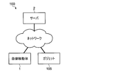
- FIG. 1 is a diagram illustrating an example of a self-position estimation system according to an embodiment of the present disclosure.
- 1 is a block diagram illustrating a more detailed configuration example of a self-position estimation device (system) according to an embodiment of the present disclosure. It is a figure showing an example of the prior art object information table concerning one embodiment of this indication.
- 5 is a flowchart illustrating a schematic flow of a self-position estimation operation according to an embodiment of the present disclosure.
- FIG. 15 is a block diagram illustrating a detailed configuration example of a self-position estimating device (system) according to a modified example of an embodiment of the present disclosure.
- the self-position estimation is performed by estimating the optimal time or time zone (hereinafter, referred to as an optimal time) for creating a preliminary map, and acquiring information for creating a preliminary map at the estimated optimal time. Create a pre-map to improve the accuracy of the map.
- FIG. 1 is a block diagram showing a schematic configuration example of the autonomous mobile according to the present embodiment.
- the autonomous mobile body 1 includes, for example, a CPU (Central Processing Unit) 12, a DRAM (Dynamic Random Access Memory) 13, a flash ROM (Read Only Memory) 14, and a PC (Personal Computer) card interface (I).
- / F) 15, a control unit 10 formed by connecting the wireless communication unit 16 and the signal processing circuit 11 to each other via an internal bus 17, and a battery 18 as a power source of the autonomous mobile unit 1.
- the autonomous mobile body 1 has a movable part 26 such as a joint part of an arm and a leg, a wheel or a caterpillar, and an operating mechanism for realizing an operation such as movement and gesture, and a drive part for driving the movable part. And an actuator 27.
- the autonomous mobile body 1 serves as a sensor for acquiring information such as a moving distance, a moving speed, a moving direction, and a posture (hereinafter, referred to as an inner field sensor) for detecting the direction and the acceleration of the own machine.
- An inertial measurement device (Inertial Measurement Unit) (IMU) 20 and an encoder (or potentiometer) 28 for detecting a driving amount of an actuator 27 are provided.
- an acceleration sensor, an angular velocity sensor, or the like can be used as the inner field sensor.
- the autonomous mobile body 1 captures an external situation as a sensor (hereinafter, referred to as an external sensor) that acquires information such as the terrain around the own device and the distance and direction to an object existing around the own device.
- an external sensor that acquires information such as the terrain around the own device and the distance and direction to an object existing around the own device.
- ToF Time of Flight
- LIDAR Light Detection and Ranging or Laser Imaging and Detection and Ranging
- GPS Global Positioning System
- magnetic sensor magnetic sensor
- Bluetooth registered trademark
- Wi-Fi Wi-Fi
- a measurement unit hereinafter, referred to as a radio field intensity sensor of the radio field intensity in the wireless communication unit 16 such as a trademark may be used.
- the autonomous mobile body 1 includes a touch sensor 22 for detecting a physical pressure received from the outside, a microphone 23 for collecting external sounds, and a speaker 24 for outputting sounds and the like to the surroundings. Also, a display unit 25 for displaying various information to a user or the like may be provided.
- various sensors such as the IMU 20, the touch sensor 22, the ToF sensor 21, the microphone 23, the speaker 24, and the encoder (or potentiometer) 28, the display unit, the actuator 27, the CCD camera (hereinafter simply referred to as a camera) 19, and the battery Reference numerals 18 are connected to the signal processing circuit 11 of the control unit 10, respectively.
- the signal processing circuit 14 sequentially captures sensor data, image data, and audio data supplied from the various sensors described above, and sequentially stores them at predetermined positions in the DRAM 13 via the internal bus 17.
- the signal processing circuit 11 sequentially takes in remaining battery power data indicating the remaining battery power supplied from the battery 18 and stores the data in a predetermined position in the DRAM 13.
- the sensor data, image data, audio data, and battery remaining amount data stored in the DRAM 13 in this manner are used when the CPU 12 controls the operation of the autonomous mobile unit 1 and, if necessary, perform wireless communication.
- the data is transmitted to an external server or the like via the unit 16.
- the wireless communication unit 16 communicates with an external server or the like via a predetermined network such as a wireless LAN (Local Area Network) or a mobile communication network in addition to Bluetooth (registered trademark) and Wi-Fi (registered trademark). It may be a communication unit for performing communication.
- the CPU 12 transmits the control program stored in the memory card 30 or the flash ROM 14 loaded in the PC card slot (not shown) via the PC card interface 15 or directly. Read and store this in the DRAM 13.
- the CPU 12 based on the sensor data, image data, audio data, and remaining battery power data sequentially stored in the DRAM 13 from the signal processing circuit 11 as described above, the status of its own device and the surroundings, and instructions from the user. Judge whether there is any action or not.
- the CPU 12 performs self-position estimation and various operations using map data stored in the DRAM 13 or the like or map data acquired from an external server or the like via the wireless communication unit 16 and various information. .
- the CPU 12 determines the subsequent action based on the above-described determination result, the estimated self-position, the control program stored in the DRAM 13, and drives the necessary actuator 27 based on the determination result.
- various actions such as movement and gesture are executed.
- the CPU 12 generates audio data as necessary, and supplies the generated audio data to the speaker 24 as an audio signal via the signal processing circuit 11 so that the audio based on the audio signal is output to the outside, or the display unit 25 To display various information.
- the autonomous mobile body 1 is configured to be able to act autonomously according to its own device and surrounding conditions, and instructions and actions from the user.
- the configuration of the autonomous mobile 1 described above is merely an example, and various autonomous mobiles can be applied according to purposes and applications. That is, the autonomous mobile object 1 according to the present disclosure is not limited to an autonomous mobile robot such as a domestic pet robot, a robot cleaner, an unmanned aerial vehicle, a following transport robot, and the like, but may include various mobile objects such as a car that estimates its own position. It is possible to apply.
- an autonomous mobile robot such as a domestic pet robot, a robot cleaner, an unmanned aerial vehicle, a following transport robot, and the like
- various mobile objects such as a car that estimates its own position. It is possible to apply.
- SLAM exists as a technique for estimating its own position.
- map matching exists as one of the techniques for realizing SLAM.
- Map matching is, for example, a technique for identifying matching feature points and mismatching feature points between different map data. Moving object detection, map combination, and self-position estimation (also referred to as map search) when performing SLAM are performed. And so on.
- map matching For example, in the moving object detection, two or more map data created using information acquired by the sensor at different times are compared (map matching) to specify a matching feature point and a mismatching feature point.
- a stationary object wall, sign, etc.
- a moving object person, chair, etc.
- map matching is used when a large-scale map data (for example, an advance map) is created by aligning and combining a collection of small-scale map data (for example, an environmental map).
- a large-scale map data for example, an advance map
- small-scale map data for example, an environmental map
- map search a pre-created map is compared with an environment map created in real time (map matching) to identify a location where both match. , Its own position is estimated.
- the high information density means that the number of stationary objects (or the number of feature points) per unit area is large, for example.
- the preliminary map used for the self-position estimation is, for example, an occupied grid map created using information (hereinafter, referred to as outside world information) acquired by an outside world sensor that detects the surrounding environment such as a camera, a ToF sensor, and a LIDAR sensor. And image feature point information. Therefore, if the external information used to create the preliminary map includes moving objects such as people, pets, and chairs, creating a preliminary map using the external information as it is will result in moving objects that have already moved. Since a prior map included as if it were a stationary object is created, the accuracy of self-position estimation by map matching is reduced.
- information on the own device acquired by the inside sensor is referred to as inside information, in contrast to the outside information acquired by the outside sensor.
- a method of removing the moving object information from the external world information acquired for the preparation of the preliminary map can be considered.
- the external information is a still image acquired by a camera
- a region occupied by the moving object in the still image is removed by a mask process or the like.
- the information density of the pre-map is reduced, which may make it difficult to perform highly accurate self-position estimation.
- an information processing apparatus an information processing system, an optimal time estimation method, a self-position estimation method, and a program that enable a highly accurate self-position estimation while suppressing a decrease in the information density of the preliminary map are described. A description will be given.
- FIG. 2 is a block diagram illustrating a schematic configuration example of a self-location estimation device (system) according to the present embodiment.
- the self-position estimating apparatus (system) 100 includes a pre-mapping optimum time estimating unit 101, a self-position estimating pre-map creating unit 102, a pre-map database (map storage unit) 103, A position estimating unit (determining unit) 104.
- Advance map creation optimal time estimating section 101 estimates and determines an optimal time to acquire information used in creating an advance map for a specific area in which autonomous mobile body 1 operates. Specifically, the pre-mapping optimal time estimating unit 101 determines a time zone in which the ratio of the information of the moving object in the external world information acquired by using the external sensor mounted on the autonomous mobile body 1 will be the smallest. It is estimated as an optimal time for acquiring information used in creating a preliminary map, and this time is determined as a time for acquiring information used in creating a preliminary map. For example, the advance map creation optimum time estimation unit 101 determines a time zone in which the proportion of the region occupied by the moving object in the image acquired by the camera (for example, the camera 19 in FIG.
- the advance map creation optimal time estimation unit 101 uses a time zone in which the number of moving objects included in the image acquired by the camera (for example, the camera 19 in FIG. 1) will be the smallest in the creation of the advance map. It is estimated and determined as the optimal time for acquiring the information to be performed.
- the self-position estimating prior map creation unit 102 acquires information on the region where the autonomous mobile 1 operates at the optimal time estimated by the advance map creation optimal time estimating unit 101, and uses the acquired information to advance Create a map.
- the self-position estimation pre-map creation unit 102 stores the data of the prepared pre-map in the pre-map database 103.
- the self-position estimating unit 104 performs the self-position estimation of the autonomous mobile 1 using the pre-map obtained from the pre-map database 103. For example, the self-position estimating unit 104 obtains a pre-map of the area to which the autonomous mobile 1 currently belongs and the surrounding map of the autonomous mobile 1 from the pre-map database 103, and obtains the obtained pre-map and information obtained in real time by the sensor. Is used to estimate the self-position of the autonomous mobile 1. For example, the self-position estimating unit 104 compares the acquired prior map with a local environmental map created from information acquired in real time from the sensor, and identifies a location where both match (map matching). The self-position of the autonomous mobile body 1 is estimated.
- the self-position estimation device (system) 100 shown in FIG. 2 may be realized by the autonomous mobile 1 alone, or the autonomous mobile 1 and the server 2 may be connected to the Internet, a LAN, or the like as shown in FIG. It may be realized by a system (including the case of cloud computing) connected via a predetermined network 3 such as a mobile communication network.
- FIG. 4 is a block diagram showing a more detailed configuration example of the self-position estimating apparatus (system) according to the present embodiment.
- FIG. 2 is a block diagram focusing on the configuration of FIG.
- the pre-map creation optimal time estimating unit 101 and the pre-map self-position estimating unit 102 in the self-position estimating apparatus (system) 100 include a sensor group 111 including an external sensor 112 and an internal sensor 113.
- the sensor group 111, the moving object detecting unit 114, the self-position estimating unit 115, and the pre-map creating unit 118 constitute the pre-map creating unit 102 for self-position estimating.
- the external sensor 112 in the sensor group 111 is a sensor for acquiring information on the environment around the autonomous mobile 1.
- a LIDAR sensor in addition to the camera 19 and the ToF sensor 21, a LIDAR sensor, a GPS sensor, a magnetic sensor, a radio wave intensity sensor, or the like can be used.
- image data which may be a still image or a moving image.
- ToF sensor 21 information on the distance to an object existing around the autonomous mobile 1 and its direction are acquired.
- the inner field sensor 113 is a sensor for acquiring information on the direction, movement, posture, and the like of the autonomous mobile body 1.
- an acceleration sensor, a gyro sensor, or the like can be used in addition to the encoder (or a potentiometer) 28 of each wheel and each joint, the IMU 20, and the like.
- the self-position estimating unit 115 estimates the current position and the posture (self-position) of the autonomous mobile 1 using the external information input from the external sensor 112 and / or the internal information input from the internal sensor 113. .
- a dead reckoning method and a star reckoning method are exemplified as a method of estimating the self-position of the autonomous mobile body 1 (hereinafter, simply referred to as a self-position estimating method).
- self-position estimating section 115 may have the same configuration as self-position estimating section 104, or may have a separate and independent configuration.
- the self-position estimation method of the dead reckoning method refers to a self-position estimation method of the autonomous mobile body 1 using inner field information input from an inner field sensor 113 such as an encoder 28, an IMU 20, an acceleration sensor, a gyro sensor, and a kinematic calculation. This is a method of estimating.
- the dead reckoning self-position estimation method also includes an odometry calculation method based on forward dynamics calculation based on the value of the encoder 28 attached to each joint of the autonomous mobile 1 and information on the geometric shape of the autonomous mobile 1. Have been. Physical quantities that can be acquired as inner world information include speed, acceleration, relative position, angular velocity, and the like.
- the absolute position and orientation required for the self-position estimation are calculated by integrating these physical quantities.
- the self-position estimation by the dead reckoning method has an advantage in that information on the self-position can be continuously calculated without interruption at a constant rate of a higher rate than the external sensor 112.
- since integration processing is performed to estimate an absolute position or posture there is a demerit that a cumulative error occurs in a long-time measurement.
- the self-position estimation method of the star reckoning method refers to autonomous movement by map matching or geometric shape matching using external information input from an external sensor 112 such as a camera 19, a ToF sensor 21, a GPS sensor, a magnetic sensor, and a radio wave intensity sensor. This is a method for estimating the self-position of the body 1.
- the physical quantities that can be acquired as external information include a position, a posture, and the like.
- the self-position estimation based on the star reckoning method has a merit that an absolute position or orientation can be directly calculated from a physical quantity acquired each time. Therefore, for example, it is possible to correct the accumulated error of the position and orientation accumulated by the self-position estimation of the dead reckoning method by the self-position estimation of the star reckoning method.
- it cannot be used in places or situations where it is not possible to obtain information such as pre-maps or radio wave intensity and it has the disadvantage of high computational costs due to the need to process large volumes of data such as images and point cloud data. Also exists.
- more accurate self-position estimation can be performed by combining the self-position estimation by the dead reckoning method and the self-position estimation by the star reckoning method.
- the self-position estimating unit 104 corrects the self-position estimated by the self-position estimation by the dead reckoning method with the self-position estimated by the self-position estimation by the star reckoning method.
- the self-position estimating unit 115 cannot perform self-position estimation by the star recording method if a preliminary map has not been created. Position estimation may be combined.
- the moving object detection unit 114 detects a moving object existing around the autonomous moving object 1 from information acquired by the external sensor 112 such as the camera 19 and the ToF sensor 21.
- a moving object detection method by the moving object detection unit 114 for example, in addition to the above-described moving object detection by map matching, moving object detection using an optical flow, a grid map, or the like can be applied.
- the moving object detection unit 114 specifies the time at which the moving object was detected by referring to, for example, an internal clock mounted in the autonomous moving object 1. Further, the moving object detection unit 114 inputs information on the position or area where the autonomous mobile object 1 was present when the moving object was detected, from the self-position estimation unit 115.
- the moving object detection unit 114 stores the information on the moving object obtained as described above (hereinafter, referred to as prior moving object information) in the prior moving object information database 116.
- prior moving object information the information on the moving object obtained as described above
- the moving object detection unit 114 stores the information on the moving object obtained as described above (hereinafter, referred to as prior moving object information) in the prior moving object information database 116.
- the moving object to be detected includes, for example, humans, animals such as pets, movable furniture such as chairs and potted plants, office equipment, and running objects such as cars and bicycles. There are various moving objects that are assumed to move in.
- the pre-moving object information database 116 receives and stores pre-moving object information from the moving object detecting unit 114.
- the advance moving object information is stored in the advance moving object information database 116 as, for example, data in a table format.
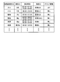
- FIG. 5 shows an example of the advance moving object information table.
- the items of the prior moving object information registered in the prior moving object information table include a moving object type ID, an individual ID, a detection time, an area ID, and gadget information. I have.
- the body type ID is information for identifying the type of a body such as a person, an animal (a cat or a dog), a movable furniture (a chair or a potted plant, etc.).
- the moving object type ID can be generated, for example, by the moving object detecting unit 114 executing a recognition process such as feature point extraction or pattern matching on the external world information.
- Individual ID is information for identifying an individual of a moving object.
- the individual ID is information for identifying an individual.
- This moving object type ID is, for example, a feature point extraction process or a pattern matching process for external world information based on information learned in the past by the moving object detection unit 114 or information registered in advance in a moving object information table by a user. And the like can be generated by executing a recognition process such as.
- the detection time is time information on the time (may be a time or a time zone) when the moving object exists in the target area, and is information on the time or the time zone when the moving object is detected.
- the detection time can be generated, for example, by the time when the moving object detection unit 114 specifies the time at which the external environment sensor 112 has acquired the external world information, or the time at which the external world information has been input from the external world sensor 112.
- Area ID is information for identifying the position or area where the moving object was detected, or the position or area where the autonomous mobile body 1 was present when the moving object was detected.
- region ID for example, information for specifying the position or region input from the self-position estimating unit 115 when the moving object detecting unit 114 detects the moving object can be used.
- the gadget information is information on whether or not a gadget is registered for the moving object when the individual identification (identification of the individual ID) of the moving object is successful, and when the gadget is registered for the moving object. Is the identification information.
- the gadget information may be, for example, information registered directly or indirectly in the advance moving object information table by the administrator of the autonomous mobile object 1 or the owner or administrator of the gadget.
- the gadget 105 in the present embodiment is a wearable terminal such as a mobile phone (including a smartphone), a smart watch, a portable game machine, a portable music player, a digital camera, a notebook personal computer (PC), and the like.
- the communication terminal may be a communication terminal equipped with an external sensor such as the sensor 105a, the IMU 105b, and the radio wave intensity sensor 105c that can specify the current position. Further, information registered in the advance moving object information table may be manually added / changed / deleted via a predetermined communication terminal such as the gadget 105.
- the optimum time estimating unit 117 determines that the ratio of the moving object information to the external world information acquired by using the external environment sensor 112 is the smallest based on the preliminary moving object information registered in the preliminary moving object information database 116. Estimate the deaf time zone. For example, the optimal time estimating unit 117 specifies the number of moving objects existing in the target area for each time zone, and determines the time zone in which the number of moving objects is the smallest based on the number to determine the optimal time for the target area. It is estimated. At this time, the optimal time may be estimated while weighting is performed according to the size of the moving object that can be specified from the moving object type ID or the individual ID.
- a value obtained by multiplying the number of detected persons by 10 is the same as a value obtained by multiplying the number of detected pets by 3. May be summed for each time zone, and the time zone with the smallest score may be estimated as the optimal time. Thereby, it is possible to estimate the time zone in which the proportion of the area occupied by the moving object in the image acquired by the camera 19 will be the smallest as the optimal time for acquiring the information used in creating the pre-map. It becomes.
- the optimal time estimating unit 117 In the estimation of the optimal time by the optimal time estimating unit 117, information acquired by an external sensor (GPS sensor 105a, IMU 105b, radio wave intensity sensor 105c, etc.) mounted on the gadget 105 owned by a person is utilized. Is also good. For example, if a gadget is registered for a moving object (mainly a person) identified by the individual ID in the prior moving object information table, the detection time and the area ID associated with the moving object are registered.
- the information specified by the external sensor of the gadget 105 may be preferentially used to estimate the optimal time.
- a preliminary map is created at an optimum time estimated using the information registered in the preliminary moving object information table
- information for example, presence / absence information
- information obtained in real time by an external sensor of the gadget 105. May be used to determine whether the process can be executed. In this case, for example, when there is a person who should normally go out, it is possible to determine that the preparation of the preliminary map is not executed.
- the optimum time estimated by the optimum time estimating unit 117 may vary depending on the type of the external sensor used, the target area, the weather condition (may be a forecast), the day of the week, and the like. For example, when an external sensor such as the camera 19 that is easily affected by the illuminance is used as the external sensor 112, the optimal time estimating unit 117 determines a high illuminance such as a bright time zone when the sun is coming out or a sunny day. A date and time that are easy to secure may be preferentially estimated as the optimal time.
- the optimal time estimating unit 117 preferentially prefers nighttime when it is estimated that there are relatively few moving objects.
- the optimal time may be estimated.
- an illuminance sensor is separately provided as the external sensor 112, and based on the value obtained by the illuminance sensor, an optimal time is estimated and a determination is made as to whether or not to execute the preliminary map creation process immediately before. May be.
- the illuminance may be detected using the camera 19 instead of the illuminance sensor.
- the optimal time estimating unit 117 instructs the preliminary map creating unit 118 (and, if necessary, the self-position estimating unit 115) to create a preliminary map at the optimal time estimated as described above.
- the preliminary map creator 118 moves the autonomous mobile 1 at the optimal time estimated by the optimal time estimator 117 to obtain external world information on the area for which the preliminary map is to be generated, and obtains the external world information thus obtained. Create a preliminary map using Then, the preliminary map creating unit 118 stores the created preliminary map in the preliminary map database 103.
- the self-position estimating unit 104 obtains, for example, a pre-map around the autonomous mobile 1 or an area to which the autonomous mobile 1 belongs from the pre-map database 103, and obtains the obtained pre-map and the external information input from the external sensor 112.
- the self-position of the autonomous mobile body 1 is estimated by the self-position estimation by the star reckoning method using.
- the self-position estimating unit 104 estimates the self-position of the autonomous moving body 1 by the self-position estimation of the dead reckoning method using the inner world information input from the inner world sensor 113, and Alternatively, a pre-map of the area to which the autonomous mobile unit 1 belongs is obtained from the pre-map database 103, and the self-position estimation is performed by the star reckoning method using the obtained pre-map and the external information input from the external sensor 112. The self-position estimated by the self-position estimation based on the dead reckoning method is corrected based on the self-position obtained by the above.
- each unit incorporated in the autonomous mobile unit 1 is realized by, for example, the CPU 12 (see FIG. 1) reading and executing a control program stored in the memory card 30 or the flash ROM 14.
- the CPU 12 see FIG. 1
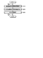
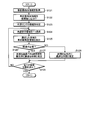
- FIG. 6 is a flowchart illustrating a schematic flow of the self-position estimation operation according to the present embodiment.
- the self-position estimating operation according to the present embodiment mainly includes a pre-mapping optimum time estimating step (step S100) for estimating an optimum time for pre-mapping, and an estimating optimum time.
- a self-position estimating prior map creating step (step S200) for creating a prior map and a self-position estimating step (step S300) for estimating a self-position using the created prior map are included.
- Step S100 in FIG. 6 is started.
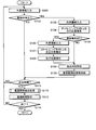
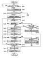
- FIG. 7 is a flowchart illustrating an operation example of the preliminary map creation optimum time estimation step according to the present embodiment.
- the outside world information acquired by the outside world sensor 112 of the autonomous moving object 1 is input to the moving object detection unit 114 (step S101), and the moving object detection is performed.
- the moving object detection is performed in the unit 114 (step S102).
- map matching and optical flow can be used for this moving object detection.
- the information specified by the moving object detection includes, for example, at least one of the moving object type ID and the individual ID.
- step S102 If the moving object is not detected as a result of the moving object detection in step S102 (NO in step S102), the operation proceeds to step S111.
- step S103 the inner-field information acquired by the inner-field sensor 113 is input to the self-position estimating unit 115 (step S103).
- Self-position estimation by the method is executed (step S104). Thereby, the self-position of the autonomous mobile body 1 is estimated.
- step S105 it is determined whether or not a pre-map for the area to which the autonomous mobile object 1 currently belongs has been created and downloaded from the pre-map database 103 (step S105). NO), the operation proceeds to step S109. On the other hand, if the prior map of the corresponding area has been downloaded (YES in step S105), the external information acquired by the external sensor 112 is input to the self-position estimating unit 115 (step S106). Self-position estimation by the star reckoning method is executed (step S107).
- step S104 the self-position estimated by the self-position estimation by the dead reckoning method in step S104 is corrected based on the self-position estimated by the self-position estimation by the star reckoning method in step S107 (step S108), and the process proceeds to step S109.
- the self-position obtained in step S104 or step S108 is information for specifying an area (area ID) in which the moving object has been detected in step S102, and is acquired as one of prior moving object information relating to this moving object. Is done.
- step S109 for example, the current time is specified as the time at which the moving object was detected in step S102 (step S109).
- This time is information for specifying the time (or time zone) at which the moving object was detected in step S102, and is acquired as one of the prior moving object information relating to this moving object.
- the advance moving object information database 116 may be arranged in the autonomous moving object 1 or may be arranged on the server 2 (see FIG. 3) connected to the autonomous moving object 1 via a predetermined network.
- step S111 it is determined whether a predetermined time has been reached.
- the predetermined time is a time at which a process of estimating an optimal time for acquiring information used in creating a pre-map is performed, for example, a predetermined time after the activation of the autonomous mobile body 1. It may be a time. If the predetermined time has not been reached (NO in step S111), the operation returns to step S101. On the other hand, when the predetermined time has been reached (YES in step S111), the optimal time estimating unit 117 executes an optimal time estimating process for estimating an optimal time for acquiring information used in creating a pre-map ( Step S112). A detailed example of the optimal time estimation process will be described later with reference to FIG.
- step S114 After setting the optimal time estimated in step S112 (step S113), it is determined whether or not the operation is to be ended (step S114). If not (NO in step S114), the process returns to step S101. . On the other hand, when the operation is to be ended (YES in step S114), the present operation is ended, and the process returns to the operation illustrated in FIG.
- the optimal time estimation unit 117 acquires a preliminary moving object information table (see FIG. 5) from the preliminary moving object information database 116 (Step S121). Subsequently, the optimal time estimating unit 117 sorts the advance moving object information for each moving object registered in the acquired optimal time information table for each area according to the area ID (step S122).
- the optimal time estimating unit 117 specifies the type of the external sensor 112 used when the autonomous mobile unit 1 acquires the external information for creating a preliminary map (step S123). For example, the optimal time estimating unit 117 determines whether the external sensor 112 used when acquiring external information for creating a pre-map from the pre-registered model or the like of the autonomous mobile body 1 is used when the information such as the camera 19 is acquired. It specifies whether the sensor requires illuminance or a sensor that does not require illuminance, such as the ToF sensor 21 or the LIDAR sensor.
- the optimal time estimating unit 117 selects one unselected region from among the region IDs whose information is registered in the advance moving object information table (step S124), and the moving object detected in the selected region.
- the prior moving object information relating to the moving object information is extracted from the prior moving object information table (step S125).
- the optimal time estimating unit 117 determines whether or not illuminance is required when obtaining external information for creating a preliminary map (step S126). If the illuminance is necessary (YES in step S126), the optimal time estimation unit 117 gives priority to the date and time at which a high illuminance can be easily secured, such as a bright time zone when the sun is coming, and the advance moving object for the selected area. An optimal time is estimated based on the information (step S127).
- the optimum time estimating unit 117 gives priority to nighttime in which the number of moving objects is estimated to be relatively small, based on the prior moving object information on the selected area. An optimal time is estimated (step S128).
- the number of moving objects existing in the target area is specified for each time zone, and the number of moving objects is determined based on the number.
- the time zone in which the number decreases is estimated as the optimal time for the target area.
- the optimal time may be estimated while weighting is performed according to the size of the moving object that can be specified from the moving object type ID or the individual ID.
- the optimal time estimating unit 117 determines whether or not all of the area IDs whose information is registered in the advance moving object information table have been selected (step S129), and if they have been selected (step S129). YES), this operation ends. On the other hand, when there is an unselected area (NO in step S129), the optimal time estimation unit 117 returns to step S124, selects one unselected area, and thereafter performs the same operation. As a result, for each of the area IDs whose information is registered in the advance moving object information table, the optimal time for acquiring the information used in creating the advance map is estimated.
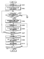
- FIG. 9 is a flowchart illustrating an operation example of the self-position estimation prior map creation step according to the present embodiment. Although the regions are not distinguished in FIG. 9, the self-position estimation preliminary map creation step shown in FIG. 9 may be executed for each region.
- the optimal time estimation unit 117 determines whether or not the optimal time set in the preliminary map creation optimal time estimation step has been reached (Ste S201).
- the optimal time estimating unit 117 acquires external world information from external sensors such as the GPS sensor 105a, the IMU 105b, and the radio wave intensity sensor 105c mounted on the gadget 105 (step S202). Then, it is determined whether or not a preliminary map can be created based on the outside world information (step S203).
- the optimum time estimating unit 117 determines that the creation of the advance map is not permitted when it is specified that the owner is present in the target area based on the outside world information acquired from the outside world sensor of the gadget 105. (NO in step S203). On the other hand, when it is determined that the owner does not exist in the target area, the optimal time estimating unit 117 determines that the creation of the advance map is permitted (YES in step S203).
- Step S203 is not limited to the external information acquired from the external sensor of the gadget 105, and it may be determined whether or not to create a preliminary map based on the illuminance information acquired by the illuminance sensor or the camera 19.
- step S203 If it is determined that the creation of the advance map is not permitted (NO in step S203), the operation returns to, for example, step S100 in FIG. 6, and executes the advance map creation optimal time estimation step again.
- the autonomous mobile body 1 is requested to reach the destination set in advance based on the advance terrain information or the information input by the user. The movement is started (step S204). Alternatively, the autonomous mobile unit 1 starts at random movement. Then, while the autonomous mobile object 1 is moving, the external world information acquired by the external sensor 112 of the autonomous mobile object 1 is sequentially input to the moving object detection unit 114 (step S205). Moving object detection is performed (step S206).
- step S206 for example, the number of moving objects included in the acquired external world information, the ratio of the moving object information in the external world information, and the like are specified.
- step S206 If no moving object is detected in step S206 (NO in step S206), the operation proceeds to step S207. On the other hand, if a moving object is detected (YES in step S206), it is determined whether the number of detected moving objects is larger than a predetermined number set in advance (step S215). If the number of detected moving objects is larger than the predetermined number (YES in step S215), the pre-map created for the area and stored in the pre-map database 103 is discarded (step S216), and this operation is performed. Proceed to step S213. On the other hand, when the number of detected moving objects is equal to or smaller than the predetermined number (NO in step S215), the operation proceeds to step S207.
- step S207 a local environment map around the autonomous mobile 1 is created as a part of the pre-map for the target area by using the external world information input in step S205.
- the inner field information acquired by the inner field sensor 113 of the autonomous moving body 1 is input to the self-position estimating unit 115 (step S208), and the self-position estimating unit 115 performs the self-position estimating by the dead reckoning method. (Step S209).
- it is determined whether the autonomous mobile body 1 has lost its own position step S210.
- the autonomous mobile body 1 is urgently stopped (step S217), and the area has been created and stored in the preliminary map database 103.
- the prior map is discarded (step S218), and then the operation is terminated (see FIG. 6).
- step S210 if the autonomous mobile body 1 has not lost its own position (NO in step S210), the local environment map created in step S207 is subjected to map matching with the pre-map stored in the pre-map database 103.
- the map is stored in the pre-map database 103 while being combined (step S211).
- step S212 it is determined whether or not the autonomous mobile body 1 has reached the destination (step S212). If the autonomous mobile body 1 has not reached the destination (NO in step S212), the process returns to step S205 to create a preliminary map. continue. On the other hand, when the autonomous mobile body 1 has reached the destination (YES in step S212), the autonomous mobile body 1 is moved to a predetermined position, for example, the position at the start of the movement in step S204 (for example, when the charger of the autonomous mobile body 1 is charged). Position) (step S213), and then stop the movement of the autonomous mobile body 1 (step S214), and then return to the operation shown in FIG.
- a predetermined position for example, the position at the start of the movement in step S204 (for example, when the charger of the autonomous mobile body 1 is charged). Position
- FIG. 10 is a flowchart illustrating an operation example of the self-position estimation step according to the present embodiment.
- the inner-field information acquired by the inner-field sensor 113 of the autonomous mobile 1 is input to the self-position estimator 104 (step S301).
- self-position estimating section 104 may have the same configuration as self-position estimating section 115, or may have a separate and independent configuration.
- the self-position estimating unit 104 performs self-position estimation by the dead reckoning method using the input inner world information (step S302). Thereby, the self-position of the autonomous mobile body 1 is estimated.
- the self-position estimating unit 104 determines whether or not a pre-map for the area to which the autonomous mobile 1 currently belongs is stored in the pre-map database 103. It is determined (step S303), and if it is not stored (NO in step S303), the process returns to step S100 in FIG. 6, and the execution from the preliminary map creation optimum time estimation step is repeated. On the other hand, when the pre-map of the area is stored in the pre-map database 103 (YES in step S303), the self-position estimating unit 104 acquires the pre-map of the area from the pre-map database 103 (step S304).
- the self-position estimating unit 104 inputs the inner-field information acquired by the inner-field sensor 113 of the autonomous mobile 1 (step S305), and performs self-position estimation by the dead reckoning method using the input inner-field information. Execute (step S306). Thereby, the self-position of the autonomous mobile body 1 is estimated again.
- the self-position estimating unit 104 determines whether or not the area to which the autonomous moving body 1 belongs has been changed based on the self-position of the autonomous moving body 1 estimated in step S306 (step S307). If YES (YES in step S307), the process returns to step S303 to execute the subsequent operations. On the other hand, when the area to which the autonomous mobile body 1 belongs has not been changed (NO in step S307), the self-position estimating unit 104 inputs the external world information acquired by the external sensor 112 of the autonomous mobile body 1 (step S308). Then, self-position estimation is performed by the star reckoning method using the input external world information and the pre-map obtained in step S304 (step S309).
- the self-position estimating unit 104 corrects the self-position estimated by the self-position estimation by the dead reckoning method in step S306 based on the self-position estimated by the self-position estimation by the star reckoning method in step S309 (step S309). S310).
- step S311 determines whether or not to end the operation (step S311), and if not (NO in step S311), returns to step S305 to execute the subsequent operations. On the other hand, when ending this operation (YES in step S311), self-position estimating section 104 ends this operation.
- the optimal time for acquiring the information used in creating the preliminary map is estimated, and the information for creating the preliminary map is estimated at the estimated optimal time.
- a time zone where the number of moving objects is small is estimated and a preliminary map is created in the time zone.
- the moving object is actually detected. For example, a case where the owner of the autonomous mobile body 1 returns home at a time different from the usual time, a case where a pet or the like starts moving at a time at which the autonomous mobile body 1 does not usually move, and the like can be considered. Therefore, in this embodiment, in order to cope with such a case, the moving object detection (step S206 in FIG. 9) is executed during the self-position estimation prior map creation step, and the detection result satisfies a predetermined condition. In this case (YES in step S215 in FIG. 9), the prior map created and stored in the prior map database 103 is discarded (step S216 in FIG. 9). As a result, it is possible to avoid storing a pre-map having a low information density in the pre-map database 103.
- the self-position estimation pre-map creation step it is necessary to estimate the self-position of the autonomous mobile 1 also during the self-position estimation pre-map creation step (step S209 in FIG. 9), but at this stage, the pre-map is still created. Not even if there is.
- the self-position estimation by the star reckoning method cannot be performed, and the self-position of the autonomous moving body 1 is estimated only by the self-position estimation by the dead reckoning method.
- the occurrence of the accumulated error may cause the autonomous mobile body 1 to lose its own position.
- the prior map created in a state where the autonomous moving body 1 has lost its own position may be an incorrect map. Therefore, in the present embodiment, the autonomous moving body 1 has lost its own position (FIG. 9).
- step S210 (YES in step S210), the autonomous mobile unit 1 is urgently stopped (step S217 in FIG. 9), and the preliminary map created and stored in the preliminary map database 103 is discarded (step S218 in FIG. 9). ). As a result, it is possible to prevent an inaccurate advance map from being stored in the advance map database 103.
- the self-position estimation prior map creation step (step S200 in FIG. 6) is not limited to one time for the activation of the autonomous mobile body 1, but is periodically (for example, every day) repeatedly executed. You may.
- the pre-map creation optimal time estimation step (step S100 in FIG. 6) is also periodically (for example, every day) repeatedly executed to accumulate pre-moving object information on many moving objects in the pre-moving object information database 116. It is possible to estimate the optimal time to obtain the information used in the preparation of the pre-map, and to prepare the pre-map at the optimum time, the information density of the pre-map The decrease is further suppressed, and more accurate self-position estimation becomes possible.
- the external sensor 112 obtains the external information used in the preparation of the pre-map at the optimum time estimated by the optimum time estimating unit 117, and the external sensor 112 obtains the information at the optimum time.
- the present invention is not limited to such a configuration and operation.
- an external world information database (external world information storage unit) 218 that stores the external world information acquired by the external world sensor 112 at the optimal time estimated by the optimal time estimation unit 117 is provided, and a preliminary map creation is performed.
- the unit 118 it is also possible to configure the unit 118 to create a preliminary map using the outside world information stored in the outside world information database 218 at an arbitrary or predetermined time.
- Other configurations and operations of the self-position estimating device (system) 200 shown in FIG. 11 may be the same as those of the self-position estimating device (system) 100 shown in FIG. .
- the present technology may also have the following configurations.
- (1) Based on time information on the time when the moving object has been present in the predetermined area based on the external world information of the predetermined area detected by the external world sensor, to create a preliminary map used when the mobile body estimates its own position based on the time information
- a determination unit that determines an acquisition time for acquiring the information of An information processing device comprising: (2) The information processing apparatus according to (1), wherein the determination unit determines the acquisition time based on a ratio of information of a moving object in external world information obtained using the external world sensor. (3) The information processing device according to (1), wherein the determination unit determines the acquisition time based on the number of moving objects existing in the predetermined area.
- a moving object information storage unit that stores the time information; The information processing apparatus according to (1), wherein the determination unit determines the acquisition time based on the time information stored in the moving object information storage unit.
- a detection unit that detects a moving object present around the external sensor using the external information acquired by the external sensor, The information processing device according to (1), wherein the determination unit determines the acquisition time based on time information specified when the detection unit detects the moving object.
- the apparatus further includes a generation unit that generates a type ID for specifying the type of the moving object based on the external information acquired by the external sensor.
- the information processing device according to (5), wherein the determination unit determines the acquisition time by weighting each time zone based on the time information and the type ID.
- a moving object information storage unit that stores the time information and the type ID relating to the same moving object in association with each other;
- the information processing device according to (6), wherein the determination unit determines the acquisition time based on the time information and the type ID stored in the moving object information storage unit.
- the method according to (1) further including a creating unit that creates a preliminary map using external world information acquired by the external world sensor as information for creating the preliminary map at the acquisition time determined by the determining unit.
- Information processing device is
- the creating unit in the process of creating a preliminary map using information for creating the preliminary map acquired at the acquisition time determined by the determination unit, the external world information acquired by the external sensor Based on the number of moving objects detected on the basis of the above, it is determined whether or not the prior map created based on the information for creating the advance map acquired at the acquisition time is to be discarded.
- An information processing apparatus according to claim 1.
- the image processing apparatus further includes: a generation unit configured to identify the moving object existing around the external sensor and generate an individual ID for identifying the identified moving object; Based on the time information and the individual ID regarding the same moving object, the determination unit determines whether or not a gadget including an external sensor related to the individual identified by the individual ID is provided and the gadget is registered.
- the acquisition time is determined by associating gadget information for identifying the gadget with the individual ID
- the creating unit determines whether the advance map can be created based on the gadget information.
- An inner field sensor that obtains at least one inner field information of a moving distance, a moving speed, a moving direction, and a posture of the moving body;
- a second estimating unit that estimates a second self-position of the moving body using the inner world information acquired by the inner world sensor;
- a generating unit that generates an area ID for specifying an area including the second self-position estimated by the second estimating unit when the moving object is detected,
- the information processing apparatus 11), wherein the determination unit determines the acquisition time for each area based on the time information and the area ID.
- the information processing apparatus in the process of creating a preliminary map using the information for creating the preliminary map acquired at the acquisition time determined by the determination unit, the creating unit, the second estimating unit of the moving body
- the information processing apparatus wherein when the self-position has been lost, the advance map created based on the information for creating the advance map acquired at the acquisition time is discarded.
- the apparatus further includes an inner field sensor for acquiring at least one piece of inner field information of a moving distance, a moving speed, a moving direction, and a posture of the moving body,
- the first estimating unit estimates a second self-position of the moving body using the inner-field information acquired by the inner-field sensor, and corrects the second self-position with the first self-position.
- An information processing device according to 11).
- the first estimating unit acquires the preliminary map created by the creating unit from the map storage unit, and uses the acquired preliminary map and the information acquired by the outside world sensor to acquire the moving object.
- the information processing apparatus according to (11), wherein the first self-position is estimated.
- the external sensor is at least one of a camera, a ToF (Time of Flight) sensor, a LIDAR (Light Detection and Ranging or Laser Imaging Detection and Ranging) sensor, a GPS (Global Positioning System) sensor, a magnetic sensor, and a radio wave intensity sensor.
- the information processing device including: (17) The information processing device according to (12), wherein the inner field sensor includes at least one of an inertial measurement device, an encoder, a potentiometer, an acceleration sensor, and an angular velocity sensor. (18) Based on time information on the time when the moving object has been present in the predetermined area based on the external world information of the predetermined area detected by the external world sensor, to create a preliminary map used when the mobile body estimates its own position based on the time information Determine the acquisition time to get the information of The optimal time estimation method.
- the inner field sensor includes at least one of an inertial measurement device, an encoder, a potentiometer, an acceleration sensor, and an angular velocity sensor.
- a self-position estimating method comprising estimating a self-position of the moving object using the created prior map and the external information acquired by the external sensor.
- the information processing device according to (4), wherein the determination unit determines, based on the time information, a time at which the number of moving objects existing in the predetermined area is estimated to be the smallest as the acquisition time. (23) The creating unit, when the number of moving objects present in the predetermined area exceeds a predetermined number, the creating unit based on the information for creating the advance map acquired at the acquisition time. The information processing device according to (12), wherein the previous map is discarded. (24) (10) The creating unit according to (10), wherein the creating unit specifies a current position of the gadget based on the gadget information, and disables creation of the advance map when the gadget exists in the predetermined area. Information processing device.
- a determination unit that determines an acquisition time for acquiring the information of An information processing system comprising:
Landscapes
- Engineering & Computer Science (AREA)
- Radar, Positioning & Navigation (AREA)
- Remote Sensing (AREA)
- Physics & Mathematics (AREA)
- General Physics & Mathematics (AREA)
- Automation & Control Theory (AREA)
- Theoretical Computer Science (AREA)
- Aviation & Aerospace Engineering (AREA)
- Computer Vision & Pattern Recognition (AREA)
- Multimedia (AREA)
- Evolutionary Computation (AREA)
- Artificial Intelligence (AREA)
- Data Mining & Analysis (AREA)
- Databases & Information Systems (AREA)
- Medical Informatics (AREA)
- Software Systems (AREA)
- Computing Systems (AREA)
- Health & Medical Sciences (AREA)
- General Health & Medical Sciences (AREA)
- Electromagnetism (AREA)
- Bioinformatics & Computational Biology (AREA)
- Bioinformatics & Cheminformatics (AREA)
- Life Sciences & Earth Sciences (AREA)
- Evolutionary Biology (AREA)
- General Engineering & Computer Science (AREA)
- Control Of Position, Course, Altitude, Or Attitude Of Moving Bodies (AREA)
- Navigation (AREA)
Abstract
L'objet de la présente invention est d'améliorer la précision d'estimation de position propre. Ce dispositif (système) de traitement d'informations (100) comprend une unité de détermination (117) qui détermine un instant d'acquisition auquel des informations servant à créer une carte d'avance sont acquises, la carte d'avance étant utilisée lorsqu'un corps mobile estime sa propre position, sur la base d'informations temporelles concernant l'instant auquel un objet mobile est présent dans une région prescrite basées sur des informations extérieures pour la région prescrite détectées par un capteur extérieur (112).
Priority Applications (1)
| Application Number | Priority Date | Filing Date | Title |
|---|---|---|---|
| US17/250,296 US20210271257A1 (en) | 2018-07-06 | 2019-05-27 | Information processing device, optimum time estimation method, self-position estimation method, and record medium recording computer program |
Applications Claiming Priority (2)
| Application Number | Priority Date | Filing Date | Title |
|---|---|---|---|
| JP2018129411 | 2018-07-06 | ||
| JP2018-129411 | 2018-07-06 |
Publications (1)
| Publication Number | Publication Date |
|---|---|
| WO2020008754A1 true WO2020008754A1 (fr) | 2020-01-09 |
Family
ID=69060070
Family Applications (1)
| Application Number | Title | Priority Date | Filing Date |
|---|---|---|---|
| PCT/JP2019/020971 Ceased WO2020008754A1 (fr) | 2018-07-06 | 2019-05-27 | Dispositif de traitement d'informations, procédé d'estimation d'instant optimal, procédé d'estimation de position propre et support d'enregistrement dans lequel un programme est enregistré |
Country Status (2)
| Country | Link |
|---|---|
| US (1) | US20210271257A1 (fr) |
| WO (1) | WO2020008754A1 (fr) |
Cited By (2)
| Publication number | Priority date | Publication date | Assignee | Title |
|---|---|---|---|---|
| WO2021157173A1 (fr) * | 2020-02-04 | 2021-08-12 | パナソニックIpマネジメント株式会社 | Dispositif d'aide à la conduite, véhicule, et procédé d'aide à la conduite |
| WO2021256322A1 (fr) * | 2020-06-16 | 2021-12-23 | ソニーグループ株式会社 | Dispositif de traitement d'informations, procédé de traitement d'informations et programme de traitement d'informations |
Families Citing this family (5)
| Publication number | Priority date | Publication date | Assignee | Title |
|---|---|---|---|---|
| WO2020183659A1 (fr) * | 2019-03-13 | 2020-09-17 | 学校法人 千葉工業大学 | Dispositif de traitement d'informations et robot mobile |
| WO2021117079A1 (fr) * | 2019-12-09 | 2021-06-17 | 日本電気株式会社 | Dispositif d'estimation d'autoposition, procédé d'estimation d'autoposition, et programme |
| JP7766406B2 (ja) * | 2021-03-12 | 2025-11-10 | キヤノン株式会社 | 画像処理装置および画像処理方法 |
| US12132986B2 (en) * | 2021-12-12 | 2024-10-29 | Avanti R&D, Inc. | Computer vision system used in vehicles |
| JP7527322B2 (ja) * | 2022-03-24 | 2024-08-02 | 三菱重工業株式会社 | 情報処理方法、情報処理装置及びプログラム |
Citations (4)
| Publication number | Priority date | Publication date | Assignee | Title |
|---|---|---|---|---|
| JP2004298975A (ja) * | 2003-03-28 | 2004-10-28 | Sony Corp | ロボット装置、障害物探索方法 |
| JP2014203145A (ja) * | 2013-04-02 | 2014-10-27 | パナソニック株式会社 | 自律移動装置 |
| JP2014209293A (ja) * | 2013-04-16 | 2014-11-06 | 富士ゼロックス株式会社 | 経路探索装置、自走式作業装置、プログラム及び記録媒体 |
| JP2018005470A (ja) * | 2016-06-30 | 2018-01-11 | カシオ計算機株式会社 | 自律移動装置、自律移動方法及びプログラム |
Family Cites Families (12)
| Publication number | Priority date | Publication date | Assignee | Title |
|---|---|---|---|---|
| JP4175165B2 (ja) * | 2002-04-17 | 2008-11-05 | 松下電工株式会社 | 自律移動装置 |
| JP4211654B2 (ja) * | 2004-03-30 | 2009-01-21 | 株式会社デンソー | ナビゲーション装置および情報センタ |
| JP5366046B2 (ja) * | 2009-03-04 | 2013-12-11 | 株式会社国際電気通信基礎技術研究所 | 移動体管理システム、移動体管理装置および移動体管理プログラム |
| KR20130127822A (ko) * | 2012-05-15 | 2013-11-25 | 한국전자통신연구원 | 도로상 물체 분류 및 위치검출을 위한 이종 센서 융합처리 장치 및 방법 |
| JP2015111336A (ja) * | 2013-12-06 | 2015-06-18 | トヨタ自動車株式会社 | 移動ロボット |
| JP6413621B2 (ja) * | 2014-10-22 | 2018-10-31 | 株式会社デンソー | 車載用物体判別装置 |
| JP6520048B2 (ja) * | 2014-10-30 | 2019-05-29 | 村田機械株式会社 | 移動体 |
| US9474042B1 (en) * | 2015-09-16 | 2016-10-18 | Ivani, LLC | Detecting location within a network |
| JP2017091845A (ja) * | 2015-11-11 | 2017-05-25 | 三菱電機株式会社 | 照明制御システム |
| JP6752118B2 (ja) * | 2016-11-09 | 2020-09-09 | 東芝ライフスタイル株式会社 | 自律走行体 |
| JP6882664B2 (ja) * | 2017-02-07 | 2021-06-02 | 富士通株式会社 | 移動体位置推定システム、移動体位置推定端末装置、情報格納装置、及び移動体位置推定方法 |
| JP7353747B2 (ja) * | 2018-01-12 | 2023-10-02 | キヤノン株式会社 | 情報処理装置、システム、方法、およびプログラム |
-
2019
- 2019-05-27 WO PCT/JP2019/020971 patent/WO2020008754A1/fr not_active Ceased
- 2019-05-27 US US17/250,296 patent/US20210271257A1/en not_active Abandoned
Patent Citations (4)
| Publication number | Priority date | Publication date | Assignee | Title |
|---|---|---|---|---|
| JP2004298975A (ja) * | 2003-03-28 | 2004-10-28 | Sony Corp | ロボット装置、障害物探索方法 |
| JP2014203145A (ja) * | 2013-04-02 | 2014-10-27 | パナソニック株式会社 | 自律移動装置 |
| JP2014209293A (ja) * | 2013-04-16 | 2014-11-06 | 富士ゼロックス株式会社 | 経路探索装置、自走式作業装置、プログラム及び記録媒体 |
| JP2018005470A (ja) * | 2016-06-30 | 2018-01-11 | カシオ計算機株式会社 | 自律移動装置、自律移動方法及びプログラム |
Cited By (15)
| Publication number | Priority date | Publication date | Assignee | Title |
|---|---|---|---|---|
| CN115053279B (zh) * | 2020-02-04 | 2023-10-20 | 松下知识产权经营株式会社 | 驾驶辅助装置、车辆及驾驶辅助方法 |
| US12103519B2 (en) | 2020-02-04 | 2024-10-01 | Panasonic Automotive Systems Co., Ltd. | Driving assistance apparatus, vehicle, and driving assistance method |
| JP7838132B2 (ja) | 2020-02-04 | 2026-03-31 | パナソニックオートモーティブシステムズ株式会社 | 運転支援装置、及び、運転支援方法 |
| CN115053279A (zh) * | 2020-02-04 | 2022-09-13 | 松下知识产权经营株式会社 | 驾驶辅助装置、车辆及驾驶辅助方法 |
| JP7316612B2 (ja) | 2020-02-04 | 2023-07-28 | パナソニックIpマネジメント株式会社 | 運転支援装置、車両、及び、運転支援方法 |
| JP2023130448A (ja) * | 2020-02-04 | 2023-09-20 | パナソニックIpマネジメント株式会社 | 運転支援方法、及び、運転支援装置 |
| JP2021124898A (ja) * | 2020-02-04 | 2021-08-30 | パナソニックIpマネジメント株式会社 | 運転支援装置、車両、及び、運転支援方法 |
| JP7445881B2 (ja) | 2020-02-04 | 2024-03-08 | パナソニックIpマネジメント株式会社 | 運転支援方法、及び、運転支援装置 |
| WO2021157173A1 (fr) * | 2020-02-04 | 2021-08-12 | パナソニックIpマネジメント株式会社 | Dispositif d'aide à la conduite, véhicule, et procédé d'aide à la conduite |
| JP2024050891A (ja) * | 2020-02-04 | 2024-04-10 | パナソニックオートモーティブシステムズ株式会社 | 運転支援装置、及び、運転支援方法 |
| JP2025061006A (ja) * | 2020-02-04 | 2025-04-10 | パナソニックオートモーティブシステムズ株式会社 | 運転支援装置、及び、運転支援方法 |
| JP7619748B2 (ja) | 2020-02-04 | 2025-01-22 | パナソニックオートモーティブシステムズ株式会社 | 運転支援装置、及び、運転支援方法 |
| US20230350422A1 (en) * | 2020-06-16 | 2023-11-02 | Sony Group Corporation | Information processing apparatus, information processing method, and information processing program |
| US12455572B2 (en) | 2020-06-16 | 2025-10-28 | Sony Group Corporation | Information processing apparatus, information processing method, and information processing program |
| WO2021256322A1 (fr) * | 2020-06-16 | 2021-12-23 | ソニーグループ株式会社 | Dispositif de traitement d'informations, procédé de traitement d'informations et programme de traitement d'informations |
Also Published As
| Publication number | Publication date |
|---|---|
| US20210271257A1 (en) | 2021-09-02 |
Similar Documents
| Publication | Publication Date | Title |
|---|---|---|
| US20210271257A1 (en) | Information processing device, optimum time estimation method, self-position estimation method, and record medium recording computer program | |
| JP3945279B2 (ja) | 障害物認識装置、障害物認識方法、及び障害物認識プログラム並びに移動型ロボット装置 | |
| US10948907B2 (en) | Self-driving mobile robots using human-robot interactions | |
| CN113116224B (zh) | 机器人及其控制方法 | |
| CN111837083B (zh) | 信息处理装置、信息处理方法和存储介质 | |
| CN114564027B (zh) | 足式机器人的路径规划方法、电子设备及可读存储介质 | |
| CN110400490A (zh) | 轨迹预测方法和装置 | |
| CN107194970B (zh) | 自主移动装置、自主移动方法以及程序存储介质 | |
| KR102826068B1 (ko) | 로봇의 위치 인식 | |
| JP2019500693A (ja) | 自律視覚ナビゲーション | |
| JP2004110802A (ja) | 環境同定装置、環境同定方法、プログラム及び記録媒体、並びにロボット装置 | |
| KR102837653B1 (ko) | 대면적의 공간에서 로컬 영역별로 위치를 추정하는 방법 및 이를 구현하는 로봇과 클라우드 서버 | |
| CN114683290B (zh) | 一种足式机器人位姿优化的方法,装置以及存储介质 | |
| CN109839118A (zh) | 路径规划方法、系统、机器人和计算机可读存储介质 | |
| JP2018163614A (ja) | 自律移動装置、自律移動方法およびプログラム | |
| US12265392B2 (en) | Information processing device, information processing system, and behavior planning method | |
| US11926038B2 (en) | Information processing apparatus and information processing method | |
| KR102368734B1 (ko) | 드론 및 드론 제어 방법 | |
| US12216467B2 (en) | Self-location estimation device, autonomous mobile body, and self-location estimation method | |
| CN114995459A (zh) | 机器人的控制方法、装置、设备及存储介质 | |
| KR102830221B1 (ko) | 로봇의 위치 인식 | |
| EP3832421A1 (fr) | Dispositif de traitement d'informations, procédé de détermination d'action et programme | |
| US12422850B2 (en) | Information processing apparatus and information processing method to manage path information of a mobile robot | |
| US20210107143A1 (en) | Recording medium, information processing apparatus, and information processing method | |
| US20240118703A1 (en) | Display apparatus, communication system, display control method, and recording medium |
Legal Events
| Date | Code | Title | Description |
|---|---|---|---|
| 121 | Ep: the epo has been informed by wipo that ep was designated in this application |
Ref document number: 19829965 Country of ref document: EP Kind code of ref document: A1 |
|
| NENP | Non-entry into the national phase |
Ref country code: DE |
|
| 122 | Ep: pct application non-entry in european phase |
Ref document number: 19829965 Country of ref document: EP Kind code of ref document: A1 |
|
| NENP | Non-entry into the national phase |
Ref country code: JP |